Maclean, New South Wales

Last updated

Maclean
New South Wales
St Mary's Catholic Church, Maclean, NSW, 01.jpg
St Mary's Catholic Church
Australia New South Wales location map blank.svg
Red pog.svg
Maclean
Coordinates 29°27′S153°12′E / 29.450°S 153.200°E / -29.450; 153.200
Population2,778, [1] The total urban area inc contiguous suburbs, Townsend & Gulmarrad (2463 postcode) is 8,304 [2]  (2021 census)
Postcode(s) 2463
Elevation9 m (30 ft)
Location
LGA(s) Clarence Valley Council
State electorate(s) Clarence
Federal division(s) Page

Maclean is a town in Clarence Valley local government area in the Northern Rivers region of New South Wales, Australia. It is on the Clarence River and near the Pacific Highway. At the 2021 census, Maclean had a population of 2,778, [1] total urban area including Townsend and Gulmarrad (postcode 2463) is more than 8,304 [2] . The Maclean, Yamba and Iluka area known as the Lower Clarence had a combined population of 17,533. [3] Its industries are tourism, sugar cane production, farming and river-prawn trawling. Together with Grafton, Maclean is the shared administrative centre for the Clarence Valley Council local government area.

Contents

Geography

Maclean is nestled at the base of Mt Maclean and the shoreline of the Clarence River where the river reunites after splitting around Woodford Island. A bridge connects Woodford Island to Maclean. It is part of the Tourist Drive 22. During times of heavy rain the town is under threat of flooding by the surging waters of the river.

The Pacific Highway bypass of Maclean was opened in 1966 in conjunction with the first Harwood Bridge over the South Channel of the Clarence. The bypass was duplicated and the bridge superseded by a four-lane bridge in 2020 (the 1966 bridge has been retained for local traffic).

History

The area was originally inhabited by the Gumbaingirr or Yaygir indigenous peoples. Matthew Flinders landed near the mouth of the Clarence River in 1799, naming it Shoal Bay, but dismissed the area as "deserving of no more than a superficial examination".

Several escaped convicts from Moreton Bay passed through the area on their way south in the 1820s and 30s, with one convict (Richard Craig) reporting a "big river" on the way.

In 1838, Thomas Small sent his brother and two dozen sawyers from Sydney on board the Susan down the "big river," becoming the first vessel to pass down the river. Attracted by the large amount of red cedar growing in the area, Small settled on Woodford Island at the end of the year. The following year, Governor Sir George Gipps named the river the Clarence in honour of the Duke of Clarence. Soon after, the name Rocky Mouth was given to the area now known as Maclean.

The township was officially laid out in 1862 and named after Alexander Grant McLean, the Surveyor-General, by the Grafton Commissioner for Lands, W.A.B. Greaves. Many of the early settlers came from the Scottish Highlands, with numerous Irish and German immigrants also settling.

The arrival of Europeans forced the Yaegl people off their land and they were forced into smaller settlements. Several massacres of Indigenous people by settlers were recorded along the Clarence River. By 1880, Ulgundahi Island had become a sit of occupation by some of the displaced Yaegls.

Early crops in the area were maize and cotton, before sugar began to take over as the dominant crop by the mid-1860s. The Harwood Sugar Mill opened in 1874 and is Australia's oldest continuously operating sugar mill. [4]

In 1887, Maclean was declared a municipality.

The Ashby Ferry opened between Maclean and Ashby in 1890, travelling across the Clarence River from MacNaughton Place. It was proposed in as part of a railway line which was to run from Grafton to Tweed, crossing the Clarence River at Maclean to Ashby and heading north to Coraki, so as to minimise the amount of river crossings required. [5] This ferry was hand-winched to get across the river and was replaced by a steam ferry in 1920. The steam ferry was replaced by an old Bluff Point Ferry in 1974, but was still used as a relief ferry until 1981 when it was decommissioned and put on display at the Ferry Park. The ferry crossing became a public boat ramp whne the bridge connecting Ashby to Chatsworth Island opened in 1981. [6]

In 1906, the McFarlane Bridge opened over the South Arm of the Clarence River, providing easier access between Maclean and Woodford Island. It last opened to allow boats through in 1962.

In 1957, Maclean became a shire.

The high school moved to its current site on Woombah Street in 1961. It was previously on the same site as the primary school.

The town suffered an economic downturn after the Pacific Highway bypassed it in 1966, with sugar prices dropping sharply. In order to attract tourists to the area, the town leant on its Scottish heritage, with the Scottish Cairn constructed.

As part of the torch relay ahead of the 2000 Summer Olympics in Sydney, several of the power poles around the town were painted with Scottish tartans. Originally, only 100 were painted, however there are now around 240 in Maclean and surrounds. [7]

In 2004, Maclean Shire was forcibly amalgamated with Grafton City and several other small local councils to form the Clarence Valley Council.

Flooding

Due to its location on the banks of the Clarence River, Maclean has recorded over 100 floods since the town was settled by Europeans. [8] There were three floods recorded in 1890, then nothing from 1893 until 1921. Another flood followed in 1928, then a disastrous period from 1945-56 when numerous floods were recorded, including four in 1950 alone. The June flood of that year was the largest recorded since 1890. [9] Large floods were recorded in 1963 and 1967, before record floods were recorded in 1974, with the flood of 2001 exceeding that mark. Markers indicating the height of the 2001 flood can be found on some poles around town.

The levee wall was constructed after the 2001 flood, saving Maclean from inundation during the 2009, 2011, 2013 and 2021 floods, however the town was still isolated after both roads to the highway were cut.

Despite some cracks forming in the levee, Maclean narrowly avoided being completely inundated during the 2022 floods. Several low-lying parts of the town, including the Showground and Cameron Park were still flooded.

Heritage listings

Maclean has a number of heritage-listed sites, including:

Culture

River Street River Street, Maclean, New South Wales, 2021, 21.jpg
River Street

The popular Maclean Highland Gathering has been held for over 100 years during the Easter weekend. Participants and bands contest traditional Scottish athletic and cultural competitions, such as caber tossing, highland dancing, band competition, and bagpiping. The "Maclean, The Scottish Town In Australia Association", is a community group which was formed in 1986 under the initiative of former bank manager Mr Graham Leach, and works to promote Maclean's strong Scottish origins. The work of this committee over the years has ensured that Maclean now has national and international recognition as 'The Scottish Town' in Australia.

Many street signs are written in English and Scottish Gaelic, power poles are painted with tartan patterns, and a stone cairn has been erected in Herb Stanford Park.

The Maclean Agricultural Show was first held in 1896 and has been held almost every since, only missing a handful of occasions due to things like flooding, storm damage and Covid-19.

Sport

Maclean is home to several local sporting teams. It's the central town for the Lower Clarence Cricket Association, with a turf wicket at Barry Watts Oval and three synthetic pitches at Wherrett Park. Maclean Bobcats compete in the Football Far North Coast competition and play home games at Barry Watts Oval during the winter months. Junior sport, including rugby league and soccer, as well as school sport, is also played at Wherrett Park. The Lower Clarence Netball Association plays games at the adjacent Chris O'Connell Netball Courts.

The Maclean Indoor Sports Centre is also located within the Wherrett Park complex, as is the Maclean skate park.

The Lower Clarence Magpies formerly played home games at the Maclean Showground, but relocated to Yamba in the mid-2010s.

Rowing was the dominant sport in the early years of the town, with the Lower Clarence Rowing Club forming in 1885.

MacNaughton Park on the site of the present primary school hosted many sports prior to 1900, but was quickly replaced. Jubilee Park was the former home of Maclean sports and was located behind the Maclean Bowling Club and Maclean Olympic Pool. It suffered extensive damage in the 1974 flood and closed shortly after. These days the site is occupied by IGA, a carpark and Cameron Park.

Schools

Newspapers

Related Research Articles

<span class="mw-page-title-main">Grafton, New South Wales</span> City in New South Wales, Australia

Grafton is a city in the Northern Rivers region of the Australian state of New South Wales. It is located on the Clarence River, approximately 608 kilometres (378 mi) by road north-northeast of the state capital Sydney. The closest major cities, Brisbane and the Gold Coast, are located across the border in South-East Queensland. At the 2021 census, Grafton had a population of 19,255. The city is the largest settlement and, with Maclean, the shared administrative centre of the Clarence Valley Council local government area, which is home to over 50,000 people in all.

<span class="mw-page-title-main">Northern Rivers</span> Region in New South Wales, Australia

Northern Rivers is the most north-easterly region of the Australian state of New South Wales, located between 590 and 820 kilometres north of the state capital, Sydney, and encompasses the catchments and fertile valleys of the Clarence, Richmond, and Tweed rivers. It extends from Tweed Heads in the north to the southern extent of the Clarence river catchment which lies between Grafton and Coffs Harbour, and includes the main towns of Tweed Heads, Byron Bay, Ballina, Kyogle, Lismore, Casino and Grafton. At its most northern point, the region is 102 kilometres (63 mi) south-southeast of the Queensland capital, Brisbane.

<span class="mw-page-title-main">Clarence Valley Council</span> Local government area in New South Wales, Australia

Clarence Valley Council is a local government area in the Northern Rivers region of New South Wales, Australia.

Mororo is a small area in the Clarence Valley of New South Wales in Australia. Mororo is dominated by sugar cane farms & does not have a large area of suburbia. The population of Mororo is roughly 40. It is located on the Pacific Motorway and is located in the Bundjalung National Park. Mororo has three residential roads, Banana Road, Lewis Lane, and Mororo Road. It is close to Woombah, Iluka, Maclean, Yamba and Woodburn.

<span class="mw-page-title-main">Yamba, New South Wales</span> Town in New South Wales, Australia

Yamba is a town in the Northern Rivers region of New South Wales, Australia located at the mouth of the Clarence River.

<span class="mw-page-title-main">Clarence River (New South Wales)</span> River in New South Wales, Australia

The Clarence River is a river situated in the Northern Rivers district of New South Wales, Australia.

<span class="mw-page-title-main">Iluka, New South Wales</span> Town in New South Wales, Australia

Iluka is a small village at the mouth of the Clarence River in north-eastern New South Wales, Australia. It is situated directly across the river from the resort town of Yamba. At the 2016 census, Iluka had a population of 1,718 people. The town's name is derived from an Aboriginal word meaning "near the sea".

<span class="mw-page-title-main">Woodford Island</span> Locality in New South Wales, Australia

Woodford Island is an inland island in the Far-North Coast of New South Wales, Australia. It is formed by the Clarence River where it splits into the South Arm and North Arm at the small village of Brushgrove then reforms at the town of Maclean. The island is the largest in NSW, either inland or offshore, at 37 km2.

<span class="mw-page-title-main">Ulmarra</span> Town in New South Wales, Australia

Ulmarra is a small town on the south bank of the Clarence River in New South Wales, Australia in the Clarence Valley district. At the 2006 census, Ulmarra had a population of 446 people.

Lawrence is a small town 13 km from Maclean, New South Wales, Australia. It is accessed by the Lawrence car ferry from Woodford Island or by travelling 30 kilometres north from Grafton. At the 2021 census, the population of Lawrence was 1159.

<span class="mw-page-title-main">Woombah, New South Wales</span> Town in New South Wales, Australia

Woombah is a small but growing bushland village in Clarence Valley, New South Wales, Australia. This hamlet is located to the south of the World Heritage-listed Bundjalung National Park, near the Port of Yamba on Goodwood Island, and 15 minutes from the fishing village of Iluka, New South Wales.

The Bluff Point Ferry, Lawrence is a cable ferry across the Clarence River in New South Wales, Australia. The ferry operates between the town of Lawrence and Woodford Island, and forms part of the route east from Lawrence to the coast. It is the busiest vehicular ferry in New South Wales.

The Daily Examiner is a daily newspaper serving Grafton, New South Wales, Australia. The newspaper is owned by News Corp Australia. At various times the newspaper was known as The Clarence and Richmond Examiner and New England Advertiser (1859–1889) and Clarence and Richmond Examiner (1889–1915).

<span class="mw-page-title-main">Harwood Bridge</span> Mostly disused roadbridge in New South Wales, Auatralia

The Harwood Bridge is a two-lane steel truss bridge which carried the Pacific Highway over the Clarence River in the Northern Rivers region of New South Wales, Australia from 1966 until 2019, when it was replaced by a four-lane 1.5-kilometre-long (4,921 ft) concrete bridge, located 20 metres (66 ft) to its east. The Harwood Bridge has been retained to provide access to Harwood Island.

<span class="mw-page-title-main">Nymboida, New South Wales</span> Town in New South Wales, Australia

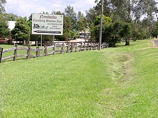
Nymboida is a rural village in the Northern Rivers region of New South Wales, Australia. It is about 21 kilometres south-west of Coutts Crossing, 44 kilometres south-west of Grafton and approximately 687 km north of Sydney. Nymboida is close to the challenging and popular white water rafting waters of the Nymboida River along the Armidale–Grafton Road. The village is in the Clarence Valley Council local government area.

The Yaygir, Yuraygir, or Yaegl, are an Australian Aboriginal tribe who traditionally live and lived in and around Yamba and Maclean, New South Wales.

<span class="mw-page-title-main">Ulgundahi Island</span> Historic site in New South Wales, Australia

Ulgundahi Island is a heritage-listed Aboriginal site, formerly an occupational settlement, with ongoing usage as farmland and as a site of ongoing significance, at Clarence River by North Arm, Maclean, Clarence Valley Council, New South Wales, Australia. The property is owned by the Yaegl Local Aboriginal Land Council. It was added to the New South Wales State Heritage Register on 24 December 2004.

Harwood Shire was a local government area in the Northern Rivers region of New South Wales, Australia.

<span class="mw-page-title-main">Harwood, New South Wales</span> Town in New South Wales, Australia

Harwood is a village on the Clarence River, 5 km north-east of Maclean in northern New South Wales. As of the 2016 census, Harwood had a population of 291. It is known for sugar cane production, with the Harwood Sugar Mill located on the eastern side of town.

The Lower Clarence Magpies are an Australian rugby league football club based in Yamba, New South Wales. The club was founded as Maclean in 1915, later becoming Lower River. They rebranded again as Lower Clarence when they joined the newly formed Group 1 competition in 1966.

References

  1. 1 2 Australian Bureau of Statistics (28 June 2022). "Maclean". 2021 Census QuickStats. Retrieved 28 June 2022. OOjs UI icon edit-ltr-progressive.svg
  2. 1 2 Australian Bureau of Statistics (28 June 2022). "2463, NSW". 2021 Census QuickStats. Retrieved 28 June 2022. OOjs UI icon edit-ltr-progressive.svg
  3. Australian Bureau of Statistics (28 June 2022). "Maclean – Yamba – Iluka". 2021 Census QuickStats. Retrieved 28 June 2022. OOjs UI icon edit-ltr-progressive.svg
  4. "Harwood Mill & Refinery". Sunshine Sugar. Sunshine Sugar. Retrieved 20 April 2023.
  5. "Lower Clarence History" (PDF). Clarence Valley Council. Clarence Valley Council. Retrieved 20 April 2023.
  6. "A monument to the Clarence River's past". 10 February 2018. Retrieved 20 April 2023.
  7. ABC North Coast (15 November 2017). "Curious North Coast: Why is Maclean the most Scottish town in Australia?" . Retrieved 20 April 2023.
  8. "Lower Clarence History" (PDF). Clarence Valley Council. Clarence Valley Council. Retrieved 20 April 2023.
  9. "1950 on the Clarence". The Daily Examiner. Retrieved 23 April 2023.
  10. "Ulgundahi Island". New South Wales State Heritage Register . Department of Planning & Environment. H01721. Retrieved 18 May 2018. CC BY icon.svg Text is licensed by State of New South Wales (Department of Planning and Environment) under CC-BY 4.0 licence .