Ocean Shores, New South Wales

Last updated

Ocean Shores
New South Wales
View of Ocean Shores, NSW, from Lookout Park 2014.jpg
View of Ocean Shores from Lookout Park
Australia New South Wales location map blank.svg
Red pog.svg
Ocean Shores
Coordinates 28°31′19″S153°32′24″E / 28.52194°S 153.54000°E / -28.52194; 153.54000 Coordinates: 28°31′19″S153°32′24″E / 28.52194°S 153.54000°E / -28.52194; 153.54000
Population5,137 (2016 census) [1]
Established1977
Postcode(s) 2483
Elevation3 m (10 ft)
Location
LGA(s) Byron Shire
State electorate(s) Ballina
Federal division(s) Richmond
Mean max tempMean min tempAnnual rainfall
 ??1,723.5 mm
67.9 in

Ocean Shores is a coastal town in the Northern Rivers region of New South Wales, Australia [2] with Billinudgel to the north and South Golden Beach and New Brighton to the east of the town. [3] Established in 1977, [2] Ocean Shores was originally a land holding owned by Wendell West of Washington with backing from American singer Pat Boone, [3] and was named after Boone's residence in Ocean Shores, Washington. It is located in the Brunswick Valley – a valley including the towns of Mullumbimby and Brunswick Heads. [4] The town has a local shopping complex and a large golf course. At the 2016 census, Ocean Shores had a population of 5,137 people. [1]

Contents

Climate

Ocean Shores has a subtropical climate. [5] Summer is generally warm to hot with a few days reaching above 30 degrees. Winter is cool to mild with around two days under 14 degrees. Normal day maximums are around 20 degrees. Spring and autumn are mild to warm, with maximums around 25 and higher with few days below it. [6] Winds come from all directions which means there are warm northerly days or mild southerly days. Spring is dry and windy. Thunderstorms are also common in summer.

Geography

Yallakool Drive Yallakool Drive, Ocean Shores, NSW 2014.jpg
Yallakool Drive
A private residence Private residence, Tongarra Drive, Ocean Shores, NSW 2014.jpg
A private residence
Water Lily Park Waterlily Park, Ocean Shores, NSW 2014.jpg
Water Lily Park
The beach Beach, Ocean Shores, NSW 2014.jpg
The beach

Southern Ocean Shores is located on the edge of the Brunswick River catchment, which means most of the terrain is elevated and has sea views. Northern Ocean Shores is located on mostly flat land on the beach. The north arm of the Brunswick River weaves through the north of the town. [7]

Ocean Shores Public School and Ocean Shores Pre-School are located in Ocean Shores North. Ocean Shores Public School was established in 1993 after relocating the Billinudgel Public School to the new school at Ocean Shores. [8]

A canal called 'Capriconia Canal' runs through Ocean Shores North and connects to Yelgun Creek. Most of Ocean Shores North lies next to the Billinudgel Nature Reserve.

Ocean Shores is located on the New South Wales side of the New South Wales/Queensland border with Billinudgel to the north and South Golden Beach and New Brighton to the east of the town. Brisbane, the capital of Queensland, is closer than Sydney, the capital of New South Wales. The closest urban areas are Lismore and Tweed Heads.

Transportation

Ocean Shores has a local bus service five times per day, linking the greater Ocean Shores community, Brunswick Heads, Mullumbimby, Byron Bay and Ballina. Ocean Shores is located between two airports, Ballina to the south, which has daily flights to Sydney and Melbourne, and Gold Coast to the north, which has daily services to most major Australian cities and a few international destinations. The closest closed railway station is at Mullumbimby, a 10-minute drive south. In the past, train service travelled down the North Coast line to Sydney, but the Murwillumbah line closed on 19 May 2004 and services now depart from Casino with NSW TrainLink operating road coaches.

Community and history

The people of Ocean Shores live in a coastal and estuarine environment. The community consists of a mix of more recently migrated inhabitants from all over the world, as well as people who have lived in the district all of their lives. [9] Members of the Midjimbul / Durumbil clans are the traditional custodians of the area. There are Aboriginal sites in the area, including middens along Marshalls Creek. The area is rich in indigenous heritage. The Brunswick, which included the Ocean Shores area, was the first place of European settlement in what is now called the Byron Shire, dating back to 1846. [10]

The Ocean Shores Community Association (OSCA) and its predecessors, have worked for community issues in the Ocean Shores district, since the town was founded.

Mungo Wentworth MacCallum was a noted resident.

In March 2022, Ocean Shores was hit by floods which left many buildings destroyed. [11]

Local farmers' market

The Local New Brighton Farmer's Market opens every Tuesday morning from 8 am to 11 am. [12]

Arts and culture

The Ocean Shores Arts Expo is an annual art exhibition which features art in the following categories: Watercolour & Gouache, Mixed Media, Printmaking, Drawing & Pastels, Oil & Acrylic, Sculpture / 3D art, Photography and Digital Art. [13] It began in 2004 when a group of residents who had come together during the Pacific Highway planning controversy decided to create something uplifting, creative and positive for the community. Lions of Brunswick/Mullumbimby financially supported the project as a worthy cultural event to bring community together. Local history has been an important cornerstone of the Expo every year with our local historian Frank Mills. The Art Expo has taken place over a weekend in August every year. Then over the weekend there are local musicians performing, art demonstrations, the Youth art show, a community artwork, and the Artists cafe. [14]

Retail shopping

The Ocean Village Shopping Centre is a central meeting place for Ocean Shores residents. It has a variety of stores including a Coles supermarket, chemist, cafes, FDBs, butcher and Country Target next door. New Brighton shops include a real estate agent and holistic health centre, general store, liquor store, post office and café. South Golden Beach has a general store and take away café. [15]

The entrance to the rural hinterland of The Pocket and Main Arm is Billinudgel. Billinudgel village has a variety of retail shops including a general store, the historic Billinudgel Hotel, post office, hair dresser and many others. Billinudgel also has a large industrial estate including tire shops for auto repairs, storage units, the Brunswick Valley bus depot, Green Pack Wholesale restaurant supply, Cawarra cosmetics manufacturer, hardware shops, sunglass repair shop Sunglass Fix and a curtain blinds factory. [16] [17] [18]

Business and local economy

The Ocean Shores and surrounding area established a business networking group in 2012, [19] called Business Ashored, to promote and support trade and the local economy.

Sports and outdoor

The Ocean Shores Golf Course is an 18 hole course (No. 9 in NSW). [20]

There are seven km of ocean surf beach, from the North Head of the Brunswick River to Wooyun creek. New Brighton Sports Oval and the new Ocean Shores Sportsfield, provides regular soccer practice and is the home of Shores United Soccer Club, involving junior and men's teams. There are two tennis courts, outdoor gym equipment and play equipment at Waterlily Park. [21]

Related Research Articles

<span class="mw-page-title-main">Byron Bay</span> Town in New South Wales, Australia

Byron Bay is a beachside town located in the far-northeastern corner of the state of New South Wales, Australia on Bundjalung Country. It is located 772 kilometres (480 mi) north of Sydney and 165 kilometres (103 mi) south of Brisbane. Cape Byron, a headland adjacent to the town, is the easternmost point of mainland Australia. At the 2021 census, the town had a permanent population of 6,330. It is the largest town of Byron Shire, though not the shire's administrative centre.

<span class="mw-page-title-main">Cape Byron</span>

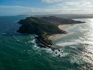
Cape Byron is the easternmost point of the mainland of Australia, located in New South Wales. It is about 3 km (1.9 mi) east of the town of Byron Bay, New South Wales and projects into the Pacific Ocean at 28.6335° S, 153.6383° E. A lighthouse is situated there. It is a popular area for hiking and for whale watching. Two national parks, one a conservation area and a marine park, are on the bay.

<span class="mw-page-title-main">Port Macquarie</span> Town in New South Wales, Australia

Port Macquarie is a coastal town in the local government area of Port Macquarie-Hastings. It is located on the Mid North Coast of New South Wales, Australia, about 390 km (242 mi) north of Sydney, and 570 km (354 mi) south of Brisbane. The town is located on the Tasman Sea coast, at the mouth of the Hastings River, and at the eastern end of the Oxley Highway (B56). The town with its suburbs had a population of 47,973 in June 2018.

<span class="mw-page-title-main">Northern Rivers</span> Region in New South Wales, Australia

Northern Rivers is the most north-easterly region of the Australian state of New South Wales, located between 590 and 820 kilometres north of the state capital, Sydney, and encompasses the catchments and fertile valleys of the Clarence, Richmond, and Tweed rivers. It extends from Tweed Heads in the north to the southern extent of the Clarence river catchment which lies between Grafton and Coffs Harbour, and includes the main towns of Tweed Heads, Byron Bay, Ballina, Kyogle, Lismore, Casino and Grafton. At its most northern point, the region is 102 kilometres (63 mi) south-southeast of the Queensland capital, Brisbane.

<span class="mw-page-title-main">Mullumbimby</span> Town in New South Wales, Australia

Mullumbimby is an Australian town in the Byron Shire in the Northern Rivers region of New South Wales. It promotes itself as "The Biggest Little Town in Australia". The town lies at the foot of Mount Chincogan in the Brunswick Valley about 9 kilometres by road from the coast. At the 2016 census, Mullumbimby and the surrounding area had a population of 3,596 people.

<span class="mw-page-title-main">Yamba, New South Wales</span> Town in New South Wales, Australia

Yamba is a town in northern New South Wales, Australia at the mouth of the Clarence River. The first European to visit the area was Matthew Flinders, who stopped in Yamba Bay for six days in July 1799.

<span class="mw-page-title-main">Newport, New South Wales</span> Suburb of Northern Beaches Council, New South Wales, Australia

Newport is a suburb of northern Sydney in the state of New South Wales, Australia, in the local government area of Northern Beaches Council. It is part of the Northern Beaches region.

<span class="mw-page-title-main">Terrigal, New South Wales</span> Suburb of Central Coast, New South Wales, Australia

Terrigal is a coastal town in the Central Coast of New South Wales, Australia, located 12 kilometres (7 mi) east of Gosford on the Pacific Ocean. It is part of the Central Coast Council local government area.

<span class="mw-page-title-main">Electoral district of Ballina</span> State electoral district of New South Wales, Australia

Ballina is an electoral district of the Legislative Assembly in the Australian state of New South Wales.

<span class="mw-page-title-main">Forster, New South Wales</span> Town in New South Wales, Australia

Forster is a coastal town in the Mid North Coast region of New South Wales, Australia, in the Mid-Coast Council LGA, about 308 km north-north-east of Sydney. It is immediately adjacent to its twin, Tuncurry, which is the smaller of the two towns. Forster is known for its stunning waters and Manning Valley beauty.

<span class="mw-page-title-main">Billinudgel, New South Wales</span> Town in New South Wales, Australia

Billinudgel is a town in the Northern Rivers region of New South Wales, Australia, and is part of Byron Shire. It used to be a railway town with many fruit and vegetables loaded onto the local railway. Since the railway is no longer used in Billinudgel, it has nearly joined to the nearby town of Ocean Shores. The area was bypassed by a heavily upgraded Pacific Highway in July 2007.

<span class="mw-page-title-main">Callala Bay</span> Town in New South Wales, Australia

Callala Bay is a small town on the South Coast of New South Wales, Australia in the City of Shoalhaven.

<span class="mw-page-title-main">Brunswick Heads</span> Town in New South Wales, Australia

Brunswick Heads is a small town on the north coast of New South Wales, Australia in Byron Shire. At the 2016 census, the town had a population of 1,737 people.

South Golden Beach is a coastal town in New South Wales, Australia in Byron Shire. It is off the Pacific Highway, close to Byron Bay, Ocean Shores, Billinudgel and the Queensland border. To the north of South Golden beach is Pottsville, and Brunswick heads to the south. At the 2006 census, South Golden Beach had a population of 1,729 people.

<span class="mw-page-title-main">Brunswick River (New South Wales)</span> River in New South Wales, Australia

Brunswick River is an open mature wave dominated barrier estuary, located in the Northern Rivers region of New South Wales, Australia.

The Rainforest Way is a circular series of tourist drives that extends through South East Queensland, Australia across the border into the Northern Rivers region of New South Wales.

<span class="mw-page-title-main">Scotts Head, New South Wales</span> Suburb of Nambucca Valley Council, New South Wales, Australia

Scotts Head is a coastal village of the Nambucca Valley local government area in the Mid North Coast region of New South Wales, Australia. Located on the coast of the Pacific Ocean, approximately 10 kilometres (6 mi) from the Pacific Highway and 480 kilometres (300 mi) from Sydney, it stretches southwards from just south of the mouth of the Nambucca River to the town of Scotts Head in the south.

The Mullumbimby Star was a newspaper published in Mullumbimby, New South Wales, Australia under various names from 1902 to 1982.

Cape Byron Marine Park is one of four marine parks in New South Wales, Australia, and is the most recently sanctioned. The Cape Byron Marine Park is located in Northern NSW and extends 37 kilometres (23 mi) from the Brunswick River to Lennox Head. The marine park extends out to 3 nautical miles which dictates the border between state and federal jurisdiction. The marine park covers an area of 220 square kilometres (85 sq mi) and includes a variety of marine terrain including beaches, rocky shores, open ocean and the tidal waters of the Brunswick River and its tributaries, the Belongil Creek and Tallow Creek. The Cape Byron Marine Park was declared in 2002 and the zoning plan was implemented in April 2006. Of the 15 distinct marine ecosystems identified within the Tweed-Moreton bioregion, the Cape Byron Marine Park supports 10 of these.

<span class="mw-page-title-main">Brunswick Valley Heritage Park</span>

Brunswick Valley Heritage Park, also known as Mullumbimby Heritage Park, is a rainforest arboretum and recreation park located on the banks of the Brunswick River in Mullumbimby, north-eastern New South Wales, Australia. Established in 1980, the arboretum has 300 species of local rainforest trees grown from seeds and cuttings collected from the surrounding forests. It is open every day of the year and access is free.

References

  1. 1 2 Australian Bureau of Statistics (27 June 2017). "Ocean Shores (State Suburb)". 2016 Census QuickStats. Retrieved 25 November 2017.
  2. 1 2 "Ocean Shores NSW | Official byronbay.com Guide". Byron Bay. Retrieved 21 May 2020.
  3. 1 2 "Ocean Shores". Visit North Coast NSW. Retrieved 10 October 2022.
  4. "Ocean Shores History · Ocean Shores Art Expo". Ocean Shores Art Expo. Retrieved 21 May 2020.
  5. "Ocean Shores climate: Average Temperature, weather by month, Ocean Shores water temperature - Climate-Data.org". en.climate-data.org. Retrieved 21 May 2020.
  6. "Climate History". www.meteorology.com.au. Retrieved 21 May 2020.
  7. "Ocean Shores". Byron and Beyond. Retrieved 21 May 2020.
  8. Echo, The (15 August 2018). "Ocean Shores school celebrates 25 years with time capsule". The Echo. Retrieved 10 October 2022.
  9. "2016 Ocean Shores, Census All persons QuickStats | Australian Bureau of Statistics". www.abs.gov.au. Retrieved 10 October 2022.
  10. "Byron Bay | History, Facts, & Points of Interest | Britannica". www.britannica.com. Retrieved 10 October 2022.
  11. "'Catastrophic failure': fury among NSW northern rivers locals 'forgotten' by authorities". the Guardian. 4 March 2022. Retrieved 10 October 2022.
  12. Shakeel, Muhammad. "New Brighton Farmers Market". The Official ByronBay.com Guide. Retrieved 10 October 2022.
  13. "Category Guidelines – Ocean Shores Art Expo". osartexpo.com. Retrieved 10 October 2022.
  14. "About · Ocean Shores Art Expo". Ocean Shores Art Expo. Retrieved 21 May 2020.
  15. "Ocean Shores Shopping Centre | ... just one stop!" . Retrieved 21 May 2020.
  16. "Get to know Cawarra Cosmetics". Your Site Title. Retrieved 10 October 2022.
  17. "Eco Friendly Packaging Australia". Green Pack. Retrieved 10 October 2022.
  18. "Contact The Sunglass Fix". www.thesunglassfix.com. Retrieved 10 October 2022.
  19. About Business Ashored
  20. "Home - Ocean Shores Country Club". oceanshorescc.com.au. Retrieved 10 October 2022.
  21. "Waterlily Park". www.byron.nsw.gov.au. Retrieved 10 October 2022.

Commons-logo.svg Media related to Ocean Shores, New South Wales at Wikimedia Commons