Byron Bay

Last updated

Byron Bay
Cavvanbah (Minjungbal)
New South Wales
Byron Bay Lighthouse, Beach and Hinterland in the Northern Rivers, NSW, Australia.jpg
Byron Bay, NSW (aerial shot showing Byron Bay's lighthouse, beaches and hinterland)
Australia New South Wales location map blank.svg
Red pog.svg
Byron Bay
Coordinates 28°38′35″S153°36′54″E / 28.64306°S 153.61500°E / -28.64306; 153.61500
Population6,330 (2021 census) [1]
Postcode(s) 2481
Elevation3 m (10 ft)
Location
LGA(s) Byron Shire
County Rous
State electorate(s) Ballina
Federal division(s) Richmond
Mean max tempMean min tempAnnual rainfall
23.5 °C
74 °F
16.9 °C
62 °F
1,509.2 mm
59.4 in

Byron Bay

Cape Byron Lighthouse Cape Byron Lighthouse from trail up.jpg
Cape Byron Lighthouse
Looking south from the lighthouse along Tallow Beach Byron Lighthouse looking south 2004-28-12.JPG
Looking south from the lighthouse along Tallow Beach
Wategos Beach with Julian Rocks out to sea Wategos.JPG
Wategos Beach with Julian Rocks out to sea
Byron Bay with sugar cane burning in the distance Byron Bay New South Wales.jpg
Byron Bay with sugar cane burning in the distance

Byron Bay (Minjungbal: Cavvanbah) is a beachside town located in the far-northeastern corner of New South Wales, Australia (in Bundjalung Country). It is located 772 kilometres (480 mi) north of Sydney and 165 kilometres (103 mi) south of Brisbane. Cape Byron, a headland adjacent to the town, is the easternmost point of mainland Australia. [2] At the 2021 census, the town had a permanent population of 6,330. [1] It is the largest town of Byron Shire local government area, though not the shire's administrative centre (which is Mullumbimby).

Contents

History

Byron Bay and surrounds are located on traditional lands of the Bundjalung Nation of the Arakwal, Minjungbal and the Widjabul people who have lived by the coast for at least 22,000 years. [3] Traditional custodians of the region believe that the land and people were created by Nguthungulli, who rests at what is now called Julian Rocks. [4] The traditional name of the township area was Cavvanbah, meaning "meeting place". [5] Significant totems for the area include Wajung and Kabul. [6]

In 1770 Lieutenant James Cook found safe anchorage and named Cape Byron after a fellow sailor Vice Admiral 'Foul-Weather Jack' John Byron, circumnavigator of the world and grandfather of the poet Lord Byron. [7] [8] European settlement in the area took place in the 1830s. A massacre took place in the 1850s, south of Suffolk Park where the quarry is today. [4]

The first industry in Byron was cedar logging from the Australian red cedar ( Toona ciliata ). The timber industry is the origin of the word "shoot" in many local names – Possum Shoot, Coopers Shoot and Skinners Shoot – where the timber-cutters would "shoot" the logs down the hills to be dragged to waiting ships. [9] Timber getting became insignificant after World War I. As a result, many former timber workers became farmers.

Gold mining of the beaches was the next industry to occur. Gold was discovered in Byron Bay in 1870. [10] Up to 20 mining leases set up on Tallow Beach to extract gold from the black sands around the 1870s.

Byron Bay has a history of primary industrial production (dairy factory, [11] abattoirs, fishing, and whaling until 1963) and was a significant, but hazardous, sea port. The poet Brunton Stephens spoke of cattle grazing on the "mossy plains" of Cape Byron in a poem he penned in 1876.

The first jetty was built in 1886, and the railway was connected in 1894, and Cavvanbah became Byron Bay in 1894. [12] Dairy farmers cleared more land and settled the area. In 1895, the Norco Co-operative was formed to provide cold storage and manage the dairy and processes meat industry. [12] [13] The introduction of paspalum grass improved production, and Byron Bay exported butter from its depots at Murwillumbah and Lismore to the world. [14]

The Cape Byron Lighthouse was built in 1901 at the most easterly point on the Australian mainland. [12] Its construction destroyed a significant Arakwal men's ceremonial ground. [4]

In 1930, the first meatworks opened. [12] The smell from the meat and dairy works was appalling and the annual slaughter of migrating whales in the 1950s and 1960s made matters worse. [15] Sand mining for monazite (zircon, uranium and thorium) between the World Wars damaged the environment further. [16] [17] [18] Mining ceased in 1968 and processing in 1972. [19]

Longboard surfers arrived in the 1960s and used natural breaks at The Pass, Watego's, and Cosy Corner. This was the beginning of Byron Bay as a travellers' destination, and by 1973, when the Aquarius Festival was held in nearby Nimbin, its reputation as a hippy, happy, alternative town was established, although tourism facilities remained minimal. [20] From the 1980s, tourism began to develop in earnest, with the cash-poor surfers and hippies supplemented, and to a degree supplanted, by cash-rich conspicuous consumers who in turn stimulated the development of retail precincts and accommodation more tuned to their needs.

In 1994, a native title claim was made by Arakwal Elders Lorna Kelly, Linda Vidler and Yvonne Graham. After seven years of negotiation, an Indigenous Land Use Agreement was formed with the State of New South Wales in 2001, a national first and precedent for subsequent agreements around Australia. Two further local agreements also followed. [21]

Today, Byron Bay is one of the most up-market residential areas on the Australian east coast with the growth in multi-million dollar mansions now pushing the median value of house sales up beyond AU$1.5 million in 2017, over a 100% increase since 2013, based on 2018 data from realestate.com.au. [22] At the same time, the town has not lost its attraction to a diverse range of visitors including surfers, backpackers and general tourists interested in the natural attractions of the area, and also supports a healthy cross section of creative persons including artists, craftspersons and musicians, while its more recent hippy/new age past is reflected to a degree in a prevalence of alternative "new-age" shops, "spiritual" services such as meditation and yoga classes, and holistic healing/"wellness" retreats. [23] As at 2018, the town is cited as having around 5,000 permanent residents, while being visited by 2 million tourists each year. [24]

A number of shipwrecks litter the bay and surrounding areas. [25] A total 16 are known with the most famous of these being the 'Wollongbar' which due to bad conditions sank off the eastern tip of Belongil beach, it now rests about 150 metres (490 ft) from the coast and is still visible above water during low tide. [26]

Heritage listings

Byron Bay has a number of heritage-listed sites, including:

Population

According to the 2021 census, there were 10,914 people in Byron Bay.

Historical population
YearPop.±%
19542,001    
19612,172+8.5%
19662,315+6.6%
19712,323+0.3%
19762,525+8.7%
19813,187+26.2%
19863,730+17.0%
19915,001+34.1%
19966,130+22.6%
20015,919−3.4%
20064,981−15.8%
20114,959−0.4%
20165,521+11.3%
20216,330+14.7%
Source: Australian Bureau of Statistics data. [31] [32] Note: data from 2016 counts Byron Bay as a State Suburb, not as an Urban Locality, and does not include the population of neighbouring community Suffolk Park.

Geology and Geography

Byron Bay is part of the erosion caldera of an ancient shield volcano, the Tweed Volcano, which had erupted 23 million years ago. The volcano formed as a result of the Indo-Australian Plate moving over the East Australia hotspot. [33] Although was named a Bay when discovered, it is in fact in geological terms a "Bight" as the angle of curvature from Cape Byron to Hastings point is less than 25 degrees. [34]

Climate

Byron Bay has a humid subtropical climate (Cfa in the Köppen climate classification) with warm summers and mild winters. Winters have daily maximums usually reaching 19.4 °C and a minimum of 12 °C. Summer can be hot, with a daily average of 27 °C. Summer evenings can be wet, cooling the day down. Due to its location on an ocean-facing cape, it is, therefore, more exposed to moist easterly flows, hence its annual rainfall above 1,500 mm, which is higher than that of Brisbane and the Gold Coast.

Climate data for Byron Bay (Cape Byron AWS, 2002–present)
MonthJanFebMarAprMayJunJulAugSepOctNovDecYear
Record high °C (°F)34.0
(93.2)
34.0
(93.2)
32.8
(91.0)
29.8
(85.6)
26.9
(80.4)
25.0
(77.0)
27.1
(80.8)
28.3
(82.9)
32.0
(89.6)
34.0
(93.2)
33.3
(91.9)
34.8
(94.6)
34.8
(94.6)
Mean daily maximum °C (°F)28.0
(82.4)
27.5
(81.5)
26.6
(79.9)
24.0
(75.2)
21.5
(70.7)
19.4
(66.9)
18.9
(66.0)
20.1
(68.2)
22.1
(71.8)
23.6
(74.5)
25.3
(77.5)
26.7
(80.1)
23.6
(74.5)
Mean daily minimum °C (°F)21.3
(70.3)
21.2
(70.2)
20.2
(68.4)
17.6
(63.7)
15.1
(59.2)
13.2
(55.8)
12.3
(54.1)
13.1
(55.6)
15.3
(59.5)
16.9
(62.4)
18.6
(65.5)
20.0
(68.0)
17.1
(62.8)
Record low °C (°F)16.5
(61.7)
16.0
(60.8)
14.7
(58.5)
10.9
(51.6)
9.0
(48.2)
6.5
(43.7)
7.1
(44.8)
6.6
(43.9)
9.7
(49.5)
9.5
(49.1)
11.8
(53.2)
13.9
(57.0)
6.5
(43.7)
Average rainfall mm (inches)164.4
(6.47)
166.6
(6.56)
142.1
(5.59)
183.5
(7.22)
99.4
(3.91)
164.9
(6.49)
96.3
(3.79)
75.4
(2.97)
47.0
(1.85)
95.8
(3.77)
93.4
(3.68)
139.3
(5.48)
1,509.2
(59.42)
Average precipitation days15.415.316.415.513.814.012.38.29.012.711.514.1158.2
Source: Bureau of Meteorology [35]
Belongil Beach Belongil Beach.jpg
Belongil Beach
Byron Bay Water Temperature
MonthJanFebMarAprMayJunJulAugSepOctNovDecYear
Average sea temperature °C (°F)27.1
(79.9)
28.1
(81.8)
27.8
(80.8)
26.5
(78.8)
25.7
(77.0)
24.1
(74.2)
22.8
(72.1)
22.6
(71.8)
22.9
(72.4)
25.2
(75.3)
26.0
(77.5)
22.9
(79.0)
24.1
(74.2)
Source #2: Metoc (sea temperature) [36]

Tourism

The main beach with Cape Byron in the distance, in 2006 Byron Bay (Australia) main Beach from town.JPG
The main beach with Cape Byron in the distance, in 2006
Cape Byron Lighthouse Byron Bay Lighthouse.JPG
Cape Byron Lighthouse

The town is a resort popular with both domestic and international tourists, not the least backpackers. It has several beaches that are popular for surfing and the scenery attracts skydivers. An oceanway allows visitors to walk and cycle from the centre of town to Cape Byron Lighthouse.

The area is noted for its wildlife, with whale watching a significant contributor to the local economy. [37] Temperate and tropical waters merge here, making it a popular place for scuba diving and snorkelling. Most diving is done at Julian Rocks, 2.5 kilometres from the town and part of the Cape Byron Marine Park. Subtropical rainforests are nearby, and areas such as the Nightcap National Park and its Minyon Falls are within easy reach of the town.

Byron Bay is a popular destination for Schoolies week during late November and early December. [38]

Events

Festivals held in or near Byron Bay include the East Coast Blues & Roots Music Festival at Tyagarah at Easter, Falls Festival NYE and Splendour in the Grass, the Byron Bay International Fashion Festival [39] on 29 April each year, the Byron Bay Writers Festival, [40] the Byron Bay Film Festival, Byron Bay Surf Festival, Byron Spirit Festival and the Byron Underwater Festival. [41] The Byron Bay Triathlon is held on the second Saturday in May every year; 1,300 competitors from many countries enter this Olympic Distance event. The vibrant musical community has produced internationally renowned bands such as Blue King Brown, Parkway Drive and 50 Lions.

Markets

Byron Bay has a number of regular markets including a weekly farmers' market [42] at the Cavanbah Centre every Thursday with over 70 local farmers selling fresh produce. There is also a Byron Community Market held on the same site on the first Sunday of each month and the Artisan Market held on Saturday evenings at Railway Park from October to Easter. There are three annual specialist Beachside Markets held in January, Easter and September. [43]

Transport

A bus interchange is located west of the old railway station along Butler Street and is served by Greyhound Australia, NSW TrainLink and Premier Motor Services coach services from Sydney and Brisbane.

The Byron Bay solar-powered-train was incorporated into a 1940's-era railmotor trainset Railmotor 726-661 stands at Byron Beach Platform, Byron Bay. 3-11-17.jpg
The Byron Bay solar-powered-train was incorporated into a 1940's-era railmotor trainset

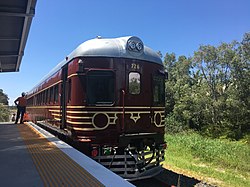
The privately run Byron Bay Train operates a shuttle service on a rehabilitated 3 km section of the disused Murwillimbah line between Byron Bay station in the Byron township and North Beach station, adjacent to the Elements of Byron resort. The service opened in December 2017, and uses an ex-NSWGR railmotor, converted to run exclusively on solar power using panels on top of the train and at the stations. [44] [45]

Until 2004, Byron Bay railway station was a stop on the Casino to Murwillumbah railway line. It was served by trains from Sydney and, for various periods, also by services originating at Casino that connected with expresses running between Sydney and South Brisbane.

An earlier local train service, known as the Byron Bay Tram conveyed passengers from about 1928 until about 1954 between the railway station and the "new jetty" where connections were made with passenger carrying ships of the North Coast Steam Navigation Company. Motive power was a Simplex petrol locomotive, locally known as the "Green Frog", and the passenger vehicles comprised former Newcastle B2 class steam tram trailer 74B and former Sydney C class electric tram C37. After the trams stopped running both the cars went to a heritage tramway in Parramatta Park where 74B was destroyed by fire. The Simplex was built in Bedford England and went into service in 1923 shunting freight to and from the "old" jetty adjacent to the township and then to "new" jetty to the north when it was completed in 1928. Later it hauled whales from the jetty to the rendering down works, livestock to the meat works, mineral sands and meat wagons to the station for onward movement and regularly shunted Norco and other railway sidings and between these duties ran the passenger tramway until the coastal passenger shipping service stopped. The Simplex locomotive was retired in 1984 when the meat works closed and is now stored in a shed near the Kendall Street level crossing under the care of volunteers and the Byron Bay Council.

Education

Byron Bay schools include Byron Bay Public School, Byron Bay High School, St Finbarr's Primary School, Byron Bay Community School, and Cape Byron Rudolf Steiner School. Among these are a number of early childhood facilities including Byron Bay Preschool and Periwinkle Preschool. In the fields of adult education, there are Lexis English Centres and Lexis Training (previously Global Village English Centres), the Byron Region Community College, which is a registered training organisation and the SAE Institute Byron Bay which is a government-accredited, degree-granting institution in the fields of audio engineering, digital film making, multimedia and animation.

Sport and recreation

The Byron Bay Surf Club is the longest-standing current sports club; it has been one of Australia's leading surf clubs and has been in continuous operation for more than 105 years. The rugby league club the Byron Bay Red Devils and the Australian rules football team Byron Magpies are well known.

Byron Bay FC has won 14 top grade honours in Football Far North Coast competitions including 4 ANZAC Cups (2003, 2004, 2007 and 2017), 5 premierships (2006, 2014, 2015, 2017 and 2019) and 5 Cyril Mayo Cups for winning the grand final (2005, 2006, 2013, 2017 and 2018). Byron Bay was created as a junior club in 1963 and formed their first senior team in 1966. [46] In 1982 Byron Bay joined Lismore & District Soccer Association competitions. [46] In 2017 Byron Bay became one of only 5 clubs to win the treble (ANZAC Cup, premiership and Cyril Mayo Cup) in the same season, and became the first, and so far only club to win the treble and Summer Youth League (which began in 2008).

Other clubs include Byron Bay Golf Club, Byron Bay Cricket Club, Byron Bay Rugby Union Club, Byron Bay Gliding Club, Byron Bay Hang Gliding / Paragliding Club and the Byron Bay Bowling Club.

The Byron Bay Ocean Swim Classic is held every year.

Media

The Byron Bay area has a number of newspapers:

The community radio station Bay FM broadcasts on 99.9 FM from within Byron Bay itself. Other local stations in the Byron area are:

All major television channels are available in Byron Bay and the wider Northern Rivers region:

Notable people

Byron Bay viewed from the Cape Byron walking track Bryon Bay NSW.jpg
Byron Bay viewed from the Cape Byron walking track

Notable people from or who have lived in Byron Bay include:

In fiction

John Macgregor's 1986 novel Propinquity is partly set in Byron Bay and nearby Mullumbimby. The 2008/2009 ABC drama series East of Everything , written by Deb Cox and Roger Monk, is set in the fictional town of Broken Bay which is based on a somewhat more run-down version of Byron Bay and its surrounds, with much of the filming taking place in and around Byron Bay including obviously recognisable landmarks such as the lighthouse and local beaches. Parts of the 2014 film The Inbetweeners 2 take place in Byron Bay. The town also features in the 2016 open world racing video game, Forza Horizon 3 and is where the Horizon Byron Bay Festival is situated. In July 2019 Byron Bay was used in Neighbours for the return storyline for Dee Bliss.

The driver's license of Zak in Fern Gully (1992) indicates that he resides in Byron Bay, suggesting that the plot of the movie occurs in Australia.

Related Research Articles

<span class="mw-page-title-main">Coffs Harbour</span> City in New South Wales, Australia

Coffs Harbour, locally nicknamed Coffs, is a coastal city on the Mid North Coast of New South Wales, Australia, 540 km (340 mi) north of Sydney, and 390 km (240 mi) south of Brisbane. It is one of the largest urban centres on the North Coast, with a population of 78,759 as per 2021 census. The Gumbaynggirr are the original people of the Coffs Harbour region.

<span class="mw-page-title-main">Central Coast (New South Wales)</span> Region in New South Wales, Australia

The Central Coast is a peri-urban region lying on the Pacific Ocean in northern-eastern New South Wales, Australia. The region is situated north of Sydney, which is filled with subtropical national parks, forests and also encompasses the major coastal waterways of Brisbane Water, Tuggerah Lakes and southern Lake Macquarie. The region's hinterland, which has fertile valleys, rural farmland and wineries, and also includes the Watagan Mountains. The Central Coast is known for its regional coastal towns like Terrigal, The Entrance, Ettalong Beach, Budgewoi and Bateau Bay with resorts and holiday parks, which feature many expansive beaches and lagoons with surfing and coastal tracks, as well as scenic views. Gosford is the main commercial hub and gateway.

<span class="mw-page-title-main">Batemans Bay</span> Town in New South Wales, Australia

Batemans Bay is a town on the South Coast region of the state of New South Wales, Australia. Batemans Bay is administered by the Eurobodalla Shire council. The town is situated on the shores of an estuary formed where the Clyde River meets the southern Pacific Ocean.

<span class="mw-page-title-main">Parkes, New South Wales</span> Town in New South Wales, Australia

Parkes is a town in the Central West region of New South Wales, Australia. It is the main settlement in the local government area of Parkes Shire. Parkes has a population of 10,919 at the 2021 census.

<span class="mw-page-title-main">Ballina, New South Wales</span> Town in New South Wales, Australia

Ballina is a town in the Northern Rivers region of New South Wales, Australia, and the seat of the Ballina Shire local government area. It lies 740 km (460 mi) north of Sydney and 185 km (115 mi) south of Brisbane. Ballina's urban population at the end of 2021 was 46,190. The town lies on the Richmond River and serves as a gateway to Byron Bay.

<span class="mw-page-title-main">Sutherland Shire</span> Local government area in New South Wales, Australia

Sutherland Shire is a local government area in the southern region of Sydney, in the state of New South Wales, Australia. The Sutherland Shire is located just south of the Sydney CBD, and comprises an area of 370 square kilometres (140 sq mi) and as at the 2016 census and has an estimated population of 218,464. The Sutherland Shire is colloquially known as "The Shire" which has been featured in several reality television series.

<span class="mw-page-title-main">Tweed Heads, New South Wales</span> Town in New South Wales, Australia

Tweed Heads is a coastal city at the mouth of the Tweed River in the Northern Rivers region of the state of New South Wales, Australia. Tweed Heads is the northernmost town in New South Wales, and is located in the Tweed Shire local government area. It is situated 830 km (520 mi) north of Sydney and 103 km (64 mi) south of Brisbane. The town is next to the border with Queensland and is adjacent to its "twin town" of Coolangatta, which is a suburb of the Gold Coast in Queensland.

<span class="mw-page-title-main">Busselton</span> City in the South West region of Western Australia

Busselton is a city in the South West region of the state of Western Australia approximately 220 km (140 mi) south-west of Perth. Busselton has a long history as a popular holiday destination for Western Australians; however, the closure of the Busselton Port in 1972 and the contemporaneous establishment of the nearby Margaret River wine region have seen tourism become the dominant source of investment and development, supplemented by services and retail. The city is best known for the Busselton Jetty, the longest wooden jetty in the Southern Hemisphere.

<span class="mw-page-title-main">Mullumbimby</span> Town in New South Wales, Australia

Mullumbimby is a town in the Byron Shire in the Northern Rivers region of New South Wales, Australia. It promotes itself as "The Biggest Little Town in Australia". The town lies at the foot of Mount Chincogan in the Brunswick Valley about 9 kilometres by road from the coast. At the 2021 census, Mullumbimby and the surrounding area had a population of 3,589 people. It was first inhabited by Indigenous Australian peoples.

Splendour in the Grass is an annual Australian music festival held at the North Byron Parklands in Yelgun, New South Wales. Since its inauguration, the festival has also been held in various locations near Byron Bay, New South Wales, and Woodford, Queensland.

<span class="mw-page-title-main">Moss Vale</span> Town in New South Wales, Australia

Moss Vale is a town in the Southern Highlands of New South Wales, Australia, in the Wingecarribee Shire. It is located on the Illawarra Highway, which connects to Wollongong and the Illawarra coast via Macquarie Pass.

<span class="mw-page-title-main">Arakwal National Park</span> Protected area in New South Wales, Australia

Arakwal National Park is a national park in New South Wales, Australia, 624 km north of Sydney and immediately south of Cape Byron, the most easterly point of mainland Australia. The park protects an area of Wallum country, of coastal clay heaths, between the adjacent town of Byron Bay and east-facing Tallow Beach. It provides habitat to numerous bird species and two native frog species, the Wallum Froglet and Wallum Sedge Frog, both of which are deemed vulnerable to extinction.

<span class="mw-page-title-main">Murwillumbah railway line</span> Former railway line in New South Wales

The Murwillumbah railway line is a mostly disused railway line in far north-eastern Northern Rivers New South Wales, Australia. The line ran from Casino to Lismore, Byron Bay, Mullumbimby and Murwillumbah, opening in 1894. It is one of only two branches off the North Coast line,. Train services to the region ceased in May 2004. The line from Casino to Bentley and Murwillumbah to Crabbes Creek was formally closed on 23 September 2020 to facilitate the construction of a rail trail.

<span class="mw-page-title-main">Bundjalung people</span> Aboriginal Australian people of New South

The Bundjalung people, also spelled Bunjalung, Badjalang and Bandjalang, are Aboriginal Australians who are the original custodians of a region from around Grafton in northern coastal New South Wales to Beaudesert in south-east Queensland. The region is located approximately 550 kilometres (340 mi) northeast of Sydney and 100 kilometres (62 mi) south of Brisbane that now includes the Bundjalung National Park.

<span class="mw-page-title-main">Scotts Head, New South Wales</span> Suburb of Nambucca Valley Council, New South Wales, Australia

Scotts Head is a coastal village of the Nambucca Valley local government area in the Mid North Coast region of New South Wales, Australia. Located on the coast of the Pacific Ocean, approximately 10 kilometres (6 mi) from the Pacific Highway and 480 kilometres (300 mi) from Sydney, it stretches southwards from just south of the mouth of the Nambucca River to the town of Scotts Head in the south.

<span class="mw-page-title-main">Byron Bay High School</span> Secondary school in Byron Bay, Australia

Byron Bay High School is a government-funded co-educational comprehensive secondary day school, located in Byron Bay, New South Wales, Australia. The school, which is designed in the shape of a nautilus shell, opened on 15 May 1987. Facilities of the school include: agriculture centre, basketball courts, canteen, car park, changing rooms, library, multi-purpose centre, performing arts centre, sports centre and sports pitch. The indignous country land the school was built on was Arakwal people of the Bundjalung nation.

<span class="mw-page-title-main">Cape Byron Light</span> Lighthouse in New South Wales, Australia

Cape Byron Light, also called Cape Byron Lightstation, is an active heritage-listed lighthouse and now interpretative centre, interpretative space, maritime museum, administration office, retail building, accommodation, tourist attraction and visitor attraction located at Lighthouse Road, Byron Bay, Cape Byron, Byron Shire, New South Wales, Australia. It was designed by Charles Harding and Cecil W. Darley and built from 1899 to 1901 by Messrs Mitchell & King. It is also known as Cape Byron Lightstation, Byron Bay Lighthouse, Cape Byron Headlan and Cape Byron Headland Reserve. The property is owned by NSW National Parks & Wildlife Service.

<span class="mw-page-title-main">Jan Barham</span> Member of the New South Wales Legislative Council

Janette Louise Barham is an Australian politician who was a member of the New South Wales Legislative Council between 2011 and 2017.

<span class="mw-page-title-main">Byron Bay railway station</span> Former railway station in New South Wales,

Byron Bay railway station is a former railway station located on the Murwillumbah line in Byron Bay, New South Wales, Australia. It opened on 15 May 1894 and closed on 16 May 2004, when the line from Casino was closed. The station complex was built from 1894 to 1913. The property was added to the New South Wales State Heritage Register on 2 April 1999.

<span class="mw-page-title-main">Broken Head, New South Wales</span> Place in New South Wales, Australia

Broken Head is a coastal feature (promontory/headland) and suburb located in the Northern Rivers region of New South Wales, Australia, approximately 9 km south of Cape Byron, the easternmost point of Australia, the closest town being Byron Bay. Immediately adjacent is the 98-hectare (240-acre) Broken Head Nature Reserve which contains an intact segment of littoral rainforest. The suburb of Broken Head contained a population of 225 at the 2011 national census, and in addition supports some tourist accommodation and a campsite. The area is noted for its Aboriginal culture, rainforest walks, whale watching and fishing from pristine beaches, and it is also highly regarded as a surfing locality. The Broken Head Holiday Park is currently administered by the indigenous Arakwal people, having been passed to their control by the New South Wales Crown Lands Department in 2009.

References

  1. 1 2 Australian Bureau of Statistics (28 June 2022). "Byron Bay". 2021 Census QuickStats. Retrieved 20 August 2022. OOjs UI icon edit-ltr-progressive.svg CC-BY icon.svg Material was copied from this source, which is available under a Creative Commons Attribution 4.0 International License Archived 16 October 2017 at the Wayback Machine .
  2. "Most Easterly Point In Mainland Australia | Byron Bay | Australia | AFAR". www.afar.com. 27 May 2015. Retrieved 18 May 2020.
  3. "Aboriginal cultural heritage". www.byron.nsw.gov.au. Retrieved 15 July 2021.
  4. 1 2 3 "Arakwal People of Byron Bay" . Retrieved 15 July 2021.
  5. "Aboriginal elders gather at historic meeting place". The Newcastle Herald . Archived from the original on 24 March 2014. Retrieved 16 May 2013.
  6. "Arakwal People of Byron Bay » Glossary" . Retrieved 15 July 2021.
  7. Watson, Penny (November 2009). "New South Wales". In Vaisutis, Justine (ed.). Lonely Planet: Australia (15 ed.). Lonely Planet Publications. p. 195. The Grandfather of the [...] poet Lord Byron was a renowned navigator in the 1760s, and Captain Cook named this spot after [...] him. (In the 1880s, when Europeans settled more permanently, streets were named for other English writers and philosophers. A star-struck clerk in Sydney thought the grandson was the one being honoured, and named the streets – and the town – after poets: Keats, Jonson, Shelley.)
  8. "Byron Bay". Geographical Names Register (GNR) of NSW. Geographical Names Board of New South Wales . Retrieved 28 June 2009. OOjs UI icon edit-ltr-progressive.svg
  9. "Byron Bay Historical Society: Early Settlement". 19 June 2014. Archived from the original on 15 August 2018. Retrieved 27 August 2018.
  10. Graham, Bruce (2004). The Green Coast: The Natural Environment of the Tweed-Moreton Bioregion. Tweed Heads, New South Wales. p. 118. ISBN   0-9751817-0-X.{{cite book}}: CS1 maint: location missing publisher (link)
  11. Creamery Tramway at Byron Bay Longworth, Jim Australian Railway Historical Society Bulletin, October 1996, pp. 295–298.
  12. 1 2 3 4 "Beauty and the beast". The Sydney Morning Herald. 20 March 2005. Archived from the original on 10 April 2008. Retrieved 7 October 2008.
  13. "NORCO". Archived from the original on 12 October 2008. Retrieved 7 October 2008.
  14. "Norco - Our History". www.norco.com.au. Retrieved 15 July 2021.
  15. Martyn, Stephen (24 March 2015). "Byron Bay's beef and whale tale". Farm Online. Retrieved 15 July 2021.
  16. Cumbebin swamp nature reserve Archived 25 June 2014 at the Wayback Machine National Parks and Wildlife Service (New South Wales) page 20
  17. "Industry". 19 June 2014. Archived from the original on 10 March 2017. Retrieved 28 September 2017.
  18. "Newrybar (Record #514 rare-earth element deposit in New South Wales, Australia". mrdata.usgs.gov. Archived from the original on 29 September 2017. Retrieved 28 September 2017.
  19. "Site 7: Sand Mining". Byron Bay Historical Society. 14 August 2020. Retrieved 15 July 2021.
  20. Catriona Elder; Keith Moore, eds. (2012). New Voices, New Visions: Challenging Australian Identities and Legacies. Cambridge Scholars Publishing. pp. 55–63. ISBN   978-1-4438-3756-9. Archived from the original on 29 September 2017. Retrieved 28 September 2017.
  21. "Arakwal People of Byron Bay» Native Title & Indigenous Land Use Agreements" . Retrieved 15 July 2021.
  22. realestate.com.au data for Byron Bay, NSW Archived 27 August 2018 at the Wayback Machine (retrieved 27 August 2018)
  23. Wray, Meredith, Laing, Jennifer and Voigt, Cornelia. 2010. "Byron Bay: an alternate health and wellness destination." Journal of Hospitality and Tourism Management Volume 17, Issue 1, Pages 158-166. DOI:10.1375/jhtm.17.1.158
  24. Destination Byron: Our Shire Archived 28 August 2018 at the Wayback Machine (entry for Byron Bay)
  25. NSW Heritage office: "Shipwrecks - Byron Bay." Available online at https://www.environment.nsw.gov.au/resources/heritagebranch/maritime/shipwrecksbyron.pdf
  26. Byron Bay Historical Society "Site 16 : Shipwrecks" Available online at https://www.https Archived 19 August 2013 at the Wayback Machine ://byronbayhistoricalsociety.org.au/history-trail/shipwrecks/>byronbayhistoricalsociety.org.au/history-trail/shipwrecks/
  27. "Byron Bay Railway Station and yard group". New South Wales State Heritage Register . Department of Planning & Environment. H01107. Retrieved 18 May 2018. CC BY icon.svg Text is licensed by State of New South Wales (Department of Planning and Environment) under CC-BY 4.0 licence .
  28. "Byron Bay Post Office (Place ID 106175)". Australian Heritage Database . Australian Government . Retrieved 15 September 2018.
  29. "Cape Byron Lightstation (including moveable items)". New South Wales State Heritage Register . Department of Planning & Environment. H02023. Retrieved 18 February 2020. CC BY icon.svg Text is licensed by State of New South Wales (Department of Planning and Environment) under CC-BY 4.0 licence .
  30. "2021 Byron Bay, Census All persons QuickStats | Australian Bureau of Statistics". www.abs.gov.au. Retrieved 27 May 2023.
  31. "Statistics by Catalogue Number". Australian Bureau of Statistics. Retrieved 8 January 2024.
  32. "Search Census data". Australian Bureau of Statistics. Retrieved 8 January 2024.
  33. "The Lost World". Big Volcano Visitor Guide. Archived from the original on 14 March 2013. Retrieved 19 January 2013.
  34. "Bay, Bight, Fjord, and Sound: Similarities and Differences Between These Coastal Features". 25 April 2017.
  35. "Cape Byron AWS". Climate statistics for Australian locations. Bureau of Meteorology . Retrieved 23 April 2016.
  36. "Byron Bay Sea Temperature". World sea temperature. Retrieved 8 January 2019.
  37. "Byron Bay". Visit NSW. Archived from the original on 8 December 2012. Retrieved 19 January 2013.
  38. "Byron Bay Schoolies 'put Gold Coast to shame'". Brisbane Times. 30 November 2009. Archived from the original on 3 December 2009. Retrieved 29 July 2010.
  39. "Byron Bay Fashion Festival". Archived from the original on 13 September 2017. Retrieved 22 September 2017.
  40. "Byron Bay Writers' Festival". Northern Rivers Writers' Centre. Archived from the original on 14 January 2013. Retrieved 19 January 2013.
  41. "Welcome to the Underwater Festival 2012". Underwater Australasia. Archived from the original on 2 March 2013. Retrieved 19 January 2013.
  42. "Byron Farmers' Market". Archived from the original on 13 August 2011. Retrieved 19 January 2013.
  43. "Byron Markets". Byron Community Centre. Archived from the original on 15 December 2014. Retrieved 15 December 2014.
  44. "The World's First Solar-Powered Train Heads to Byron Bay". Broadsheet. Archived from the original on 29 October 2017. Retrieved 29 October 2017.
  45. "Byron Bay Train". Byron Bay Railroad Co Ltd. Retrieved 10 February 2019.
  46. 1 2 "About the club — byron bay fc". Archived from the original on 11 August 2019. Retrieved 11 August 2019.
  47. "For Camille Barr, transitioning from poetry to music was a natural progression". Beat Magazine. 20 September 2019. Retrieved 16 June 2020.
  48. Plaque on a memorial to Bill Clifford in front of Byron Bay railway station; A Few Geraniums, the story of Elizabeth Smith Beryl Moore 2009
  49. Cornell. Delaney sell up Byron properties Archived 26 December 2014 at the Wayback Machine The Northern Star 11 December 2012.
  50. "The Block's Shelley Craft's renovated Byron Bay home". Homes To Love. Retrieved 18 March 2019.
  51. http://www.dailytelegraph.com.au/entertainment/sydney-confidential/chris-hemsworth-has-been-brutally-honest-about-hollywood-and-his-hatred-of-paparazzi-in-gq-interview/story-fni0cvc9-1227184955180 The Daily Telegraph 15 January 2015.
  52. Macken, Lucy (2021). "Little-known billionaire buys a $9.4m Southern Highlands farm". Australian Financial Review. Archived from the original on 15 December 2021.
  53. Chancellor, Jonathan (2022). "From Bondi to Byron: Celebrity nutritionist Simon Hill's huge real estate spend". Real Estate. Archived from the original on 11 February 2024.
  54. Who owns Hoges' house now? Archived 26 December 2014 at the Wayback Machine The Northern Star 2 October 2012.
  55. "Andy Holm". Daily Telegraph. Retrieved 18 December 2022.
  56. Archived at Ghostarchive and the Wayback Machine : "LiUNA! Bluesfest Windsor Presents: YUNITY Ft. Jeff Martin of The Tea Party". YouTube .
  57. "Pauline Menczer Biography and Photos | SURFLINE.COM". www.surfline.com. Retrieved 17 June 2020.
  58. Dobson, Jim. "Inside Olivia Newton-John's Stunning Gaia Health Retreat & Spa In Australia". Forbes. Retrieved 18 March 2019.
  59. Kerry O'Brien Archived 25 December 2014 at the Wayback Machine The Weekly Review 11 August 2011.
  60. "Star Stuff (YouTube channel)". YouTube . Retrieved 8 July 2022.
  61. Pentelow, Orla (9 May 2017). "Boyeurism: Parcels". Vogue. Archived from the original on 1 December 2017. Retrieved 12 January 2018.
  62. "Kieren Perrow Wins The Pipe Masters". SURFER Magazine. 11 December 2011. Retrieved 16 June 2020.
  63. "Breaking: Kieren Perrow Steps Down as WSL Commissioner!". Tracks. 12 February 2019. Retrieved 16 June 2020.
  64. Ric Richardson Archived 12 July 2015 at the Wayback Machine The Sydney Morning Herald, 22 April 2014.
  65. "Taylor Steele". map magazine // THE DREAMERS. 7 December 2012. Retrieved 16 June 2020.
  66. "Professional surfing days over for Danny". Byron Shire News. Retrieved 17 June 2020.
  67. Pentelow, Orla (9 May 2017). "Boyeurism: Parcels". Vogue . Condé Nast. Archived from the original on 20 May 2017. Retrieved 30 April 2020.
  68. Burmester, Jann (1 August 2012). "Cleo steps up". Byron Shire News. News Corp Australia . Retrieved 30 April 2020.