
The Gold Coast is a coastal city in the Australian state of Queensland, approximately 66 kilometres (41 mi) south-southeast of the centre of state capital Brisbane and immediately north of the border with New South Wales. The demonym for the Gold Coast is Gold Coaster. With an estimated population of 679,127, at June 2019, the Gold Coast is the sixth-largest city in Australia, making it the largest non-capital city, and Queensland's second-largest city.

The Tweed River is a river situated in the Northern Rivers district of New South Wales, Australia. It has a mature wave dominated, barrier estuary. From the middle reaches of its course, the state boundary between New South Wales and Queensland is located approximately 10 kilometres (6.2 mi) north of the Tweed River.
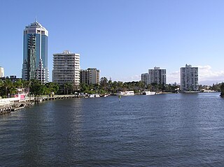
The Nerang River is a perennial river located in South East Queensland, Australia. Its catchment lies within the Gold Coast local government area and covers an area of 490 square kilometres (190 sq mi). The river is approximately 62 kilometres (39 mi) in length.

Coolangatta is a coastal suburb and the southernmost suburb of City of Gold Coast, Queensland, Australia. It borders New South Wales. It is named after the schooner Coolangatta which was wrecked there in 1846. At the 2016 census, the suburb recorded a population of 5,948.

Currumbin is a coastal suburb in the City of Gold Coast, Queensland, Australia. In the 2016 census, Currumbin had a population of 2,920 people.

Palm Beach is a coastal suburb in the City of Gold Coast, Queensland, Australia. In the 2016 census, Palm Beach had a population of 14,654 people.
The Gold Coast Oceanway is a policy on hard infrastructure foreshoreway along dunes Gold Coast, Queensland. The Gold Coast Oceanway is a shared use pedestrian and cyclist pathway on the Gold Coast, connecting the Point Danger lighthouse on the New South Wales and Queensland border to the Gold Coast Seaway. The network includes 36 kilometres (22 mi) of poor, medium and high quality pathways.

Currumbin Wildlife Sanctuary is a heritage-listed zoological garden at 28 Tomewin Street, Currumbin, Queensland, Australia. It was built in 1947 onwards. It was added to the Queensland Heritage Register on 18 September 2009. The sanctuary is world-renowned for its feeding of huge flocks of free-flying wild rainbow lorikeets, which come to the sanctuary to feast off the special mixture which the lorikeets eat.

Snapper Rocks is a small rocky outcrop on the northern side of Point Danger at the southern end of Rainbow Bay on the Gold Coast, Queensland, Australia. It is a famous surf break and today the start of the large sand bank known to surfers as the Superbank.

Tamarindo is a town and district of the Santa Cruz canton, located on the Nicoya Peninsula on the Northern Pacific coast of Costa Rica in the Province of Guanacaste. The town of Tamarindo is the largest developed beach town in Guanacaste and the district has a population of 6,375 as of 2011. Main attractions in the area are surfing and eco-tourism.

Tugun is a beach-side coastal suburb of the City of Gold Coast, Queensland, Australia. It borders New South Wales. At the 2016 census, Tugun had a population of 6,588.
The Coolangatta Gold is one of the premier events in the sport of Ironman. The event is organised by Surf Life Saving Australia.
Sport on the Gold Coast has a rich history. As a popular tourist destination leisure sports like Golf, but most particularly sports associated with its famous beaches, have always been popular. A number of surf clubs line Gold Coasts beaches, who host a variety of swimming and athletic events collected into surf carnivals along with competitions evolved from methods of surf life saving.

Breamlea, Victoria, Australia, is a secluded seaside hamlet located on the south coast of the Bellarine Peninsula, 18 kilometres south of Geelong and halfway between Barwon Heads and Torquay. It is divided between the City of Greater Geelong and the Surf Coast Shire. In the 2016 census, Breamlea had a permanent population of 162.
The Gold Coast Shoreline Management Plan (GCSMP) is an ICZM plan to manage the coastal resources of City of Gold Coast. The EPA encourages the City Council's to produce shoreline management plans for coastlines and tidal waterways within the local authority area.

The Gold Coast Highway in Queensland, Australia links the coastal suburbs of the Gold Coast such as Miami, Mermaid Beach, Tugun, Bilinga and the Tweed Heads suburb of Tweed Heads West. 39.8 kilometres (24.7 mi) in length, the highway runs from near the Pacific Motorway at Pacific Pines to the Pacific Motorway at Tweed Heads. It passes through the numerous popular tourist areas including Surfers Paradise and Broadbeach, a commercial centre at Southport, residential areas, shopping centres and the Gold Coast (Coolangatta) Airport.

The Tallebudgera Creek is a creek located in South East Queensland, Australia. Its catchment lies within the Gold Coast local government area and covers an area of 98 square kilometres (38 sq mi). The river is approximately 25 kilometres (16 mi) in length and is known for good fishing.

The Currumbin Creek is a creek located in South East Queensland, Australia. Its catchment lies within the Gold Coast local government area and covers an area of 489 square kilometres (189 sq mi). The river is approximately 24 kilometres (15 mi) in length and provides a popular and tranquil setting for many rowing clubs, kayakers, jet skiers, boat-goers and fishermen.
Wayne "Rabbit" Bartholomew is an Australian world champion surfer, surf sports innovator, community advocate and politician. Bartholomew is the former CEO and President of the Association of Surfing Professionals and the creator of the Dream Tour format of professional competition surfing.
Duranbah Beach, officially known as Flagstaff Beach, is the northernmost beach in New South Wales. Located in the Tweed Shire, Duranbah Beach is situated between the mouth of the Tweed River and the rocky headland Point Danger which also marks the Queensland-New South Wales border. The beach is 350 meters in length with vegetated dunes running along 200 meters. The southern end of the beach features BBQs, sheltered picnic areas and a block of toilets with a shower just behind it.
