Related Research Articles

A cable ferry is a ferry that is guided across a river or large body of water by cables connected to both shores. Early cable ferries often used either rope or steel chains, with the latter resulting in the alternative name of chain ferry. Both of these were largely replaced by wire cable by the late 19th century.

The Hawkesbury River, or Hawkesbury-Nepean River, is a river located northwest of Sydney, New South Wales, Australia. The Hawkesbury River and its associated main tributary, the Nepean River, almost encircle the metropolitan region of Sydney. Between Wisemans Ferry and the Pacific Ocean marks the boundary of Greater Metropolitan Sydney in the south and the Central Coast region to the north.

The Colo River, a perennial stream that is part of the Hawkesbury-Nepean catchment, is located in the Central Tablelands of New South Wales, Australia.

Brooklyn is a suburb and the northern most town on the Pacific Highway in Sydney, New South Wales, Australia. Brooklyn is located on the northern outskirts of Sydney and is located in the local government area of the Hornsby Shire with a population of 737 as of the 2021 census. Brooklyn is surrounded by the Muogamarra Nature Reserve and occupies a strip of waterfront along the southern bank of the Hawkesbury River.

The Roads & Traffic Authority (RTA) was an agency of the Government of New South Wales responsible for major road infrastructure, licensing of drivers, and registration of motor vehicles. The RTA directly managed state roads and provided funding to local councils for regional and local roads. In addition, with assistance from the federal government, the RTA also managed the NSW national highway system. The agency was abolished in 2011 and replaced by Roads & Maritime Services.

Sackville North is a suburb of Sydney, in the state of New South Wales, Australia 80 kilometres north-west of the Sydney central business district in the local government area of The Hills Shire.
Lower Portland is a rural suburb near Sydney, in the state of New South Wales, Australia. Lower Portland is located 80 kilometres northwest of the Sydney central business district, in the local government areas of The Hills Shire (east of the Hawkesbury River and the City of Hawkesbury. Lower Portland is a peaceful hamlet located at the junction of the Colo and Hawkesbury rivers. The area has historical significance, is scenic and is popular for water skiing.

Wisemans Ferry is a town on the northern outskirts of Sydney and the south-west of the Central Coast region in the state of New South Wales, Australia, located 75 kilometres north north-west of Sydney. It is located in the Sydney local government areas of the Hornsby Shire, The Hills Shire, City of Hawkesbury and the Central Coast Council. The town is a tourist spot with picnic and barbecue facilities. As well as a rich convict and colonial heritage in the area, the Dharug National Park and Yengo National Park are close by.
Wisemans Ferry is a cable ferry across the Hawkesbury River in New South Wales, Australia. The ferry operates from the eponymous community of Wisemans Ferry on the south bank, to a point on the north bank downstream of the Hawkesbury River's confluence with the Macdonald River, connecting with the old Great North Road. The crossing has remained in use on its current site since 1829, making it the oldest ferry crossing still in operation in New South Wales, and possibly in Australia.

Transport in Sydney is provided by an extensive network of public transport operating modes including metro, train, bus, ferry and light rail, as well as an expansive network of roadways, cycleways and airports. According to the 2006 census, in terms of travel to work or study Sydney has the highest rate of public transport usage among the Australian capital cities of 26.3% with more than 80% of weekday trips to/from Central Sydney being made by public transport. According to the New South Wales State Plan, the state has Australia's largest public transport system. The public transport network is regulated by Transport for NSW.

Mooney Mooney is a small waterfront village and suburb of the Central Coast region of New South Wales, Australia. It is located in the Central Coast Council local government area at the end of a peninsula extending southwards into the Hawkesbury River, that is situated 50 kilometres (31 mi) north of Sydney. Mooney Mooney has two islands which are Peat Island and Spectacle Island.
The Mortlake Ferry, also known as the Putney Punt, is a cable ferry that runs across the Parramatta River in Sydney, connecting Hilly Street in Mortlake and Pellisier Road in Putney.

Sackville (Doorumbolooa) is a suburb of Sydney, in the state of New South Wales, Australia. It is located in the City of Hawkesbury and at the 2016 census had a population of 298, thirteen of whom identified as Aboriginal and Torres Strait Islander.

The Kurrajong railway line was a railway line in the distant rural western suburbs of Sydney, Australia. It was an extension of the branch off the Main Western line from Blacktown to Richmond and was operated by the New South Wales Government Railways.

The Sackville Ferry is a cable ferry across the Hawkesbury River in New South Wales, Australia. The vehicular ferry connects the communities of Sackville, on the north/west bank of the river, and Sackville North, on the south/east bank. Because of the tortuous course of the river, the ferry actually runs north-west from Sackville to Sackville North.

Webbs Creek Ferry is a cable ferry across the Hawkesbury River in New South Wales, Australia. The ferry operates from the community of Wisemans Ferry, to a point up-stream of the Hawkesbury River's confluence with the Macdonald River, thus connecting with St Albans Road that follows the west bank of the Macdonald River.

The Berowra Waters Ferry is a cable ferry across the Berowra Creek, a tributary of the Hawkesbury River, located in the Berowra Valley National Park, Sydney, Australia. The ferry operates from the community of Berowra Waters on the west bank of the creek, to a landing on the east bank, thus connecting with the road to Berowra Heights.

The Peats Ferry Bridge is a steel truss bridge that carries the Pacific Highway (B83) across the Hawkesbury River, between Kangaroo Point and Mooney Mooney Point, located 40 kilometres (25 mi) north of Sydney in New South Wales, Australia. The bridge carries the Hornsby to Kariong section of highway, while the adjacent Brooklyn Bridge carries the Pacific Motorway (M1).
Roads and Maritime Services was an agency of the New South Wales Government responsible for building and maintaining road infrastructure and managing the day-to-day compliance and safety for roads and waterways.
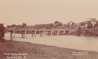
The Windsor Bridge, officially called the Hawkesbury River Bridge, Windsor, a beam bridge across the Hawkesbury River, is located in Windsor in north-western Sydney, New South Wales, Australia. The bridge was built in 1874. On 18 May 2020, the replacement bridge was opened to traffic within Windsor, NSW.
References
- ↑ Andrews, Graeme (1994). Ferries of Sydney (third ed.). Oxford University Press with Sydney University Press. pp. 214–217. ISBN 0-424-00202-7.
- ↑ "Lower Portland Ferry".
- ↑ "Lower Portland Ferry - changes to operating hours".
- ↑ "Sackville Ferry". New South Wales Roads and Traffic Authority. Archived from the original on 25 August 2006. Retrieved 18 November 2008.
- ↑ Roads and Maritime Services, N. S. W. "Vehicle ferries". Roads and Maritime Services. Retrieved 6 December 2019.
Road infrastructure in Sydney | |||||
|---|---|---|---|---|---|
| Motorways |
| ||||
| Other major roads | |||||
| Major interchanges | |||||
| Bridges |
| ||||
| Vehicle ferries | |||||
| Under construction and proposals |
| ||||
| Operators | |||||
| Related articles | |||||
| |
| ||||||||||
|---|---|---|---|---|---|---|---|---|---|---|---|
| |
| ||||||||||
| |
| ||||||||||
| |
| ||||||||||
| |
| ||||||||||
| Other | |||||||||||
Italics denotes services yet to commence | |||||||||||
Hawkesbury River region, New South Wales, Australia | |||||||||
|---|---|---|---|---|---|---|---|---|---|
| Islands | |||||||||
| National parks and nature reserves | |||||||||
| European explorers of the region | |||||||||
| Bridges and ferries |
| ||||||||
| Adjoining rivers, bays, reservoirs, and creeks |
| ||||||||
| Local government areas | |||||||||
| Education | |||||||||
| Major attractions | |||||||||
33°26′18″S150°53′12″E / 33.438335°S 150.886767°E
| | This New South Wales geography article is a stub. You can help Wikipedia by expanding it. |
| | This ferry article is a stub. You can help Wikipedia by expanding it. |