Tom Uglys Bridge

Last updated

Tom Uglys Bridge
Tom ugly bridge.jpg
The Pratt truss spans of the 1929 Tom Uglys Bridge, as viewed from the north
Coordinates 34°00′12″S151°06′48″E / 34.00336111°S 151.1133778°E / -34.00336111; 151.1133778 Coordinates: 34°00′12″S151°06′48″E / 34.00336111°S 151.1133778°E / -34.00336111; 151.1133778
Carries Princes Highway AUS Alphanumeric Route A1.svg
Crosses Georges River
Locale Southern Sydney, New South Wales, Australia
Begins Blakehurst, St George (north)
Ends Sylvania, Sutherland (south)
Owner Transport for NSW
Heritage status
Preceded by Alfords Point Bridge
Followed by Captain Cook Bridge
Characteristics
Design
Material
Total length
  1. 499 m (1,637 ft)
  2. 570 m (1,870 ft)
Longest span
  1. 69.5 m (228 ft)
  2. 70 m (230 ft)
No. of spans
  1. 9
  2. 9
No. of lanes 6
History
Designer
  1. Percy Allan
  2. unknown
Constructed by
  1. State Monier Works
  2. Citra Constructions
Fabrication by
  1. Lindapter International
  2. Citra MED (Homebush)
Construction start
  1. February 1925
  2. unknown
Construction end
  1. 26 April 1929 (1929-04-26)
  2. 17 October 1987 (1987-10-17)
Opened
  1. 11 May 1929 (1929-05-11)
  2. 17 October 1987 (1987-10-17)
ReplacesTom Ugly's Punt
Statistics
Toll
  1. 1929–1952
  2. no toll
Location
Tom Uglys Bridge
References
[1] [2] [3] [4] [5]

Tom Uglys Bridge are two road bridges, completed in 1929 and 1987, that carry the Princes Highway AUS Alphanumeric Route A1.svg across the Georges River in southern Sydney, in the state of New South Wales, Australia. The bridges link the St George area at Blakehurst to the Sutherland Shire at Sylvania. Tom Uglys Bridge is one of six major road crossings of Georges River.

Contents

The 1929 Pratt truss bridge is listed on the New South Wales State Heritage Register and carries three lanes of northbound vehicular traffic on the Princes Highway. The 1987 concrete box girder bridge was built to the east of the older bridge and carries the three southbound lanes of the highway. Both bridges have shared bicycle and pedestrian pathways.

Tom Uglys Point ferries

Twin punts running across the Georges River in 1929. Tomuglyspunt1929.png
Twin punts running across the Georges River in 1929.

Tenders were called to construct a punt for Tom Ugly's Point in 1864. [6] A hand-operated punt service from Tom Ugly's Point to Horse Rock Point commenced. [7] The ferry service was improved and expanded over the years. In 1882 a steam-driven ferry, guided by steel cables, was installed. It crossed the river in less than ten minutes. The punt was 16 metres (54 ft) long, had a 3.4-metre (11 ft) wide roadway, [8] and was capable of carrying six horse-drawn vehicles. By 1898 a larger steam-driven ferry began operation. It was capable of carrying one hundred passengers and fifteen vehicles. [7] A new punt capable of carrying 28 vehicles and making the crossing in three minutes was installed in 1922. [9] By 1929 there were two cable ferries operating, and delays of several hours were experienced on weekends and public holidays.

Description

1929 bridge

Following a long campaign by local councils and motoring authorities, a New South Wales Government loan to Sutherland Shire Council was used to finance the replacement of one of the punt services across the Georges River. [3] The Bill for the building of a bridge across the Georges River was introduced into New South Wales Parliament in 1923, and the foundation stone for the bridge was laid on 7 June 1924. The funds borrowed by Sutherland Shire Council were to be repaid by a bridge toll once it was opened. As use of the punt was free the bridge toll was controversial. [10] The crossing was first opened for traffic on 26 April 1929, [11] and officially opened by the Governor of New South Wales on 11 May 1929. It was known as the "George's River Bridge".

The 1929 bridge consists of nine steel truss spans forming a total length of 499 metres (1,637 ft); [2] [3] six spans were 69.5 metres (228 ft) and three spans were 27.4 metres (90 ft). [4] The bridge was designed by Percy Allan who designed many bridges in New South Wales including the Pyrmont Bridge. When the bridge was opened it was the longest bridge in Australia. [1]

The toll was collected on the Sylvania side of the bridge by toll collectors who stood on the road. On 31 May 1952 the tolls were removed [3] when the Council had repaid the loan to the NSW Government.

In the late 1940s the lanes on the bridge were reconfigured to provide a third lane, and this allow the introduction of a tidal flow system (northbound in the morning and southbound in the evening), which continued until the second bridge was opened. Notwithstanding the creation of the third lane, by the mid 1960s congestion had grown to a significant level, especially on summer weekend afternoons. However it was not for another twenty years that funding was allocated by the New South Wales government for the design and construction of a duplicate bridge.

In 2006, the 1929 steel truss bridge was repainted. The original lead paint was removed using a blasting process and an air extraction system was employed to safely remove airborne particles, protecting the environment as well as the workers. [2]

The 1987 bridge

The second bridge, which opened on 17 October 1987, also comprises nine spans (in order to place the piers in line with those of the first bridge) of three identical steel box girders, composite with a cast-in-place reinforced concrete deck; the major spans are 70 metres (230 ft) in length with end spans of 50 metres (160 ft). [5]

The new bridge was designed to carry four lanes of traffic. During repair work on the 1929 bridge, when it was temporarily closed to traffic, the 1987 bridge was configured both for one lane northbound and three lanes southbound.

Features of both bridges

Most duplicate bridges are close together (like the dual bridges at Ryde) and parallel, allowing the form of the road approaches to continue. However, at Tom Uglys Point, the two bridges are not parallel. They are less than 5 metres (16 ft) apart at the northern end, but about 62 metres (203 ft) apart at the southern end. This avoids replication of the pair of tight curves on the southern approach to the 1929 bridge on the southern exit from the second bridge.

On the southern side, between the two bridges, is a boat ramp, accessible from the northbound bridge approach. On the northern side a loop road allows drivers travelling south along the Princes Highway (A1) to avoid the bridge and return northwards along the highway.

Etymology

Tom Uglys Bridge took its name from the geographical feature at the northern end of the bridge, known as Tom Uglys Point. The point was known as Tom Uglys Point over 80 years prior to the construction of the bridge. At various times the bridge is incorrectly transcribed as Tom Ugly's Bridge.

There are several theories about the origin of the name of the point.

The name was officially adopted to distinguish between the various subsequent bridges across Georges River, after the opening of the Captain Cook Bridge in 1965 and the Alfords Point Bridge in 1973. [15]

See also

Related Research Articles

Gladesville Bridge Bridge in Sydney, Australia

Gladesville Bridge is a heritage-listed concrete arch road bridge that carries Victoria Road over the Parramatta River, linking the Sydney suburbs of Huntleys Point and Drummoyne, in the local government areas of Canada Bay and Hunter's Hill, in New South Wales, Australia. Despite its name, the bridge is not located in Gladesville.

Ryde Bridge Bridges across the Parramatta River in Sydney, Australia

The Ryde Bridge(s), also called the Uhrs Point Bridge, are two road bridges that carry Concord Road, part of the A3, across Parramatta River from Ryde in the northern suburbs of Sydney to Rhodes in Sydney's inner west, in New South Wales, Australia.

Blakehurst, New South Wales Suburb of Sydney, New South Wales, Australia

Blakehurst is a suburb in southern Sydney, in the state of New South Wales, Australia 18 kilometres south of the Sydney central business district, in the local government area of the Georges River Council. It is part of the St George area.

Eastern Distributor Motorway in Sydney, Australia

The Eastern Distributor is a 4.7-kilometre-long (2.9 mi) motorway in Sydney, New South Wales, Australia. Part of the M1, the motorway links the Sydney central business district with Sydney Airport. The centre-piece is a 1.7 km (1.1 mi) tunnel running from Woolloomooloo to Surry Hills. Built as a build-own-operate-transfer project, it is 75.1% owned by Transurban.

Warringah Freeway

The Warringah Freeway is a 3-kilometre (1.9 mi) divided freeway located in Sydney, New South Wales, Australia. The freeway forms part of the M1, the Sydney Orbital Network, and the Highway 1 network. The primary function of the freeway is to provide an alternative high-grade route from the Sydney Harbour Tunnel and the Bradfield Highway at Milsons Point to the A8 and the Gore Hill Freeway. The freeway reduces traffic demands on the Pacific Highway throughout Sydney's Lower North Shore, bypassing North Sydney and Crows Nest. Completed in a series of stages between June 1968 and August 1992, the Warringah Freeway provides a vital link to access most of the suburbs in Sydney and is also a major route to the north, south, east and west of the central business district.

Iron Cove Bridge

The Iron Cove Bridge is a heritage-listed road bridge that carries Victoria Road (A40) across Iron Cove, linking the Sydney suburbs of Drummoyne to Rozelle in the City of Canada Bay local government area of New South Wales, Australia.

Princes Bridge Bridge across the Yarra River in Melbourne, Australia

Princes Bridge, originally Prince's Bridge, is a bridge in central Melbourne, Australia that spans the Yarra River. It is built on the site of one of the oldest river crossings in the city, and forms a gateway into the central city from the south. The bridge connects Swanston Street on the north bank of the Yarra River to St Kilda Road on the south bank, and carries road, tram and pedestrian traffic. The present bridge was built in 1888 and is listed on the Victorian Heritage Register.

Captain Cook Bridge, Sydney

The Captain Cook Bridge is a road bridge that carries Taren Point and Rocky Point Roads across the Georges River in southern Sydney, in the state of New South Wales, Australia. The precast prestressed concrete girder bridge crosses near the river mouth as it empties into Botany Bay; and links the St George and Sutherland areas of Sydney. The bridge comprises a dual carriageway with three lanes in each direction of highway grade-separated conditions; and pedestrian and bicycle traffic, via two grade-separated paths. on the eastern and western sides of the bridge.

Alfords Point Bridge

Alfords Point Bridge is a twin 445-metre-long (1,460 ft) concrete and steel box girder road bridge that carries Alford Point Road as state route A6 across the lower Georges River between Padstow Heights in the City of Bankstown and Alfords Point in the Sutherland Shire in Sydney, New South Wales, Australia.

Nowra Bridge

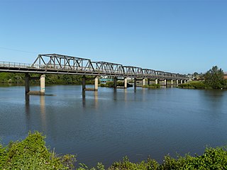
The Nowra Bridge is a road bridge that carries the Princes Highway over the Shoalhaven River, at Nowra in the Shoalhaven Council local government area, on the South Coast of New South Wales, Australia. The bridge joins the main area of Nowra to North Nowra and Bomaderry.

Victoria Bridge (Penrith) Heritage-listed bridge across the Nepean River in Sydney, Australia

The Victoria Bridge (Penrith), also known as the Victoria Bridge over Nepean River and officially known as The Nepean Bridge, is a heritage-listed former railway bridge and now wrought iron box plate girder road bridge across the Nepean River on the Great Western Highway in the western Sydney suburb of Penrith in the City of Penrith local government area of New South Wales, Australia. The bridge was designed by John Whitton, the Engineer–in–Chief of New South Wales Government Railways, and built from 1862 to 1867 by William Piper, Peto Brassey and Betts (superstructure), William Watkins (piers). It is also known as Victoria Bridge, The Nepean Bridge and RTA Bridge No. 333. It was added to the New South Wales State Heritage Register on 27 May 2016.

Mooney Mooney Bridge

The Mooney Mooney Bridge, officially the Mooney Mooney Creek Bridge, and popularly known as The NSW Big Dipper Bridge, is a twin cantilever bridge that carries the Pacific Motorway (M1) across Mooney Mooney Creek, located near Mooney Mooney in the Brisbane Water National Park on the Central Coast of New South Wales, Australia. The concrete box girder bridge was opened on 14 December 1986 by the Prime Minister of Australia, Bob Hawke, and is owned and maintained by Transport for NSW, an agency of the Government of New South Wales.

De Burghs Bridge is a road bridge that carries the Lane Cove Road, part of the A3, across the Lane Cove River in Macquarie Park, Sydney, Australia. The bridge stretches from Macquarie Park in the south to West Pymble in the north.

Peats Ferry Bridge

The Peats Ferry Bridge is a steel truss bridge that carries the Pacific Highway (B83) across the Hawkesbury River, between Kangaroo Point and Mooney Mooney Point, located 40 kilometres (25 mi) north of Sydney in New South Wales, Australia. The bridge carries the Hornsby to Kariong section of highway, while the adjacent Brooklyn Bridge carries the Pacific Motorway (M1).

Percy Allan

Percy Allan was a civil engineer who designed many public works in New South Wales, including the design of 583 bridges.

Martin Bridge

The Martin Bridge is a road bridge that carries the Manning River Drive across the Manning River in Taree, in the Mid North Coast region of New South Wales, Australia. In 2010 the bridge was added to New South Wales State Heritage Register.

Prince Alfred Bridge 1860s wrought iron truss bridge in Gundagai

The Prince Alfred Bridge is a wrought iron truss and timber beam partially-disused road bridge over the Murrumbidgee River and its floodplain at Middleton Drive, Gundagai, Cootamundra-Gundagai Regional Council, New South Wales, Australia. The heritage-listed road bridge was designed by William Christopher Bennett and built from 1864 to 1867 by Francis Bell. It is also known as Prince Alfred Bridge - Iron Road Bridge and Iron Bridge over Murrumbidgee River at Gundagai. The iron bridge is owned by Transport for NSW and the timber viaduct is owned by Crown Lands. The bridge was added to the New South Wales State Heritage Register on 5 July 2019 and on the Register of the National Estate on 21 March 1978.

Brooklyn Bridge, New South Wales

The Brooklyn Bridge is a concrete girder bridge that carries the Pacific Motorway (M1) across the Hawkesbury River between Kangaroo Point to Mooney Mooney Point, located 35 kilometres (22 mi) north of Sydney in New South Wales, Australia. The bridge comprises a dual carriageway with three lanes in each direction of motorway grade-separated conditions.

Milperra Bridge is a road bridge that carries Newbridge Road across the Georges River, located between Bankstown and Liverpool, in South Western Sydney, New South Wales, Australia. The bridge is located adjacent to Henry Lawson Drive and the Bankstown Airport; and Newbridge Road serves as a continuation of Canterbury and Milperra Roads.

Hay Bridge, New South Wales

The Hay Bridge is a road bridge that carries the Cobb Highway across the Murrumbidgee River at Hay, New South Wales, Australia. The current bridge is the second bridge located in Hay that crosses the Murrumbidgee; the first bridge was in operation from 1873 until 1973; the second and current bridge has operated since 1973.

References

  1. 1 2 "Tom Uglys Bridge over the Georges River (1929)". Heritage and conservation register. Roads & Traffic Authority. 16 March 2001. Retrieved 14 June 2014.
  2. 1 2 3 4 "Tom Ugly's Bridge: Maintenance works" (PDF). Roads & Traffic Authority (PDF).
  3. 1 2 3 4 "Princes Highway - History and Development". Ozroads. Retrieved 14 June 2014.
  4. 1 2 "Tom Ugly's Bridge". Structurae. Retrieved 14 June 2014.
  5. 1 2 Bott, G. J.; Wheeler, W. K. (1984). "Design of the new Tom Uglys Bridge, Sydney". Australian Road Research. Vermont South, Victoria: ARRB Group Limited. 12 (2): 28–41. ISSN   0005-0164.
  6. "Tenders for Public Works and Supplies". Sydney Morning Herald . National Library of Australia. 9 April 1864. Retrieved 13 September 2010.
  7. 1 2 3 4 "Kogarah's Heritage No. 2: Tom Ugly's". Kogarah Council . Retrieved 23 April 2015.
  8. "Steam Punt for George's River". The Sydney Morning Herald . National Library of Australia. 12 May 1882. Retrieved 13 September 2010.
  9. "The Punts: New and Enlarged". The Sydney Morning Herald . 19 April 1922.
  10. "LOCAL GOVERNMENT. - THE SHIRES CONFERENCE. - The Sydney Morning Herald (NSW : 1842 - 1954) - 16 May 1929". Trove. Retrieved 7 November 2016.
  11. "Bridge over George's River at Tom Ugly's Point opened for traffic". The Sydney Morning Herald . 27 April 1929.
  12. "Georges River: Tom Uglys Point". The Sydney Morning Herald . 31 January 1931.
  13. Goodall, Heather; Cadzow, Alison (2009). Rivers and Resilience: Aboriginal People on Sydney's Georges River. UNSW Press. p. 66.
  14. "Native Nomenclature". The Sydney Morning Herald . 7 May 1890. Retrieved 13 September 2010.
  15. Pollon, Frances, ed. (1990). The Book of Sydney Suburbs. Australia: Angus & Robertson Publishers. p. 118. ISBN   0-207-14495-8.

Further reading