Captain Cook Bridge, Sydney

Last updated

Captain Cook Bridge, Sydney
Captain Cook Bridge3.JPG
Captain Cook Bridge, viewed from Sans Souci
Coordinates 34°00′29″S151°07′39″E / 34.00794444°S 151.1276083°E / -34.00794444; 151.1276083
Carries Taren Point / Rocky Point Roads
Crosses Georges River
Locale Southern Sydney, New South Wales, Australia
Named for Captain James Cook
Owner Transport for NSW
Preceded by Tom Uglys Bridge
Characteristics
Design Box girder
Material Precast prestressed concrete
Total length506 metres (1,660 ft)
Width27.5 metres (90 ft)
No. of spans7
No. of lanes
History
Constructed by John Holland Group
Construction start1962 (1962)
Construction end1965 (1966)
Construction costA$3 million
Opened29 May 1965 (1965-05-29)
Replaces Punt
  • between Sans Souci and Taren Point: (1916–1929)
Location
Captain Cook Bridge, Sydney
References
[1]

The Captain Cook Bridge is a road bridge that carries Taren Point and Rocky Point Roads across the Georges River in southern Sydney, in the state of New South Wales, Australia. The precast prestressed concrete girder bridge crosses near the river mouth as it empties into Botany Bay; and links the St George and Sutherland areas of Sydney. The bridge comprises a dual carriageway with three lanes in each direction of highway grade-separated conditions; and pedestrian and bicycle traffic, via two grade-separated paths. on the eastern and western sides of the bridge.

Contents

Location and features

The Captain Cook Bridge consists of seven spans totalling 475 metres (1,558 ft) in length, with a 506-metre (1,660 ft) long deck that is 27.5 metres (90 ft) wide with six traffic lanes and two shared bicycle and pedestrian paths. Its foundations extend as deep as 67 metres (220 ft) below water level to its sandstone base. The bridge was opened on 29 May 1965 [1] and links Rocky Point Road at Sans Souci in the St George area to Taren Point Road at Taren Point in the Sutherland Shire. Loop walkways run under the bridge at both sides and provide access along the foreshore.

The bridge was designed by a team of engineers from the Department of Main Roads (DMR) led by Albert Fried. The DMR's Resident Engineer for the construction was Ray Wedgwood, who was later the Chief Bridge Engineer for the Roads and Traffic Authority. The main contractor was John Holland Group. [2]

The bridge is the easternmost of the seven major crossings of Georges River. The others are Tom Uglys Bridge, which opened in 1929, Alfords Point Bridge (1973, duplicated 2008), M5 Milperra bridge (1992), Milperra Bridge (replacement bridge 1966), Liverpool Bridge (replacement bridge 1958), and M5 Casula bridge (1985, widened 1988).

The Captain Cook Bridge is the only section of the planned F6 Freeway that has been built in the Sydney metropolitan area, with the other built sections being between Waterfall and Bulli Tops and further south between Gwynneville and Yallah. [1] On the southern approach the two carriageways of the approach road diverge to allow for construction of a future interchange to also carry freeway traffic to and from the bridge.

The speed limit on the bridge and the 1 km (0.62 miles) of freeway on the southern approach is 80 kilometres per hour (50 mph).

The bridge was designed to have the capacity to carry 30,000 vehicles on a weekday, but in 2015 the bridge was estimated to be carrying 30,600 vehicles per weekday. [3]

History

A ferry service ran between Sans Souci and Taren Point from 1911. From April 1916 a vehicular punt ran between the two points, [4] and continued to do so even after the opening of the Tom Uglys Bridge in 1929.

The Captain Cook Bridge is named in honour of Captain James Cook, a British explorer, navigator, cartographer, and captain in the Royal Navy, who landed at nearby Kurnell on 29 April 1770, during his first voyage of discovery aboard the Endeavour . [5]

A big part of commissioning construction of the Captain Cook Bridge in 1962 was that the nearby three-laned Tom Ugly's Bridge was carrying more traffic than any three lanes of the Sydney Harbour Bridge, and the Taren Point punt was at full capacity carrying 1000 cars daily. [3]

See also

Related Research Articles

<span class="mw-page-title-main">Captain Cook Bridge, Brisbane</span> Bridge in Queensland, Australia

The Captain Cook Bridge is a road bridge that carries the Pacific Motorway across the Brisbane River in Brisbane, in the state of Queensland, Australia. It was built exclusively for vehicular traffic and was completed in late 1972. The bridge had its naming ceremony on 13 December 1972, with it opening in January/February 1973. A once only pedestrian walk event across the bridge happened shortly before it was opened to vehicular traffic on 21 January 1973, organised by the Rotary Club of Stones Corner. The bridge crosses at the South Brisbane Reach of the river, linking Gardens Point in the Brisbane central business district on the north side to Kangaroo Point and South Brisbane on the southside.

<span class="mw-page-title-main">Georges River</span> River in New South Wales, Australia

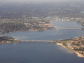
The Georges River, also known as Tucoerah River, is an intermediate tide-dominated drowned valley estuary, located to the south and west of Sydney, New South Wales, Australia.

<span class="mw-page-title-main">Gladesville Bridge</span> Bridge in Sydney, Australia

Gladesville Bridge is a heritage-listed concrete arch road bridge that carries Victoria Road over the Parramatta River, linking the Sydney suburbs of Huntleys Point and Drummoyne, in the local government areas of Canada Bay and Hunter's Hill, in New South Wales, Australia. Despite its name, the bridge is not in Gladesville.
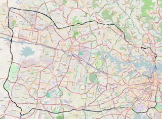
<span class="mw-page-title-main">Princes Highway</span> Highway in Australia

Princes Highway is a major road in Australia, extending from Sydney via Melbourne to Adelaide through the states of New South Wales, Victoria and South Australia. It has a length of 1,941 kilometres (1,206 mi) or 1,898 kilometres (1,179 mi) via the former alignments of the highway, although these routes are slower and connections to the bypassed sections of the original route are poor in many cases.

<span class="mw-page-title-main">Abernethy Bridge</span> Bridge in Oregon City, Oregon

The George Abernethy Bridge, or simply Abernethy Bridge, is a steel plate and box girder bridge that spans the Willamette River between Oregon City and West Linn, Oregon, United States, and which carries Interstate 205. It is also known as the Oregon City Freeway Bridge and the I-205 Bridge.

<span class="mw-page-title-main">Princes Motorway</span> Motorway in New South Wales, Australia

The Princes Motorway is a 62-kilometre (39 mi) predominantly dual carriage untolled motorway that links Sydney to Wollongong and further south through the Illawarra region to Albion Park Rail. Part of the Australian Highway 1 network, the motorway is designated with the route number M1.

<span class="mw-page-title-main">Sans Souci, New South Wales</span> Suburb of Sydney, New South Wales, Australia

Sans Souci is a Southern Sydney suburb in the state of New South Wales, Australia. Sans Souci is 17 kilometres south of the Sydney central business district and lies across the local government areas of the Bayside Council and the Georges River Council. It is part of the St George area.

<span class="mw-page-title-main">Taren Point, New South Wales</span> Suburb of Sydney, New South Wales, Australia

Taren Point is a small suburb, in southern Sydney, in the state of New South Wales, Australia 20 kilometres south of the Sydney central business district in the local government area of the Sutherland Shire.

<span class="mw-page-title-main">Warringah Freeway</span> Freeway in Sydney, Australia

Warringah Freeway is a 3.5-kilometre (2.2 mi) divided freeway in Sydney, New South Wales that is part of the Sydney Orbital Network. The primary function of the freeway is to provide an alternative high-grade route from the Sydney Harbour Tunnel and Bradfield Highway at Milsons Point to the A8 and Gore Hill Freeway. The freeway reduces traffic demands on Pacific Highway throughout Sydney's Lower North Shore, bypassing North Sydney and Crows Nest, and provides a vital link to access most of the suburbs in Sydney and is also a major route to the north, south, east and west of the central business district.

<span class="mw-page-title-main">Tom Uglys Bridge</span> Australian road bridge

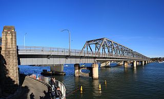
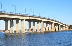
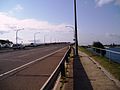
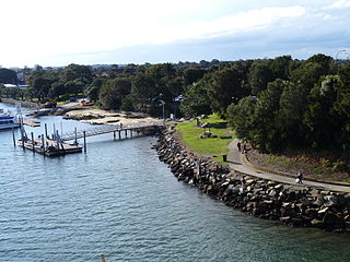
Tom Uglys Bridge are two road bridges, completed in 1929 and 1987, that carry the Princes Highway across the Georges River in southern Sydney, in the state of New South Wales, Australia. The bridges link the St George area at Blakehurst to the Sutherland Shire at Sylvania. Tom Uglys Bridge is one of six major road crossings of Georges River.

<span class="mw-page-title-main">Alfords Point Bridge</span> Bridge in New South Wales, Australia

Alfords Point Bridge is a twin 445-metre-long (1,460 ft) concrete and steel box girder road bridge that carries Alford Point Road as state route A6 across the lower Georges River between Padstow Heights in the City of Canterbury-Bankstown and Alfords Point in the Sutherland Shire in Sydney, New South Wales, Australia.

<span class="mw-page-title-main">Taren Point Road</span> Road in New South Wales

Taren Point Road is a major road found in Taren Point and Caringbah, New South Wales, Australia.

<span class="mw-page-title-main">Mooney Mooney Bridge</span> Bridge in New South Wales, Australia

The Mooney Mooney Bridge, officially the Mooney Mooney Creek Bridge, and popularly known as The NSW Big Dipper Bridge, is a twin cantilever bridge that carries the Pacific Motorway (M1) across Mooney Mooney Creek, located near Mooney Mooney in the Brisbane Water National Park on the Central Coast of New South Wales, Australia. The concrete box girder bridge was opened on 14 December 1986 by the Prime Minister of Australia, Bob Hawke, and is owned and maintained by Transport for NSW, an agency of the Government of New South Wales.

<span class="mw-page-title-main">General Holmes Drive</span> Road in Sydney, Australia

General Holmes Drive is a 5-kilometre (3.1 mi) major divided road located in Sydney, New South Wales, Australia. The road forms part of the M1, the A1, the Sydney Orbital Network, and the Australian Highway 1 network. Initially built in 1919 as a two-lane road and duplicated in 1951, the road partially circumnavigates Sydney Airport with its north-eastern terminus in Mascot, heading west and then south and then south-west, with its south-western terminus with The Grand Parade in Brighton-Le-Sands.

<span class="mw-page-title-main">Henry Lawson Drive</span> Road in Sydney, Australia

Henry Lawson Drive is an 20-kilometre (12 mi) urban road linking Lansdowne and Peakhurst in the south-western suburbs of Sydney, New South Wales, Australia. The road is named in honour of Henry Lawson (1867–1922), one of Australia's foremost poets.

<span class="mw-page-title-main">Peats Ferry Bridge</span> Bridge in New South Wales, Australia

The Peats Ferry Bridge is a steel truss bridge that carries the Pacific Highway (B83) across the Hawkesbury River, between Kangaroo Point and Mooney Mooney Point, located 40 kilometres (25 mi) north of Sydney in New South Wales, Australia. The bridge carries the Hornsby to Kariong section of highway, while the adjacent Brooklyn Bridge carries the Pacific Motorway (M1).

<span class="mw-page-title-main">Brooklyn Bridge, New South Wales</span> Bridge in New South Wales, Australia

The Brooklyn Bridge is a local nickname for the Hawkesbury River Road Bridge, a concrete girder bridge that carries the Pacific Motorway (M1) across the Hawkesbury River between Kangaroo Point to Mooney Mooney Point, located 35 kilometres (22 mi) north of Sydney in New South Wales, Australia. The bridge comprises a dual carriageway with three lanes in each direction of motorway grade-separated conditions.

Milperra Bridge is a road bridge that carries Newbridge Road across the Georges River, located between Bankstown and Liverpool, in South Western Sydney, New South Wales, Australia. The bridge is located adjacent to Henry Lawson Drive and the Bankstown Airport; and Newbridge Road serves as a continuation of Canterbury and Milperra Roads.

The M6 Motorway is an under-construction motorway in Sydney, New South Wales consisting of twin, 4-kilometre long tunnels linking the M8 Motorway at Arncliffe to President Avenue at Kogarah. Stage 1 started major construction in November 2021 and is expected to open in late 2025. The possibility of future extensions to the south will be accommodated by providing stub tunnels in the project.

<span class="mw-page-title-main">Ray Wedgwood</span> Australian civil and bridge engineer (1942-2020)

Raymond John Lloyd Wedgwood was an Australian engineer who served as the Chief Bridge Engineer of the Department of Main Roads and the Roads & Traffic Authority in New South Wales. He designed and supervised the construction of many major bridges across New South Wales and led the design team for the cable stayed Anzac Bridge in Sydney. He also played a pivotal role in the development of a common code of bridge design practice used by all Australian state road authorities.

References

  1. 1 2 3 "1965 – Captain Cook Bridge". Sydney for everyone. Archived from the original on 21 December 2013. Retrieved 14 June 2014.
  2. "The Opening of the Captain Cook Bridge (1965)". Sydney Flashbacks. Retrieved 4 January 2020.
  3. 1 2 Trembath, Murray (5 June 2015). "Captain Cook Bridge anniversary a reminder of unfinished work". St George & Sutherland Shire Leader . Retrieved 13 June 2015.
  4. "George's River Ferry". The Sydney Morning Herald . 4 March 1916. Retrieved 13 September 2010.
  5. "Captain Cook Bridge (1965), southern approach". Heritage and conservation register. Roads & Traffic Authority. 18 November 2005. Retrieved 13 September 2010.