A34 (Sydney)

Last updated

A34

(numerous constituent roads)

AUS Alphanumeric Route A34.svg
Newtown NSW, Cnr King Street & Enmore Road, 2019.jpg
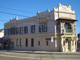
Eastern end of A34 (Enmore Road) at Newtown
Location map Australia Sydney.png
Red pog.svg
West end
Red pog.svg
East end
Coordinates
General information
TypeRoad
Length26.2 km (16 mi) [1]
Gazetted August 1928 [2]
Route number(s) AUS Alphanumeric Route A34.svg A34 (2013–present)
Former
route number
Australian state route 54.svg State Route 54 (1974–2013)
Major junctions
West endAUS Alphanumeric Route A28.svg Hume Highway
Liverpool, Sydney
 
East endAUS Alphanumeric Route A36.svg King Street
Newtown, Sydney
Location(s)
Major suburbs Milperra, Bankstown, Punchbowl, Lakemba, Canterbury, Dulwich Hill, Petersham, Enmore
Highway system

The A34 is a route designation of a major metropolitan arterial route through suburban Sydney, linking Hume Highway at Liverpool and Princes Highway at Newtown, running parallel to the tolled M5 Motorway. This name covers a few consecutive roads and is widely known to most drivers, but the entire allocation is also known – and signposted – by the names of its constituent parts: Macquarie Street, Terminus Street, Newbridge Road, Milperra Road, (New) Canterbury Road, Stanmore Road and Enmore Road. [3]

Contents

Route

The A34 commences at the intersection with Hume Highway and Hoxton Park Road in Liverpool and heads in an easterly direction as Macquarie Street as a four-lane, single-carriageway road, turning into Terminus Street very shortly afterwards. It changes name to Newbridge Road and crosses the Georges River for the first time, intersecting with Heathcote Road shortly afterwards, and widening to a six-lane, dual-carriageway road. It continues east through Moorebank, crosses the Georges River again and meets Henry Lawson Drive at Milperra. It changes name to Milperra Road and continues in an easterly direction until it reaches The River Road in Revesby, where it changes name again to Canterbury Road, meeting King Georges Road at Roselands. At Hurlstone Park, the route splits off east to become New Canterbury Road. It changes name to Stanmore Road at the intersection of Crystal and Shaw Streets at Petersham, and intersecs with and changes name to Enmore Road at the intersection with Edgeware Road in Enmore, before eventually terminating at the intersection with King Street in Newtown. [1] [4]

History

The passing of the Main Roads Act of 1924 [5] through the Parliament of New South Wales provided for the declaration of Main Roads, roads partially funded by the State government through the Main Roads Board (later the Department of Main Roads, and eventually Transport for NSW). Main Road No. 167 was declared on 8 August 1928, from the intersection with King Street in Newtown, along Enmore and Stanmore Roads, New Canterbury Road and Canterbury Road to the intersection with Chapel Road in Bankstown; [2] with the passing of the Main Roads (Amendment) Act of 1929 [6] to provide for additional declarations of State Highways and Trunk Roads, this was amended to Main Road 167 on 8 April 1929.

Main Road 512 was declared between Heathcote Road and Hume Highway in Liverpool on 15 November 1939 (and continuing southeast along Heathcote Road via Lucas Heights to Princes Highway at Heathcote); [7] the western end of Main Road 167 was later extended along Milperra and Newbridge Roads to meet Main Road 512 (Heathcote Road) at Moorebank on 20 March 1940. [8]

The passing of the Roads Act of 1993 [9] updated road classifications and the way they could be declared within New South Wales. Under this act, the A34 retains its declaration as Main Road 167 (from Moorebank to Newtown), and part of Main Road 512 (Liverpool to Moorebank). [10]

The route was allocated State Route 54 in 1974, from Liverpool to Newtown. In 1993, its eastern end was extended along King Street and City Road to the intersection with Broadway at Chippendale (replacing State Route 66, itself having replaced National Route 1 the previous year when the opening of the Sydney Harbour Tunnel had it re-aligned). [11] With the conversion to the newer alphanumeric system in 2013, State Route 54 was truncated back to its original eastern terminus at King Street in Newtown and replaced by route A34, with the former extension replaced by route A36 as part of Princes Highway. [4]

Major intersections

LGALocationkm [1] miDestinationsNotes
Liverpool Liverpool 0.00.0AUS Alphanumeric Route A28.svg Hume Highway (A28)  Cabramatta, Camden, Campbelltown Western terminus of route A34
Western end of Macquarie Street
Hoxton Park Road  Hoxton Park, Austral
0.30.19Macquarie Street (east)  Liverpool Eastbound entrance and westbound exit only
Eastern end of Macquarie Street, western end of Terminus Street
0.80.50Terminus Street (east)  Liverpool
Speed Street (south)  Liverpool
Eastbound exit to Terminus Street only, no right turn eastbound into Speed Street
Eastern end of Terminus Street, western end of Newbridge Road
0.90.56 Main Southern railway line
Georges River 1.10.68Light Horse Bridge
Liverpool Moorebank 1.40.87 Heathcote Road   Wattle Grove, Lucas Heights, Heathcote
Georges River 5.93.7 Milperra Bridge
Canterbury-Bankstown MilperraBankstown Aerodrome boundary6.03.7 Henry Lawson Drive   Lansdowne, Padstow Heights Eastern end of Newbridge Road
Western end of Milperra Road
Revesby 9.86.1The River Road  Revesby Heights Eastern end of Milperra Road
Western end of Canterbury Road
Bankstown 11.67.2AUS Alphanumeric Route A6.svg Fairford Road (A6)  Carlingford, Lidcombe, Padstow, Heathcote No right turn westbound into Fairford Road, no southbound exit from Fairford Road
Punchbowl 12.47.7Punchbowl Road (north)  Punchbowl, Croydon Park
Bramhall Avenue (south)  Punchbowl
Wiley ParkRoselands boundary15.09.3AUS Alphanumeric Route A3.svg King Georges Road (A3)  Mona Vale, Ryde, Greenacre, Blakehurst
Cooks River 19.512.1Bridge (no known official name)
Canterbury-Bankstown Canterbury 19.712.2 Bankstown railway line
Canterbury-BankstownInner West boundary Hurlstone ParkAshfieldDulwich Hill tripoint20.913.0Old Canterbury Road (north)  Lewisham
Griffiths Street (west)  Ashfield
Eastern end of Canterbury Road
Western end of New Canterbury Road
Inner West Dulwich Hill 21.913.6 Inner West Light Rail
Petersham 24.115.0Crystal Street (north)  Leichhardt
Shaw Street (south)  Petersham
Eastern end of New Canterbury Road
Western end of Stanmore Road
Enmore 25.515.8Enmore Road (southwest)  Marrickville
Edgeware Road (southeast)  St Peters
Eastern end of New Canterbury Road
Western end of Enmore Road
Inner WestSydney boundary Newtown 26.216.3 Main Suburban railway line
AUS Alphanumeric Route A36.svg King Street (A36)  Chippendale, Blakehurst, Heathcote Eastern terminus of route A34
Eastern end of Enmore Road

See also

Australia road sign W5-29.svg   Australian Roadsportal

Related Research Articles

<span class="mw-page-title-main">New England Highway</span> Highway in New South Wales and Queensland

New England Highway is an 883-kilometre (549 mi) long highway in Australia running from Yarraman, north of Toowoomba, Queensland, at its northern end to Hexham at Newcastle, New South Wales, at its southern end. It is part of Australia's National Highway system, and forms part of the inland route between Brisbane and Sydney.

<span class="mw-page-title-main">Monaro Highway</span> Highway in Australia

Monaro Highway is a 285-kilometre-long (177 mi) highway in Victoria, New South Wales, and the Australian Capital Territory, in Australia, linking Cann River in Victoria to Canberra in the Australian Capital Territory (ACT) via the Monaro region. From its southern terminus, it follows the nearby Cann River upstream towards the New South Wales border through heavily forested terrain. Within New South Wales (NSW), it makes its way through further forest before reaching the pastures typical of the Monaro. There are multiple towns and villages along the highway, including Bombala, Nimmitabel, and Cooma. The terrain within the Monaro is largely hilly, and there are numerous crossings. The road also parallels the former Bombala railway line in several locations. Within the ACT, the road becomes a high volume roadway and serves the southern suburbs of Canberra. The highway has more recently had a grade-separated dual carriageway extension constructed within Canberra, as part of the Eastern Parkway construction project. It is designated part of route M23, and route A23 within Canberra, and route B23 within Victoria and New South Wales, with a concurrency where it also carries route B72 between the two sections of Snowy Mountains Highway.

<span class="mw-page-title-main">A6 (Sydney)</span>

The A6 is a route designation of a major metropolitan arterial route through suburban Sydney, linking Cumberland Highway at Carlingford and Princes Highway at Heathcote, via Lidcombe and Bankstown. This name covers a few consecutive roads and is widely known to most drivers, but the entire allocation is also known – and signposted – by the names of its constituent parts: Marsden Road, Stewart Street, Kissing Point Road, Silverwater Road, St Hilliers Road, Boorea Street, Olympic Drive, Joseph Street, Rookwood Road, Stacey Street, Fairford Road, Davies Road, Alfords Point Road, New Illawarra Road and Heathcote Road.

<span class="mw-page-title-main">A3 (Sydney)</span>

The A3 is a route designation of a major metropolitan arterial route through suburban Sydney, connecting the A8 at Mona Vale at its northern end, to Princes Highway at Blakehurst at its southern end. This name covers a few consecutive roads and is widely known to most drivers, but the entire allocation is also known – and signposted – by the names of its constituent parts: Mona Vale Road, Ryde Road, Lane Cove Road, Devlin Street, Church Street, Concord Road, Homebush Bay Drive, Centenary Drive, Roberts Road, Wiley Avenue and King Georges Road.

<span class="mw-page-title-main">Cumberland Highway</span> Highway in Sydney, New South Wales, Australia

Cumberland Highway is a 34-kilometre (21 mi) long urban highway located in Sydney, New South Wales, Australia. The highway links Pacific Highway and Pacific Motorway (M1) at Pearces Corner, Wahroonga in the northeast with Hume Highway at Liverpool in the southwest. This name covers a few consecutive roads and is widely known to most drivers, but the entire allocation is also known – and signposted – by the names of its constituent parts: Pennant Hills Road, James Ruse Drive, Briens Road, Old Windsor Road, Hart Drive, Freame Street, Emert Street, Jersey Road, Betts Road, Warren Road, Smithfield Road, Palmerston Road, (New) Cambridge Street, Joseph Street and Orange Grove Road. The entire length of Cumberland Highway is designated part of route A28.

<span class="mw-page-title-main">Dulwich Hill</span> Suburb of Sydney, New South Wales, Australia

Dulwich Hill is a suburb in the Inner West of Sydney, in the state of New South Wales, Australia. It is 7.5 kilometres south-west of the Sydney central business district, in the local government area of Inner West Council. Dulwich Hill stretches south to the shore of the Cooks River.

<span class="mw-page-title-main">Milperra</span> Suburb of Sydney, New South Wales, Australia

Milperra, a suburb of local government area City of Canterbury-Bankstown, is located 24 kilometres west of the Sydney central business district in the state of New South Wales, Australia, and is a part of the South Western Sydney region.
<span class="mw-page-title-main">Enmore, New South Wales</span> Suburb of Sydney, New South Wales, Australia

Enmore is a suburb in the Inner West of Sydney, in the state of New South Wales, Australia. Enmore is located 5 kilometres (3.1 mi) south-west of the Sydney central business district and is part of the local government area of Inner West Council. Like Newtown, Enmore is mostly comprises Victorian era buildings, namely in its commercial area, that provide a hint of the suburb's rich cultural heritage.

<span class="mw-page-title-main">Irrigation Way</span>

Irrigation Way is a major rural road that runs approximately 85 kilometres (53 mi) through the Murrumbidgee Irrigation Area in south western New South Wales, Australia.

<span class="mw-page-title-main">Appin Road</span> Road in New South Wales, Australia

Appin Road is a New South Wales secondary highway linking Campbelltown and Sydney's western suburbs with Wollongong. It is named after Appin, which lies on its path.

<span class="mw-page-title-main">Pennant Hills Road</span> Highway in Sydney, Australia

Pennant Hills Road is a 16.1-kilometre-long (10.0 mi) arterial road located in Sydney, New South Wales, Australia. The road links the suburb of Wahroonga in the northeast, to the major central business district of Parramatta in the southwest. Apart from a small section at its southwestern end, it is a constituent part of Cumberland Highway, and is designated part of route A28.

<span class="mw-page-title-main">M5 Motorway (Sydney)</span> Motorway in Sydney, Australia

The M5 Motorway is a 28.8-kilometre (17.9 mi) series of tolled motorways located in Sydney, New South Wales designated as route M5. It is part of the Sydney Orbital Network.

<span class="mw-page-title-main">King Georges Road, Sydney</span> Road in Sydney, Australia

King Georges Road is a 9.0-kilometre-long (5.6 mi) major suburban arterial road through south-western Sydney, Australia. It is a constituent part of the A3 route.

Central Coast Highway is a 50-kilometre (31 mi) highway through the Central Coast region of New South Wales, Australia. It connects Pacific Motorway (M1) at Kariong with Pacific Highway (A43) at Doyalson. The highway was named after the region it goes through, to provide an easily identifiable route for visitors to the region, and is designated route A49.

<span class="mw-page-title-main">Goulburn-Oberon Road</span>

Goulburn-Oberon Road is a New South Wales country road linking Goulburn near Hume Highway to Oberon. This name is not widely known to most drivers, as the entire allocation is still best known as by the names of its constituent parts: Taralga Road and Abercrombie Road.

<span class="mw-page-title-main">Henry Lawson Drive</span> Road in Sydney, Australia

Henry Lawson Drive is an 20-kilometre (12 mi) urban road linking Lansdowne and Peakhurst in the south-western suburbs of Sydney, New South Wales, Australia. The road is named in honour of Henry Lawson (1867–1922), one of Australia's foremost poets.

Camden Valley Way is a 23-kilometre (14 mi) arterial road between the southwestern fringes of suburban Sydney and the historic town of Camden. It is a former alignment of Hume Highway.

Remembrance Drive is a rural road that links Camden and Alpine on the fringes of south-western Sydney, New South Wales. The road served as the former alignment of Hume Highway and now forms part of Old Hume Highway.

<span class="mw-page-title-main">Heathcote Road</span> Road in Sydney, Australia

Heathcote Road is a 24-kilometre-long (15 mi) major arterial road in the south of Sydney, Australia. It plays a major role in the servicing of traffic travelling between the Illawarra and Western Sydney, and its eastern end is a constituent part of the A6 route.

Milperra Bridge is a road bridge that carries Newbridge Road across the Georges River, located between Bankstown and Liverpool, in South Western Sydney, New South Wales, Australia. The bridge is located adjacent to Henry Lawson Drive and the Bankstown Airport; and Newbridge Road serves as a continuation of Canterbury and Milperra Roads.
References

  1. 1 2 3 Google (17 May 2023). "A34 road" (Map). Google Maps . Google. Retrieved 17 May 2023.
  2. 1 2 "Main Roads Act, 1924-1927". Government Gazette of the State of New South Wales. No. 110. National Library of Australia. 17 August 1928. pp. 3814–20. Archived from the original on 3 August 2022. Retrieved 1 August 2022.
  3. "Spatial Information Exchange". New South Wales Land and Property Information.
  4. 1 2 "Road number and name changes in Sydney" (PDF). Roads and Maritime Services. Transport for NSW - Roads and Maritime. 2013. Archived from the original (PDF) on 1 April 2019. Retrieved 23 July 2020.
  5. State of New South Wales, An Act to provide for the better construction, maintenance, and financing of main roads; to provide for developmental roads; to constitute a Main Roads Board Archived 11 August 2022 at the Wayback Machine 10 November 1924
  6. State of New South Wales, An Act to amend the Main Roads Act, 1924-1927; to confer certain further powers upon the Main Roads Board; to amend the Local Government Act, 1919, and certain other Acts; to validate certain payments and other matters; and for purposes connected therewith. Archived 12 August 2022 at the Wayback Machine 8 April 1929
  7. "Main Roads Act, 1924-1938". Government Gazette of the State of New South Wales. No. 181. National Library of Australia. 17 November 1939. p. 5431. Archived from the original on 8 May 2023. Retrieved 8 May 2023.
  8. "Main Roads Act, 1924-1939". Government Gazette of the State of New South Wales. No. 50. National Library of Australia. 29 March 1940. p. 1502. Archived from the original on 17 May 2023. Retrieved 17 May 2023.
  9. State of New South Wales, An Act to make provision with respect to the roads of New South Wales; to repeal the State Roads Act 1986, the Crown and Other Roads Act 1990 and certain other enactments; and for other purposes. Archived 11 August 2022 at the Wayback Machine 10 November 1924
  10. Transport for NSW (August 2022). "Schedule of Classified Roads and Unclassified Regional Roads" (PDF). Government of New South Wales. Archived from the original (PDF) on 25 August 2022. Retrieved 1 August 2022.
  11. State Route 54, Ozroads, Retrieved on 16 December 2022.[ self-published source ]