
Ku-ring-gai Chase National Park is a national park on the northern side of Sydney in New South Wales, Australia. The 14,977-hectare (37,010-acre) park is 25 kilometres (16 mi) north of the Sydney central business district and generally comprises the land east of the M1 Pacific Motorway, south of the Hawkesbury River, west of Pittwater and north of Mona Vale Road. It includes Barrenjoey Headland on the eastern side of Pittwater.

Palm Beach is a suburb in the Northern Beaches region of Sydney, in the state of New South Wales, Australia. Palm Beach is located 41 kilometres (25 mi) north of the Sydney central business district, in the local government area of Northern Beaches Council. Palm Beach sits on a peninsula at the end of Barrenjoey Road, between Pittwater and Broken Bay. The population of Palm Beach was 1,593 as at the 2016 census.

The Northern Beaches is a region within Northern Sydney, in the state of New South Wales, Australia, near the Pacific coast. This area extends south to the entrance of Port Jackson, west to Middle Harbour and north to the entrance of Broken Bay. The area was formerly inhabited by the Garigal or Caregal people in a region known as Guringai country.

Pittwater Council was a local government area on the Northern Beaches of Sydney, in the state of New South Wales, Australia. It covered a region adjacent to the Tasman Sea about 30 kilometres (19 mi) north of the Sydney central business district. The area is named after Pittwater, the body of water adjacent to much of the area governed. First proclaimed in 1906 as the A Riding of Warringah Shire, the area was proclaimed as the Municipality of Pittwater on 1 May 1992. On 12 May 2016, the Minister for Local Government announced that Pittwater Council would be subsumed into the newly formed Northern Beaches Council. The last Mayor of Pittwater Council was Councillor Jacqui Townsend, an independent politician.

Frenchs Forest is a suburb of northern Sydney, in the state of New South Wales, Australia. Frenchs Forest is 13 kilometres north of the Sydney central business district in the local government area of Northern Beaches Council. Frenchs Forest is part of Sydney's Northern Beaches region and also considered to be part of the Forest District, colloquially known as The Forest by its locals.

Collaroy is a suburb in northern Sydney, in the state of New South Wales, Australia. Collaroy is 22 kilometres north-east of the Sydney central business district, in the local government area of Northern Beaches Council. It is part of the Northern Beaches region. Nicknamed "The Roy" by many of the locals.

Dee Why is a coastal suburb of lots of stooges Sydney, in the state of New South Wales, Australia, 18 kilometres north-east of the Sydney central business district. It is the administrative centre of the local government area of Northern Beaches Council and, along with Brookvale, is considered to be the main centre of the Northern Beaches region.

Matraville is located in the Eastern Suburbs of Sydney, in the state of New South Wales, Australia. It is approximately 9 km (6 mi) by road south-east of the Sydney central business district, in the local government area of the City of Randwick.
Forestville is a suburb of Northern Sydney, in the state of New South Wales, Australia. Forestville is 12 kilometres north of the Sydney central business district in the local government area of Northern Beaches Council. Forestville is part of the Forest District.

Warriewood is a suburb in northern Sydney, in the state of New South Wales, Australia. Warriewood is located 26 kilometres north of the Sydney central business district, in the local government area of Northern Beaches Council. Warriewood is part of the Northern Beaches region.

Pittwater is a semi-mature tide dominated drowned valley estuary, located about 40 kilometres (25 mi) north of the Sydney central business district, New South Wales, Australia; being one of the bodies of water that separate greater Metropolitan Sydney from the Central Coast.

Terrey Hills is a suburb of Northern Sydney, in the state of New South Wales, Australia 25 kilometres north of the Sydney central business district in the local government area of Northern Beaches Council. It is part of the Forest District and Northern Beaches region.

Queenscliff is a suburb of northern Sydney, in the state of New South Wales, Australia. Queenscliff is located 16 kilometres north-east of the Sydney central business district, in the local government area of Northern Beaches Council and is part of the Northern Beaches region.
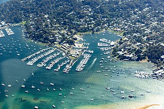
Newport is a suburb of northern Sydney in the state of New South Wales, Australia, in the local government area of Northern Beaches Council. It is part of the Northern Beaches region.

Bayview is a suburb in Sydney's Northern Beaches region, in the state of New South Wales, Australia 31 kilometres north of the Sydney central business district, in the local government area of Northern Beaches Council.

Mona Vale Hospital is located in the suburb of Mona Vale, on the Northern Beaches of metropolitan Sydney, Australia. It is a public hospital managed by New South Wales Health, and part of the Northern Sydney Local Health District.

Great Mackerel Beach is a suburb about 43 kilometres north of the Sydney central business district, from 2016 in the local government area of Northern Beaches Council, Sydney, New South Wales, Australia, formerly part of Pittwater Council. It is on the western shores of Pittwater in Ku-ring-gai Chase National Park, beside Currawong Beach, and near Coasters Retreat and Palm Beach. The population was 36 at the 2016 census; the median age was 66, with an average of 0.3 children per family and an average of 2 people per household. The population was 301 at the 2011 census, and 103 in 2006. Currently there are 55 permanent residents in 27 properties, with many additional residents occupying properties throughout school holidays and weekends.

Northern Sydney is a large metropolitan area in Sydney, New South Wales, Australia on the north shore of Sydney Harbour and Parramatta River. The region embraces suburbs in Sydney’s north-east, north and inner north west. Northern Sydney is divided into distinctive regions such as the North Shore, Northern Beaches and Forest District.

B-Line is a bus route operated by Keolis Downer Northern Beaches between the central business district and the Northern Beaches in Sydney, Australia.

The Northern Beaches Council is a local government area located in the Northern Beaches region of Sydney, in the state of New South Wales, Australia. The council was formed on 12 May 2016 after the amalgamation of Manly, Pittwater and Warringah Councils.


