Petersham, New South Wales

Last updated

Petersham
Sydney,  New South Wales
PetershamTH.JPG
Petersham Town Hall, Crystal Street
Petersham, New South Wales
Population8,116 (2016 census) [1]
 • Density6,291/km2 (16,290/sq mi)
Postcode(s) 2049
Elevation37 m (121 ft)
Area1.29 km2 (0.5 sq mi)
Location6 km (4 mi) south-west of Sydney CBD
LGA(s) Inner West Council
State electorate(s) Newtown
Federal division(s) Grayndler
Suburbs around Petersham:
Leichhardt Leichhardt Annandale
Lewisham Petersham Stanmore
Dulwich Hill Marrickville Enmore
Petersham railway building Petersham1.JPG
Petersham railway building

Petersham is a suburb in the Inner West [2] of Sydney, in the state of New South Wales, Australia. Petersham is located 6 kilometres south-west of the Sydney central business district, in the local government area of Inner West Council. [3] Petersham is known for its extensive Portuguese commercial offerings, with many Portuguese businesses and restaurants, although only 156 (1.9%) of the population was actually born in Portugal. [1]

Contents

Petersham is bordered by the suburbs of Leichhardt to the north, Stanmore to the east, Marrickville to the south and Lewisham to the west. Taverner's Hill, named after Fred Taverner, is a locality in the western part of the suburb.

History

Major Francis Grose sent workmen to the area in 1793 to clear the bush and plant corn and wheat. He named the area Peters-Ham or Petersham after his native village in Surrey, England. [ citation needed ] Petersham remained an agricultural area, winning awards for some of the best crops and stock in the colony in 1803. [ citation needed ] Kangaroo hunting was also popular in the area. The name was also used for the surrounding parish.

Robert Wardell (1793–1834) purchased land from many grantees in the district and in 1831 his estate eventually stretched 2,000 acres (8.1 km2) from Petersham to the Cooks River. Following his murder by escaped convicts in 1834, the estate was subdivided. The train line from Sydney to Parramatta opened in 1855 and trains stopped here from 1857. A platform was built in 1863. The original Petersham post office became Annandale in 1855. Another post office opened as Norwood in May 1860 and was moved to Petersham station in 1870. The first public school opened in 1878.

Petersham municipality was incorporated in 1872. The local council merged with Marrickville and St Peters in 1948 to form the Municipality of Marrickville. In 1916, the Boys' section of Fort Street High School moved to Petersham from Observatory Hill, followed by the Girls' section in 1975. [4]

Wartime plane crash

Mosquito HR576 RAF (UK) disintegrated over the inner western Sydney suburbs of Leichhardt and Petersham on 2 May 1945 during an air test flight. The crew of two were killed but no one on the ground was seriously injured by the falling debris of the Mosquito. The Daily Telegraph of 3 May 1945 stated that two civilians were injured and a total of 18 properties were damaged. Five houses were set on fire by the falling debris. [5]

It was suspected that a violent pull out from a power dive, with its associated high 'g' forces may have led to the structural failure of the aircraft. The two crew members tried to escape from the aircraft but they were not high enough for their parachutes to open. Flight Lieutenant David Rochford of Oxford, England, and Leading Aircraftman (LAC) Charles Boydell from Mosman were both killed. Flight Lieutenant Rochford's body was found in the playground of Petersham Public School while LAC Boydell's body was found on the roof of a railway building about 100 metres away. [6]

Heritage listings

Petersham has a number of heritage-listed sites, including:

Commercial area

A small row of shops lines New Canterbury Road and extends down Audley Street towards the railway station. There are some Portuguese businesses here including several Portuguese restaurants, some of which are renowned for selling traditional styled flame-grilled chicken and cod dishes Petersham is considered the heart of Sydney's Portuguese community. [10]

Local landmarks include the Petersham Town Hall, the Petersham Reservoir and Petersham Park. Petersham is bordered by Parramatta Road to the north.

Transport

Petersham railway station is on the Inner West & Leppington Line of the Sydney Trains network. Travelling west, all stations services run from the City Circle to Homebush and Parramatta. The station includes an ornate iron pedestrian bridge over the train line. The old station building was built in 1886 in the Victorian Free Classical style. It has been described as "the largest and grandest of the surviving 19th century railway stations in the Sydney area", and is listed on the Register of the National Estate. [11] [12]

The 428, 444, 445 and 412 buses run through Petersham at different points. The 428 runs from Canterbury to Circular Quay, the 444 and 445 run from Campsie to Balmain, and the 412 runs from Campsie to King Street Wharf in the city.

Schools

Fort Street High School, located on Parramatta Road, is the oldest selective school in New South Wales and has 934 students as of 2013. Petersham Public School sits on the Petersham and Lewisham borders, and has 240 students as at 2014. The old public school building located in Gordon Street goes back to 1878. Along with the church in the grounds, it is listed on the Register of the National Estate. [13] Taverners Hill Public School situated on Elswick Street, is an infants only school with 60 students and recently published its own cook book. [14]

All Saints Anglican Church AllSaints AnglicanChurch Petersham CornerView.jpg
All Saints Anglican Church

Churches

Architecture

Petersham's houses are predominantly terrace houses, similar to those of Summer Hill and Stanmore on the north side of the railway station near Parramatta Road.

Demographics

Historical population
YearPop.±%
20016,567    
20067,391+12.5%
20117,529+1.9%
20168,116+7.8%

According to the 2016 census of Population, there were 8,116 people in Petersham.

[1]

Notable residents

Culture

Local events include the annual Audley Street festival (Bairro Português [15] ), which is a celebration of the suburb's Portuguese ties. Petersham is also home to the Petersham Bowling Club and Petersham RSL Club.

Related Research Articles

Hurlstone Park Suburb of Sydney, New South Wales, Australia

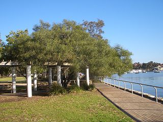
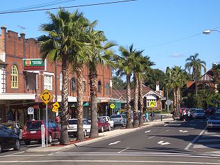
Hurlstone Park is a suburb in the Inner West of Sydney, New South Wales, Australia. Hurlstone Park is located nine kilometres south-west of the Sydney central business district and is mostly in the local government area of the City of Canterbury-Bankstown, and partly in the Inner West Council. The suburb is bounded by: the Cooks River to the south, Garnet Street to the east, New Canterbury Road to the north, Canterbury Road to the north-west, and Church Street to the west.

Inner West Region in New South Wales, Australia

The Inner West of Sydney is an area directly west of the Sydney central business district, New South Wales, Australia. The suburbs that make up the Inner West are predominantly located along the southern shore of Port Jackson, stretching south to the shores of the Cooks River. The western boundary of the Inner West is approximately the A3 arterial road, which divides the Inner West from the Greater Western Sydney region. The Inner West is much larger than the Inner West Council local government area. The Inner West roughly corresponds with the Parish of Petersham and Parish of Concord, two cadastral divisions used for land titles.

Leichhardt, New South Wales Suburb of Sydney, New South Wales, Australia

Leichhardt is a suburb in the Inner West of Sydney, in the state of New South Wales, Australia. Leichhardt is located 5 kilometres west of the Sydney central business district (CBD) and is the administrative centre for the local government area (LGA) of the Inner West Council. The suburb is bordered by Haberfield to the west, Annandale to the east, Lilyfield to the north and Petersham, Lewisham and Stanmore to the south.

Ashfield, New South Wales Suburb of Sydney, New South Wales, Australia

Ashfield is a suburb in the Inner West of Sydney, in the state of New South Wales, Australia. Ashfield is about 8 kilometres west of the Sydney central business district.

Summer Hill, New South Wales Suburb of Sydney, New South Wales, Australia

Summer Hill is a suburb of Sydney, in the state of New South Wales, Australia. Summer Hill is located 7 kilometres west of the Sydney central business district, in the local government area of the Inner West Council.

Haberfield, New South Wales Suburb of Sydney, New South Wales, Australia

Haberfield is a suburb in the Inner West of Sydney, in the state of New South Wales, Australia. Haberfield is located 6.5 kilometres west of the Sydney central business district in the local government area of the Inner West Council.

Lilyfield, New South Wales Suburb of Sydney, New South Wales, Australia

Lilyfield is a suburb in the Inner West of Sydney, in the state of New South Wales, Australia. Lilyfield is located 6 kilometres west of the Sydney central business district, in the local government area of the Inner West Council.

Marrickville, New South Wales Suburb of Sydney, New South Wales, Australia

Marrickville is a suburb in the Inner West of Sydney, in the state of New South Wales, Australia. Marrickville is located 7 kilometres south-west of the Sydney central business district and is the largest suburb in the Inner West Council local government area.

Lewisham, New South Wales Suburb of Sydney, New South Wales, Australia

Lewisham is a suburb in the Inner West of Sydney, in the state of New South Wales, Australia. Lewisham is located 7 kilometres south-west of the Sydney central business district, in the local government area of Inner West Council. The postcode is 2049. Lewisham is surrounded by the suburbs of Petersham, Dulwich Hill, Summer Hill, Haberfield and Leichhardt.

Dulwich Hill, New South Wales Suburb of Sydney, New South Wales, Australia

Dulwich Hill is a suburb in the Inner West of Sydney, in the state of New South Wales, Australia. It is 7.5 kilometres south-west of the Sydney central business district, in the local government area of Inner West Council. Dulwich Hill stretches south to the shore of the Cooks River.

Stanmore, New South Wales Suburb of Sydney, New South Wales, Australia

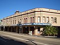
Stanmore is a suburb in the Inner West of Sydney, in New South Wales, Australia 6 kilometres south west of the Sydney central business district. It is part of the local government area of the Inner West Council. It is known for its long strip of shops running along Parramatta Road.

Croydon, New South Wales Suburb of Sydney, New South Wales, Australia

Croydon is a suburb in the Inner West of Sydney, in the state of New South Wales, Australia. It is located 9 kilometres (5.6 mi) west of the Sydney central business district. Croydon is split between the two local government areas of Municipality of Burwood and the Inner West Council.

Canterbury, New South Wales Suburb of Sydney, New South Wales, Australia

Canterbury is a suburb extending across south-western Sydney and the Inner West, in the state of New South Wales, Australia. Canterbury is located 10.5 kilometres (6.5 mi) south-west of the Sydney central business district in the City of Canterbury-Bankstown.

Erskineville, New South Wales Suburb of Sydney, New South Wales, Australia

Erskineville is an inner-city suburb of Sydney, in the state of New South Wales, Australia. It is located 6 kilometres south west of the Sydney central business district and is part of the local government area of the City of Sydney. Erskineville is a diverse suburb homing to a wide variety of ethnicity from its varying Southeast Europe and Aboriginal community. Erskineville is colloquially known as Erko.

Sydenham, New South Wales Suburb of Sydney, New South Wales, Australia

Sydenham is a suburb in the Inner West of Sydney, in the state of New South Wales, Australia. Sydenham is located 8 kilometres south of Sydney central business district and is part of the local government area of Inner West Council. Sydenham is surrounded by the suburbs of Marrickville, St Peters and Tempe.

Lidcombe Suburb of Sydney, New South Wales, Australia

Lidcombe is a suburb in western Sydney, in the state of New South Wales, Australia. Lidcombe is located 15 km (9.32 mi) west of the Sydney central business district, in the local government area of Cumberland Council, with a small industrial part in the north in the City of Parramatta.

Earlwood, New South Wales Suburb of Sydney, New South Wales, Australia

Earlwood is a suburb in South Western Sydney, in the state of New South Wales, Australia. Earlwood is located 10 kilometres south-west of the Sydney central business district, in the local government area of the City of Canterbury-Bankstown.

Petersham Reservoir

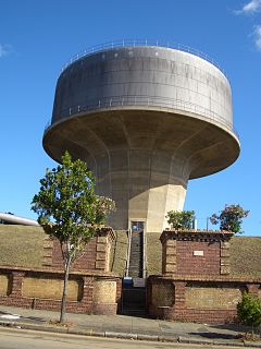
Petersham Reservoir is a heritage-listed water reservoir at New Canterbury Road, Petersham, Inner West Council, Sydney New South Wales, Australia. It was designed and built by the New South Wales Public Works Department. It is also known as Petersham Service Reservoir and WS089. The property is owned by Sydney Water. It was added to the New South Wales State Heritage Register on 18 November 1999.

Ashfield Reservoir Dam

The Ashfield Reservoir is a heritage-listed reservoir located at Holden Street, Ashbury, City of Canterbury-Bankstown, New South Wales, Australia. It was designed and built by the Metropolitan Board of Water Supply and Sewerage. It is also known as Ashfield Reservoir (Elevated) and WS 0003. The property is owned by Sydney Water. It was added to the New South Wales State Heritage Register on 15 November 2002.

References

  1. 1 2 3 Australian Bureau of Statistics (27 June 2017). "Petersham (State Suburb)". 2016 Census QuickStats. Retrieved 14 December 2017. OOjs UI icon edit-ltr-progressive.svg
  2. Australian Suburb Guide: Sydney Inner West Archived 26 December 2012 at the Wayback Machine . Retrieved 8 August 2013.
  3. Gregory's Sydney Street Directory, Gregory's Publishing Company, 2007
  4. The Book of Sydney Suburbs, Frances Pollen, Angus & Robertson Publishers, 1990, Published in Australia ISBN   0-207-14495-8
  5. "Plane Explodes in Air Over Petersham, Falls on Homes". The Sun . No. 11,007. Sydney. 2 May 1945. p. 3 (Late Final Extra). Retrieved 3 September 2016 via National Library of Australia.
    "Wreckage Falls on Petersham Home". The Sun . No. 11,007. Sydney. 2 May 1945. p. 3 (Late Final Extra). Retrieved 3 September 2016 via National Library of Australia.
    "Plane Blows Up OVer Petersham". Goulburn Evening Post . New South Wales. 3 May 1945. p. 2 (Daily and Evening). Retrieved 3 September 2016 via National Library of Australia.
  6. "About Petersham College | TAFE Sydney Institute". Sit.nsw.edu.au. Archived from the original on 27 March 2012. Retrieved 22 August 2013.
  7. "Petersham Service Reservoir & Site". New South Wales State Heritage Register . Office of Environment & Heritage. H01331. Retrieved 18 May 2018.
  8. "Egyptian Room Scottish Temple". New South Wales State Heritage Register . Office of Environment & Heritage. H00118. Retrieved 18 May 2018.
  9. "Petersham Railway Station group". New South Wales State Heritage Register . Office of Environment & Heritage. H01223. Retrieved 18 May 2018.
  10. "Sydney, via Portugal and Greece". The Australian . 21 July 2012. Retrieved 22 January 2018.
  11. The Heritage of Australia, Macmillan Company, 1981
  12. "Petersham Railway Station Group". NSW Environment & Heritage.
  13. The Heritage of Australia
  14. Taverners Hill Cookbook ISBN   978-0-646-48367-2
  15. "Bairro Português". Inner West Council. Retrieved 24 August 2021.

Coordinates: 33°53′46″S151°09′15″E / 33.8961°S 151.1543°E / -33.8961; 151.1543