Sydenham, New South Wales

Last updated

Sydenham
Sydney,  New South Wales
Sydney R class no 1923 at Sydenham, 20 November 1954..jpg
R class tram no 1923 at Sydenham railway station, 20 November 1954. Trams in Sydney services.
Sydenham, New South Wales
Population1,100 (SAL 2021) [1]
Postcode(s) 2044
Location8 km (5 mi) south of Sydney CBD
LGA(s) Inner West Council
State electorate(s) Heffron
Federal division(s) Grayndler
Suburbs around Sydenham:
Marrickville Marrickville St Peters
Marrickville Sydenham St Peters
Tempe Tempe St Peters
Sydenham Green SydenhamPark1.jpg
Sydenham Green
Sydenham Green SydenhamPark2.jpg
Sydenham Green

Sydenham is a suburb in the Inner West [2] of Sydney, in the state of New South Wales, Australia. Sydenham is located 8 kilometres south of Sydney central business district and is part of the local government area of Inner West Council. Sydenham is surrounded by the suburbs of Marrickville, St Peters and Tempe.

Contents

History

Former St Peters Town Hall on Unwins Bridge Road in Sydenham. Sydenham Town Hall.JPG
Former St Peters Town Hall on Unwins Bridge Road in Sydenham.

Sydenham developed after the Illawarra railway line came through the area to Hurstville in the late 1800s. It was named after Sydenham, a suburb of London, for their similarities in their close proximity to the city and a railway junction. The station was originally known as Marrickville when it opened on 15 October 1884. It was changed to Sydenham on 19 March 1895 when a new line was being built to Bankstown and the first station was to be called Marrickville. The post office opened in April 1899 as Tempe Park and was only renamed Sydenham in 1964. [3]

Marrickville Council proposed the Sydenham Creative Hub—a commercial area of bars, cafes and galleries—near Sydenham Station sometime after 2011. On 12 December 2017, the Inner West Council voted to shrink the proposed precinct to an area immediately adjacent to the Station only. [4]

Sydenham has a number of heritage-listed sites, including Sydenham railway station. [5]

Population

In the 2016 Census, there were 1,145 people in Sydenham. 51.9% of people were born in Australia and 51.0% of people only spoke English at home. The most common responses for religion were No Religion, 35.6%, Catholic 20.1%, Buddhism 11.9%, Not stated 9.3% and Eastern Orthodox 6.7%. [6]

Transport

Sydenham railway station is a junction for three lines on the Sydney Trains network: the Illawarra, Airport & South and Bankstown lines, and contains a Sydney Metro line under construction as of 2023.

Former tram/light rail service

A cross country line connected the Cooks River Line and the Dulwich Hill line via Sydenham, operating along Railway Road and Sydenham Road in Sydenham.

Features

Sydenham is a small suburb extending southeast from the railway station to the Princes Highway. It has a mixture of residential and industrial developments. A small group of shops is located around the intersection of Unwins Bridge Road and Railway Road, close to Sydenham railway station. In the adjacent suburb of Marrickville, commercial developments are also located along Sydenham and Marrickville Roads close to the border with Sydenham. Marrickville Metro Shopping Centre is also very close to Sydenham.

Sydenham Green

Sydenham is directly under the flight path of Sydney Airport. To deal with noise complaints from residential properties between Unwins Bridge Road and the Princes Highway, the government compulsory acquired these properties and converted them into a recreational park. [7] The park occupies a large portion of the small suburb. Sydenham Green is located on either side of Railway Road, named after the park of the same name in Sydenham, London. Two heritage buildings along Railway Road were retained, a sandstone terrace house and St Marys Church (which was later controversially demolished after a suspicious fire. [8] ) In the park, a series of oversized 'living room' sculptures – lamp, chairs and fireplace pays homage to the residential houses that formerly occupied the site.

Schools and Churches

Schools close to Sydenham are St Pius Catholic School , Enmore Road - Near Marrickville Metro, Tempe High School (Sydney) and Tempe Public School. St Mary's Church was the first Coptic Church outside of Egypt, but was demolished in 2017. [8]

Related Research Articles

<span class="mw-page-title-main">Hurlstone Park</span> Suburb of Sydney, New South Wales, Australia

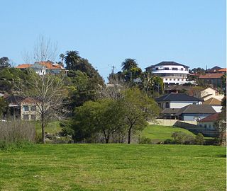
Hurlstone Park is a suburb in the Inner West of Sydney, New South Wales, Australia. Hurlstone Park is located nine kilometres south-west of the Sydney central business district and is mostly in the local government area of the City of Canterbury-Bankstown, and partly in the Inner West Council. The suburb is bounded by: the Cooks River to the south, Garnet Street to the east, New Canterbury Road to the north, Canterbury Road to the north-west, and Church Street to the west.

<span class="mw-page-title-main">Inner West</span> Region in New South Wales, Australia

The Inner West of Sydney is an area directly west of the Sydney central business district, New South Wales, Australia. The suburbs that make up the Inner West are predominantly located along the southern shore of Port Jackson, stretching south to the shores of the Cooks River. The western boundary of the Inner West is approximately the A3 arterial road, which divides the Inner West from the Greater Western Sydney region. The Inner West is much larger than the Inner West Council local government area. The Inner West roughly corresponds with the Parish of Petersham and Parish of Concord, two cadastral divisions used for land titles.

<span class="mw-page-title-main">Panania</span> Suburb of Sydney, New South Wales, Australia

Panania, a suburb of local government area City of Canterbury-Bankstown, is located 23 kilometres inner south-west of the Sydney central business district, in the state of New South Wales, Australia, and is a part of the South-western Sydney region. The postcode is 2213, which it shares with adjacent suburbs East Hills and Picnic Point.

<span class="mw-page-title-main">Marrickville, New South Wales</span> Suburb of Sydney, New South Wales, Australia

Marrickville is a suburb in the Inner West of Sydney, in the state of New South Wales, Australia. Marrickville is located 7 kilometres south-west of the Sydney central business district and is the largest suburb in the Inner West Council local government area.

<span class="mw-page-title-main">Dulwich Hill</span> Suburb of Sydney, New South Wales, Australia

Dulwich Hill is a suburb in the Inner West of Sydney, in the state of New South Wales, Australia. It is 7.5 kilometres south-west of the Sydney central business district, in the local government area of Inner West Council. Dulwich Hill stretches south to the shore of the Cooks River.

<span class="mw-page-title-main">Burwood, New South Wales</span> Suburb of Sydney, New South Wales, Australia

Burwood is a suburb in the Inner West of Sydney, in the state of New South Wales, Australia. It is 10 kilometres (6.2 mi) west of the Sydney central business district and is the administrative centre for the local government area of Municipality of Burwood. People from Burwood are colloquially known as Burwoodiens or Burwooders.

<span class="mw-page-title-main">Sydenham railway station, Sydney</span> Railway station in Sydney, New South Wales, Australia

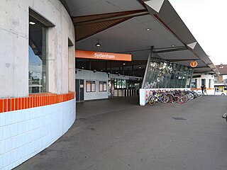
Sydenham railway station is a heritage-listed railway station located on the Illawarra line, serving the Sydney suburb of Sydenham in New South Wales, Australia. It is served by Sydney Trains T3 Bankstown, T4 Illawarra and T8 South services. It was designed by the New South Wales Government Railways and built from 1884 to 1962, with William Robinson having built the original 1884 buildings. It was added to the New South Wales State Heritage Register on 2 April 1999.

<span class="mw-page-title-main">Canterbury, New South Wales</span> Suburb of Sydney, New South Wales, Australia

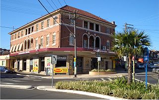
Canterbury is a suburb of south-western Sydney, in the state of New South Wales, Australia. Canterbury is located 10.5 kilometres (6.5 mi) south-west of the Sydney central business district in the City of Canterbury-Bankstown.

<span class="mw-page-title-main">Tempe, New South Wales</span> Suburb of Sydney, New South Wales, Australia

Tempe is a suburb in the Inner West of Sydney, in the state of New South Wales, Australia. Tempe is located 9 kilometres south of the Sydney central business district in the local government area of Inner West Council.

<span class="mw-page-title-main">Undercliffe, New South Wales</span> Place in New South Wales, Australia

Undercliffe is an eastern section of the suburb of Earlwood located in South Western Sydney, New South Wales, Australia. Undercliffe is situated 10 kilometres south-west of the Sydney central business district within the local government area of the City of Canterbury-Bankstown.

<span class="mw-page-title-main">Bankstown Line</span> Commuter rail line in Sydney, New South Wales, Australia

The Bankstown Line is a commuter rail line operated by Sydney Trains in Sydney, New South Wales, Australia. It serves Canterbury-Bankstown and parts of the Inner West and Western Sydney. The Bankstown railway line is the physical railway line which carries the section of the Bankstown Line between Sydenham and Birrong.

<span class="mw-page-title-main">Erskineville</span> Suburb of Sydney, New South Wales, Australia

Erskineville is an inner-city suburb of Sydney, in the state of New South Wales, Australia. It is located 6 kilometres south west of the Sydney central business district and is part of the local government area of the City of Sydney. Erskineville is a diverse suburb homing to a wide variety of ethnicity from its varying Southeast Europe and Aboriginal community. Erskineville is colloquially known as Erko.

<span class="mw-page-title-main">Belmore railway station</span> Railway station in Sydney, New South Wales, Australia

Belmore railway station is a heritage-listed railway station located on the Bankstown line at Burwood Road, Belmore in the City of Canterbury-Bankstown local government area of New South Wales, Australia. It is served by Sydney Trains T3 Bankstown line services. It was designed and built by NSW Government Railways from 1895 to 1937. It is also known as Belmore Railway Station Group and Burwood Road. The property was added to the New South Wales State Heritage Register on 2 April 1999.

<span class="mw-page-title-main">Marrickville railway station</span> Railway station in Sydney, New South Wales, Australia

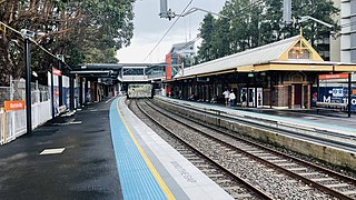
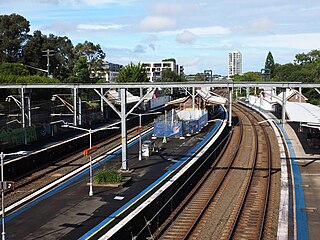
Marrickville railway station is located on the Bankstown railway line, serving the Sydney suburb of Marrickville. It is served by Sydney Trains T3 Bankstown line services. It was added to the New South Wales State Heritage Register on 2 April 1999.

<span class="mw-page-title-main">St Peters, New South Wales</span> Suburb of Sydney, New South Wales, Australia

St Peters is a suburb in the Inner West of Sydney, in the state of New South Wales, Australia. It is 7 kilometres south of the Sydney central business district, in the local government area of Inner West Council, with a small section in the southeast in the City of Sydney.

<span class="mw-page-title-main">Campsie, New South Wales</span> Suburb of Sydney, New South Wales, Australia

Campsie is a suburb in the state of New South Wales, Australia. Campsie is 11 kilometres south west of the Sydney central business district, on the southern bank of the Cooks River. Campsie is one of the administrative centres of the City of Canterbury-Bankstown.

<span class="mw-page-title-main">Earlwood, New South Wales</span> Suburb of Sydney, New South Wales, Australia

Earlwood is a suburb of Sydney, in the state of New South Wales, Australia. Earlwood is located 10 kilometres south-west of the Sydney central business district, and is part of the Canterbury-Bankstown area. It is in the local government area of the City of Canterbury-Bankstown.

<span class="mw-page-title-main">Erskineville railway station</span> Railway station in Sydney, New South Wales

Erskineville railway station is located on the Illawarra line, serving the Sydney suburb of Erskineville. It is served by Sydney Trains T3 Bankstown line services.

<span class="mw-page-title-main">Sydney Freight Network</span> Railway line in Sydney, New South Wales, Australia

The Sydney Freight Network is a network of dedicated railway lines for freight in Sydney, Australia, linking the state's rural and interstate rail network with the city's main yard at Enfield and Port Botany. Its primary components are the Southern Sydney Freight Line (SSFL) and a line from Sefton to Enfield and Port Botany. The Network has been managed by the Australian Rail Track Corporation (ARTC) since 2012. Prior to the completion of the SSFL, it was managed by RailCorp as the Metropolitan Freight Network.

<span class="mw-page-title-main">Bankstown railway line</span> Railway line in Sydney, New South Wales, Australia

The Bankstown railway line is a railway line serving the Canterbury-Bankstown and Inner West regions of Sydney between the stations of Sydenham and Lidcombe.

References

  1. Australian Bureau of Statistics (28 June 2022). "Sydenham (NSW) (Suburb and Locality)". Australian Census 2021 QuickStats. Retrieved 28 June 2022.  OOjs UI icon edit-ltr-progressive.svg
  2. Australian Suburb Guide: Sydney Inner West Archived 26 December 2012 at the Wayback Machine . Retrieved 7 August 2013.
  3. The Book of Sydney Suburbs, Compiled by Frances Pollon, Angus & Robertson Publishers, 1990, Published in Australia ISBN   0-207-14495-8, page 251
  4. "Sydenham Station Creative Hub Planning Proposal". 28 February 2018. Retrieved 4 March 2018.
  5. "Sydenham Railway Station group". New South Wales State Heritage Register . Department of Planning & Environment. H01254. Retrieved 18 May 2018. CC BY icon.svg Text is licensed by State of New South Wales (Department of Planning and Environment) under CC-BY 4.0 licence .
  6. Australian Bureau of Statistics (27 June 2017). "Sydenham (State Suburb)". 2016 Census QuickStats. Retrieved 14 September 2017. OOjs UI icon edit-ltr-progressive.svg
  7. Sydenham Green, Sydenham Sydney's Inner West
  8. 1 2 "End to fight as church razed" . Retrieved 28 November 2017.

33°55′5″S151°9′48″E / 33.91806°S 151.16333°E / -33.91806; 151.16333