Mosman, New South Wales

Last updated

Mosman
Sydney,  New South Wales
(1)Mosman houses from ferry.jpg
View of Mosman from the Mosman ferry
Mosman, New South Wales
Mosman
Population28,475 (2016 census) [1]
 • Density3,273/km2 (8,480/sq mi)
Postcode(s) 2088
Elevation79 m (259 ft)
Area8.7 km2 (3.4 sq mi)
Location8 km (5 mi) NE of Sydney CBD
LGA(s) Mosman Council
State electorate(s) North Shore
Federal division(s) Warringah
Suburbs around Mosman:
Northbridge Seaforth Clontarf
Cremorne Mosman
Cremorne Point

Mosman is a suburb on the Lower North Shore region of Sydney, in the state of New South Wales, Australia. Mosman is located 8 kilometres north-east of the Sydney central business district and is the administrative centre for the local government area of the Municipality of Mosman.

Contents

Localities

In February 1997, a notice was published in the Government Gazette by Mosman Council advising that they had assigned Mosman as the only suburb in the Mosman Local Government Area. However, Mosman Council decided that residents should continue to be allowed to use the following traditional locality names if they wished: [2]

History

Mosman is named after Archibald Mosman (17991863) and his twin brother George, who moved onto a 4-acre (16,000 m2) land grant in the area in 1831. They were involved in shipping, and founded a whaling station on a bay in the harbour, which became known as Mosman's Bay. George subsequently became involved in grazing, but Archibald continued with whaling activities. By 1838, he owned 108 acres (0.44 km2) along the Mosman waterfront. [3] Archibald was buried in the cemetery of St Jude's Church, Randwick. His grave is maintained by Mosman Council.

Arthur Streeton, Mosman's Bay, 1914 Arthur Streeton - Mosman's Bay, 1914.jpg
Arthur Streeton, Mosman's Bay, 1914

Aboriginal culture

Mosman was originally inhabited by the Borogegal tribe. [4] Bungaree (c. 17751830) was a well known Aboriginal who joined British explorers on voyages, including circumnavigating Australia with Matthew Flinders when he was 26. He later became leader of his tribe, was given land at Georges Head, and enjoyed the patronage of Governor Lachlan Macquarie. He greeted newcomers whose ships entered Port Jackson, and became acquainted with Russian and French explorers. His image was painted many times and shown in London, Paris, and Moscow.

European settlement

A gun emplacement at Middle Head Fort Midheadfort.jpg
A gun emplacement at Middle Head Fort

In 1789 HMS Sirius—the flagship of the First Fleet—entered what is now known as Mosman Bay or Great Sirius Cove. Mosman has been the site of important maritime and defence installations for Sydney since 1801, especially when Sydney's Harbour defences were expanded with the construction of Middle Head Fort, Georges Head Battery and Bradleys Head Fortification Complex. In 1871 the Beehive Casemate was constructed into the cliff side on Obelisk Bay. [5]

A Submarine Miners' Depot was constructed at Chowder Bay (Georges Head) in the 1880s. In 1888 the site was modified for the latest in harbour defences. The site was a strategic position and considered the best place to observe and fire mines which were laid underwater. Minefields were laid across the main shipping channels of Port Jackson from 1876 to 1922 and a base was built at Chowder Bay for the submarine miners (Clifton Gardens). From Georges Head, miners watched for ships entering the harbour. Their job was to explode the mine closest to an approaching enemy ship. Each underwater mine was attached to an electric cable that ran up the cliff to the firing post. [6] [7] During a demonstration in 1891, a crowd of several thousand people watched as a fatal accident killed four miners and injured another eight.

Mosman's Bay by John Mather, 1889 Mosmans Bay John Mather 1889.png
Mosman's Bay by John Mather, 1889

In the 1880s and 1890s, as a result of the enthusiasm for painting en plein air fostered by the Barbizon and Impressionist movements in France, art colonies known as the Sydney artists' camps flourished around the Harbour, mainly in the Mosman area. [8] As a result, Mosman became known as "Australia's most painted suburb". [9] Notable painters in this community included Julian Ashton, Tom Roberts, Arthur Streeton and John Mather. One such camp was known as Curlew Camp and was situated in Little Sirius Cove. An inscription on a rock can still be seen on the east side of the cove: Curlew 1890.

In 1942 during the Second World War the Sydney Harbour anti-submarine boom net was constructed on Georges Head and was designed to prevent enemy submarines from entering into Sydney Harbour. The boom net spanned the entire width of Port Jackson and a boom net winch house was located on Liangs Point, Watsons Bay. On the night of 31 May 1942, three Japanese midget submarines attempted to enter Sydney Harbour in what became known as the attack on Sydney Harbour. [10] [11] One of the Japanese midget submarines became entangled in the boom net and after unsuccessful attempts by the crew to free the submarine they detonated charges within the sub, killing themselves and destroying their sub in the process.

The 1916 James Barry Zoo entrance building Taronga Zoo entrance.jpg
The 1916 James Barry Zoo entrance building

Chowder Bay was used in the late 1820s as an anchorage for visiting American whaling ships. [4] In 1831 Archibald Mosman and John Bell were allotted grants of land in Mosman Bay to establish a whaling station. The only remaining building of the original whaling station is The Barn in Avenue Road. The Barn was a store and sail drying house. It is now the home of the 1st Mosman 1908 Scout Group.

Mosman War Memorial, designed by Peter Kaad, and Allan Border Oval Mosman 4.JPG
Mosman War Memorial, designed by Peter Kaad, and Allan Border Oval

A foot track ran from North Sydney to Middle Head in the 1840s. Avenue Road which ran from Mosman Bay to Mosman Junction was constructed in 1860 with Military Road, Middle Head Road, and Bradleys Head Road all constructed ten years later. [4] From the 1870s, land development spread settlement east from Milson's Point, including to the Mosman area, which was boosted with a regular ferry service around the same time. [12] Richard Harnett Senior purchased Archibald Mosman's original 108 acres (0.44 km2) in 1859 and in 1878 established a sandstone quarry at Mosman Bay. In 1871, he built a wharf and subsidised a ferry service between Mosman Bay, Neutral Bay, and Circular Quay. [13] He promoted a land development known as the Mosman Bay Estate; when the land was sold, the ferry service was cancelled, much to the annoyance of the new landowners. [14] His son, Richard Harnett Junior, was the first Mayor elected when Mosman became a municipality in 1893 with 1,600 residents, breaking away from the North Sydney municipality. [15] Both men were major influences in Mosman and were responsible for building many roads, a horse-drawn bus service and ferry services linking Mosman to the city. Mosman Public School opened in 1880.

Around the start of the 20th century, rows of shops and Federation architecture homes were built. Taronga Zoo opened in 1916, moving from a site at Moore Park that had been in use since 1884. Taronga is an Aboriginal word for 'beautiful view'. From the late 1950s, multi-storey flat developments began and became a public concern, leading to controls and restrictions being introduced.

Landmarks

Balmoral Beach Balmoral Beach clear.jpg
Balmoral Beach

Mosman forms a peninsula between Sydney Harbour and Middle Harbour. It features a number of harbour beaches, including Balmoral, Chinamans Beach and two legally-designated clothing optional beaches: Obelisk Beach and Cobblers Beach. Other attractions include Taronga Zoo, Bradleys Head and sections of Sydney Harbour National Park. [16] Overlooking the harbour, in Rawson Park, is the Scotland Australia Cairn comprising a stone sourced from every parish in Scotland. It is a memorial to the Scottish pioneers who contributed much to Australia and was a gift from Scotland at the time of the Bicentennial Celebrations in 1988. [17] Highland games are held there, usually the day after St Andrew's Day celebrations. On the eastern shore of Sirius Cove is the site of Curlew Camp where artists such as Arthur Streeton and Tom Roberts once resided. The council has recently constructed the Curlew Camp Artists Walk. Ashton Park is a popular attraction and includes Athol Hall which provides a venue for events and has a café which is open seven days a week.

Heritage listings

Mosman has a number of heritage-listed sites, including:

Houses

Mosman is primarily a residential suburb. Federation era houses predominate but there are also other styles ranging from California bungalow to modern townhouse and apartment buildings.

At the 2016 census, 51.7% of occupied private dwellings were flats or apartments. Another 35.4% were separate houses, and 12.1% were semi-detached. [1]

Average house prices in Mosman are among the highest in Australia. In February 2016, the median purchase prices ranged from $606K for a 1-bedroom unit to $3.11M for a 4-bedroom house. [36] Average rents in October 2017 were $1,695 per week. [37]

Commercial area

"The Strand" on the conservation area shopping strip. Mosman 9.JPG
"The Strand" on the conservation area shopping strip.

Mosman's shopping centre is located along Military Road, which features many boutiques, cafes and restaurants. The shopping centre extends from the intersection with Bradley's Head Road and Middle Head Road and continues north up past the intersection with Spit Road at Spit Junction. It continues for some distance along both Spit Road and Military Road and extends down some of the side streets. Mosman Council has identified the early 20th century shopping strip along Military Road as a conservation area. The awnings along the street were originally column-supported. [38] A small shopping mall called Bridgepoint is located at Spit Junction. The Military Road Conservation Area also includes the row of shops at 581-595 Military Road, on the southern side of Military Road between the Town Hall and the Library Walk shopping complex. These shops, built from 1900 to 1904, were designed by Henry Austin Wilshire, and are included on the NSW Heritage database. [39]

Demographics

At the 2016 census, the suburb of Mosman recorded a population of 28,475. Of these: [1]

Age distribution
The distribution of ages in Mosman was older than the country as a whole. Mosman residents' median age was 42 years, compared to the national median of 38. Children aged under 15 years made up 17.6% of the population (national average is 18.7%) and people aged 65 years and over made up 19.1% of the population (national average is 15.8%).
Ethnic diversity
59.6% of people were born in Australia. The most common other countries of birth were England 8.5%, New Zealand 2.8%, United States 1.9%, China 1.8% and South Africa 1.7%. 77.9% of people only spoke English at home. Other languages spoken at home included Mandarin 2.2%, Spanish 1.2%, French 1.1%, Cantonese 0.9% and Italian 0.9%.
Religion
The most common responses for religion were No Religion 31.3%, Catholic 23.9% and Anglican 20.1%.
Finances
The median weekly household income was $2,522, compared to the national median of $1,438. Real estate costs were correspondingly high; the median mortgage repayments were $3,000 compared to the national median of $1,755. The median rent was $560 per week. [1] Kurt Iveson, a lecturer in the school of geosciences at Sydney University, said in 2020 that the average taxable income for all private households in Mosman was $169,218, compared to the $72,204[ citation needed ] taxable average income in Sydney's Census Metropolitan Area. [40]
Housing
67.7% were family households, 29.4% were single person households and 2.9% were group households. The average household size was 2.4 people.

Education

Schools in Mosman include:

Places of worship

Places of worship in Mosman include:

Sport and recreation

Sporting Clubs serving the Mosman community include:

Australian Test cricket captains Allan Border and Ian Craig grew up in Mosman and played for the local club.

Culture

Related Research Articles

<span class="mw-page-title-main">The Rocks, New South Wales</span> Suburb of Sydney, New South Wales, Australia


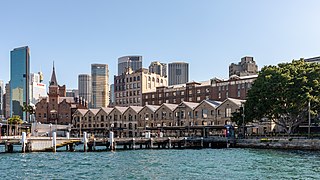
The Rocks is a suburb, tourist precinct and historic area of Sydney's city centre, in the state of New South Wales, Australia. It is located on the southern shore of Sydney Harbour, immediately north-west of the Sydney central business district.

<span class="mw-page-title-main">Hunters Hill, New South Wales</span> Suburb of Sydney, New South Wales, Australia

Hunters Hill is a suburb of the lower north shore of Sydney, in the state of New South Wales, Australia. Hunters Hill is located 9 kilometres (5.6 mi) north-west of the Sydney central business district and is the administrative centre for the local government area of the Municipality of Hunter's Hill.

<span class="mw-page-title-main">Randwick, New South Wales</span> Suburb of Sydney, New South Wales, Australia

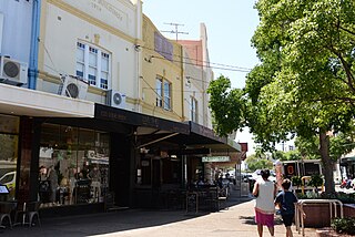
Randwick is a suburb in the Eastern Suburbs of Sydney, in the state of New South Wales, Australia. Randwick is located 6 kilometres south-east of the Sydney central business district and is the administrative centre for the local government area of the City of Randwick. The postcode is 2031.

<span class="mw-page-title-main">North Sydney, New South Wales</span> Suburb of Sydney, New South Wales, Australia

North Sydney is a suburb and major commercial district on the Lower North Shore of Sydney, Australia. North Sydney is located three kilometres north of the Sydney central business district and is the administrative centre for the local government area of North Sydney Council.

<span class="mw-page-title-main">City of Willoughby</span> Local government area in New South Wales, Australia

The City of Willoughby is a local government area on the Lower North Shore of Northern Sydney, in the state of New South Wales, Australia. It is located 6 kilometres (3.7 mi) north of the Sydney central business district. It was first proclaimed in October 1865 as the Municipality of North Willoughby.

<span class="mw-page-title-main">Double Bay, New South Wales</span> Suburb of Sydney, New South Wales, Australia

Double Bay is a harbourside eastern suburb of Sydney, in the state of New South Wales, Australia 4 kilometres east of the Sydney central business district. It is the administrative centre of the local government area of the Municipality of Woollahra.

<span class="mw-page-title-main">Cremorne, New South Wales</span> Suburb of Sydney, New South Wales, Australia

Cremorne is a suburb on the Lower North Shore of Sydney, New South Wales, Australia, located 6 kilometres north-east of the Sydney central business district, in the local government area of North Sydney Council.

<span class="mw-page-title-main">Vaucluse, New South Wales</span> Suburb of Sydney, New South Wales, Australia

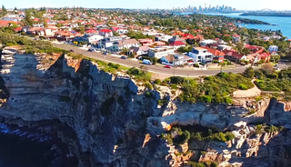
Vaucluse is an eastern suburb of Sydney, in the state of New South Wales, Australia. It is located 8 kilometres (5 mi) east of the Sydney central business district, in the local government areas of Waverley Council and the Municipality of Woollahra.

<span class="mw-page-title-main">City of Campbelltown (New South Wales)</span> Local government area in New South Wales, Australia

The City of Campbelltown is a local government area in the Macarthur region of south-western Sydney, in New South Wales, Australia. The area is located about 55 kilometres (34 mi) south west of the Sydney central business district and comprises 312 square kilometres (120 sq mi).

<span class="mw-page-title-main">Mosman Council</span> Local government area in New South Wales, Australia

Mosman Council is a local government area on the Lower North Shore of Sydney, New South Wales, Australia.

<span class="mw-page-title-main">North Sydney Council</span> Local government area in New South Wales, Australia

North Sydney Council is a local government area on the Lower North Shore of Sydney, New South Wales, Australia, established on 29 July 1890 through the amalgamation of three boroughs.

<span class="mw-page-title-main">Municipality of Woollahra</span> Local government area in New South Wales, Australia

Woollahra Municipal Council is a local government area in the eastern suburbs of Sydney, in the state of New South Wales, Australia. Woollahra is bounded by Sydney Harbour in the north, Waverley Council in the east, Randwick City in the south and the City of Sydney in the west.

<span class="mw-page-title-main">Millers Point, New South Wales</span> Suburb of Sydney, New South Wales

Millers Point is an inner-city suburb of Sydney, in the state of New South Wales, Australia. It is on the north-western edge of the Sydney central business district, adjacent to The Rocks and is part of the local government area of the City of Sydney.

<span class="mw-page-title-main">Darling Point</span> Suburb of Sydney, New South Wales, Australia

Darling Point is a harbourside eastern suburb of Sydney, Australia. It is 4 kilometres east of the Sydney central business district and is part of the local government area of Woollahra Council.

<span class="mw-page-title-main">Elizabeth Bay, New South Wales</span> Suburb of Sydney, New South Wales, Australia

Elizabeth Bay is a harbourside inner city eastern suburb of Sydney, in the state of New South Wales, Australia. Elizabeth Bay is located three kilometres east of the Sydney central business district and is part of the local government area of the City of Sydney.

<span class="mw-page-title-main">Georges Heights, New South Wales</span> Place in New South Wales, Australia

Georges Heights is an urban locality in the suburb of Mosman, adjoining Sydney, in the state of New South Wales, Australia. Georges Heights is located in the local government area of the Municipality of Mosman and is part of the Lower North Shore.

<span class="mw-page-title-main">Middle Head Fortifications</span> Historic site in New South Wales, Australia

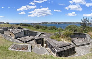
The Middle Head Fortifications is a heritage-listed former defence establishment and military fortifications and now public space located at Middle Head Road, Middle Head, Mosman in the Mosman Council local government area of New South Wales, Australia. It is also known as the Middle Head Military Fortifications or The Old Fort. The fortifications consist of the Outer Middle Head Battery located at the end of Old Fort Road, the Inner Middle Head Battery located at the end of Governors Road, and the Obelisk batteries reached by a path from the corner of Middle Head Road and Chowder Bay Road. The fortifications at Middle Head formed part of Sydney Harbour's defences. The property is owned by the NSW Office of Environment and Heritage. It was added to the New South Wales State Heritage Register on 2 April 1999.

<span class="mw-page-title-main">Bradleys Head Light</span> Lighthouse in New South Wales, Australia

The Bradleys Head Light is an active heritage-listed lighthouse at Bradleys Head, a headland protruding from the north shore of Sydney Harbour, within Mosman, Mosman Council, Sydney, New South Wales, Australia. It is the sibling of Robertson Point Light. The site is owned and managed as part of the Sydney Harbour National Park by the NSW National Parks and Wildlife Service, an agency of the Government of New South Wales; while the light is managed and operated by Sydney Ports Corporation. It was added to the New South Wales State Heritage Register on 18 April 2000.

<span class="mw-page-title-main">Boronia House, Mosman</span> Former residence in NSWSH, Australia

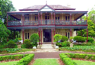
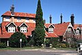
Boronia House is a heritage-listed former residence located at 624–632 Military Road, Mosman in the Mosman Council local government area of New South Wales, Australia. It was designed by Sheerin & Hennessy (1885) and Clive Lucas & Partners, and built during 1885. The property is owned by Mosman Council. The property is also called Boronia. It was added to the New South Wales State Heritage Register on 2 April 1999.

References

  1. 1 2 3 4 Australian Bureau of Statistics (27 June 2017). "Mosman (State Suburb)". 2016 Census QuickStats. Retrieved 11 October 2017. OOjs UI icon edit-ltr-progressive.svg
  2. Mosman Municipal Council - Ordinary Meeting Agenda - Meeting Date: 29 November 2005 Archived 19 September 2009 at the Wayback Machine pg 83.
  3. The Book of Sydney Suburbs, Compiled by Frances Pollen, Angus & Robertson Publishers, 1990, Published in Australia ISBN   0-207-14495-8, page 181
  4. 1 2 3 "A brief history of Mosman". Mosman Municipal Council. Archived from the original on 16 July 2014. Retrieved 1 August 2007.
  5. Moorehead, David; Cummins, Anne (2001). "Georges Head 'Beehive' Fortification, Sydney Harbour Structure and Materials Investigations". Eleventh National Conference on Engineering Heritage: Federation Engineering a Nation; Proceedings: 63–70.
  6. 1 2 Sydney Harbour Federation Trust Sites - Headland Park Archived 7 November 2007 at the Wayback Machine
  7. Army - The Soldiers' Newspaper
  8. Robin Tranter, Artists' camps, Dictionary of Sydney, 2008. Retrieved 9 May 2011
  9. John Huxley, Back to the wellspring of inspiration, Sydney Morning Herald , 7 December 2005. Retrieved 14 January 2010
  10. Gill, George Hermon (1968). Royal Australian Navy, 1942–1945, p 65
  11. Stevens, David (2005). A Critical Vulnerability, p 193
  12. Prescott, A.M. (1984). Sydney Ferry Fleets. Magill, South Australia: Ronald H. Parsons. ISBN   0-909418-30-6.
  13. "Hindsight". Mosman Magazine. December 2009. pp. 26–27.
  14. Andrews, Graeme (1982). The Pictorial History of Sydney Ferries. Sydney: AH & AW Reed. p. 19. ISBN   0-589-50386-3..
  15. Pollen, Frances (1990). The Book of Sydney Suburbs. Australia: Angus & Robertson. p. 180. ISBN   0-207-14495-8.
  16. Sydney and Blue Mountains Bushwalks, Neil Paton (Kangaroo Press) 2004, pp. 123–128
  17. "Isle of Ulva – connection with Scotland Australia Cairn".
  18. "Mosman Bay Sewage Aqueduct". New South Wales State Heritage Register . Department of Planning & Environment. H01328. Retrieved 18 May 2018. CC BY icon.svg Text is licensed by State of New South Wales (Department of Planning and Environment) under CC-BY 4.0 licence .
  19. 1 2 "Monterey, residential apartments". New South Wales State Heritage Register . Department of Planning & Environment. H00367. Retrieved 18 May 2018. CC BY icon.svg Text is licensed by State of New South Wales (Department of Planning and Environment) under CC-BY 4.0 licence .
  20. "The Barn - Scout Hall". New South Wales State Heritage Register . Department of Planning & Environment. H00188. Retrieved 18 May 2018. CC BY icon.svg Text is licensed by State of New South Wales (Department of Planning and Environment) under CC-BY 4.0 licence .
  21. "Alma House". New South Wales State Heritage Register . Department of Planning & Environment. H00070. Retrieved 18 May 2018. CC BY icon.svg Text is licensed by State of New South Wales (Department of Planning and Environment) under CC-BY 4.0 licence .
  22. "Bradleys Head Forts and HMAS Sydney 1 Mast and Associated Memorials". New South Wales State Heritage Register . Department of Planning & Environment. H01838. Retrieved 18 May 2018. CC BY icon.svg Text is licensed by State of New South Wales (Department of Planning and Environment) under CC-BY 4.0 licence .
  23. "Woolley House". New South Wales State Heritage Register . Department of Planning & Environment. H01514. Retrieved 18 May 2018. CC BY icon.svg Text is licensed by State of New South Wales (Department of Planning and Environment) under CC-BY 4.0 licence .
  24. "Building". New South Wales State Heritage Register . Department of Planning & Environment. H00430. Retrieved 18 May 2018. CC BY icon.svg Text is licensed by State of New South Wales (Department of Planning and Environment) under CC-BY 4.0 licence .
  25. 1 2 "Boronia". New South Wales State Heritage Register . Department of Planning & Environment. H00069. Retrieved 18 May 2018. CC BY icon.svg Text is licensed by State of New South Wales (Department of Planning and Environment) under CC-BY 4.0 licence .
  26. "Residence". New South Wales State Heritage Register . Department of Planning & Environment. H00210. Retrieved 18 May 2018. CC BY icon.svg Text is licensed by State of New South Wales (Department of Planning and Environment) under CC-BY 4.0 licence .
  27. "Igloo House, The". New South Wales State Heritage Register . Department of Planning & Environment. H01652. Retrieved 18 May 2018. CC BY icon.svg Text is licensed by State of New South Wales (Department of Planning and Environment) under CC-BY 4.0 licence .
  28. "Mosman Council: A brief history of Mosman". Archived from the original on 16 July 2014. Retrieved 11 July 2007.
  29. "Boronia House". New South Wales Heritage Database. Office of Environment & Heritage . Retrieved 10 August 2018.
  30. "Advertising". The Sydney Morning Herald . National Library of Australia. 4 October 1905. p. 12. Retrieved 23 October 2015.
  31. http://cdn.cityofsydney.nsw.gov.au/learn/history/archives/sands/1900-1909/1906-part4.pdf p421
  32. "Monterey". New South Wales Heritage Database. Office of Environment & Heritage . Retrieved 10 August 2018.
  33. The Theosophist, magazine (Theosophical Society) August 1997, pp. 460–463
  34. Lutyens, Mary (1959). To Be Young. Corgi Books. p. 153.
  35. "Avenue Cottage". New South Wales Heritage Database. Office of Environment & Heritage . Retrieved 10 August 2018.
  36. "Mosman NSW 2088, Suburb Profile & Property Market Trends | Domain". www.domain.com.au. Retrieved 5 June 2020.
  37. http://www.realestate.com.au/neighbourhoods/mosman-2088-nsw
  38. 1 2 Fraser, H.; Joyce, R. (1986). The Federation House, Australia's Own Style. Sydney: Lansdowne. pp. 13 and 115. ISBN   1-86302-126-4.
  39. State Heritage Website
  40. Wade, Matt (3 January 2014). "Australia's richest suburb: they're swimming in it". The Sydney Morning Herald. Retrieved 5 June 2020.
  41. Mosman High School–Website, retrieved 9 August 2010

33°49′45″S151°14′39″E / 33.829075°S 151.244090°E / -33.829075; 151.244090