Wiley Park, New South Wales

Last updated

Wiley Park
Sydney,  New South Wales
WileyPark2.jpg
King Georges Road, Wiley Park
Wiley Park, New South Wales
Population10,126 (2016 census) [1]
Postcode(s) 2195
Elevation43 m (141 ft)
Location17 km (11 mi) south-west of Sydney CBD
LGA(s) City of Canterbury-Bankstown
State electorate(s) Lakemba
Federal division(s) Watson
Suburbs around Wiley Park:
Punchbowl Punchbowl Lakemba
Punchbowl Wiley Park Lakemba
Roselands Roselands Roselands

Wiley Park is a suburb in south-western Sydney, in the state of New South Wales, Australia. Wiley Park is located 17 kilometres south-west of the Sydney central business district in the City of Canterbury-Bankstown.

Contents

History

The 20 acres (81,000 m2) now comprising Wiley Park was initially part of 60 acres (240,000 m2) of land granted to Robert Wilkinson in 1832. It passed to the Wiley family in 1862. [2]

Wiley Park is named after the reserve of 20 acres (81,000 m2) that was bequeathed in the will of Mr. J.V. Wiley in 1906 for a park and recreational ground for local residents. Wiley was a shoemaker who died unmarried and without children.

At the time the bequest caused some dissent with the local council but after much debate at a public meeting it was decided to accept the bequest. This park is bounded by King Georges Road, Canterbury Road, Clio Street and Edge Street. [3]

Commercial area

Cao Dai Temple, King Georges Road, Wiley Park WileyPark1.JPG
Cao Dai Temple, King Georges Road, Wiley Park

A small shopping strip is located on King Georges Road, near the Wiley Park railway station. The adjoining suburbs have a greater degree of commercial activity. The suburb is also close to the large Roselands Shopping Centre. Also on King Georges Road, south of the train station is the Cao Dai Temple.

Schools

Wiley Park Public School (formerly the Years 3-6 part of Lakemba Public School until 1984) and Lakemba Public School are located on opposite sides of King Georges Road.

Lakemba Public School was established on its present site around 1913. It has an "opportunity class" for Years 5 and 6 students in the region was located at the school for many years.

Lakemba Public School notable alumni includes Vin Wallace QC, who was a Crown Prosecutor in New South Wales from 1954 retiring as Senior Crown Prosecutor for New South Wales in 1978

Wiley Park Girls High School (established 1957) is also located here. Former NSW Ombudsman Irene Moss and chef Maggie Beer attended the school.

Transport

Wiley Park Station, King Georges Road WileyParkStation3.JPG
Wiley Park Station, King Georges Road

Wiley Park railway station is on the Bankstown Line of the Sydney Trains network.

King Georges Road is a main road running through Wiley Park that starts as Wiley Avenue, to the north in Greenacre through to Beverly Hills in the south and beyond. Canterbury Road runs along the southern border of the suburb.

Parks and culture

Wiley Park, King Georges road,

Wiley Park - ponds Wiley Park - ponds.jpg
Wiley Park - ponds

Wiley Park, on the corner of King Georges and Canterbury roads currently has a recreational area over 2.5 km2. It has a large pond, and houses the Wiley Park Bicentennial Amphitheatre where local events such as Carols in the Park at Christmas and Youth X Festival are held.

Until the 1980s, Wiley Park included a large velodrome that held events including Australian Championships and hosted concerts by a range of artists including Johnny O'Keefe. Cycling in the area was a popular sport, and a famous cycling store was operated by Jack Walsh in the adjoining suburb of Punchbowl for 50 years. Unfortunately the council allowed the velodrome to fall into disrepair and removed it without community consultation, replacing part of its area with an amphitheatre. Some sources cite that the loss of the velodrome was due to road widening. [4]

The amphitheater and its inside meeting room is now the home of Horizon Theatre Company.

Demographics

Wiley Park was formerly inhabited largely by Anglo Celtic residents of a working-class background. The suburb was to become an increasingly multicultural suburb from the late 1970s onwards, with many residents born overseas or having parents born overseas, from countries such as Lebanon, Vietnam, Italy, Greece, the Philippines and the Pacific Islands. At the 2011 census, 10% of the population was born in Bangladesh and 7.7% in Lebanon. The most common responses for religion in Wiley Park were Islam 44.0%, Catholic 15.0%, No Religion 6.3%, Eastern Orthodox 6.1% and Buddhism 6.0%. [1]

See also

Related Research Articles

<span class="mw-page-title-main">Beverly Hills, New South Wales</span> Suburb of Sydney, New South Wales, Australia

Beverly Hills is a southern suburb of Sydney, in the state of New South Wales, Australia. Beverly Hills is located 15 kilometres southwest of the Sydney central business district and is part of the St George area and is split between the local government areas of the Georges River Council and the City of Canterbury-Bankstown. The postcode is 2209, which it shares with neighbouring Narwee.

<span class="mw-page-title-main">Georges Hall</span> Suburb of Sydney, New South Wales, Australia

Georges Hall, a suburb of local government area City of Canterbury-Bankstown, is located 24 kilometres south-west of the Sydney central business district in the state of New South Wales, Australia, and is part of the South-western Sydney region.

<span class="mw-page-title-main">Bankstown</span> Suburb of Sydney, New South Wales, Australia

Bankstown is a suburb south west of Sydney, in the state of New South Wales, Australia. It is 19 kilometres south-west of the Sydney central business district and is located in the local government area of the City of Canterbury-Bankstown, having previously been the administrative centre of the City of Bankstown prior to 2016. It is the most populous suburb within the City of Canterbury-Bankstown.

<span class="mw-page-title-main">Lakemba, New South Wales</span> Suburb of City of Canterbury-Bankstown, New South Wales, Australia

Lakemba is a suburb south west of Sydney, in the state of New South Wales, Australia. Lakemba is located 12 kilometres south west of the Sydney central business district, in the local government area of the City of Canterbury-Bankstown.

<span class="mw-page-title-main">Padstow, New South Wales</span> Suburb of City of Canterbury-Bankstown, New South Wales, Australia

Padstow, a suburb of local government area City of Canterbury-Bankstown, is located 21 kilometres south-west of the Sydney central business district, in the state of New South Wales, Australia, and is a part of the South-western Sydney region. It is westernmost suburb in the St George area, and the easternmost suburb in Greater Western Sydney, bordering the Southern Sydney region to the east.

<span class="mw-page-title-main">Canterbury, New South Wales</span> Suburb of Sydney, New South Wales, Australia

Canterbury is a suburb of south-western Sydney, in the state of New South Wales, Australia. Canterbury is located 10.5 kilometres (6.5 mi) south-west of the Sydney central business district in the City of Canterbury-Bankstown.

<span class="mw-page-title-main">Bass Hill</span> Suburb of Sydney, New South Wales, Australia

Bass Hill, a suburb of local government area City of Canterbury-Bankstown, is located 23 kilometres south-west of the Sydney central business district, in the state of New South Wales, Australia, and is a part of the South-western Sydney region.

<span class="mw-page-title-main">Roselands, New South Wales</span> Suburb of Sydney, New South Wales, Australia

Roselands is a suburb to the south-west of the Sydney CBD, in the state of New South Wales, Australia. Roselands is located 16 kilometres south-west of the Sydney central business district in the City of Canterbury-Bankstown. It is one of the easternmost suburbs in the Western Sydney area and is one of the major suburbs in Sydney without a train station.

Picnic Point, a suburb of local government area City of Canterbury-Bankstown, is 23 kilometres south-west of the Sydney central business district, in the state of New South Wales, Australia. It is a part of South-western Sydney region. Picnic Point is a residential suburb on the northern bank of the Georges River. Located within Picnic Point is Yeramba Lagoon which is the largest tract of National Park within the Canterbury – Bankstown Council, it is home to numerous species of native fauna and flora.

<span class="mw-page-title-main">Narwee, New South Wales</span> Suburb of Sydney, New South Wales, Australia

Narwee is a suburb in southern Sydney, in the state of New South Wales, Australia. Narwee is located 18 kilometres south of the Sydney central business district and is part of the St George area. Narwee is in local government areas of City of Canterbury-Bankstown and Georges River Council. The postcode is 2209, which it shares with neighbouring Beverly Hills.

<span class="mw-page-title-main">Kingsgrove</span> Suburb of Sydney, New South Wales, Australia

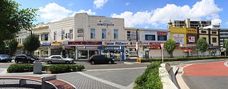
Kingsgrove is a suburb in Southern Sydney, New South Wales, Australia. Kingsgrove is 13 kilometres (8.1 mi) south-west of the Sydney central business district and lies across the local government areas of the City of Canterbury-Bankstown, Bayside Council and the Georges River Council.

<span class="mw-page-title-main">Chester Hill</span> City in New South Wales, Australia

Chester Hill, a suburb of the City of Canterbury-Bankstown local government area, is located 25 kilometres west of the Sydney central business district, in the state of New South Wales, Australia, and is part of Western Sydney, Chester Hill shares the postcode of 2162 with the neighbouring suburb of Sefton.

<span class="mw-page-title-main">Condell Park</span> Suburb of Sydney, New South Wales, Australia

Condell Park, a suburb of local government area City of Canterbury-Bankstown, is 21 kilometres south-west of the Sydney central business district, in the state of New South Wales, Australia, and is a part of the south-western Sydney region. The postcode of Condell Park is 2200, which is shared with Bankstown and Bankstown Aerodrome.

<span class="mw-page-title-main">East Hills, New South Wales</span> Suburb of Sydney, New South Wales, Australia

East Hills, a suburb of local government area City of Canterbury-Bankstown, is located 26 kilometres south-west of the Sydney central business district, in the state of New South Wales, Australia, and is a part of the South-western Sydney region, near larger areas like Liverpool, Revesby, and Bankstown.

<span class="mw-page-title-main">Greenacre, New South Wales</span> Suburb of Sydney, New South Wales, Australia

Greenacre is suburb in South-western Sydney, located 20 kilometres south-west of the Sydney central business district in the state of New South Wales, Australia. Most of Greenacre is in the local government area of the City of Canterbury-Bankstown, while a part in the east is in the Municipality of Strathfield.

<span class="mw-page-title-main">Campsie, New South Wales</span> Suburb of Sydney, New South Wales, Australia

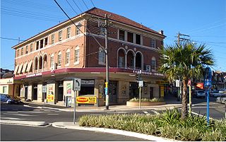
Campsie is a suburb in the state of New South Wales, Australia. Campsie is 11 kilometres south west of the Sydney central business district, on the southern bank of the Cooks River. Campsie is one of the administrative centres of the City of Canterbury-Bankstown.

<span class="mw-page-title-main">Earlwood, New South Wales</span> Suburb of Sydney, New South Wales, Australia

Earlwood is a suburb of Sydney, in the state of New South Wales, Australia. Earlwood is located 10 kilometres south-west of the Sydney central business district, and is part of the Canterbury-Bankstown area. It is in the local government area of the City of Canterbury-Bankstown.

<span class="mw-page-title-main">Belfield, New South Wales</span> Suburb of Sydney, New South Wales, Australia

Belfield is a suburb of Sydney, in the state of New South Wales, Australia. It is 8 miles (13 km) southwest of the Sydney central business district, in the local government area of the City of Canterbury-Bankstown and partly in the Municipality of Strathfield.

<span class="mw-page-title-main">Belmore, New South Wales</span> Suburb of Sydney, New South Wales, Australia

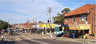
Belmore is a suburb of Sydney, in the state of New South Wales, Australia. Belmore is located 11 kilometres south-west of the Sydney central business district, in the local government area of the City of Canterbury-Bankstown.

<span class="mw-page-title-main">Clemton Park, New South Wales</span> Suburb of Sydney, New South Wales, Australia

Clemton Park is a suburb in south-western Sydney, in the state of New South Wales, Australia. It is 13 kilometres south-west of the Sydney central business district in the City of Canterbury-Bankstown. The suburb is approximately bounded by Cup and Saucer Creek, Bexley Road in the east, William Street in the south and Kingsgrove Road, but excludes most of the properties which face onto those roads. Those properties are instead in the neighbouring suburbs of Earlwood, Kingsgrove and Campsie.

References

  1. 1 2 Australian Bureau of Statistics (27 June 2017). "Wiley Park (State Suburb)". 2016 Census QuickStats. Retrieved 11 April 2018. OOjs UI icon edit-ltr-progressive.svg
  2. "Wiley Park | The Dictionary of Sydney". dictionaryofsydney.org. Retrieved 3 September 2022.
  3. The Book of Sydney Suburbs, Compiled by Frances Pollon, Angus & Robertson Publishers, 1990, Published in Australia ISBN   0-207-14495-8, page 271
  4. GTVeloce.com

Coordinates: 33°55′33″S151°3′48″E / 33.92583°S 151.06333°E / -33.92583; 151.06333