Belfield, New South Wales

Last updated

Belfield
Sydney,  New South Wales
Belfield Hotel.JPG
Belfield Hotel
Belfield, New South Wales
Map
Population6,322 (2016 census) [1]
Postcode(s) 2191
Elevation27 m (89 ft)
Location12.3 km (8 mi) west of Sydney CBD
LGA(s) City of Canterbury-Bankstown
State electorate(s)
Federal division(s) Watson
Suburbs around Belfield:
Strathfield South Strathfield South Enfield
Greenacre Belfield Croydon Park
Lakemba Belmore Campsie

Belfield is a suburb of Sydney, in the state of New South Wales, Australia. It is 13 kilometres (8 miles) southwest of the Sydney central business district, in the local government area of the City of Canterbury-Bankstown.\

Contents

History

Land grants were made as early as 1810 for agricultural purposes, on the northern side of Punchbowl Road (towards Strathfield).[ citation needed ] The "Punch Bowl" was the name that early settlers gave the almost circular valley where the old road to Georges River crossed Cooks River at a ford.[ citation needed ] This is now where Georges River Road meets Punchbowl Road (the road to "The Punch Bowl") in Belfield.

The name of the suburb is believed to have been created by combining the names of the two neighbouring suburbs, Belmore and Enfield. From information supplied by the Postmaster General's Department, the name "Belfield" first appeared on their records in 1930 when the Belfield branch of the ALP wrote asking that the Department establish a post office at North Belmore. Although several applications were made over the years, it was not until 1936 that the postal inspector reported in favor of a non-official post office. His report read: "...There is a business centre here consisting of sixteen shops, one garage and one Hotel. It is a prosperous business section. This part of the locality is approximately midway between Belmore and Enfield. It is known as Belfield"... - the name derived from its position between the two suburbs mentioned, Belmore and Enfield. [2]

The Department of Lands advised that it had no objection to the use of the name "Belfield" and approval was subsequently given for the establishment of a non-official post office.[ citation needed ] In 1921, Belfield was the site of one of the first war services home developments in Australia, providing housing for World War I servicemen. The part of Belfield north of Punchbowl Road was in Enfield Council, but was transferred to Strathfield Council in 1949 together with the west ward of Enfield Council.[ citation needed ]

The place name of "Belfield" was first gazetted in 1977. The official boundaries for Belfield were re-gazetted during August 1993 together with all other suburbs in the Canterbury Local Government Area, and again in 1995. [3]

Three streets are named after World War I sites of importance to Australians; Bazentin Street (after the town Bazentin in the Somme, France, site of the Battle of Bazentin Ridge in July 1916), Persic Street (after the SS Persic, a ship that transported Australian soldiers to Europe during the war) and Mena Street (after Mena Camp, Egypt, an AIF training base prior to the Gallipoli Campaign). A fourth street, Birdwood Avenue, is named after General William Birdwood, the ANZAC commander in Gallipoli. [4]

The majority of houses in Belfield were built after World War II, as public housing. Many of the houses have been turned over to private ownership since then. Australia's first Pizza Hut opened in Belfield in April 1970, but closed in 1998.[ citation needed ]

In 2023, what was at that time the northern part of Belfield which was within the Municipality of Strathfield (north of Punchbowl Road and south of the Cooks River and Cox Creek) was separated from the southern part within the City of Canterbury-Bankstown and became part of Strathfield South, from which it was (until then) separated by the Cooks River. [5]


Location

Belfield has a mixture of residential, light industrial and commercial areas. A small shopping strip is located along Burwood Road. The northern boundary of Belfield is Punchbowl Road. A crescent-shaped area north of Punchbowl Road and south of the Cooks River and its tributary, Coxs Creek, is in Strathfield Council and was formerly also part of Belfield, but in 2023 was transferred to the suburb of Strathfield South.

Demographics

According to the 2016 census, there were 6,322 residents in Belfield. 56.6% of residents were born in Australia. The most common other countries of birth were China 5.3%, Lebanon 5.2%, South Korea 4.3%, Italy 3.3% and Greece 2.3%. The most common reported ancestries were Lebanese (14.5%), Australian (11.2%), Italian (11.0%), Chinese (9.4%) and English (9.3%).

42.4% of residents spoke only English at home. Other languages spoken at home included Arabic 13.6%, Korean 6%, Italian 6%, Greek 5.8% and Mandarin 5.4%. The most common responses for religious affiliation were Catholic 40.7%, No Religion 14.6% and Eastern Orthodox 9.7%. [1]

Schools and churches

Belfield has a number of houses of worship, and St. Michael's Primary School opened in 1959. There is also a Uniting Church on Punchbowl Road and a Korean Presbyterian Church (formally Church of England) on Burwood Road.

Sport

The Belfield Bowling and Recreation Club is a bowls club located near the intersection of Punchbowl Road and Georges River Road and the Cooks River. Rudd Park is home to the Belmore Eagles Soccer Club and features two tennis courts, and rugby league Enfield Federals home ground Cooke Park.

Commercial area

A small group of shops, restaurants, post office and a hotel are located on Burwood Road, near the intersection of Punchbowl Road. The Belfield area is being renovated with new shops and apartments. It also includes a pizza bar, a bakery and a cafe.

Related Research Articles

<span class="mw-page-title-main">Municipality of Strathfield</span> Local government area in New South Wales, Australia

The Municipality of Strathfield is a local government area in the Inner West of Sydney, in the state of New South Wales, Australia.

<span class="mw-page-title-main">Inner West</span> Region in New South Wales, Australia

The Inner West of Sydney is an area directly west of the Sydney central business district, New South Wales, Australia. The suburbs that make up the Inner West are predominantly located along the southern shore of Port Jackson, stretching south to the shores of the Cooks River. The western boundary of the Inner West is approximately the A3 arterial road, which divides the Inner West from the Greater Western Sydney region. The Inner West is much larger than the Inner West Council local government area. The Inner West roughly corresponds with the Parish of Petersham and Parish of Concord, two cadastral divisions used for land titles.

<span class="mw-page-title-main">Lakemba, New South Wales</span> Suburb of City of Canterbury-Bankstown, New South Wales, Australia

Lakemba is a suburb in Western Sydney, in the state of New South Wales, Australia. Lakemba is located 12 kilometres south west of the Sydney central business district, in the local government area of the City of Canterbury-Bankstown.

Riverwood is a suburb in southern Sydney, in the state of New South Wales, Australia. Riverwood is located 19 kilometres south of the Sydney central business district and is part of the St George area. Riverwood is split between the local government areas of the Georges River Council and the City of Canterbury-Bankstown.

<span class="mw-page-title-main">Bankstown railway station</span> Railway station in Sydney, New South Wales

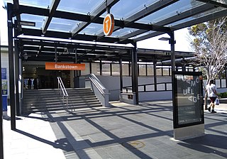
Bankstown railway station is located on the Bankstown line, serving the Sydney suburb of Bankstown. It is served by Sydney Trains T3 Bankstown line services.

<span class="mw-page-title-main">Division of Watson</span> Australian federal electoral division

The Division of Watson is an Australian electoral division in the state of New South Wales.

<span class="mw-page-title-main">Belmore railway station</span> Railway station in Sydney, New South Wales, Australia

Belmore railway station is a heritage-listed railway station located on the Bankstown line at Burwood Road, Belmore in the City of Canterbury-Bankstown local government area of New South Wales, Australia. It is served by Sydney Trains T3 Bankstown line services. It was designed and built by NSW Government Railways from 1895 to 1937. It is also known as Belmore Railway Station Group and Burwood Road. The property was added to the New South Wales State Heritage Register on 2 April 1999.

<span class="mw-page-title-main">Strathfield South, New South Wales</span> Suburb of Sydney, New South Wales, Australia

Strathfield South is a suburb, in the Inner West of Sydney, Australia in the state of New South Wales, 13 kilometres west of the Sydney central business district, in the Strathfield local government area. The area was historically part of Druitt Town. Later it was part of Enfield, until Enfield Council was absorbed into Strathfield and Burwood councils, after which the part within Strathfield council was renamed Strathfield South.

<span class="mw-page-title-main">Roselands, New South Wales</span> Suburb of Sydney, New South Wales, Australia

Roselands is a suburb to the south-west of the Sydney CBD, in the state of New South Wales, Australia. Roselands is located 16 kilometres south-west of the Sydney central business district in the City of Canterbury-Bankstown. It is one of the easternmost suburbs in the Western Sydney area and is one of the major suburbs in Sydney without a train station.

<span class="mw-page-title-main">Punchbowl, New South Wales</span> Suburb of City of Canterbury-Bankstown, New South Wales, Australia

Punchbowl is a suburb in the south west of Sydney, 17 kilometres (11 mi) west of the Sydney central business district, in the local government area of the City of Canterbury-Bankstown, in the state of New South Wales, Australia. At the 2016 census, Punchbowl had a population of 20,236.

<span class="mw-page-title-main">Greenacre, New South Wales</span> Suburb of Sydney, New South Wales, Australia

Greenacre is a suburb in South-western Sydney, located 20 kilometres south-west of the Sydney central business district in the state of New South Wales, Australia. Most of Greenacre is in the local government area of the City of Canterbury-Bankstown, while a part in the east is in the Municipality of Strathfield.

<span class="mw-page-title-main">Campsie, New South Wales</span> Suburb of Sydney, New South Wales, Australia

Campsie is a suburb in the state of New South Wales, Australia. Campsie is 11 kilometres south west of the Sydney central business district, on the southern bank of the Cooks River. Campsie is one of the administrative centres of the City of Canterbury-Bankstown.

<span class="mw-page-title-main">Belmore, New South Wales</span> Suburb of Sydney, New South Wales, Australia

Belmore is a suburb of Sydney, in the state of New South Wales, Australia. Belmore is located 11 kilometres south-west of the Sydney central business district, in the local government area of the City of Canterbury-Bankstown.

<span class="mw-page-title-main">Croydon Park, New South Wales</span> Suburb of Sydney, New South Wales, Australia

Croydon Park is a suburb in the Inner West of Sydney, in the state of New South Wales, Australia. Croydon Park is 10 kilometres south-west of the Sydney central business district and is divided between the local government areas of the City of Canterbury-Bankstown, Municipality of Burwood and Inner West Council. Croydon is a separate suburb, to the north.

<span class="mw-page-title-main">Enfield, New South Wales</span> Suburb of Sydney, New South Wales, Australia

Enfield is a suburb in the Inner West of Sydney, in the state of New South Wales, Australia. It is 11 kilometres south-west of the Sydney central business district in the local government area of Municipality of Burwood.

<span class="mw-page-title-main">Punchbowl Bus Company</span>

Punchbowl Bus Company (PBC) is an Australian bus company. It operates bus services in Goulburn and Crookwell in the Southern Tablelands as PBC Goulburn and PBC Crookwell.

<span class="mw-page-title-main">Canterbury-Bankstown</span> Region in New South Wales, Australia

Canterbury-Bankstown is a customary region of Sydney, Australia, in the south-western suburbs. The area is located to the north of the St George region and to the south of the Inner West region. The Bankstown railway line serves many of the suburbs in this region. The suburbs of the Canterbury-Bankstown region are not specific to the local government area of the City of Canterbury-Bankstown, but includes many of them. The region lies on the eastern reaches of the Cumberland Plain.

<span class="mw-page-title-main">Canterbury District Soccer Football Association</span>

Canterbury District Soccer Football Association is a governing body and football (soccer) competition located in the Canterbury suburbs of Sydney. Its administrative headquarters are located at Pratten Park Bowls, Ashfield, New South Wales. All competitions and football activity is under control of Football New South Wales. The District Association consists of ten all ages competitions which corresponds to tiers six to fifteen on the Australian soccer pyramid. Clubs are located in the Burwood, Canada Bay, Canterbury-Bankstown, Inner West and Strathfield local council areas.

Highway Tours was an Australian bus company operating services in the south-western suburbs of Sydney, New South Wales.

<span class="mw-page-title-main">City of Canterbury-Bankstown</span> Local government area in New South Wales, Australia

Canterbury-Bankstown Council, trading as the City of Canterbury Bankstown, is a local government area located in the South Western region of Sydney, New South Wales, Australia. The council was formed on 12 May 2016 from a merger of the City of Canterbury and the City of Bankstown, after a review of local government in New South Wales by the state government. The eastern portion of the council that was once City of Canterbury falls within the northern portion of The Parish of St George above Wolli Creek and The M5 but below the Cooks River.

References

  1. 1 2 Australian Bureau of Statistics (27 June 2017). "Belfield (State Suburb)". 2016 Census QuickStats. Retrieved 25 January 2018. OOjs UI icon edit-ltr-progressive.svg
  2. Book of Sydney Suburbs, Frances Pollon (Angus and Robertson) 1990, p. 25
  3. Geographical Names Board - "Belfield"
  4. Book of Sydney Suburbs, p. 25
  5. Geographical Names Board - Media Release - Belfield, 4 August 2021

33°54′18″S151°5′2″E / 33.90500°S 151.08389°E / -33.90500; 151.08389