Beverly Hills, New South Wales

Last updated

Beverly Hills
Sydney,  New South Wales
Kingsgrove Rd, Beverly Hills 02.jpg
King Georges Road looking south
Beverly Hills, New South Wales
Map
Population10,156 (2016 census) [1]
Postcode(s) 2209
Elevation32 m (105 ft)
Location15 km (9 mi) south-west of Sydney CBD
LGA(s)
State electorate(s)
Federal division(s)
Suburbs around Beverly Hills:
Riverwood Narwee Roselands
Peakhurst Beverly Hills Kingsgrove
Mortdale Penshurst Hurstville

Beverly Hills is a southern suburb of Sydney, in the state of New South Wales, Australia. Beverly Hills is located 15 kilometres southwest of the Sydney central business district and is part of the St George area and is split between the local government areas of the Georges River Council and the City of Canterbury-Bankstown. The postcode is 2209, which it shares with neighbouring Narwee.

Contents

Beverly Hills is mostly residential, consisting of many freestanding red brick and tile bungalows built in the years immediately after World War II. Many of these feature late Art Deco design elements. Medium density flats have been built in the areas close to King Georges Road and Stoney Creek Road.

History

Beverly Hills Hotel, King Georges Road Beverly Hills Hotel Sydney.JPG
Beverly Hills Hotel, King Georges Road

Beverly Hills was originally known as Dumbleton after a local farm in the area, circa 1830. This name was generally disliked by residents who lobbied to supplant it with a more glamorous alternative to coincide with the arrival of the East Hills railway line, which opened 31 December 1931. The name was changed to Beverly Hills, at a time when Beverly Hills in California was becoming known for being the home of many famous movie stars. Real estate developments followed in the 1930s and 1940s. The post office opened 1 October 1940. [2]

Heritage listings

Beverly Hills has a number of heritage-listed sites, including:

Commercial area

King Georges Road King Georges Road, Beverly Hills.jpg
King Georges Road

The main shopping strip is located on King Georges Road, near the Beverly Hills railway station. There are over 40 different cafes, restaurants and takeaways along King Georges Road featuring Asian, Mediterranean, and Modern Australian cuisines.

The area has all the features typical of Australian metropolitan localities: restaurants, retail shops, an IGA supermarket, real estate agents, a pub (the Beverly Hills Hotel), cinema, ATMs, kindergarten, primary/high schools, Scouts, parks, leisure and health facilities.

Transport

Beverly Hills railway station is on the Airport & South Line of the Sydney Trains network.

The main road running through Beverly Hills is King Georges Road, connecting it north to Wiley Park and south to Blakehurst. The road has palm trees running through its median strip as a nod to its Californian namesake. The other main road in Beverly Hills is Stoney Creek Road. This road intersects King Georges Road and connects Beverly Hills west to Peakhurst and onto Menai, and east to Rockdale, Brighton-Le-Sands, Mascot and Sydney Airport.

Entrances to the M5 Motorway are located on King Georges Road, north of the shopping centre. The M5 Motorway connects east to Bexley North, Arncliffe, Sydney Airport and the Sydney CBD and west to Liverpool and Campbelltown. Buses run along King Georges Rd connecting travellers to commercial and shopping centres at Hurstville and Roselands.

Schools

Notable amongst the public buildings and amenities are Beverly Hills Girls' High School, Beverly Hills Primary School, Beverly Hills North Primary School and Regina Coeli Primary Schoo. Beverly Hills Girls' High School has approximately 1100 students and in September 2010 was named a Centre for Excellence by NSW DET. [8]

Churches

Regina Coeli Catholic Church Beverly Hills Church.JPG
Regina Coeli Catholic Church

Regina Coeli Roman Catholic Church is Australia's only Catholic war memorial church. It was built in the early 1960s to commemorate the Australian-US alliance during World War II. The flags of both nations are permanently hung on either side of the main altar, and a special Mass attended by US service personnel and diplomatic representatives is conducted there annually in commemoration of the Battle of the Coral Sea. Regina Coeli is sited prominently on the highest point in Beverly Hills, and is a landmark visible for many kilometres in all directions.

Other churches in the suburb include: St Matthews Anglican Church, St Bede's Anglican Church, Church@School, Beverly Hills Baptist Church, Beverly Hills Chinese Baptist Church, Beverly Hills Church of Christ, and Beverly Hills New Apostolic Church.

Parks and recreation

Demographics

According to the 2016 census of Population, there were 10,156 residents in Beverly Hills. 49.4% of people were born in Australia. The most common countries of birth were China 14.7%, Hong Kong 3.3%, Greece 2.4%, Vietnam 2.2% and New Zealand 1.8%. 37.3% of people only spoke English at home. Other languages spoken at home included Cantonese 14.3%, Mandarin 12.4%, Greek 8.2%, Arabic 5.6% and Vietnamese 2.3%. The next most common responses for religious affiliation were No Religion 24.3%, Catholic 23.2% and Eastern Orthodox 12.3%. [1]

Notable residents

Related Research Articles

<span class="mw-page-title-main">Parramatta</span> City in New South Wales, Australia

Parramatta is a major CBD and a suburb in Greater Western Sydney, located in New South Wales, Australia. It is located approximately 24 kilometres (15 mi) west of Central Sydney, on the banks of the Parramatta River. Parramatta is the administrative seat of the local government area of the City of Parramatta and is often regarded as one of the city centres of the Greater Sydney Metropolitan area, alongside with Sydney, Penrith, Liverpool, etc. Parramatta also has a long history as a second administrative centre in the Sydney metropolitan region, playing host to a number of state government departments as well as state and federal courts. It is often colloquially referred to as "Parra".

<span class="mw-page-title-main">Castle Hill, New South Wales</span> Suburb of Greater Western Sydney, New South Wales, Australia

Castle Hill is a suburb of Sydney, New South Wales, Australia, located 34 kilometres north-west of the Sydney central business district and 9.5 kilometres north of Parramatta. It is within the Hills District region, split between the local government areas of The Hills Shire and Hornsby Shire.

<span class="mw-page-title-main">Mascot, New South Wales</span> Suburb of Sydney, New South Wales, Australia

Mascot is a suburb in the Inner-South of Sydney, in the state of New South Wales, Australia. Mascot is located 7 kilometres south of the Sydney central business district and is one of the administrative centres of the Bayside Council. A small part of Mascot is located in the Inner West Council. Mascot is on the north-west side of Botany Bay and contains Sydney Airport.

<span class="mw-page-title-main">Hurstville, New South Wales</span> Suburb of Sydney, New South Wales, Australia

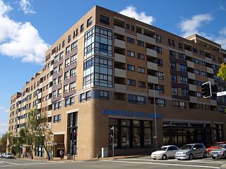
Hurstville is a suburb in Southern Sydney, New South Wales, Australia. It is 16 kilometres south of the Sydney CBD and is part of the St George area. Hurstville is the administrative centre of the local government area of the Georges River Council.

<span class="mw-page-title-main">Surry Hills, New South Wales</span> Suburb of Sydney, New South Wales, Australia

Surry Hills is an inner-east suburb of Sydney, in the state of New South Wales, Australia. Surry Hills is immediately south-east of the Sydney central business district in the local government area of the City of Sydney. Surry Hills is surrounded by the suburbs of Darlinghurst to the north, Chippendale and Haymarket to the west, Moore Park and Paddington to the east and Redfern to the south. It is often colloquially referred to as "Surry".

<span class="mw-page-title-main">Pymble, New South Wales</span> Suburb of Sydney, New South Wales, Australia

Pymble is a suburb on the Upper North Shore of Sydney in the state of New South Wales, Australia. Pymble is 15 kilometres (9 mi) north of the Sydney Central Business District in the local government area of Ku-ring-gai Council.

<span class="mw-page-title-main">Randwick, New South Wales</span> Suburb of Sydney, New South Wales, Australia

Randwick is a suburb in the Eastern Suburbs of Sydney, in the state of New South Wales, Australia. Randwick is located 6 kilometres south-east of the Sydney central business district and is the administrative centre for the local government area of the City of Randwick. The postcode is 2031.

<span class="mw-page-title-main">Eastwood, New South Wales</span> Suburb of Sydney, New South Wales, Australia

Eastwood is a suburb of Sydney, Australia. Eastwood is located 17 kilometres north-west of the Sydney central business district in the local government areas of the City of Ryde and the City of Parramatta. Eastwood is in the Northern Sydney region. The area is best known for being an ethnic enclave for immigrant populations in Sydney, mainly of East Asian origin but the suburb also has a significant number of other immigrant populations. Eastwood was originally its own town but due to the expansion of Sydney, was eventually absorbed.

<span class="mw-page-title-main">Rooty Hill, New South Wales</span> Suburb of Sydney, New South Wales, Australia

Rooty Hill is a suburb of Sydney, in the state of New South Wales, Australia. Rooty Hill is located 42 kilometres west of the Sydney central business district, in the local government area of the City of Blacktown and is part of the Greater Western Sydney region.

<span class="mw-page-title-main">Petersham, New South Wales</span> Suburb of Sydney, New South Wales, Australia

Petersham is a suburb in the Inner West of Sydney, in the state of New South Wales, Australia. Petersham is located 6 kilometres south-west of the Sydney central business district, in the local government area of Inner West Council. Petersham is known for its extensive Portuguese commercial offerings, with many Portuguese businesses and restaurants, although only 156 (1.9%) of the population was actually born in Portugal.

<span class="mw-page-title-main">Canterbury, New South Wales</span> Suburb of Sydney, New South Wales, Australia

Canterbury is a suburb of south-western Sydney, in the state of New South Wales, Australia. Canterbury is located 10.5 kilometres (6.5 mi) south-west of the Sydney central business district in the City of Canterbury-Bankstown.

<span class="mw-page-title-main">Erskineville</span> Suburb of Sydney, New South Wales, Australia

Erskineville is an inner-city suburb of Sydney, in the state of New South Wales, Australia. It is located 6 kilometres south west of the Sydney central business district and is part of the local government area of the City of Sydney. Erskineville is a diverse suburb homing to a wide variety of ethnicity from its varying Southeast Europe and Aboriginal community. Erskineville is colloquially known as Erko.

<span class="mw-page-title-main">Kellyville Ridge, New South Wales</span> Suburb of Sydney, New South Wales, Australia

Kellyville Ridge is a suburb of Sydney, in the state of New South Wales, Australia. Kellyville Ridge is located 41 kilometres north-west of the Sydney central business district in the local government area of City of Blacktown. It is part of Greater Western Sydney.

<span class="mw-page-title-main">Narwee, New South Wales</span> Suburb of Sydney, New South Wales, Australia

Narwee is a suburb in southern Sydney, in the state of New South Wales, Australia. Narwee is located 18 kilometres south of the Sydney central business district and is part of the St George area. Narwee is in local government areas of City of Canterbury-Bankstown and Georges River Council. The postcode is 2209, which it shares with neighbouring Beverly Hills.

<span class="mw-page-title-main">Kingsgrove</span> Suburb of Sydney, New South Wales, Australia

Kingsgrove is a suburb in Southern Sydney, New South Wales, Australia. Kingsgrove is 13 kilometres (8.1 mi) south-west of the Sydney central business district and lies across the local government areas of the City of Canterbury-Bankstown, Bayside Council and the Georges River Council.

<span class="mw-page-title-main">Croydon Park, New South Wales</span> Suburb of Sydney, New South Wales, Australia

Croydon Park is a suburb in the Inner West of Sydney, in the state of New South Wales, Australia. Croydon Park is 10 kilometres south-west of the Sydney central business district and is divided between the local government areas of the City of Canterbury-Bankstown, Municipality of Burwood and Inner West Council. Croydon is a separate suburb, to the north.

<span class="mw-page-title-main">Beverly Hills railway station</span> Railway station in Sydney, New South Wales, Australia

Beverly Hills railway station is a heritage-listed former railway bridge and now railway station located on the East Hills line, serving the Sydney suburb of Beverly Hills in the Georges River Council local government area of New South Wales, Australia. The station is served by Sydney Trains T8 Airport & South line services. The station was designed and built by the NSW Government Railways. It is also known as the Beverly Hills Railway Station group and Dumbleton Railway Station. The property was added to the New South Wales State Heritage Register on 2 April 1999.

Australian non-residential architectural styles are a set of Australian architectural styles that apply to buildings used for purposes other than residence and have been around only since the first colonial government buildings of early European settlement of Australia in 1788.

<span class="mw-page-title-main">City of Canterbury-Bankstown</span> Local government area in New South Wales, Australia

The City of Canterbury Bankstown is a local government area located in the South Western region of Sydney, New South Wales, Australia. The council was formed on 12 May 2016 from a merger of the City of Canterbury and the City of Bankstown, after a review of local government in New South Wales by the state government. The eastern portion of the council that was once City of Canterbury falls within the northern portion of The Parish of St George above Wolli Creek and The M5 but below The Cooks River.

References

  1. 1 2 Australian Bureau of Statistics (27 June 2017). "Beverly Hills (State Suburb)". 2016 Census QuickStats. Retrieved 11 April 2018. OOjs UI icon edit-ltr-progressive.svg
  2. The Book of Sydney Suburbs, Frances Pollon, Angus & Robertson Publishers, 1990, Published in Australia ISBN   0-207-14495-8, page 27
  3. "Beverly Hills Railway Station group". New South Wales State Heritage Register . Department of Planning & Environment. H01086. Retrieved 18 May 2018. CC BY icon.svg Text is licensed by State of New South Wales (Department of Planning and Environment) under CC-BY 4.0 licence .
  4. "Devonia Farm House | Heritage NSW". apps.environment.nsw.gov.au. Retrieved 21 July 2020.
  5. "Federation House | Heritage NSW". apps.environment.nsw.gov.au. Retrieved 21 July 2020.
  6. "Hilcrest | Heritage NSW". apps.environment.nsw.gov.au. Retrieved 21 July 2020.
  7. "Woodville | Heritage NSW". apps.environment.nsw.gov.au. Retrieved 21 July 2020.
  8. "Beverly Hills Girls High School". @NSWDepartmentofEducation. Retrieved 21 July 2020.
  9. 1 2 Australian Dictionary of Biography

33°57′5″S151°4′46″E / 33.95139°S 151.07944°E / -33.95139; 151.07944