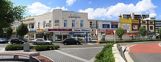
Beverly Hills is a southern suburb of Sydney, in the state of New South Wales, Australia. Beverly Hills is located 15 kilometres southwest of the Sydney central business district and is part of the St George area and is split between the local government areas of the Georges River Council and the City of Canterbury-Bankstown. It is often colloquially referred to as "Bevo". The postcode is 2209, which it shares with neighbouring Narwee.
Bankstown is a suburb south west of Sydney, in the state of New South Wales, Australia. It is 16 kilometres south-west of the Sydney central business district and is located in the local government area of the City of Canterbury-Bankstown, having previously been the administrative centre of the City of Bankstown prior to 2016. It is the most populous suburb within the City of Canterbury-Bankstown.

Hurlstone Park is a suburb in the Inner West of Sydney, New South Wales, Australia. Hurlstone Park is located nine kilometres south-west of the Sydney central business district and is mostly in the local government area of the City of Canterbury-Bankstown, and partly in the Inner West Council. The suburb is bounded by: the Cooks River to the south, Garnet Street to the east, New Canterbury Road to the north, Canterbury Road to the north-west, and Church Street to the west.

The Inner West of Sydney is an area directly west of the Sydney central business district, New South Wales, Australia. The suburbs that make up the Inner West are predominantly located along the southern shore of Port Jackson, stretching south to the shores of the Cooks River. The western boundary of the Inner West is approximately the A3 arterial road, which divides the Inner West from the Greater Western Sydney region. The Inner West is much larger than the Inner West Council local government area. The Inner West roughly corresponds with the Parish of Petersham and Parish of Concord, two cadastral divisions used for land titles.

Lakemba is a suburb south west of Sydney, in the state of New South Wales, Australia. Lakemba is located 12 kilometres south west of the Sydney central business district, in the local government area of the City of Canterbury-Bankstown. It is one of the easternmost suburbs in Greater Western Sydney.

Dulwich Hill is a suburb in the Inner West of Sydney, in the state of New South Wales, Australia. It is 7.5 kilometres south-west of the Sydney central business district, in the local government area of Inner West Council. Dulwich Hill stretches south to the shore of the Cooks River.

Burwood is a suburb in the Inner West of Sydney, in the state of New South Wales, Australia. It is 10 kilometres (6.2 mi) west of the Sydney central business district and is the administrative centre for the local government area of Municipality of Burwood. People from Burwood are colloquially known as Burwoodiens or Burwooders.

Canterbury is a suburb extending across south-western Sydney and the Inner West, in the state of New South Wales, Australia. Canterbury is located 10.5 kilometres (6.5 mi) south-west of the Sydney central business district in the City of Canterbury-Bankstown.

Ashbury is a suburb in the Inner West of Sydney, in the state of New South Wales, Australia. It lies in the local government area of City of Canterbury-Bankstown with some areas in the Inner West Council and is about 10 kilometres south-west of the Sydney central business district. The postcode is 2193, the same as neighbouring Canterbury and Hurlstone Park.

Belmore railway station is a heritage-listed railway station located on the Bankstown line at Burwood Road, Belmore in the City of Canterbury-Bankstown local government area of New South Wales, Australia. It is served by Sydney Trains T3 Bankstown line services. It was designed and built by NSW Government Railways from 1895 to 1937. It is also known as Belmore Railway Station Group and Burwood Road. The property was added to the New South Wales State Heritage Register on 2 April 1999.

Wiley Park is a suburb in south-western Sydney, in the state of New South Wales, Australia. Wiley Park is located 17 kilometres south-west of the Sydney central business district in the City of Canterbury-Bankstown.
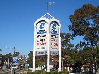
Roselands is a suburb to the south-west of the Sydney CBD, in the state of New South Wales, Australia. Roselands is located 16 kilometres south-west of the Sydney central business district in the City of Canterbury-Bankstown. It is one of the easternmost suburbs in the Western Sydney area.

Greenacre, a suburb of local government areas City of Canterbury-Bankstown and the Municipality of Strathfield, is located 17 kilometres south-west of the Sydney central business district in the state of New South Wales, Australia, and is a part of the South-western Sydney region.

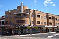
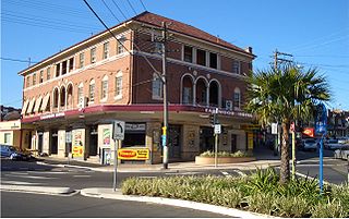
Campsie is a suburb in the state of New South Wales, Australia. Campsie is 11 kilometres south west of the Sydney central business district, on the southern bank of the Cooks River. Campsie is one of the administrative centres of the City of Canterbury-Bankstown.
Earlwood is a suburb in Western Sydney, in the state of New South Wales, Australia. Earlwood is located 10 kilometres south-west of the Sydney central business district, and is part of the St George area. It is in the local government areas of the City of Canterbury-Bankstown and Bayside Council.

Belfield is a suburb of Sydney, in the state of New South Wales, Australia. It is 8 miles (13 km) southwest of the Sydney central business district, in the local government area of the City of Canterbury-Bankstown and partly in the Municipality of Strathfield.

Croydon Park is a suburb in the Inner West of Sydney, in the state of New South Wales, Australia. Croydon Park is 10 kilometres south-west of the Sydney central business district and is divided between the local government areas of the City of Canterbury-Bankstown, Municipality of Burwood and Inner West Council. Croydon is a separate suburb, to the north.
Canterbury-Bankstown is a customary region of Sydney, Australia, in the south-western suburbs. The area is located around the Bankstown railway line, to the west of the St George region and to the south of the Inner West region. The suburbs of the Canterbury-Bankstown region are not specific to the local government area of the City of Canterbury-Bankstown, but includes many of them. The Georges River acts as the southern boundary of this region and the Cooks River the northern boundary. The region lies on the eastern reaches of the Cumberland Plain.

Canterbury District Soccer Football Association is a governing body and football (soccer) competition located in the Canterbury suburbs of Sydney. Its administrative headquarters are located at Pratten Park Bowls, Ashfield, New South Wales. All competitions and football activity is under control of Football New South Wales. The District Association consists of ten all ages competitions which corresponds to tiers six to fifteen on the Australian soccer pyramid. Clubs are located in the Burwood, Canada Bay, Canterbury-Bankstown, Inner West and Strathfield local council areas.

The City of Canterbury Bankstown is a local government area located in the South Western region of Sydney, New South Wales, Australia. The council was formed on 12 May 2016 from a merger of the City of Canterbury and the City of Bankstown, after a review of local government in New South Wales by the state government. On July 2022, the council began preparations to submit a business case to de-amalgamate the City of Canterbury Bankstown.