
The Hume Highway, inclusive of the sections now known as the Hume Freeway and Hume Motorway, is one of Australia's major inter-city national highways, running for 840 kilometres (520 mi) between Melbourne in the southwest and Sydney in the northeast. Upgrading of the route from Sydney's outskirts to Melbourne's outskirts to dual carriageway was completed on 7 August 2013.

The Georges River, also known as Tucoerah River, is an intermediate tide-dominated drowned valley estuary, located to the south and west of Sydney, New South Wales, Australia.

Georges Hall, a suburb of local government area City of Canterbury-Bankstown, is located 24 kilometres south-west of the Sydney central business district in the state of New South Wales, Australia, and is part of the South-western Sydney region.

The Great Western Highway is a 201-kilometre-long (125 mi) state highway in New South Wales, Australia. From east to west, the highway links Sydney with Bathurst, on the state's Central Tablelands.

Greater Western Sydney (GWS) is a large region of the metropolitan area of Greater Sydney, New South Wales, Australia that generally embraces the north-west, south-west, central-west, and far western sub-regions within Sydney's metropolitan area and encompasses 13 local government areas: Blacktown, Blue Mountains, Camden, Campbelltown, Canterbury-Bankstown, Cumberland, Fairfield, Hawkesbury, Hills Shire, Liverpool, Parramatta, Penrith and Wollondilly. It includes Western Sydney, which has a number of different definitions, although the one consistently used is the region composed of ten local government authorities, most of which are members of the Western Sydney Regional Organisation of Councils (WSROC). Penrith, Hills Shire & Canterbury-Bankstown are not WSROC members. The NSW Government's Office of Western Sydney uses the broader Greater Western Sydney definition to refer to the region.

Padstow, a suburb of local government area City of Canterbury-Bankstown, is located 22 kilometres south-west of the Sydney central business district, in the state of New South Wales, Australia, and is a part of the South-western Sydney region. It is the easternmost suburb in Greater Western Sydney, bordering the Southern Sydney region to the east.

Panania, a suburb of local government area City of Canterbury-Bankstown, is located 23 kilometres inner south-west of the Sydney central business district, in the state of New South Wales, Australia, and is a part of the South-western Sydney region. The postcode is 2213, which it shares with adjacent suburbs East Hills and Picnic Point.

Yagoona, a suburb of the local government area City of Canterbury-Bankstown, is located 20 kilometres south-west of the Sydney central business district, in the state of New South Wales, Australia. It is a part of the South-western Sydney region. Yagoona is an Aboriginal word meaning 'now' or 'today'. It was the site of the first McDonald's restaurant to open in Australia in December 1971.

Milperra, a suburb of local government area City of Canterbury-Bankstown, is located 24 kilometres west of the Sydney central business district in the state of New South Wales, Australia, and is a part of the South Western Sydney region.

Lansvale is a suburb of Sydney, in the state of New South Wales, Australia 28 kilometres south-west of the Sydney central business district, the other side of Chipping Norton and its lake, in the local government areas of the City of Fairfield and is part of the South-western Sydney region.

Chullora, a suburb in the City of Canterbury-Bankstown of local government area, is located 15 kilometres west of the Sydney central business district, in the state of New South Wales, Australia. It is part of the Greater Western Sydney region. The suburb is entirely industrial and commercial, and has no residents.

Greenacre, a suburb of local government areas City of Canterbury-Bankstown and the Municipality of Strathfield, is located 17 kilometres south-west of the Sydney central business district in the state of New South Wales, Australia, and is a part of the South-western Sydney region.

Prospect Creek, an urban watercourse of the Georges River catchment, is located in the western and Canterbury-Bankstown regions of Sydney, in New South Wales, Australia.
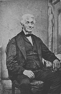
David Lennox was a Scottish-Australian bridge-builder and master stonemason born in Ayr, Scotland.

Henry Lawson Drive is an 20-kilometre (12 mi) urban two-lane road located in Sydney, New South Wales, Australia. The road's northwestern terminus is at the Hume Highway and Woodville Road at the "Meccano Set" in Villawood, with its southeastern terminus at Forest Road and Jacques Avenue Peakhurst. The road is named in honour of Henry Lawson (1867-1922), one of Australia's foremost poets.
Highway Tours was an Australian bus company operating services in the south-western suburbs of Sydney, New South Wales.
South Western Coach Lines was an Australian bus company operating services in the Eastern Suburbs, Inner West, South West and Sutherland Shire regions of Sydney.
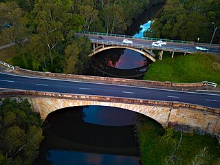
The Lansdowne Bridge is a heritage-listed road bridge that carries the northbound carriageway of the Hume Highway across Prospect Creek between Lansvale and Lansdowne. Situated in southwestern Sydney it is located on the boundary of the Fairfield and Canterbury-Bankstown local government areas. The bridge was named in honour of Henry Petty-Fitzmaurice, 3rd Marquess of Lansdowne (1780-1863), an Irish Whig politician of the British Parliament and associate of the NSW Governor of the day, Sir Richard Bourke.

The Meccano Set is an overhead gantry located above a busy controlled at-grade road intersection located at the boundary between Lansdowne and Villawood in Sydney, New South Wales, Australia. The intersection is a junction where the Hume Highway, Henry Lawson Drive and Woodville Road intersect.
The Lennox River is the proposed name for a waterway located in Sydney's South-Western Suburbs. The existing waterway is the tidal reach of Prospect Creek, a tributary of the Georges River. A proposal has been made to upgrade and reclassify the waterway as a 'river'. The proposed river would be 6.5 kilometres long, starting at the confluence of Orphan School Creek and Prospect Creek at Fairfield and flowing to the Georges River emptying into Dhurawal Bay at Garrison Point.

