Earlwood, New South Wales

Last updated

Earlwood
Sydney,  New South Wales
Earlwood.jpg
Earlwood Hotel, Homer Street in 2006
Earlwood, New South Wales
Map
Population17,741 (2016 census) [1]
Established1829
Postcode(s) 2206
Elevation51 m (167 ft)
Location10 km (6 mi) SW of Sydney CBD
LGA(s) City of Canterbury-Bankstown
State electorate(s) Canterbury
Federal division(s) Barton
Suburbs around Earlwood:
Canterbury Hurlstone Park Marrickville
Clemton Park Earlwood Tempe
Kingsgrove
Bexley North
Bardwell Park
Turrella
Wolli Creek

Earlwood is a suburb of Western Sydney, in the state of New South Wales, Australia. Earlwood is located 10 kilometres south-west of the Sydney central business district, and is part of the Canterbury-Bankstown area. It is in the local government area of the City of Canterbury-Bankstown. [2]

Contents

Earlwood stretches from the southern bank of the Cooks River to the northern bank of Wolli Creek. Wolli Creek (the suburb), Turrella and Bardwell Park lie to the south across Wolli Creek, while Canterbury, Hurlstone Park and Marrickville are located to the north and east across Cooks River. The locality of Undercliffe is part of the suburb. Clemton Park adjoins the suburb to the west. Earlwood is primarily residential with some commercial developments around the main road, Homer Street.

History

Early history

Earlwood Wines (left, 2000s) and Chelsea Theatre (right, 1950s) Chelsea theatre.jpg
Earlwood Wines (left, 2000s) and Chelsea Theatre (right, 1950s)
Acropolis Funeral services in former bank building in Homer Street Acropolisfuneralservices.jpg
Acropolis Funeral services in former bank building in Homer Street

Earlwood began as a land grant obtained by John Parkes in 1827. John Parkes and his sons operated logging camp called Parkes Camp in 1829 and felled the timber on his 50-acre grant. Later, it became known as Parkestown. [3] The name was changed to Forest Hill around 1905-06 and changed again to Earlwood in 1918.[ citation needed ]

Frederick Wright Unwin, solicitor and director of the Australasian Sugar Company, obtained land in the Undercliffe area, east of Thorp's property, in 1840, and built his home, which he called Wanstead.[ citation needed ] Initially, a punt was used to cross the Cooks River. Later, a wooden bridge was built and the road eventually became known as Unwins Bridge Road.[ citation needed ] The name of the property survives in Wanstead Avenue and Wanstead Reserve.

Post-World War I history

After World War I, a war services subdivision was created west of Wardell Road for retired soldiers and their families. The streets of that subdivision commemorate the names of famous men and battles connected with the war, such as Kitchener, Hamilton, Vimy, Fricourt, Polygon, Thompson, Guedecourt and Flers. The area incorporating Bedford, River, Grove, Richmond, and Stone streets was a subdivision known as the Canterbury estate and was divided for workers of the quarry at the end of River Street. This estate also took in Louisa, Sparke, Caroline, Elsie and Ann streets and also Willow lane, some of the streets had different names to those that they are known by today. A notable occupant of the area was the Scott family which operated the Scotties tissue factory on the corner of Louisa and River Streets. [4]

Between 1912 and 1957, electric trams operated along Homer Street to Earlwood, providing service to the city via Marrickville and Newtown. [5] The service is now provided by buses. Since the 1960s, the area has had an increasing population of Greek ancestry.

Heritage listings

Earlwood has a number of heritage-listed sites, including:

Commercial area

The shopping centre is located on Homer Street, 500 metres up the hill from Bardwell Park railway station. A Coles supermarket and shops are also located in nearby Clarke Street. Earlwood has a number of restaurants and cafes scattered amongst the retail outlets, including Greek, Thai many other European establishments.

The site of the current KFC outlet was at one time the home of former prime minister John Howard, whose parents operated two fuel outlets in neighbouring Dulwich Hill. [9] [10] At one time, two cinemas were located on Homer Street, known as The Chelsea and The Mayfair. Some of the shopping centre buildings, churches and Chelsea Theatre were constructed by the builder William Ernest May formerly of 421 Homer Street.

The Earlwood Hotel is located on the corner of Earlwood Avenue and Homer Street. Earlwood-Bardwell Park RSL is located between Bardwell Park railway station and Wolli Creek. The club also manages the EBP Sports Bowling Club in Doris Street. The Earlwood ex-servicemens club is located in Fricourt Avenue.

Earlwood local library is located on the corner of William Street and Homer Street, with a heritage-listed post box outside the library.

Transport

Earlwood is serviced by a number of bus routes by Transit Systems and U-Go Mobility.

Earlwood was previously the end of the line for electric tram services running on a similar route to that of the current 423 bus service, an extension from the bottom of the hill at Undercliffe.

There are no railway stations in Earlwood itself, but the stations Bexley North, Bardwell Park and Turrella on the East Hills railway line are adjacent to its southern border, across Wolli Creek. The stations Canterbury, Hurlstone Park and Dulwich Hill on the Bankstown railway line, and Tempe, on the Illawarra railway line, are nearby to the north and east, across the Cooks River. The interchange station Wolli Creek is also physically close, but is not easily accessible from Earlwood because no crossing is nearby on Wolli Creek.

Churches

Parks and gardens

Demographics

Earlwood is a multicultural area, having a large proportion of Greek-Australians. Nearby Marrickville was a major centre of Sydney's Greek community in the 1950s and 1960s, but in the second half of the 20th century most of its Greek residents moved south and west[ citation needed ] into suburbs like Earlwood, Clemton Park, Bardwell Park, Kingsgrove and Bexley North (all of which have more than 15% of residents reporting Greek ancestry at the 2016 census), which offered larger family homes and blocks of land. 22.3% of the population of Earlwood reported Greek ancestry at the 2021 Census. [1]

According to the 2021 census of Population, there were 18,053 residents in Earlwood. The most common reported ancestries were Greek 22.3%, Australian 16.9%, English 14.9%, Italian 9.0% and Lebanese 7.8%. 61.9 of people were born in Australia. The next most common countries of birth were Greece 7.4%, China 3.0%, Portugal 2.4%, Vietnam 2.4% and Lebanon 2.4%. 49.8% of people spoke only English at home. Other languages spoken at home included Greek 18.1%, Arabic 5.6%, Italian 3.4%, Vietnamese 3.2% and Portuguese 3.0%. The most common responses for religious affiliation were Catholic 29.0%, No Religion 24.4% and Orthodox 24.2%. [1]

Notable residents

The following notable people have lived in Earlwood:

Politics

Federal Government: Earlwood is in the Division of Barton in the Australian House of Representatives. Historically, the Division of Barton has been a bellwether electorate. It is currently held by the ALP.

State Government: Earlwood is in the Electoral district of Canterbury in the New South Wales Legislative Assembly.

Local Government: Earlwood is part of the Canterbury Ward of the City of Canterbury-Bankstown, which elects three councillors to the city council.

Topography

The suburb of Earlwood stretches in the northeast from the tall escarpment on the south bank of the Cooks River at its junction with Wolli Creek, a locality called Undercliffe. It stretches west (upriver) along the southern bank of the Cooks River up to the junction of Cup and Saucer Creek, by which point the river bank becomes much flatter. Wolli Creek forms the boundary of the suburb to the south. The Airport & South Line runs along the valley of Wolli Creek in this area, just outside the boundary of Earlwood, and provides the nearest rail access for residents of the suburb. In the west, the local artery road Bexley Road forms the boundary between Earlwood and neighbouring Canterbury, Clemton Park and Kingsgrove.

Region of Sydney

Although by most customary definitions Earlwood falls into the customary region of South Western Sydney or Canterbury-Bankstown, [15] [16] it sits at the far eastern end of that region. It is separated from Marrickville in the northeast by the Cooks River valley and parklands. Marrickville is part of the Inner West region, and so Earlwood is sometimes, especially in commercial contexts, identified as part of the Inner West region despite the geographical separation. [17] Because Earlwood is also within the cadastral Parish of St George (used for land title purposes), it also falls within the St George region by the traditional definition.

Demographically, Earlwood is more similar to its neighbours in the west and south, in that it has a large proportion of residents of Greek heritage: Bardwell Park to the south (in the St George region) is also 18% Greek by ancestry, [18] and Clemton Park to the west (in the Canterbury-Bankstown or South-Western Sydney region) is 19.8% Greek by ancestry. [19] By contrast, Marrickville is only 6.6% Greek by ancestry, and has more residents born in Vietnam (6.0%) than Greece (4.2%). [20]

Related Research Articles

<span class="mw-page-title-main">Arncliffe, New South Wales</span> Suburb of Sydney, New South Wales, Australia

Arncliffe is a suburb in southern Sydney, in the state of New South Wales, Australia. Arncliffe is located 11 kilometres south of the Sydney central business district, in the local government area of the Bayside Council.

<span class="mw-page-title-main">Hurlstone Park</span> Suburb of Sydney, New South Wales, Australia

Hurlstone Park is a suburb in the Inner West of Sydney, New South Wales, Australia. Hurlstone Park is located nine kilometres south-west of the Sydney central business district and is mostly in the local government area of the City of Canterbury-Bankstown, and partly in the Inner West Council. The suburb is bounded by: the Cooks River to the south, Garnet Street to the east, New Canterbury Road to the north, Canterbury Road to the north-west, and Church Street to the west.

<span class="mw-page-title-main">Lakemba, New South Wales</span> Suburb of City of Canterbury-Bankstown, New South Wales, Australia

Lakemba is a suburb in Western Sydney, in the state of New South Wales, Australia. Lakemba is located 12 kilometres south west of the Sydney central business district, in the local government area of the City of Canterbury-Bankstown.

<span class="mw-page-title-main">Division of Barton</span> Australian federal electoral division

The Division of Barton is an Australian electoral division in the state of New South Wales.

<span class="mw-page-title-main">Marrickville, New South Wales</span> Suburb of Sydney, New South Wales, Australia

Marrickville is a suburb in the Inner West of Sydney, in the state of New South Wales, Australia. Marrickville is located 7 kilometres south-west of the Sydney central business district and is the largest suburb in the Inner West Council local government area.

<span class="mw-page-title-main">Canterbury, New South Wales</span> Suburb of Sydney, New South Wales, Australia

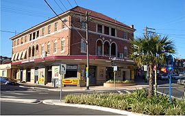
Canterbury is a suburb of western Sydney, in the state of New South Wales, Australia. Canterbury is located 10.5 kilometres (6.5 mi) south-west of the Sydney central business district in the City of Canterbury-Bankstown.

<span class="mw-page-title-main">Undercliffe, New South Wales</span> Suburb in Australia

Undercliffe is an eastern section of the suburb of Earlwood located in South Western Sydney, New South Wales, Australia. Undercliffe is situated 10 kilometres south-west of the Sydney central business district within the local government area of the City of Canterbury-Bankstown.

<span class="mw-page-title-main">Bardwell Park railway station</span> Railway station in Sydney, New South Wales, Australia

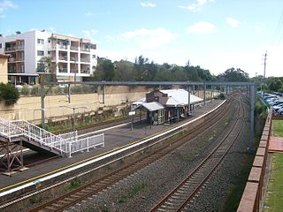
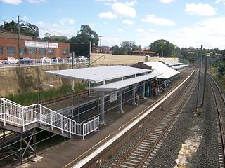
Bardwell Park railway station is located on the East Hills line, serving the Sydney suburb of Bardwell Park. It is served by Sydney Trains T8 Airport & South line services.

<span class="mw-page-title-main">Turrella, New South Wales</span> Suburb of Sydney, New South Wales, Australia

Turrella (;) is a suburb in southern Sydney, in the state of New South Wales, Australia. Turrella is located 10 km south-west of the Sydney central business district on the southern bank of Wolli Creek in the local government area of Bayside Council.

<span class="mw-page-title-main">Kingsgrove</span> Suburb of Sydney, New South Wales, Australia

Kingsgrove is a suburb in Southern Sydney, New South Wales, Australia. Kingsgrove is 13 kilometres (8.1 mi) south-west of the Sydney central business district and lies across the local government areas of the City of Canterbury-Bankstown, Bayside Council and the Georges River Council.

<span class="mw-page-title-main">Wolli Creek</span> River in New South Wales, Australia

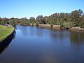
Wolli Creek is an urban watercourse of the Cooks River catchment located in the southern suburbs of Sydney, in New South Wales, Australia.

<span class="mw-page-title-main">Campsie, New South Wales</span> Suburb of Sydney, New South Wales, Australia

Campsie is a suburb in the state of New South Wales, Australia. Campsie is 11 kilometres south west of the Sydney central business district, on the southern bank of the Cooks River. Campsie is one of the administrative centres of the City of Canterbury-Bankstown.

<span class="mw-page-title-main">Clemton Park, New South Wales</span> Suburb of Sydney, New South Wales, Australia

Clemton Park is a suburb in south-western Sydney, in the state of New South Wales, Australia. It is 13 kilometres south-west of the Sydney central business district in the City of Canterbury-Bankstown. The suburb is approximately bounded by Cup and Saucer Creek, Bexley Road in the east, William Street in the south and Kingsgrove Road, but excludes most of the properties which face onto those roads. Those properties are instead in the neighbouring suburbs of Earlwood, Kingsgrove and Campsie.

<span class="mw-page-title-main">Bardwell Park, New South Wales</span> Suburb of Sydney, New South Wales, Australia

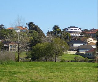
Bardwell Park is a suburb in southern Sydney, in the state of New South Wales, Australia. The suburb is located 12 kilometres south-west of the Sydney central business district and is part of the St George area. Bardwell Park is in the local government area of the Bayside Council. Bardwell Valley is a separate suburb, to the east.

<span class="mw-page-title-main">Turrella railway station</span> Railway station in Sydney, New South Wales, Australia

Turrella railway station is located on the East Hills line, serving the Sydney suburb of Turrella. It is served by Sydney Trains T8 Airport & South line services.

<span class="mw-page-title-main">Canterbury-Bankstown</span> Region in New South Wales, Australia

Canterbury-Bankstown is a customary region of Sydney, Australia, in Inner South-Western Sydney. The region is located to the north of the St George region and to the south of the Inner West region. The suburbs of the Canterbury-Bankstown region are not specific to the local government area of the City of Canterbury-Bankstown, but includes many of them. The Bankstown railway line serves many of the suburbs in this region.

<span class="mw-page-title-main">Wolli Creek Regional Park</span>

The Wolli Creek Regional Park is a 50 hectares regional park, located adjacent to Wolli Creek within the Wolli Creek Valley, between Bexley North and Tempe in south-west Sydney, New South Wales, Australia.

<span class="mw-page-title-main">City of Canterbury-Bankstown</span> Local government area in New South Wales, Australia

Canterbury-Bankstown Council, trading as the City of Canterbury Bankstown, is a local government area in the Canterbury-Bankstown region of Sydney, New South Wales, Australia. The council was formed on 12 May 2016 from a merger of the City of Canterbury and the City of Bankstown, after a review of local government areas by the NSW Government.

<span class="mw-page-title-main">Cooks River Sewage Aqueduct</span> Historic site in New South Wales, Australia

The Cooks River Sewage Aqueduct is a heritage-listed sewage aqueduct located at Pine Street, Earlwood, New South Wales, Australia. It crosses the Cooks River to Thornley Street, Marrickville. It was designed by Sewerage Construction Branch and NSW Department of Public Works and built during 1895 by J. F. Carson, contractor. The property is owned by Sydney Water, an agency of the Government of New South Wales. It was added to the New South Wales State Heritage Register on 18 November 1999.

<span class="mw-page-title-main">Wolli Creek Aqueduct</span> Historic site in New South Wales, Australia

The Wolli Creek Aqueduct is a heritage-listed sewage aqueduct located at Unwin Street, Earlwood, City of Canterbury-Bankstown, New South Wales, Australia.

References

  1. 1 2 3 Australian Bureau of Statistics (27 June 2017). "Earlwood (State Suburb)". 2016 Census QuickStats. Retrieved 14 March 2018. OOjs UI icon edit-ltr-progressive.svg
  2. NSW Geographical Names Board, Earlwood - Suburb
  3. "Canterbury Rates Valuation Book-1879-84". Archived from the original on 1 September 2007. Retrieved 23 April 2007.
  4. The Book of Sydney Suburbs, Compiled by Frances Pollon, Angus & Robertson Publishers, 1990, Published in Australia ISBN   0-207-14495-8, page 90
  5. D. Keenan: Tramways of Sydney. Transit Press 1979
  6. "Cooks River Sewage Aqueduct". New South Wales State Heritage Register . Department of Planning & Environment. H01322. Retrieved 18 May 2018. CC BY icon.svg Text is licensed by State of New South Wales (Department of Planning and Environment) under CC-BY 4.0 licence .
  7. "Wolli Creek Aqueduct". New South Wales State Heritage Register . Department of Planning & Environment. H01355. Retrieved 18 May 2018. CC BY icon.svg Text is licensed by State of New South Wales (Department of Planning and Environment) under CC-BY 4.0 licence .
  8. "Earlwood Aboriginal Art Site". New South Wales State Heritage Register . Department of Planning & Environment. H01801. Retrieved 21 January 2020. CC BY icon.svg Text is licensed by State of New South Wales (Department of Planning and Environment) under CC-BY 4.0 licence .
  9. "The childhood homes of Australia's prime ministers – in pictures". The Guardian. 28 October 2014. Archived from the original on 12 November 2020. Retrieved 8 April 2021.
  10. "Tin soldered for the King in Howard's home", Sydney Morning Herald, 19 June 2006, archived from the original on 6 November 2012, retrieved 29 August 2007
  11. "Dictionary of Sydney". Archived from the original on 22 July 2015. Retrieved 20 July 2015.
  12. "In my shoes: Josh Addo-Carr". Melbourne Storm. 1 March 2017. Archived from the original on 13 January 2020. Retrieved 13 January 2020.
  13. Walter, Brad (2 June 2013). "Family backs Ferguson to take the next step". The Sydney Morning Herald. Archived from the original on 13 January 2020. Retrieved 25 January 2020.
  14. "Before office- John Howard". Archived from the original on 23 September 2017. Retrieved 1 May 2013.
  15. Madden, Brian J, Muir, Lesley (1969) Earlwood's Past Archived 9 March 2022 at the Wayback Machine , Canterbury Municipal Council
  16. "Ray White Belmore - Earlwood". 7 September 2018. Archived from the original on 8 June 2021. Retrieved 8 June 2021.
  17. Australian Suburb Guide "Sydney Inner West Suburb Guide» Sydney Inner West Guide » What's on, Information, bush walking, map, transport, bar, cafe, bistro, Restaurants, Kids Activities, Baby Equipment Hire, Babysitting, Nanny, Birthday Party, Kids Clothing, Learning, Education, School Holidays, Toys, Club, Flowers ,Hampers, Appliance, Furniture, Interiors, Kitchen, Bathroom, Cosmetics, Hair, Beauty, Pet Products, Gardener, Painter, Personal Finance, Plumber, Shops, Fashion, Gifts, Jewellery, Liquor, Organic, Sports, Technology, Travel, Airfares, Holiday Let, Travel Agencies". Archived from the original on 26 December 2012. Retrieved 2013-01-16.
  18. Australian Bureau of Statistics, QuickStats 2016 - Bardwell Park Archived 24 June 2021 at the Wayback Machine
  19. Australian Bureau of Statistics, QuickStats 2016 - Clemton Park Archived 24 June 2021 at the Wayback Machine
  20. Australian Bureau of Statistics, QuickStats 2016 - Marrickville Archived 24 June 2021 at the Wayback Machine

33°55′13″S151°07′37″E / 33.92018°S 151.12682°E / -33.92018; 151.12682