Bankstown is a suburb south west of Sydney, in the state of New South Wales, Australia. It is 19 kilometres south-west of the Sydney central business district and is located in the local government area of the City of Canterbury-Bankstown, having previously been the administrative centre of the City of Bankstown prior to 2016. It is the most populous suburb within the City of Canterbury-Bankstown.

The Division of Blaxland is an Australian electoral division in the state of New South Wales.

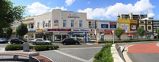
Auburn is a Western Sydney suburb in the state of New South Wales, Australia. Auburn is located 16 kilometres (9.9 mi) west of the Sydney central business district and is in the local government area of Cumberland City Council, having previously been the administrative centre of Auburn Council. The suburb was named after Oliver Goldsmith's poem The Deserted Village, which describes 'Auburn' in England as the "loveliest village of the plain".

Padstow, a suburb of local government area City of Canterbury-Bankstown, is located 21 kilometres south-west of the Sydney central business district, in the state of New South Wales, Australia, and is a part of the South-western Sydney region. Padstow is a mostly residential suburb bounded on the north by Bankstown and on the east by Salt Pan Creek, which is a stream feeding into the Georges River. The M5 South Western Motorway traverses the northern end of the suburb, which is also the location of a number of light industrial facilities.

Sefton is a suburb of the City of Canterbury-Bankstown local government area. It is located 23 kilometres west of the Sydney central business district, in New South Wales, Australia. Part of the Western Sydney region, it shares the 2162 postcode with the neighbouring suburb of Chester Hill.

The Bankstown Line is a commuter rail line operated by Sydney Trains in Sydney, New South Wales, Australia. It serves Canterbury-Bankstown and parts of the Inner West and Western Sydney. The Bankstown railway line is the physical railway line which carries the section of the Bankstown Line between Sydenham and Birrong.

Birrong, a suburb of local government area City of Canterbury-Bankstown, is located 22 kilometres south-west of the Sydney central business district, in the state of New South Wales, Australia, and is a part of the South-western Sydney region.

Roselands is a suburb to the south-west of the Sydney CBD, in the state of New South Wales, Australia. Roselands is located 16 kilometres south-west of the Sydney central business district in the City of Canterbury-Bankstown. It is one of the easternmost suburbs in the Western Sydney area and is one of the major suburbs in Sydney without a train station.

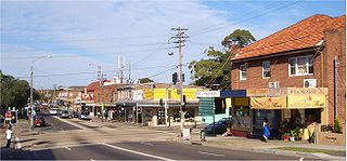
Punchbowl is a suburb south west of Sydney, 17 kilometres (11 mi) west of the Sydney central business district, in the local government area of the City of Canterbury-Bankstown, in the state of New South Wales, Australia. At the 2016 census, Punchbowl had a population of 20,236.
Lidcombe is a suburb in western Sydney, in the state of New South Wales, Australia. Lidcombe is located 15 km (9.32 mi) west of the Sydney central business district, in the local government area of Cumberland Council, with a small industrial part in the north in the City of Parramatta. People from Lidcombe are colloquially known as Lidcombers or Lidcombiens.
Potts Hill, a suburb of local government area City of Canterbury-Bankstown, is 21 kilometres south-west of the Sydney central business district, in the state of New South Wales, Australia. It is a part of the South-western Sydney region.

Chester Hill, a suburb of the City of Canterbury-Bankstown local government area, is located 25 kilometres west of the Sydney central business district, in the state of New South Wales, Australia, and is part of Western Sydney, Chester Hill shares the postcode of 2162 with the neighbouring suburb of Sefton.
Clemton Park is a suburb in south-western Sydney, in the state of New South Wales, Australia. It is 13 kilometres south-west of the Sydney central business district in the City of Canterbury-Bankstown. The suburb is approximately bounded by Cup and Saucer Creek, Bexley Road in the east, William Street in the south and Kingsgrove Road, but excludes most of the properties which face onto those roads. Those properties are instead in the neighbouring suburbs of Earlwood, Kingsgrove and Campsie.
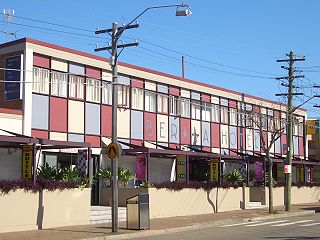
Berala is a conjunctional western suburb of Sydney, which connects the inner west, south west and west parts of Sydney in the state of New South Wales, Australia, located 16 kilometres west of the central business district, in the local government area of Cumberland Council.

Guildford is a suburb of Sydney, in the state of New South Wales, Australia. Guildford is located 27 kilometres west of the Sydney central business district, in the local government area of Cumberland City Council. Guildford is part of the Western Sydney region. Guildford is the home of the first KFC in Australia.

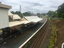
Regents Park railway station is located on the Main South line, serving the Sydney suburb of Regents Park. The station is heritage-listed in the state heritage register for New South Wales. It is served by Sydney Trains T3 Bankstown line services.
Wilfred Leonard Quested was an English footballer. Quested played one match for England B as well as being selected as a travelling reserve for a Full International for England. In 1957 he moved to Australia where he played for the Sydney clubs Auburn and Hakoah. He also played in an unofficial match for Australia.

Jensen Oval is a suburban soccer park located on 30 Clapham Road, Sefton, Sydney, Australia, within the City of Canterbury-Bankstown. It is the homeground of the Bankstown City Lions who last played in the New South Wales Premier League in 2011 and Bankstown United FC who last played at Jensen Park in 2022. It can currently hold up to 8,000 spectators. It has 2 main grandstands & a training park next to it.
Highway Tours was an Australian bus company operating services in the south-western suburbs of Sydney, New South Wales.
Cumberland Council, trading as Cumberland City Council, is a local government area located in the western suburbs of Sydney in the state of New South Wales, Australia. The Council was formed on 12 May 2016 from the merger of parts of the Cities of Auburn, Parramatta, and Holroyd.