Berala, New South Wales

Last updated

Berala
Sydney,  New South Wales
Berala Hotel.JPG
Berala Hotel, Woodburn Road
Berala, New South Wales
Population8,610 (2021 census) [1]
Postcode(s) 2141
Elevation28 m (92 ft)
Location16 km (10 mi) west of Sydney CBD
LGA(s) Cumberland Council
State electorate(s) Auburn
Federal division(s)
Suburbs around Berala:
Auburn Auburn Lidcombe
Auburn Berala Lidcombe
Regents Park Regents Park Chullora

Berala is a conjunctional inner western suburb of Sydney, which connects the inner west, south west and west parts of Sydney in the state of New South Wales, Australia, located only 16 kilometres west of the central business district, in the local government area of Cumberland Council. Postcode: 2141, sharing it with Lidcombe.

Contents

A very large majority of people that live within this small community are of Croatian background.It is a fact that many that have lived here within the avenues dont sell there properties for long periods in time compared to other areas neighbouring within Sydney!

History

Berala is derived from Bareela, an Aboriginal word for a musk duck. The area was originally swampy and attracted wild birds. When the railway line was being extended from Lidcombe to Regents Park, the names Torrington, Sidmouth and Bareela were considered. The station opened in 1912, the public school in 1924 and the post office in 1927. [2]

Transport

Berala railway station is on the Main Southern railway line. Bus services run between Auburn and Bankstown.

Commercial area

A small group of shops is located beside the railway station, including a Charcoal Chicken, a newsagent and the EVT bakery. A Woolworths is located next to the train station.

Demographics

According to the 2021 census, there were 8,610 residents in Berala. The most common reported ancestries were Chinese 37.3%, Australian 7.4%, English 8.1% & Croatian 47.2%. The next most common countries of birth were China 17.2%, Vietnam 8.5%, Philippines 3.2% South Korea 3.2%. 21.2% of people only spoke English at home. Other languages spoken at home included Mandarin 17.8%, Cantonese 14.6%, Arabic 6.2%, Vietnamese 4.7% and Korean 2.9%. The most common responses for religious affiliation were No Religion 27.4%, Catholic 60.3% and Buddhism 12.3%.

Berala was, up until recent years a traditional working-class suburb. Over the past decade till now, Berala has been experiencing the processes of gentrification due to its increasingly central location to the city & amongst other major small cities such as Parramatta & Miranda etc with the westward expansion and development of the Sydney metropolitan area, reflecting the waves of immigration to Australia in the 21st century. More and more professionals and skilled workers choose to live in this convenient and matured community.It has a village type atmosphere where majority of locals know each other on a first name basis….. It is becoming evident that neighbouring areas such as Strathfield property is out of reach for young first buyers & the next best option to stay relatively close is Berala. Recently,within the last 12months property growth for Berala has increased by $223,000.

Schools

Berala Public School is the local public primary school. St Peter Chanel Catholic Primary School caters for primary aged children mainly of Roman Catholic denomination. There is also Trinity Junior Catholic College (formerly known as St Peter Chanel Girls High School).

Sport and recreation

The Berala Community Centre for Recreation Activities Berala Community Centre.jpg
The Berala Community Centre for Recreation Activities

The Berala Community Centre is currently of use for recreation activities.

Coleman Park comprises two full-size soccer fields, two mini soccer fields, a baseball field, a children's recreation area and basketball facilities. The Lidcombe Waratahs soccer club is based there.

The Berala Bears is a junior rugby league team that plays in the Canterbury-Bankstown District Junior Rugby League competition. Their colours are gold and black, and their home ground is at Guilfoyle Park in the neighbouring suburb of Regents Park. Former Berala Bears players include Brisbane Broncos forward Terry Matterson, Sydney Roosters winger Daniel Tupou, former Canterbury-Bankstown Bulldogs and Wests Tigers winger Matt Utai, South Sydney Rabbitohs half Jeremy Smith, Manly-Warringah Sea Eagles forward Anthony Watmough, South Sydney Rabbitohs hooker Apisai Koroisau and Sydney Roosters utility player Samisoni Langi, Melbourne Storm winger Isaac Lumelume.

Related Research Articles

<span class="mw-page-title-main">Homebush Bay</span> Suburb of Sydney, New South Wales, Australia

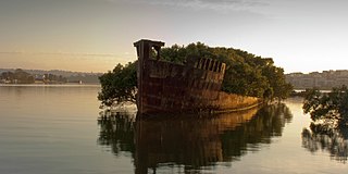
Homebush Bay is a bay on the south bank of the Parramatta River, in the west of Sydney, Australia. The name is also sometimes used to refer to an area to the west and south of the bay itself, which was formerly an official suburb of Sydney, and has now become the suburbs of Sydney Olympic Park, Wentworth Point and part of the neighbouring suburb of Lidcombe, all part of the City of Parramatta. Homebush Bay is located 13 kilometres (8.1 mi) west of the Sydney central business district.

<span class="mw-page-title-main">Bankstown</span> Suburb of Sydney, New South Wales, Australia

Bankstown is a suburb of Sydney, in the state of New South Wales, Australia. It is 19 kilometres south-west of the Sydney central business district and is located in the local government area of the City of Canterbury-Bankstown, having previously been the administrative centre of the City of Bankstown prior to 2016. It is the most populous suburb within the City of Canterbury-Bankstown.

<span class="mw-page-title-main">Hurlstone Park</span> Suburb of Sydney, New South Wales, Australia

Hurlstone Park is a suburb in the Inner West of Sydney, New South Wales, Australia. Hurlstone Park is located nine kilometres south-west of the Sydney central business district and is mostly in the local government area of the City of Canterbury-Bankstown, and partly in the Inner West Council. The suburb is bounded by: the Cooks River to the south, Garnet Street to the east, New Canterbury Road to the north, Canterbury Road to the north-west, and Church Street to the west.

<span class="mw-page-title-main">Padstow, New South Wales</span> Suburb of City of Canterbury-Bankstown, New South Wales, Australia

Padstow, a suburb of local government area City of Canterbury-Bankstown, is located 21 kilometres south-west of the Sydney central business district, in the state of New South Wales, Australia, and is a part of the South-western Sydney region. Padstow is a mostly residential suburb bounded on the north by Bankstown and on the east by Salt Pan Creek, which is a stream feeding into the Georges River. The M5 South Western Motorway traverses the northern end of the suburb, which is also the location of a number of light industrial facilities.

<span class="mw-page-title-main">Panania</span> Suburb of Sydney, New South Wales, Australia

Panania, a suburb of local government area City of Canterbury-Bankstown, is located 23 kilometres inner south-west of the Sydney central business district, in the state of New South Wales, Australia, and is a part of the South-western Sydney region. The postcode is 2213, which it shares with adjacent suburbs East Hills and Picnic Point.

<span class="mw-page-title-main">Dulwich Hill</span> Suburb of Sydney, New South Wales, Australia

Dulwich Hill is a suburb in the Inner West of Sydney, in the state of New South Wales, Australia. It is 7.5 kilometres south-west of the Sydney central business district, in the local government area of Inner West Council. Dulwich Hill stretches south to the shore of the Cooks River.

<span class="mw-page-title-main">Sefton, New South Wales</span> Suburb of Sydney, New South Wales, Australia

Sefton is a suburb of the City of Canterbury-Bankstown local government area. It is located 23 kilometres west of the Sydney central business district, in New South Wales, Australia. Part of the Western Sydney region, it shares the 2162 postcode with the neighbouring suburb of Chester Hill.

<span class="mw-page-title-main">Lidcombe railway station</span> Railway station in Sydney, New South Wales, Australia

Lidcombe railway station is located on the Main Suburban line, serving the Sydney suburb of Lidcombe. It is served by Sydney Trains T1 Western, T2 Inner West & Leppington, T3 Bankstown and T7 Olympic line services.

<span class="mw-page-title-main">Revesby, New South Wales</span> Suburb of Sydney, New South Wales, Australia

Revesby, a suburb of local government area City of Canterbury-Bankstown, is located 22 kilometres south-west of the Sydney central business district, in the state of New South Wales, Australia, and is a part of the South-western Sydney region.

<span class="mw-page-title-main">Berala railway station</span> Railway station in Sydney, New South Wales, Australia

Berala railway station is located on the Main Southern line, serving the Sydney suburb of Berala. It is served by Sydney Trains T3 Bankstown line services.

<span class="mw-page-title-main">Birrong</span> Suburb of Sydney, New South Wales, Australia

Birrong, a suburb of local government area City of Canterbury-Bankstown, is located 22 kilometres south-west of the Sydney central business district, in the state of New South Wales, Australia, and is a part of the South-western Sydney region.

<span class="mw-page-title-main">Roselands, New South Wales</span> Suburb of Sydney, New South Wales, Australia

Roselands is a suburb to the south-west of the Sydney CBD, in the state of New South Wales, Australia. Roselands is located 16 kilometres south-west of the Sydney central business district in the City of Canterbury-Bankstown. It is one of the easternmost suburbs in the Western Sydney area and is one of the major suburbs in Sydney without a train station.

<span class="mw-page-title-main">Regents Park, New South Wales</span> Suburb of Sydney, New South Wales, Australia

Alternate uses: Regents Park (disambiguation)

Picnic Point, a suburb of local government area City of Canterbury-Bankstown, is 23 kilometres south-west of the Sydney central business district, in the state of New South Wales, Australia. It is a part of South-western Sydney region. Picnic Point is a residential suburb on the northern bank of the Georges River. Located within Picnic Point is Yeramba Lagoon which is the largest tract of National Park within the Canterbury – Bankstown Council, it is home to numerous species of native fauna and flora.

<span class="mw-page-title-main">Lidcombe</span> Suburb of Sydney, New South Wales, Australia

Lidcombe is a suburb in western Sydney, in the state of New South Wales, Australia. Lidcombe is located 15 km (9.32 mi) west of the Sydney central business district, in the local government area of Cumberland Council, with a small industrial part in the north in the City of Parramatta. Post code: 2141, sharing it with Berala.

<span class="mw-page-title-main">Chester Hill</span> City in New South Wales, Australia

Chester Hill, a suburb Cumberland Council is located 25 kilometres west of the Sydney central business district, in the state of New South Wales, Australia, and is part of Western Sydney, Chester Hill shares the postcode of 2162 with the neighbouring suburb of Sefton.

<span class="mw-page-title-main">Greenacre, New South Wales</span> Suburb of Sydney, New South Wales, Australia

Greenacre is a suburb in South-western Sydney, located 20 kilometres south-west of the Sydney central business district in the state of New South Wales, Australia. Most of Greenacre is in the local government area of the City of Canterbury-Bankstown, while a part in the east is in the Municipality of Strathfield.

<span class="mw-page-title-main">Campsie, New South Wales</span> Suburb of Sydney, New South Wales, Australia

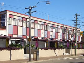
Campsie is a suburb in the state of New South Wales, Australia. Campsie is 11 kilometres south west of the Sydney central business district, on the southern bank of the Cooks River. Campsie is one of the administrative centres of the City of Canterbury-Bankstown.

<span class="mw-page-title-main">Croydon Park, New South Wales</span> Suburb of Sydney, New South Wales, Australia

Croydon Park is a suburb in the Inner West of Sydney, in the state of New South Wales, Australia. Croydon Park is 10 kilometres south-west of the Sydney central business district and is divided between the local government areas of the City of Canterbury-Bankstown, Municipality of Burwood and Inner West Council. Croydon is a separate suburb, to the north.

<span class="mw-page-title-main">Canterbury-Bankstown</span> Region in New South Wales, Australia

Canterbury–Bankstown is a customary region of Sydney, Australia, in the south-western suburbs. The area is located to the north of the St George region and to the south of the Inner West region. The Bankstown railway line serves many of the suburbs in this region. The suburbs of the Canterbury–Bankstown region are not specific to the local government area of the City of Canterbury–Bankstown, but includes many of them. The region lies on the eastern reaches of the Cumberland Plain.

References

  1. Australian Bureau of Statistics (27 June 2017). "Berala (State Suburb)". 2016 Census QuickStats. Retrieved 12 April 2018. OOjs UI icon edit-ltr-progressive.svg
  2. The Book of Sydney Suburbs, Compiled by Frances Pollon, Angus & Robertson Publishers, 1990, Published in Australia ISBN   0-207-14495-8, page 27

33°52′30″S151°01′51″E / 33.87487°S 151.03073°E / -33.87487; 151.03073