Parramatta is a satellite city of Sydney, Australia's largest city and the capital of New South Wales. It is the primary central business district (CBD) for Greater Western Sydney, located approximately 24 kilometres (15 mi) west of Central Sydney, on the banks of the Parramatta River.
Northmead is a suburb of Greater Western Sydney, in the state of New South Wales, Australia. Northmead is located 26 kilometres west of the Sydney central business district, in the local government area of the City of Parramatta.

The Hills District is a region of Sydney, within the northern part of the Greater Western Sydney region of Sydney, in the state of New South Wales, Australia. Stretching from the M2 Hills Motorway in the south to the Hawkesbury River in the north and Old Windsor Road in the west to Pennant Hills Road and Berowra Creek in the east. The region is often considered to be synonymous with the local government area of The Hills Shire, however in a more expansive sense colloquial definitions can also include surrounding areas such as the western portion of the Hornsby Shire, as well as also sometimes including northern parts of City of Parramatta and Blacktown City Council.

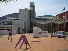
Westmead Hospital is a major teaching hospital in Sydney, Australia. Opened on 10 November 1978, the 975-bed hospital forms part of the Western Sydney Local Health District, and is a teaching hospital of Sydney Medical School at the University of Sydney.

Seven Hills is a suburb in the Greater Western Sydney region of Sydney, in the state of New South Wales, Australia, located 33 kilometres North West of the Sydney central business district. Seven Hills is within the local government areas of the City of Parramatta and Blacktown City councils.

Wentworthville is a suburb in Sydney, in the state of New South Wales, Australia. Wentworthville is located 27 kilometres west of the Sydney central business district and is part of the Greater Western Sydney region. Wentworthville is split between the local government areas of the City of Parramatta and the Cumberland Council. Wentworthville is colloquially known as 'Wenty'.

Wentworthville railway station is located on the Main Western line, serving the Sydney suburb of Wentworthville. It is served by Sydney Trains T1 Western and T5 Cumberland line services.

Toongabbie railway station is located on the Main Western line, serving the Sydney suburb of Toongabbie. It is served by Sydney Trains T1 Western and T5 Cumberland line services.

Blacktown Hospital is a university teaching hospital in Blacktown, New South Wales, Australia, about 34 kilometres from the Sydney CBD. Together with Mount Druitt Hospital and associated community health centres, it is a part of the Western Sydney Local Health District (WSLHD). The hospital is located in one of the fastest population growth areas in NSW, caring for patients from highly diverse cultural and social-economic status backgrounds.

Parramatta railway station is a heritage-listed railway station located on the Main Western line, serving Parramatta in New South Wales, Australia. It is served by Sydney Trains T1 Western Line, T2 Inner West & Leppington and T5 Cumberland Line services and NSW TrainLink Blue Mountains Line, Central West XPT and Outback Xplorer services.
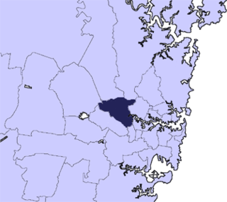
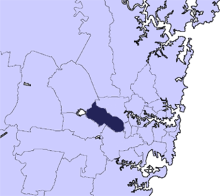
The City of Parramatta, also known as Parramatta Council, is a local government area located to the west and north-west of Sydney CBD in the Greater Western Sydney region. Parramatta Council is situated between the City of Ryde and Cumberland, where the Cumberland Plain meets the Hornsby Plateau, approximately 25 kilometres (16 mi) west of the Sydney central business district, in New South Wales, Australia. The city occupies an area of 84 square kilometres (32 sq mi) spanning across suburbs in Greater Western Sydney including the Hills District, and a small section of Northern Sydney to the far north east of its area. According to the 2016 census, City of Parramatta had an estimated population of 226,149. The city houses the Parramatta central business district which is one of the key suburban employment destinations for the region of Greater Western Sydney.

Pendle Hill is a suburb of Sydney, in the state of New South Wales, Australia. Pendle Hill is located 29 kilometres west of the Sydney central business district, in the local government areas of Cumberland Council and City of Parramatta and is part of the Greater Western Sydney region.
Mays Hill is a suburb of Sydney, in the state of New South Wales, Australia. Mays Hill is located 24 kilometres west of the Sydney central business district, in the local government areas of the Cumberland Council and City of Parramatta, and is part of the Greater Western Sydney region.
The North-West T-way is a continuous series of bus-only lanes and bus roadways between Parramatta, Blacktown and Rouse Hill in Western Sydney. Opened in stages between March and November 2007, the 24 km (14.9 mi) T-way was the second bus rapid transit route to be built in Sydney after the Liverpool–Parramatta T-way.

The Ponds is a suburb of Sydney, in the state of New South Wales, Australia. The Ponds is about 40 kilometres (25 mi) west-northwest (WNW) of the Sydney central business district in the Blacktown local government area. The 2016 census recoded the resident population of The Ponds as 11,731.
There has been Catholic education in the Diocese of Parramatta since the first catholic school was established in the Parramatta area in 1820. There are 80 Catholic systemic schools in the diocese with a total student population of around 43,000 and a staff population of around 5,000. There are also six non-systemic or congregational (independent) Catholic schools.
The Parramatta Marist High School is an independent Roman Catholic single-sex secondary day school for boys, located in Westmead, a suburb of the western region of Sydney, New South Wales, Australia.
The Western Sydney University Parramatta Campus is one of ten Western Sydney University campuses. It is situated in the suburb of Parramatta in the City of Parramatta. The campus consists of two sites; Parramatta South Campus and Parramatta North Campus. The Parramatta City Campus is an extension of its existing Parramatta campus located in the Parramatta CBD.

The Parramatta Light Rail is a 12-kilometre (7 mi) standard gauge light rail line currently under construction in Sydney, New South Wales, Australia.
Cumberland Council, trading as Cumberland City Council, is a local government area located in the western suburbs of Sydney in the state of New South Wales, Australia. The Council was formed on 12 May 2016 from the merger of parts of the Cities of Auburn, Parramatta, and Holroyd.