Harris Park, New South Wales

Last updated

Harris Park
Greater Western Sydney,  New South Wales
Harris Park Australian International Conservatorium of Music.JPG
Kenilworth, Holy Spirit Seminary, Diocese of Parramatta
Harris Park, New South Wales
Population5,043 (2021 census) [1]
 • Density7,880/km2 (20,410/sq mi)
Established1791
Postcode(s) 2150
Elevation20 m (66 ft)
Area0.64 km2 (0.2 sq mi)
Location19 km (12 mi) west of Sydney CBD
LGA(s) City of Parramatta
State electorate(s) Parramatta
Federal division(s) Parramatta
Suburbs around Harris Park:
Westmead Parramatta Camellia
Parramatta Harris Park Rosehill
Holroyd Granville Clyde

Harris Park is a suburb of Greater Western Sydney, in the state of New South Wales, Australia. Harris Park is located 19 kilometres west of the Sydney central business district in the local government area of the City of Parramatta and is part of the Greater Western Sydney region. Harris Park has a plurality of Indian and Hindu population, both making up the largest ethnic and religious group.

Contents

Harris Park is the home of several historic sites, including Experiment Farm.

History

James Ruse was the first convict to be granted land in the colony, by Governor Arthur Phillip in this area in 1791. He developed Australia's first private farm, known as Experiment Farm, which sowed the first wheat in Australia. Surgeon John Harris, who had already received land grants in the area in 1793 and 1805, bought the farm and built a cottage on the site in c1795. Harris Park is named after John Harris. [2] The cottage is heritage-listed and open to the public. [3]

John Macarthur built Elizabeth Farm in 1793. The building changed and grew substantially over the years, and the architect John Verge is thought to have worked on it from around the late 1820s to the late 1830s. It now falls within the Rosehill area and is heritage-listed. [4] [5]

Macarthur built Hambledon Cottage in the early 1820s for Penelope Lucas, the governess for his children. The main wing was designed by Henry Kitchen and the house was used for vice-regal guests until 1883. It is heritage-listed. [6] [7] Penelope Lucas is now remembered in Penelope Lucas Lane, in Rosehill. [8]

In the 1880s, Arthur Latimer McCredie, an architect and alderman in Parramatta Council, built his mansion, Kenilworth, in Allen Street. It was a two-storey building in Victorian Italianate style and served as his home for most of the remainder of his life. Though his will expressly forbade the property being conveyed to Catholics, it was acquired on his death by the Sisters of Mercy, who ran it as the Convent of Mercy from 1927 to 1998. It then became the Australian International Performing Arts High School. In 2013 it was converted into the new home of Holy Spirit Seminary, the seminary of the Catholic Diocese of Parramatta. Kenilworth is heritage-listed. [9]

Heritage listings

Harris Park has a number of heritage-listed sites, including:

Commercial area and transport

Harris Park has a small shopping area around Marion Street. It is very close to the major commercial centre of Parramatta. Harris Park railway station is on the Main Western railway line.

Churches

Population

In the 2016 census there were 5,799 residents in Harris Park. 54.2% were males and 45.8% were females. Only 19.1% of people were born in Australia. The top other countries of birth were India 45.4%, Nepal 5.9%, China 4.2%, Lebanon 2.8% and Philippines 2.3%. The most commonly reported ancestries were Indian 34.9%, English 8.4%, Chinese 7.6%, Nepalese 5.8% and Australian 5.8%. 18.0% of people spoke only English at home. Other languages spoken at home included Gujarati 15.1%, Hindi 11.6%, Punjabi 6.4%, Nepali 5.7% and Telugu 5.6%. The top responses for religious affiliation were Hinduism 46.9%, Catholic 12.7%, no religion 10.9% and Islam 6.1%. [15]

In the 2016 census there were 5,799 residents in Harris Park. 53.6% were males and 46.4% were females. Only 18.9% of people were born in Australia. The top other countries of birth were India 46.4%, China 5.1%, Lebanon 2.9%, Philippines 1.9% and Afghanistan 1.2%. The most common reported ancestries were Indian 39.4%, English 7.2%, Chinese 6.7%, Australian 5.6% and Lebanese 4.5%. 15.4% of people spoke only English at home. Other languages spoken at home included Gujarati 18.7%, Hindi 11.7%, Punjabi 5.9%, Arabic 5.1% and Telugu 4.8%. The top responses for religious affiliation were Hinduism 44.8%, Catholic 12.2%, no religion 9.7% and Islam 6.5%. [15]

In the 2011 census there were 5,072 residents in Harris Park. 53.6% were males and 46.4% were females. Only 21.8% of people were born in Australia. The top other countries of birth were India 39.9%, China 4.7%, Lebanon 3.3%, Afghanistan 2.3% and Philippines 2.2%. The most common reported ancestries were Indian 34.1%, English 7.7%, Chinese 6.7%, Australian 5.6% and Lebanese 5.3%. The majority of people spoke a language other than English at home, with the most common languages spoken being Gujarati 20.4%, Hindi 8.3%, Punjabi 6.5%, Arabic 6.3% and Mandarin 3.3%. The top responses for religious affiliation were Hinduism 37.0%, Catholic 15.1%, Islam 9.9% and no religion 8.6%. [15]

Related Research Articles

<span class="mw-page-title-main">Parramatta</span> City in New South Wales, Australia

Parramatta is a satellite city of Sydney, Australia's largest city and the capital of New South Wales. It is the primary central business district (CBD) for Greater Western Sydney, located approximately 24 kilometres (15 mi) west of Central Sydney, on the banks of the Parramatta River.

<span class="mw-page-title-main">Richmond, New South Wales</span> Town in New South Wales, Australia


Richmond is a historic town in north-west of Sydney, New South Wales, Australia. Richmond is in local government area of City of Hawkesbury and comes under Sydney Metropolitan area. It is located 20 metres above sea level on the alluvial Hawkesbury River flats, at the foot of the Blue Mountains. It is about 65 km by road from Sydney, 22 km from Penrith, 26 km from Blacktown, 40 km from Parramatta, 78 km from Lithgow and 5 km from Windsor. Richmond Town is now part of Sydney urban area have all amenities including Shopping Malls, Service NSW, Schools, TAFE, University, Post Office, Restaurants, Railway Station, Cafe, Hotel and Supermarkets.

<span class="mw-page-title-main">Surry Hills, New South Wales</span> Suburb of Sydney, New South Wales, Australia

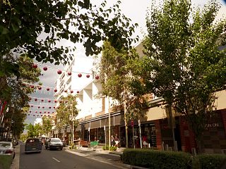
Surry Hills is an inner-east suburb of Sydney, in the state of New South Wales, Australia. Surry Hills is immediately south-east of the Sydney central business district in the local government area of the City of Sydney. Surry Hills is surrounded by the suburbs of Darlinghurst to the north, Chippendale and Haymarket to the west, Moore Park and Paddington to the east and Redfern to the south. It is often colloquially referred to as "Surry".

<span class="mw-page-title-main">Ryde, New South Wales</span> Suburb of Sydney, New South Wales, Australia

Ryde is a suburb of Sydney, New South Wales, Australia. Ryde is located 13 km north-west of the Sydney central business district and 8 km east of Parramatta. Ryde is the administrative centre of the local government area of the City of Ryde and part of the Northern Sydney region. It lies on the north bank of the Parramatta River. People from Ryde are colloquially known as Ryders, Rydiens or Rydemen.

<span class="mw-page-title-main">Hunters Hill, New South Wales</span> Suburb of Sydney, New South Wales, Australia

Hunters Hill is a suburb of Northern Sydney, in the state of New South Wales, Australia. Hunters Hill is located 9 kilometres (5.6 mi) north-west of the Sydney central business district and is the administrative centre for the local government area of the Municipality of Hunter's Hill.

<span class="mw-page-title-main">Windsor, New South Wales</span> Town in New South Wales, Australia

Windsor is a historic town in north-west of Sydney, New South Wales, Australia. It is the council seat of the Hawkesbury local government area. The town sits on the Hawkesbury River, enveloped by farmland and Australian bush. Many of the oldest surviving European buildings in Australia are located at Windsor. It is 56 km (35 mi) north-west of the Sydney CBD, on the fringes of urban sprawl. Windsor is the fourth oldest town in Australia European settlement to have European settlement. Windsor have all amenities including Shopping Malls, Supermarkets, Hospital, Schools, Service Australia, Police Station, Railway Station, Bus Depot, Hotel, Restaurants and Cafe.

<span class="mw-page-title-main">Greater Western Sydney</span> Region of the metropolitan area of Sydney, Australia

Greater Western Sydney (GWS) is a large region of the metropolitan area of Greater Sydney, New South Wales (NSW), Australia that generally embraces the north-west, south-west, central-west, far western and the Blue Mountains sub-regions within Sydney's metropolitan area and encompasses 11 local government areas: Blacktown, Blue Mountains, Camden, Campbelltown, Cumberland, Fairfield, Hawkesbury, Liverpool, Parramatta, Penrith and Wollondilly. It includes Western Sydney, which has a number of different definitions, although the one consistently used is the region composed of ten local government authorities, most of which are members of the Western Sydney Regional Organisation of Councils (WSROC). The NSW Government's Office of Western Sydney calls the region "Greater Western Sydney".

<span class="mw-page-title-main">Pyrmont, New South Wales</span> Suburb of Sydney, New South Wales, Australia

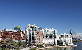
Pyrmont is an inner-city suburb of Sydney, in the state of New South Wales, Australia 2 kilometres south-west of the Sydney central business district in the local government area of the City of Sydney. It is also part of the Darling Harbour region. As of 2011, it is Australia's most densely populated suburb.

<span class="mw-page-title-main">Stanmore, New South Wales</span> Suburb of Sydney, New South Wales, Australia

Stanmore is a suburb in the Inner West of Sydney, in New South Wales, Australia 6 kilometres south west of the Sydney central business district. It is part of the local government area of the Inner West Council. It is known for its long strip of shops running along Parramatta Road.

<span class="mw-page-title-main">Burwood, New South Wales</span> Suburb of Sydney, New South Wales, Australia

Burwood is a suburb in the Inner West of Sydney, in the state of New South Wales, Australia. It is 10 kilometres (6.2 mi) west of the Sydney central business district and is the administrative centre for the local government area of Municipality of Burwood.

<span class="mw-page-title-main">Gladesville</span> Suburb of Sydney, New South Wales, Australia

Gladesville is a suburb in the Lower North Shore of Sydney, in the state of New South Wales, Australia. Gladesville is located 10 kilometres north-west of the Sydney central business district, in the local government area of the City of Ryde and the Municipality of Hunter's Hill. Gladesville is part of the federal electorates of North Sydney and Bennelong.

<span class="mw-page-title-main">Experiment Farm Cottage</span> Historic site in New South Wales, Australia

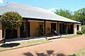
Experiment Farm Cottage is a heritage-listed former farm and residence and now house museum at 9 Ruse Street, Harris Park, City of Parramatta, Sydney, Australia. It is one of Australia's oldest standing residences, being built in c.1834. It is located at the site of Experiment Farm, Australia's first European farmstead, which was itself created by Australia's first land grant. It was added to the New South Wales State Heritage Register on 2 April 1999.

<span class="mw-page-title-main">Rouse Hill, New South Wales</span> Town in New South Wales, Australia

Rouse Hill is a town in Sydney, in the state of New South Wales, Australia. Rouse Hill is located in the Hills District, 43 kilometres north-west of the Sydney central business district and 19 kilometres north-west of the Parramatta central business district. It is in the local government areas of The Hills Shire and City of Blacktown. Rouse Hill Town Centre is at the heart of the suburb, which contains a busy Town Square.

<span class="mw-page-title-main">Rosehill, New South Wales</span> Suburb of Sydney, New South Wales, Australia

Rosehill is a suburb of Sydney, in the state of New South Wales, Australia. Rosehill is located 18 kilometres west of the Sydney central business district in the local government area of the City of Parramatta and is part of the Greater Western Sydney region.

<span class="mw-page-title-main">North Parramatta</span> Suburb of City of Parramatta, New South Wales, Australia

North Parramatta is a suburb on the North Shore of Sydney, in the state of New South Wales, Australia. North Parramatta is 24 kilometres north-west of the Sydney central business district in the local government area of the City of Parramatta.

<span class="mw-page-title-main">Lidcombe</span> Suburb of Sydney, New South Wales, Australia

Lidcombe is a suburb in western Sydney, in the state of New South Wales, Australia. Lidcombe is located 15 km (9.32 mi) west of the Sydney central business district, in the local government area of Cumberland Council, with a small industrial part in the north in the City of Parramatta. Post code: 2141, sharing it with Berala.

<span class="mw-page-title-main">Guildford, New South Wales</span> Suburb of Sydney, New South Wales, Australia

Guildford is a suburb of Sydney, in the state of New South Wales, Australia. Guildford is located 27 kilometres west of the Sydney central business district, in the local government area of Cumberland City Council. Guildford is part of the Western Sydney region. Guildford is the home of the first KFC in Australia.

<span class="mw-page-title-main">Elizabeth Farm</span> Formerly rural estate in New South Wales, Australia

Elizabeth Farm is a historic estate located at 70 Alice Street, Rosehill, a suburb of Sydney, New South Wales, Australia. Elizabeth Farm was the family home of wool pioneers John and Elizabeth Macarthur. The estate was commenced in 1793 on a slight hill overlooking the upper reaches of Parramatta River, 23 kilometres (14 mi) west of Sydney Cove. The Burramattagal clan of the Dharug people are the traditional custodians of the area; their presence is recalled in the name Parramatta.

<span class="mw-page-title-main">Annandale, New South Wales</span> Suburb of Sydney, New South Wales, Australia

Annandale is a suburb in the Inner West of Sydney, in the state of New South Wales, Australia. Annandale is located within 5 kilometres west of the Sydney central business district and is part of the local government area of the Inner West Council. Annandale's northern end lies on Rozelle Bay, which is on Sydney Harbour. Glebe lies to its east, Lilyfield and Leichhardt to its west and Stanmore and Camperdown to its south.

<span class="mw-page-title-main">Hambledon Cottage</span> Historic site in New South Wales, Australia

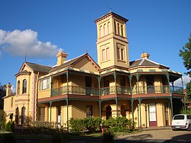
Hambledon Cottage is a heritage-listed former residence and now house museum at 47 Hassall Street, Harris Park, City of Parramatta, Sydney, New South Wales, Australia. The cottage was built from 1821 to 1825, with the initial section being designed by Henry Kitchen. It is also known as Firholme, Valley Cottage and Macarthur Cottage. The property is owned by Parramatta City Council. It was added to the New South Wales State Heritage Register on 21 September 2012.

References

  1. Australian Bureau of Statistics (28 June 2022). "Harris Park". 2021 Census QuickStats. Retrieved 25 May 2023. OOjs UI icon edit-ltr-progressive.svg
  2. Book of Sydney Suburbs, Frances Pollon (Angus and Robertson) 1990, page 120
  3. State Heritage Register
  4. The Heritage of Australia, Macmillan Company, 1981, p.2/49-50
  5. State Heritage Register
  6. The Heritage of Australia, p.2/53
  7. State Heritage Register
  8. Gregory's Sydney Street Directory, 2002, Map 308
  9. State Heritage Register
  10. "Hambledon Cottage, Grounds and Archaeology". New South Wales State Heritage Register . Department of Planning & Environment. H01888. Retrieved 18 May 2018. CC BY icon.svg Text is licensed by State of New South Wales (Department of Planning and Environment) under CC-BY 4.0 licence .
  11. "Ancient Aboriginal and Early Colonial Landscape". New South Wales State Heritage Register . Department of Planning & Environment. H01863. Retrieved 18 May 2018. CC BY icon.svg Text is licensed by State of New South Wales (Department of Planning and Environment) under CC-BY 4.0 licence .
  12. "Experiment Farm Cottage". New South Wales State Heritage Register . Department of Planning & Environment. H00768. Retrieved 18 May 2018. CC BY icon.svg Text is licensed by State of New South Wales (Department of Planning and Environment) under CC-BY 4.0 licence .
  13. "Our Lady of Lebanon Maronite Catholic Parish" . Retrieved 7 April 2021.
  14. "Church Website". Archived from the original on 6 December 2013. Retrieved 28 January 2013.
  15. 1 2 3 Australian Bureau of Statistics (27 June 2017). "Harris Park (State Suburb)". 2016 Census QuickStats. Retrieved 21 December 2017. OOjs UI icon edit-ltr-progressive.svg

33°49′29″S151°00′19″E / 33.82481°S 151.00521°E / -33.82481; 151.00521