Wentworth Point, New South Wales

Last updated

Wentworth Point
Sydney,  New South Wales
Wentworth Point Sydney.jpg
Wentworth Point from the Bennelong Bridge
Wentworth Point, New South Wales
Population12,703 (2021 census) [1]
 • Density21,200/km2 (55,000/sq mi)
Established2009
Postcode(s) 2127 [2]
Elevation5 m (16 ft)
Area0.6 km2 (0.2 sq mi)
Location12 km (7 mi) west of Sydney CBD
LGA(s) City of Parramatta
State electorate(s) Auburn
Federal division(s) Reid
Suburbs around Wentworth Point:
Melrose Park Meadowbank Rhodes
Newington Wentworth Point Concord West
Lidcombe Sydney Olympic Park Liberty Grove

Wentworth Point is a suburb of Sydney, in the state of New South Wales, Australia. It is located 13 kilometres west of the Sydney central business district, on the eastern edge of the local government area of City of Parramatta. It is on the western shore of Homebush Bay on the southern side of the Parramatta River. Wentworth Point is usually regarded as part of the Greater Western Sydney region, including in administrative contexts, [3] [4] [5] but it is also regarded as part of the Inner West region of Sydney in some contexts, especially commercial contexts. [6] [7] [8] [9]

Contents

History

This suburb was once part of the suburb of Lidcombe, known as "North Lidcombe", [10] which was renamed "Homebush Bay" between 1989 and 2009. [11] The name "Lidcombe" was first adopted in 1913 and is a portmanteau of the names of two mayors of former Rookwood Municipality, Frederick Lidbury and Henry Larcombe. [12] The name "Homebush Bay" comes from the bay with a natural and artificial shoreline on the southern side of the Parramatta River. Homebush Bay is itself named after the nearby estate of "Home Bush", established in the 1800s by the colonies assistant surgeon D'Arcy Wentworth. [13] According to local government historian Michael Jones, "Wentworth is popularly credited with having called the area after his 'home in the bush', although Homebush is also a place in Kent." [14] Wentworth Point, the point on the western extremity of the bay, and Wentworth Bay, the nearby inlet on the western shore of Homebush Bay, are named after the Wentworth family - the bay has now disappeared due to land reclamation. [15] Part of the present location of Wentworth Point was Mud Island, which became connected with the mainland due to land reclamation. [10]

In the 1860s and 1870s, the arrival of the railway led to residential development to the south of Parramatta Road, in the present-day suburbs of Homebush and Strathfield. Inspired by the successes of these nearby subdivisions, the owners of the Home Bush Estate also attempted to develop the estate by subdivision. Subdivisions in the Homebush Bay area began in 1881, when parts of the former Home Bush Estate north of Parramatta Road, extending to the tip of the peninsula which later became Wentworth Point, were subdivided as the "Homebush Park Estate". [3] In 1883, Fitzwilliam Wentworth attempted another subdivision, to be called the 'Wentworth Estate'. However, this and subsequent subdivision proposals were not successful, and other than the lots adjacent to Parramatta Road, most of the land remained unsold and was sparsely populated. [16] Parts of the area turned to industrial use, such as a new government abattoir built in 1907. [3]

Present-day Wentworth Point was part of the Borough of Rookwood proclaimed on 8 December 1891, [17] which was renamed the "Municipality of Lidcombe" in 1913. [18] The Municipality of Lidcombe merged into Auburn Council in 1948. [19] Present-day Wentworth Point was part of the suburb of Lidcombe, and part of the area known as "North Lidcombe". [10]

Industrial and commercial usage

Much of the modern suburb is reclaimed land, created by draining and filling in the northwestern shore of Homebush Bay which began in 1949. [3] The northern part of the peninsula was named Wentworth Point and gazetted in 1976. [20] After it was reclaimed from the bay, Wentworth Point was used for a variety of industrial uses.

Notable businesses include Ralph Symonds, a plywood manufacturer, which used the river as a transport route for large logs, which were then moored in Homebush Bay while awaiting processing. Other activities have included McPhee Transport depot, the former Head Office and warehouse space for Hyundai Australia and a transmission tower for Sydney radio station 2GB.

de Havilland Marine (Large Craft) was located on the waters edge at Homebush Bay. Due to a lack of new business it closed its doors in 1982. In the years prior it manufactured various large aluminium craft for both the local and international market. These included Carpentaria Class Patrol Boats for Burma & the Solomon Islands, Titan Work Boats for the New South Wales government, and the hulls of the Nepean Bell which still operates on the Nepean River in NSW.

Redevelopment and the Olympics

North Lidcombe was renamed "Homebush Bay" in 1989 and nearby parts of the peninsula began to be redeveloped in the 1990s. Prior to the move of the Royal Agricultural Society showgrounds from Moore Park to Homebush Bay (as the area of Sydney Olympic Park was then known) in 1998, much of Wentworth Point was bought by Payce Consolidated Limited. Sydney Olympic Park ferry wharf opened in 1997 at the tip of the peninsula.

Residential development

An aerial view of Wentworth Point and its surrounds 2023-06-24 Wentworth Point, NSW.jpg
An aerial view of Wentworth Point and its surrounds

Auburn Council renamed the future waterfront residential area as the suburb of Wentworth Point on 2 October 2009 [20] [21] after the council sought public comment on a proposal to rename the suburb of Homebush Bay, to remove confusion with its namesake (but not adjacent) suburb of Homebush. The area encompassing Sydney Olympic Park was given autonomy as a suburb. The Carter Street industrial precinct was absorbed by the neighbouring suburb of Lidcombe, and therefore the suburb of Homebush Bay ceased to exist.

Wentworth Point was rezoned from industrial use to residential use in 2013. As well as residential development, the plan called for cultural and commercial development in the new suburb.

Auburn Council was suspended in 2016 due to dysfunction, and later in 2016 it was abolished, with different parts of the former council area merged into different councils. Wentworth Point became part of the City of Parramatta. [22] [23] Media reports prior to the final merger decision suggested that some residents wanted Wentworth Point to instead be allocated to the City of Canada Bay. [24]

Most of Wentworth Point is now zoned for medium to high density residential development. The new Wentworth Point Public School opened in 2018. [25] Reflecting the quick increase in population, the school's enrolment has changed from 50% of capacity in 2018 to 117% in 2021. [26]

On 17 July 2023, the suburb boundary was amended to include the "Jewel Residences" and the adjacent Sydney Olympic Park ferry wharf on the northern side of Burroway Road, as well as the "Sanctuary" development area on the western side of Hill Road. [27] [28] These were previously part of Sydney Olympic Park.

Commercial areas

Wentworth Point has some small shops, cafes and restaurants.

Marina Square is a shopping centre that opened on 21 November 2018 and was built by Australian developer Billbergia. The centre has over 40 shops including a Coles supermarket. [29]

A section of the suburb, at 37-39 Hill Road, remains in active industrial use. This industrial estate stretches across the whole width of the suburb from Hill Road to the waterfront, which effectively cuts the suburb of Wentworth Point in two, with no road connection between the northern and southern sections other than by going via Hill Road in the neighbouring suburb of Sydney Olympic Park.

NSW Maritime owns about 18 hectares of land at the northern end of the point. This land has been subject to proposals for marine related development including boat storage. [30]

Population

Main street through the centre of Wentworth Point WentworthPointSydney.jpg
Main street through the centre of Wentworth Point

In the 2021 Census, there were 12,703 people in Wentworth Point, an increase of 81.6% compared to the 6,994 people counted in the 2016 Census. 34.6% of people were born in Australia. The next most common countries of birth were China 21.0%, South Korea 8.1%, India 3.8%, Iran 2.0% and Philippines 2.0%. The most common reported ancestries were Chinese 31.6%, English 11.9%, Korean 10.5%, Australian 9.2% and Indian 4.9%. 32.1% of people only spoke English at home. Other languages spoken at home included Mandarin 23.0%, Korean 9.8%, Cantonese 5.1%, Arabic 3.5% and Persian 2.0%. The most common responses for religion were No Religion 46.9%, Catholic 15.1%, Islam 7.0%, Not stated 6.0% and Buddhism 4.5%. Median weekly household income was $2,035, higher than the New South Wales median of $1,829. [1]

Recreation

Cycle paths extend through Sydney Olympic Parklands used by cyclists, runners and walkers. The Bennelong Bridge creates a bay run or cycle loop around Homebush Bay. A shorter 6 kilometre loop through Bicentennial Park or a longer 12 kilometre loop through to Silverwater Bridge are available.

Kayaking, rowing and dragon boating can be seen inside Homebush Bay, but water access and boat storage facilities are limited. There is a recreation club in Wentworth Point which has an indoor heated pool, an outdoor recreational pool, gym and tennis courts. A wide range of other recreation facilities are available at nearby Sydney Olympic Park.

Transport

Bennelong Bridge serves as a pedestrian and bus only connection to Rhodes station Bennelong Bridge bus lane signage.jpg
Bennelong Bridge serves as a pedestrian and bus only connection to Rhodes station

Wentworth Point is served by bus. The 526 bus services Wentworth Point from Burwood to Rhodes in both directions. The 533 bus services Wentworth Point from Chatswood to Olympic Park in both directions. An additional local shuttle bus started on 22 May 2016. [31] [32]

Sydney Olympic Park ferry wharf is at the northern end of Wentworth Point. The wharf is served by Parramatta River ferry services. Regular services run to Circular Quay, Darling Harbour and Parramatta. The wharf was upgraded to have two docks and faster transitions in 2015.

Until 2016, Wentworth Point was relatively isolated by road. Because it is surrounded by parklands in the west and south and by water in the north and east, it was only accessible by road from the rest of Sydney by two roads, Hill Road which connected it to Lidcombe, and Bennelong Parkway, which connected it to Sydney Olympic Park and the A3 arterial road. Moreover, the northern and southern sections of Wentworth Point are not accessible to each other, except by going via Hill Road in neighbouring Sydney Olympic Park. Road access to the northern section was improved when the 300-metre (984 ft) Bennelong Bridge across Homebush Bay opened in May 2016, making it easier for residents to access shops and the railway station at Rhodes. [33] [34] However, the bridge roadway can only be used by buses and emergency service vehicles. The bridge also includes a pathway for cyclists and pedestrians.

There are no train services to Wentworth Point; the closest stations are Rhodes and Olympic Park.

Stage 2 of the Parramatta Light Rail is a proposed light rail link between Westmead and Sydney Olympic Park via Parramatta, and would pass adjacent to the suburb on the western side. The project would include the construction of a bridge across the Parramatta River, between Sydney Olympic Park and Melrose Park. [35] [36]

Related Research Articles

<span class="mw-page-title-main">Rhodes, New South Wales</span> Suburb of Sydney, New South Wales, Australia

Rhodes is an Inner West suburb of Sydney, in the state of New South Wales, Australia. Rhodes is located 12 kilometres west of the Sydney central business district, in the local government area of the City of Canada Bay. It was formerly part of Concord Municipality until a merger with Drummoyne Council to form Canada Bay in December 2000.

<span class="mw-page-title-main">Parramatta River</span> River in Australia

The Parramatta River is an intermediate tide-dominated, drowned valley estuary located in Sydney, New South Wales, Australia. With an average depth of 5.1 metres (17 ft), the Parramatta River is the main tributary of Sydney Harbour, a branch of Port Jackson. Secondary tributaries include the smaller Lane Cove and Duck rivers.

<span class="mw-page-title-main">Homebush Bay</span> Suburb of Sydney, New South Wales, Australia

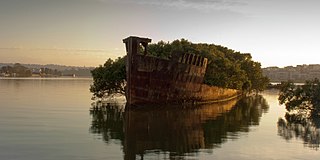
Homebush Bay is a bay on the south bank of the Parramatta River, in the west of Sydney, Australia. The name is also sometimes used to refer to an area to the west and south of the bay itself, which was formerly an official suburb of Sydney, and has now become the suburbs of Sydney Olympic Park, Wentworth Point and part of the neighbouring suburb of Lidcombe, all part of the City of Parramatta. Homebush Bay is located 13 kilometres (8.1 mi) west of the Sydney central business district.

<span class="mw-page-title-main">Homebush, New South Wales</span> Suburb of Sydney, New South Wales, Australia

Homebush is a suburb in the Inner West of Sydney in the state of New South Wales, Australia. It is located 12 kilometres west of the Sydney central business district, in the local government area of the Municipality of Strathfield.

<span class="mw-page-title-main">Municipality of Strathfield</span> Local government area in New South Wales, Australia

The Municipality of Strathfield is a local government area in the Inner West of Sydney, in the state of New South Wales, Australia.

<span class="mw-page-title-main">Inner West</span> Region in New South Wales, Australia

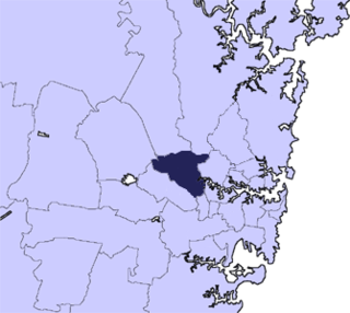
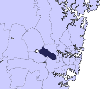
The Inner West of Sydney is an area directly west of the Sydney central business district, New South Wales, Australia. The suburbs that make up the Inner West are predominantly located along the southern shore of Port Jackson, stretching south to the shores of the Cooks River. The western boundary of the Inner West is approximately the A3 arterial road, which divides the Inner West from the Greater Western Sydney region. The Inner West is much larger than the Inner West Council local government area. The Inner West roughly corresponds with the Parish of Petersham and Parish of Concord, two cadastral divisions used for land titles.

<span class="mw-page-title-main">Auburn, New South Wales</span> Suburb of Cumberland City Council, New South Wales, Australia

Auburn is a Western Sydney suburb in the state of New South Wales, Australia. Auburn is located 16 kilometres (9.9 mi) west of the Sydney central business district and is in the local government area of Cumberland City Council, having previously been the administrative centre of Auburn Council. The suburb was named after Oliver Goldsmith's poem The Deserted Village, which describes 'Auburn' in England as the "loveliest village of the plain".

<span class="mw-page-title-main">Newington, New South Wales</span> Suburb of Sydney, New South Wales, Australia

Newington is a western suburb of Sydney, in the state of New South Wales, Australia. It is 16 kilometres west of the Sydney central business district, in the local government area of City of Parramatta.

<span class="mw-page-title-main">City of Parramatta</span> Local government area in New South Wales, Australia

The City of Parramatta, also known as Parramatta Council, is a local government area located to the west and north-west of Sydney CBD in the Greater Western Sydney region. Parramatta Council is situated between the City of Ryde and Cumberland, where the Cumberland Plain meets the Hornsby Plateau, approximately 25 kilometres (16 mi) west of the Sydney central business district, in New South Wales, Australia. The city occupies an area of 84 square kilometres (32 sq mi) spanning across suburbs in Greater Western Sydney including the Hills District, and a small section of Northern Sydney to the far north east of its area. According to the 2016 census, City of Parramatta had an estimated population of 226,149. The city houses the Parramatta central business district which is one of the key suburban employment destinations for the region of Greater Western Sydney.

<span class="mw-page-title-main">Putney, New South Wales</span> Suburb of Sydney, New South Wales, Australia

Putney is a suburb of Northern Sydney, New South Wales, Australia. It is located 14 kilometres (9 mi) north-west of the Sydney central business district on the northern bank of the Parramatta River. Its local government area is the City of Ryde.

<span class="mw-page-title-main">Meadowbank, New South Wales</span> Suburb of Sydney, New South Wales, Australia

Meadowbank is a suburb of Sydney, New South Wales, Australia, 15 kilometres north west of the Sydney central business district, in the local government area of the City of Ryde and part of the Northern Sydney region. Meadowbank sits in a valley on the northern bank of the Parramatta River.

<span class="mw-page-title-main">Lidcombe</span> Suburb of Sydney, New South Wales, Australia

Lidcombe is a suburb in western Sydney, in the state of New South Wales, Australia. Lidcombe is located 15 km (9.32 mi) west of the Sydney central business district, in the local government area of Cumberland Council, with a small industrial part in the north in the City of Parramatta. Post code: 2141, sharing it with Berala.

<span class="mw-page-title-main">Drummoyne</span> Suburb of Sydney, New South Wales, Australia

Drummoyne is a suburb in the Inner West of Sydney, in the state of New South Wales, Australia. Drummoyne is six kilometres west of the Sydney central business district and is the administrative centre for the local government area of the City of Canada Bay.

<span class="mw-page-title-main">Ermington, New South Wales</span> Suburb of Sydney, New South Wales, Australia

Ermington is a suburb of Sydney, New South Wales, Australia. Ermington is located 19 kilometres West of the Sydney central business district, in the local government area of the City of Parramatta. Ermington lies on the northern bank of the Parramatta River.

<span class="mw-page-title-main">Flemington, New South Wales</span> Suburb of Sydney, New South Wales, Australia

Flemington, officially gazetted as "Homebush West" since 1992, is a suburb in the Inner West of Sydney, in the state of New South Wales, Australia. Flemington is located 13 kilometres west of the Sydney central business district, in the local government area of the Municipality of Strathfield, with a small unpopulated area in Cumberland Council.

<span class="mw-page-title-main">Sydney Olympic Park</span> Suburb of Sydney, New South Wales, Australia

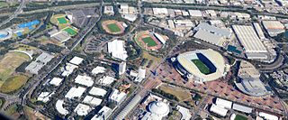
Sydney Olympic Park is a suburb of Greater Western Sydney, located 13 kilometres west of the Sydney central business district, in the local government area of the City of Parramatta Council. It is commonly known as Olympic Park but officially named Sydney Olympic Park. The area was part of the suburb of Lidcombe and known as "North Lidcombe", but between 1989 and 2009 was named "Homebush Bay". The names "Homebush Bay" and, sometimes, "Homebush" are still used colloquially as a metonym for Stadium Australia as well as the Olympic Park precinct as a whole, but Homebush is an older, separate suburb to the southeast, in the Municipality of Strathfield.

<span class="mw-page-title-main">Parramatta River ferry services</span>

Parramatta River ferry services connect suburbs along the Parramatta River in Sydney with Circular Quay by commuter ferry. The services are numbered F3 and form part of the Sydney Ferries network.

<span class="mw-page-title-main">Haslams Creek</span> River in Australia

Haslams Creek, a southern tributary of the Parramatta River, is a creek west of Sydney Harbour, located in Sydney, Australia. It flows through Sydney Olympic Park and joins Parramatta River at Homebush Bay. In 1793, the first grants were made to free settlers, with Samuel Haslam receiving his first grant in 1806. A 50 acre grant north of Parramatta Road, the first grant, was followed by a second small grant south of Parramatta Road and east of Haslams Creek. Haslams Creek flowed through the holdings of the Sydney Meat Preserving Company Ltd 1876-1965, which at one point damned the creek. When opened, Lidcombe railway station actually bore the name Haslams Creek Station

<span class="mw-page-title-main">Bennelong Bridge</span> Bridge in New South Wales, Australia

The Bennelong Bridge is a 330-metre-long (1,080 ft) vehicular bridge across Homebush Bay between the Sydney suburbs of Rhodes and Wentworth Point. Construction started on 1 September 2014. It opened on 22 May 2016.

<span class="mw-page-title-main">Cumberland City Council</span> Local government area in New South Wales, Australia

Cumberland Council, trading as Cumberland City Council, is a local government area located in the western suburbs of Sydney in the state of New South Wales, Australia. The Council was formed on 12 May 2016 from the merger of parts of the Cities of Auburn, Parramatta, and Holroyd.

References

  1. 1 2 Australian Bureau of Statistics (28 June 2022). "Wentworth Point (State Suburb)". 2021 Census QuickStats. Retrieved 28 June 2022. OOjs UI icon edit-ltr-progressive.svg
  2. Wentworth Point Postcode Australia Post
  3. 1 2 3 4 City of Parramatta - Wentworth Point - A Brief History
  4. Centre for Western Sydney - About the profile area
  5. "Six selected in design competition for 1,000 new homes in western Sydney", Architecture AU
  6. Domain - Wentworth Point Suburb Profile
  7. About Reid NSW Liberal Party
  8. Wentworth Point PropertyNest
  9. Murder charge after man was allegedly mowed down and crushed by a car in Sydney’s inner west The Australian 29 June 2020
  10. 1 2 3 Dictionary of Sydney - Homebush Bay
  11. "Wentworth Point". Geographical Names Register (GNR) of NSW. Geographical Names Board of New South Wales. OOjs UI icon edit-ltr-progressive.svg
  12. ""Lidcombe" or Rockwood". The Cumberland Argus and Fruitgrowers' Advocate. Vol. XXVI, no. 2038. New South Wales. 12 July 1913. p. 12. Retrieved 2 December 2017 via National Library of Australia.
  13. Pollon, Frances, ed. (1990). The Book of Sydney Suburbs'. Australia: Angus & Robertson Publishers. p. 124. ISBN   0-207-14495-8.
  14. Jones, Michael (1985). Oasis in the West: Strathfield's first hundred years. North Sydney: Allen & Unwin Australia. p. 15. ISBN   0-86861-407-6.
  15. Dictionary of Sydney - Wentworth Bay
  16. Site 2 – Sydney Olympic Park: Historical Archaeological Assessment and Statement of Heritage Impact
  17. "Government Gazette Proclamations and Legislation". New South Wales Government Gazette. No. 782. New South Wales, Australia. 10 December 1891. p. 9683. Retrieved 14 November 2017 via National Library of Australia.
  18. "PROCLAMATION". Government Gazette of the State of New South Wales. No. 167. 22 October 1913. p. 6335. Retrieved 17 November 2017 via National Library of Australia.
  19. "4895 Royal Commission on Local Government Boundaries". State Records Archives Investigator. State Archives and Records Authority of New South Wales. Retrieved 2 November 2017.
  20. 1 2 "Wentworth Point". Geographical Names Register (GNR) of NSW. Geographical Names Board of New South Wales. OOjs UI icon edit-ltr-progressive.svg
  21. New names for Auburn Suburbs Auburn City Council
  22. Saulwick, Jacob; Kembrey, Melanie; McKenny, Leisha (14 May 2016). "NSW council amalgamations announced". The Sydney Morning Herald. Retrieved 25 August 2016.
  23. "Local Government (City of Parramatta and Cumberland) Proclamation 2016 [NSW]". NSW Government. 12 May 2016. Retrieved 14 November 2017.
  24. "Wentworth Point residents want to leave Auburn City Council, Greater Parramatta for Canada Bay council", Daily Telegraph 17 February 2016
  25. "Brand new school for Wentworth Point" (Press release). Government of New South Wales . Retrieved 6 November 2018.
  26. Revealed: The Sydney schools running out of space, 4 January 2022, Sydney Morning Herald
  27. "Sydney Olympic Park Boundary Amendment". City of Parramatta - Participate Parramatta. Retrieved 18 August 2023.
  28. "Finalisation of Suburb Amendment between Sydney Olympic Park and Wentworth Point". City of Parramatta. 13 July 2023. Retrieved 18 August 2023.
  29. "Marina Square | Wentworth Point Shopping and Restaurants". marinasquare.com.au. Retrieved 23 October 2018.
  30. "Department of Planning and Environment - Wentworth Point". planning.nsw.gov.au. Retrieved 27 February 2016.
  31. Bennelong Bridge was officially opened 22 May 2016 Bennelong Bridge connecting committee
  32. "The Planning Process". homebushbaybridge.com.au. Bennelong Bridge connecting committee. Retrieved 27 February 2016.
  33. "About the Bridge". homebushbaybridge.com.au. Bennelong Bridge connecting committee. Retrieved 27 February 2016.
  34. A Bridge to Belonging Billbergia 3 September 2013
  35. "Parramatta Light Rail to Sydney Olympic Park". Transport for NSW. 18 October 2017. Retrieved 18 October 2017.
  36. Constance, Andrew. "We're planning light rail extension to Sydney Olympic Park to improve public transport for 1000's[sic] of event goers". Twitter. Retrieved 19 October 2017.

33°49′35″S151°4′41″E / 33.82639°S 151.07806°E / -33.82639; 151.07806