The Parramatta River is an intermediate tide-dominated, drowned valley estuary located in Sydney, New South Wales, Australia. With an average depth of 5.1 metres (17 ft), the Parramatta River is the main tributary of Sydney Harbour, a branch of Port Jackson. Secondary tributaries include the smaller Lane Cove and Duck rivers.

Carlingford is a suburb of Sydney, in the state of New South Wales, Australia. Carlingford is 22 kilometres north-west of the Sydney central business district in the local government area of City of Parramatta. Carlingford is in the Hills District and Northern Sydney regions.
Dundas is a suburb of Sydney, New South Wales, Australia. Dundas is located 21 kilometres north-west of the Sydney central business district, in the local government area of the City of Parramatta, and the electoral division of Bennelong. Dundas is a leafy green suburb, notably due to its centrepiece The Ponds Walk, which follows the Ponds Subiaco Creek. Dundas is part of the Northern Sydney and Greater Western Sydney regions.

Rydalmere(formerly "Field of Mars") is a suburb of Sydney, in the state of New South Wales, Australia. Rydalmere is approximately 21 kilometres west of the Sydney central business district in the local government area of the City of Parramatta. Rydalmere is part of the Greater Western Sydney region.

The Division of Parramatta is an Australian electoral division in the state of New South Wales. The division was created in 1900 and was one of the original 65 divisions contested at the first federal election. It is named for the locality of Parramatta. The name Parramatta has been sourced to an Aboriginal word for the area. The Darug people had lived in the area for many generations, and regarded the area as a food bowl, rich in food from the river and forests. They called the area Baramada or Burramatta ('Parramatta') which means "the place where the eels lie down".
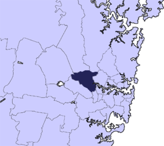
The City of Parramatta Council is a local government area located west of central Sydney in the Greater Western Sydney region. Parramatta Council is situated between the City of Ryde and Cumberland, where the Cumberland Plain meets the Hornsby Plateau, approximately 25 kilometres (16 mi) west of the Sydney central business district, in the state of New South Wales, Australia.

Telopea is a suburb of Greater Western Sydney, in the state of New South Wales, Australia. Telopea is located 23 kilometres north-west of the Sydney central business district, in the local government area of the City of Parramatta. The suburb is bordered by Kissing Point Road to the south and Pennant Hills Road to the north.

Camellia is a post industrial suburb of Sydney, in the state of New South Wales, Australia. It began brownfields remediation in late 2015, and is ear-marked as a major centre for high density living.

Dundas Valley is a suburb of Sydney, in the state of New South Wales, Australia. Dundas Valley is located 21 kilometres north-west of the Sydney central business district in the local government area of the City of Parramatta. Dundas Valley is part of the Northern Sydney and Greater Western Sydney regions.

Ermington(formerly "Field of Mars") is a suburb of Sydney, New South Wales, Australia. Ermington is located 19 kilometres north-west of the Sydney central business district, in the local government area of the City of Parramatta. Ermington lies on the northern bank of the Parramatta River.

Parramatta is an electoral district of the Legislative Assembly in the Australian state of New South Wales. It is currently held by Geoff Lee of the Liberal Party.

Cumberland High School is a co-educational comprehensive secondary school located in the north-western metropolitan Western Sydney region of New South Wales, Australia.
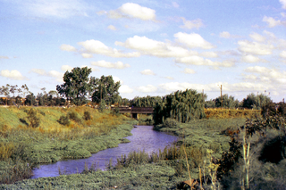
The Duck River is a perennial stream and southern tributary of the Parramatta River, in Sydney, New South Wales, Australia.
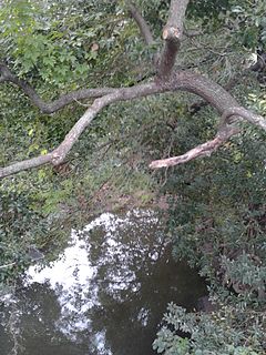
Vineyard Creek, a northern tributary of the Parramatta River, is a creek west of Sydney Harbour, located in Sydney, Australia.

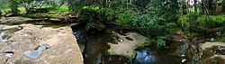
The Darling Mills Creek, an urban watercourse that is part of the Parramatta River catchment, is located in Greater Western Sydney, New South Wales, Australia.

The Carlingford railway line was a railway line in Sydney, Australia. It was opened from Clyde to Subiaco in January 1885, then by means of the construction of a bridge across the Parramatta River, to Carlingford in April 1896. It closed on 5 January 2020 with much of the line to be converted to light rail as part of the Parramatta Light Rail network, while a short section of the line was retained for use by Sydney Trains.

The Parramatta Light Rail is a project for a twelve-kilometre (seven-mile) light rail line in Sydney, New South Wales, Australia, which is currently under construction. The line will run from Westmead to Carlingford via the Western Sydney centre of Parramatta. The initial announcement of the project also included an eastern branch from Camellia to Strathfield. Plans to construct this branch were deferred in February 2017, and in October the original plans were replaced with a redesigned and truncated route to Sydney Olympic Park. The project will add to light rail in Sydney but the new line will be completely separated from the existing lines. It is being managed by Transport for NSW.
The Parramatta Valley cycleway is a 15-kilometre-long (9.3 mi) shared use path for cyclists and pedestrians that is generally aligned with the Parramatta River in Sydney, New South Wales, Australia. The eastern terminus of the cycleway is at Morrison Bay Park in Ryde and heads west along dedicated bike paths, quiet streets and the river foreshore to its western terminus in the Parramatta Park in Parramatta.
The Municipality of Ermington and Rydalmere was a local government area in the Western region of Sydney, New South Wales, Australia. Initially proclaimed as the southern part of the Borough of Dundas in 1889, following a petition of secession the municipality was proclaimed as the Municipal District of Ermington and Rydalmere on 18 June 1891. It included the modern suburbs of Rydalmere and parts of Dundas, Ermington and Melrose Park. From 1 January 1949, the council was amalgamated into the City of Parramatta, with the passing of the Local Government (Areas) Act 1948.
The Municipality of Dundas was a local government area in the North-western region of Sydney, New South Wales, Australia. Initially proclaimed as the "Borough of Dundas" on 23 March 1889, the southern part of the municipality seceded in June 1891 as the Municipal District of Ermington and Rydalmere. From 1891, the municipality included the modern suburbs of Dundas, Dundas Valley and parts of Ermington, Epping, Eastwood, Melrose Park, Oatlands and Carlingford. From 1 January 1949, the council was amalgamated into the City of Parramatta, with the passing of the Local Government (Areas) Act 1948.