Meadowbank, New South Wales

Last updated

Meadowbank
Sydney,  New South Wales
Meadowbank railway shops and outdoor eating area.jpg
Meadowbank railway shops and outdoor eating area
Meadowbank, New South Wales
Map
Population5,089 (2021 census) [1]
 • Density7,300/km2 (18,800/sq mi)
Established1801
Postcode(s) 2114
Elevation20 m (66 ft)
Area0.7 km2 (0.3 sq mi)
Location15 km (9 mi) north-west of Sydney CBD
LGA(s) City of Ryde
State electorate(s) Ryde
Federal division(s) Bennelong
Suburbs around Meadowbank:
Denistone West Ryde Ryde
Melrose Park Meadowbank Putney
Homebush Bay Rhodes Breakfast Point

Meadowbank is a suburb of Sydney, New South Wales, Australia, 15 kilometres north west of the Sydney central business district, in the local government area of the City of Ryde and part of the Northern Sydney region. Meadowbank sits in a valley on the northern bank of the Parramatta River.

Contents

History

Aboriginal culture

The territory from Sydney Cove to Parramatta, on the northern side of the Parramatta River, was thought to be that of the Wallumattagal, and had the aboriginal name Wallumetta, the territory of the Wallumede people.

Aboriginal people in the Sydney district were clans of larger groups sharing a common language. Three language groups have been identified in the Sydney Region – the Kuringgai (or Guringai), the Dharug (or Dharruk / Dharuk / Darug), and the Dharawal (or Tharawal). The Wallumedegal are thought to have been within the Dharug speaking area. [2]

European settlement

Meadowbank Railway Bridge John Witton Bridge11.jpg
Meadowbank Railway Bridge

Land originally granted to Surgeon William Balmain in 1794, in the district of the Field of Mars, was bestowed the name 'Meadow Bank'. Balmain returned to England in 1801, leaving his estates to be managed by fellow surgeon D'Arcy Wentworth. Wentworth agreed to sell Balmain's grants to John Bennett, an ex-convict who had been transported in 1795. By 1819 both the 'Meadow Bank Estate' and 'Chatham Farm' to the north, belonged to Bennett. In 1823 he was joined by his nephew William Bennett. John Bennett died in July 1829, a bachelor, and his nephew inherited his estate, building Meadowbank House around 1835. William then sold 'Chatham Farm' to Major Edward Darvall in 1855. William Bennett died in 1865 but his widow remained at Meadowbank until her death in 1879. The estate was subdivided in the late 1880s, given impetus by the opening of the Main Northern railway line from Strathfield to Hornsby in 1886. Meadowbank station opened as Hellenic, later being renamed Meadowbank, after the Meadowbank Estate. [2] Meadowbank Public Baths established in 1895 was a former recreation destination but were closed in 1943 due to pollution from Homebush Bay. [3] Shepherds Bay Row Boat ferry services were established as early as 1794 from Schooner Wharf (Belmore Road, near Helene Park) taking passengers to the Concord shore.

Meadowbank Manufacturing Company workshops 1922 Meadowbank Manufacturing Company workshops 1922.jpg
Meadowbank Manufacturing Company workshops 1922

Meadowbank Manufacturing Company Works was the first industry in Meadowbank, established on 95 acres of land in 1890, with frontage to the Parramatta River and easy access to the railway producing agricultural equipment for the local area and throughout the country. The existing seawall is made from the remnants of the original sandstone. Shepherds Bay is named after early settler James Shepherd, transported as a convict in 1791. Vineyard terraces were located on the upper slopes. Former Ryde Wharf and punt located in Shepherds Bay Park. Remnants of wharf walling visible at low tide. The Ryde to Rhodes punt operated between 1898 and 1935. Passengers included employees of the State Timber yards at Rhodes and cattle. The punt was unreliable; "the cable continually gave way and cargoes of cattle went sailing downstream".

Ryde Council investigated potential sites for the Ryde Baths in 1877 and the desirability of having public baths. Ten years later, when a man was killed whilst bathing at Ryde Wharf, the issue was raised again. In 1904, a site was chosen at the bottom of Waterview Road. The Ryde Swimming Baths were opened in 1905. Mixed bathing was not permitted. Ryde Bridge took two years to build, and opened in 1935. A series of tolls were applied and were ceased to be collected in 1949. State Timber Yards were opposite on Rhodes Peninsula. [3]

Heritage listings

Meadowbank has a number of heritage-listed sites, including:

Commercial area

Meadowbank is a mixed commercial-residential area. Meadowbank features a small group of shops on either side of Meadowbank railway station and a shopping centre within the residential apartment complex to the south, along Bay Drive.

Meadowbank has waterfront high-rise apartments with views of the Parramatta River, and cafés and restaurants along the water's edge. [5]

Meadowbank TAFE is situated on the east side of the station. It is one of the largest TAFE NSW colleges in Sydney. [6]

Transport

Meadowbank railway station Meadowbank station.jpg
Meadowbank railway station

Meadowbank is easily accessible by Road, Ferry, Bus and Train. Meadowbank experiences limited traffic as major roads circle rather than run through the suburb. Lane Cove Road to the east, Victoria Road to the north and Adelaide Street to the West. Other central roads include Constitution Road, Meadow Crescent and Bank Street.

Meadowbank railway station is on the Main Northern railway line. Meadowbank has two side platforms. The station is served by four trains per hour each way, with additional trains on weekday peak hours. The station is within walking distance of Meadowbank ferry wharf served by Sydney to Parramatta ferries.

Meadowbank has a ferry wharf on the Parramatta River as part of the Sydney Ferries network. The next wharf west is Sydney Olympic Park and east is Kissing Point. The ferry primarily services tourists on weekends and city workers during the week.

Landmarks and features

Apartments along the Meadowbank waterfront Meadowbank Sydney.jpg
Apartments along the Meadowbank waterfront
Rothesay Avenue Meadowbank Sydney2.jpg
Rothesay Avenue

Schools

Churches

Parks

Meadowbank features great public access to Parramatta River and surrounding parklands.

Waterways

Scout halls

Demographics

In the 2021 Australian Bureau of Statistics Census of Population and Housing, the population of Meadowbank was 5,089 people. The population was 49.2% male, 50.8% female. 37.4% of people were born in Australia. The most common countries of birth were China 11.7%, South Korea 7.8%, India 6.1%, Philippines 3.7% and Hong Kong 2.8%. 38.2% of people only spoke English at home. Other languages spoken at home included Mandarin 13.2%, Korean 9.4%, Cantonese 6.4%, Hindi 2.3% and Nepali 2.2%. The most common responses for religion were No Religion 40.9%, Catholic 17.0%, Hinduism 8.1, 5.2% of residents did not state their religion, and 5.1% of residents followed Buddhism. [1]

96.8% of occupied private dwellings in Meadowbank were flats or apartments. [1]

Politics

State Election [14]
  Labor 39.30%
  Greens 14.65%
  Liberal 41.77%
 Informed Medical Operations Party1.54%
  Sustainable Australia Party 2.72%
Federal Election [15]
  Labor 32.43% (51.35%)
  Liberal 41.25% (48.65%)
  Greens 17.64%
  United Australia Party 2.99%
  FUSION 2.42%

The Federal member for Bennelong is Jerome Laxale and the current State member for Ryde is Jordan Lane. The Mayor of the local Ryde City Council is Sarkis Yedelian. The table contains first-preference votes for each candidate at a state and federal level with the Meadowbank polling place results for each column. Two party preferred results are also shown in brackets for the federal election.

Related Research Articles

<span class="mw-page-title-main">Rhodes, New South Wales</span> Suburb of Sydney, New South Wales, Australia

Rhodes is an Inner West suburb of Sydney, in the state of New South Wales, Australia. Rhodes is located 12 kilometres west of the Sydney central business district, in the local government area of the City of Canada Bay. It was formerly part of Concord Municipality until a merger with Drummoyne Council to form Canada Bay in December 2000.

<span class="mw-page-title-main">Parramatta River</span> River in Australia

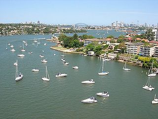
The Parramatta River is an intermediate tide-dominated, drowned valley estuary located in Sydney, New South Wales, Australia. With an average depth of 5.1 metres (17 ft), the Parramatta River is the main tributary of Sydney Harbour, a branch of Port Jackson. Secondary tributaries include the smaller Lane Cove and Duck rivers.

<span class="mw-page-title-main">Town Hall railway station, Sydney</span> Heritage-listed railway station in Sydney, New South Wales, Australia

Town Hall railway station is a heritage-listed underground commuter rail station located in the centre of the Sydney central business district in New South Wales, Australia. The station opened on 28 February 1932. It is named after the Sydney Town Hall, located directly above the station.

<span class="mw-page-title-main">Ryde, New South Wales</span> Suburb of Sydney, New South Wales, Australia

Ryde is a suburb of Sydney, New South Wales, Australia. Ryde is located 13 km north-west of the Sydney central business district and 8 km east of Parramatta. Ryde is the administrative centre of the local government area of the City of Ryde and part of the Northern Sydney region. It lies on the north bank of the Parramatta River. People from Ryde are colloquially known as Ryders, Rydiens or Rydemen.

<span class="mw-page-title-main">North Epping, New South Wales</span> Suburb of Sydney, New South Wales, Australia

North Epping is a suburb of Sydney, in the state of New South Wales, Australia 19 kilometres north-west of the Sydney central business district in the local government area of Hornsby Shire. North Epping is in the Northern Sydney region, and is often referred to as part of the "North-West" or North Shore. Epping is a separate suburb to the south and under the Parramatta City Council, which shares the postcode of 2121.

<span class="mw-page-title-main">Meadowbank railway station, Sydney</span> Railway station in Sydney, New South Wales, Australia

Meadowbank railway station is located on the Main Northern line, serving the Sydney suburb of Meadowbank. It is served by Sydney Trains T9 Northern Line services.

<span class="mw-page-title-main">Ryde Bridge</span> Bridges across the Parramatta River in Sydney, Australia

The Ryde Bridge, also called the Uhrs Point Bridge, are two road bridges that carry Concord Road, part of the A3, across Parramatta River from Ryde in the northern suburbs of Sydney to Rhodes in Sydney's inner west, in New South Wales, Australia.

<span class="mw-page-title-main">West Ryde, New South Wales</span> Suburb of Sydney, New South Wales, Australia

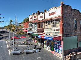
West Ryde is a suburb of Sydney, in the state of New South Wales, Australia. West Ryde is located 16 kilometres north-west of the Sydney central business district, in the local government area of the City of Ryde and is part of the Northern Sydney region.

<span class="mw-page-title-main">Putney, New South Wales</span> Suburb of Sydney, New South Wales, Australia

Putney is a suburb of Northern Sydney, New South Wales, Australia. It is located 14 kilometres (9 mi) north-west of the Sydney central business district on the northern bank of the Parramatta River. Its local government area is the City of Ryde.

<span class="mw-page-title-main">Melrose Park, New South Wales</span> Suburb of Sydney, New South Wales, Australia

Melrose Park is a suburb of Sydney, New South Wales, Australia, located 12 kilometres north-west of the Sydney central business district. Melrose Park is split between the local government areas of the City of Ryde and the City of Parramatta. It is part of the Northern Sydney region. Melrose Park sits on the northern bank of the Parramatta River. The Melrose Park Residents Action Group (MPRAG) and Waterfront Action (WAG) NSW Inc groups represents the community on local and waterfront issues.

<span class="mw-page-title-main">Meadowbank ferry wharf</span>

Meadowbank ferry wharf is located on the northern side of the Parramatta River serving the Sydney suburb of Meadowbank.

<span class="mw-page-title-main">Balmain East ferry wharf</span>

Balmain East ferry wharf is located on Sydney Harbour serving the Sydney suburb of Balmain East.

<span class="mw-page-title-main">Sydney Olympic Park ferry wharf</span>

Sydney Olympic Park ferry wharf is located on the southern side of the Parramatta River serving the Sydney suburb of Wentworth Point.

<span class="mw-page-title-main">Parramatta River ferry services</span>

Parramatta River ferry services connect suburbs along the Parramatta River in Sydney with Circular Quay by commuter ferry. The services are numbered F3 and form part of the Sydney Ferries network.

<span class="mw-page-title-main">Parramatta ferry wharf</span>

Parramatta ferry wharf is located near the source of the Parramatta River, serving the Sydney satellite city of Parramatta.

<span class="mw-page-title-main">Northern Sydney</span> Region of Sydney in New South Wales, Australia

Northern Sydney is a large metropolitan area in Greater Sydney, New South Wales, Australia on the north shore of Sydney Harbour and Parramatta River. The region embraces suburbs in Sydney's north-east, north and inner north west. Northern Sydney is divided into distinctive regions such as the North Shore, Northern Beaches and Forest District.

<span class="mw-page-title-main">Bayview Park ferry wharf</span> Commuter wharf in Sydney, New South Wales, and site of a historic Canadian patriote convict landing

Bayview Park ferry wharf is a commuter wharf located in the Sydney suburb of Concord, New South Wales, on Hen & Chicken Bay. It is situated adjacent the namesake Bayview Park reserve, and upon the site of the historical Burwood ferry wharf, where Canadian exiles from the 19th century Lower Canada Rebellion landed in Sydney. Bayview Park was originally serviced by a Matilda Cruises route, before being included on Sydney Ferries' Parramatta River service in 2006, after a brief one-year service by Palm Beach Ferries. Services to the wharf were decommissioned by Sydney Ferries in October 2013, alongside Balmain West after patronage declined to a weekly average of 28 passengers. No operators currently service the wharf, although the structure still remains, with plans to return private ferry services to the wharf as part of a redevelopment project for a factory in eastern Concord.

<span class="mw-page-title-main">Bike paths in Sydney</span> Bike paths

Bike paths in Sydney, New South Wales, Australia, vary widely, with the majority either shared cycle and pedestrian paths or on road paths, and a small number of separated cycleways. In 2009 the Sydney Morning Herald reported that "Sydney's cycleways are not so much an organised network as a fragmented collection of winding paths and half-finished ideas. Most were built or designed when cycling was viewed as a pleasant pastime rather than a practical form of travel and are now poorly suited to commuting."

Charity Creek, a northern tributary of the Parramatta River, is a creek west of Sydney Harbour, located in Sydney, New South Wales, Australia. It joins the Parramatta River at Meadowbank Park, Meadowbank.

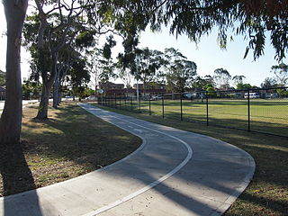
The Parramatta Valley cycleway is a 15-kilometre-long (9.3 mi) shared-use path for cyclists and pedestrians that is generally aligned with the Parramatta River in Sydney, New South Wales, Australia. The eastern terminus of the cycleway is at Morrison Bay Park in Ryde and heads west along dedicated bike paths, quiet streets and the river foreshore to its western terminus at Parramatta Park in Parramatta.

References

  1. 1 2 3 Australian Bureau of Statistics (28 June 2022). "Meadowbank". 2021 Census QuickStats. Retrieved 3 February 2024. OOjs UI icon edit-ltr-progressive.svg
  2. 1 2 "A Brief History of Ryde". City of Ryde. Archived from the original on 13 June 2008. Retrieved 20 September 2008.
  3. 1 2 Ryde River Walk Masterplan Archived 6 July 2011 at the Wayback Machine at Ryde City Council
  4. "Meadowbank Rail Bridge over Parramatta River". New South Wales State Heritage Register . Department of Planning & Environment. H01189. Retrieved 18 May 2018. CC BY icon.svg Text is licensed by State of New South Wales (Department of Planning and Environment) under CC-BY 4.0 licence .
  5. "10 Most Underrated Sydney Suburbs". Sydney Suburb Reviews. 29 November 2019. Retrieved 8 September 2023.
  6. "Meadowbank". TAFE NSW. Retrieved 8 September 2023.
  7. "Meadowbank Multipurpose Learning Centre". 2 Thistle St, Ryde NSW 2112. Archived from the original on 25 February 2024. Retrieved 25 February 2024.{{cite web}}: CS1 maint: location (link)
  8. "Home". Italian Bilingual School. 30-32 See St, Meadowbank, 2114. Archived from the original on 25 February 2024.{{cite web}}: CS1 maint: location (link)
  9. "Meadowbank". See Street, Meadowbank 2114: TAFE NSW. Archived from the original on 25 February 2024. Retrieved 25 February 2024.{{cite web}}: CS1 maint: location (link)
  10. "From this hill we will soar". 2 Hughes Street Meadowbank/West Ryde, NSW 2114: Sydney Catholic Schools. Archived from the original on 25 February 2024. Retrieved 25 February 2024 via St Michael's Catholic Primary School Meadowbank.{{cite web}}: CS1 maint: location (link)
  11. "Meadowbank Public School". NSW Department of Education. Retrieved 1 May 2024.
  12. "Marsden High School". 8 Rhodes Street Meadowbank NSW 2114: NSW Department of Education. Archived from the original on 25 February 2024. Retrieved 25 February 2024.{{cite web}}: CS1 maint: location (link)
  13. 1 2 Things to Do and See in Ryde at Ryde City Council
  14. "District Summary: State Electoral District of Ryde". New South Wales Electoral Commission . Meadowbank Public School 6 Rhodes Street Meadowbank NSW 2114. 15 April 2023. Archived from the original on 3 February 2024. Retrieved 3 February 2024.{{cite web}}: CS1 maint: location (link)
  15. "Meadowbank - polling place". Australian Electoral Commission . Boronia Grove Community Centre, 40 Victoria St, Epping NSW 2121. 31 May 2022. Archived from the original on 3 February 2024. Retrieved 3 February 2024.{{cite web}}: CS1 maint: location (link)

Notes

    33°49′01″S151°05′00″E / 33.81692°S 151.08333°E / -33.81692; 151.08333