Melrose Park, New South Wales

Last updated

Melrose Park
Sydney,  New South Wales
Melrose Park Parramatta River.JPG
The Parramatta River at Melrose Park
Melrose Park, New South Wales
Population1,574 (2016 census) [1]
 • Density1,457/km2 (3,775/sq mi)
Postcode(s) 2114
Elevation17 m (56 ft)
Area1.08 km2 (0.4 sq mi)
Location17 km (11 mi) north-west of Sydney CBD
LGA(s)
State electorate(s)
Federal division(s) Bennelong
Suburbs around Melrose Park:
Ermington West Ryde West Ryde
Ermington Melrose Park Meadowbank
Sydney Olympic Park Wentworth Point Rhodes

Melrose Park is a suburb of Sydney, New South Wales, Australia, located 12 kilometres north-west of the Sydney central business district. Melrose Park is split between the local government areas of the City of Ryde and the City of Parramatta. It is part of the Northern Sydney region. Melrose Park sits on the northern bank of the Parramatta River. The Melrose Park Residents Action Group (MPRAG) and Waterfront Action (WAG) NSW Inc groups represents the community on local and waterfront issues.

Contents

History

Aboriginal culture

The Wallumedegal Aboriginal tribe lived in the area between the Lane Cove River and Parramatta River, which was known as Walumetta.

European settlement

Melrose Park was the name of the large housing estate subdivided in 1928, with High Water Mark boundaries of riverfront properties, approved by the Sydney Harbour Trust (Roads and Maritime Services). Melrose Park is named in honour of aviator Charles James Melrose (1913–1936). He held a number of flying records, was the only solo flyer to finish the Melbourne Centenary Air Race in 1934 and helped in the unsuccessful search for Sir Charles Kingsford Smith. He died when his plane broke up in turbulence on a charter flight from Darwin to Melbourne. Streets in the suburb also recall other aviators such as Sir Alan Cobham, Jean Batten and Amy Johnson. [2]

Population

In the 2016 Census, there were 1,574 people in Melrose Park. 68.1% of people were born in Australia and 66.9% of people only spoke English at home. The most common responses for religion were Catholic 35.0%, No Religion 22.9% and Anglican 11.4%. [1]

Transport

Melrose Park is served by bus route 524, connecting the suburb to West Ryde and Parramatta. The nearest train station is Meadowbank Station, located in the centre of Meadowbank.

Stage 2 of the Parramatta Light Rail is a proposed light rail link between Westmead and Sydney Olympic Park via Parramatta. The project would include the construction of a bridge across the Parramatta River, between Melrose Park and Wentworth Point. [3] [4]

Redevelopment

Redevelopment underway on 20 November 2016. Melrose Park redevelopment 20 Nov 2016.jpg
Redevelopment underway on 20 November 2016.

The western part of Ermington, located within the City of Parramatta has historically been industrial, including the Australian operations of large pharmaceutical companies such as Pfizer and Reckitt Benckiser.

In 2005 the NSW Geographic Names Board approved the “boundary creep” of Melrose Park to include much of the Ermington industrial area, which contravenes Principle 6.8.1 of the NSW Address Policy and User Policy May 2021. This “boundary creep” was instigated by City of Parramatta and NSW Geographic Names Board without consultation with City of Ryde or Melrose Park residents within the Ryde Local Government Area. [5]

In February 2016, Payce Consolidated Limited announced plans for a major urban renewal of the industrial part of Melrose Park. This would include the development of 5000 new apartments, new affordable housing, public parks and community facilities. In 2017, Payce Consolidated Limited applied to gain trademark approval for the terms, Melrose Park, Melrose Park Village, & Melrose Park Town Centre from IP Australia without success. An electric shuttle bus service to Meadowbank railway station and West Ryde railway station was proposed. Sustainability proposals include renewable energy generation for new homes, electric charge points for cars, as well as electric shuttle bus services & improved cycleways. [6] The redevelopment is expected to cost $5 billion. [7] [8]

Related Research Articles

<span class="mw-page-title-main">Rhodes, New South Wales</span> Suburb of Sydney, New South Wales, Australia

Rhodes is an Inner West suburb of Sydney, in the state of New South Wales, Australia. Rhodes is located 12 kilometres west of the Sydney central business district, in the local government area of the City of Canada Bay. It was formerly part of Concord Municipality until a merger with Drummoyne Council to form Canada Bay in December 2000.

<span class="mw-page-title-main">Parramatta River</span> River in Australia

The Parramatta River is an intermediate tide-dominated, drowned valley estuary located in Sydney, New South Wales, Australia. With an average depth of 5.1 metres (17 ft), the Parramatta River is the main tributary of Sydney Harbour, a branch of Port Jackson. Secondary tributaries include the smaller Lane Cove and Duck rivers.

<span class="mw-page-title-main">Homebush Bay</span> Suburb of Sydney, New South Wales, Australia

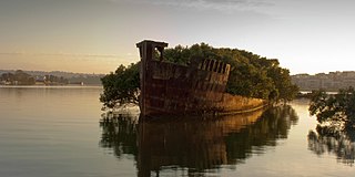
Homebush Bay is a bay on the south bank of the Parramatta River, in the west of Sydney, Australia. The name is also sometimes used to refer to an area to the west and south of the bay itself, which was formerly an official suburb of Sydney, and has now become the suburbs of Sydney Olympic Park, Wentworth Point and part of the neighbouring suburb of Lidcombe, all part of the City of Parramatta. Homebush Bay is located 13 kilometres (8.1 mi) west of the Sydney central business district.

<span class="mw-page-title-main">Carlingford, New South Wales</span> Suburb of Sydney, New South Wales, Australia

Carlingford is a suburb of Sydney, in the state of New South Wales, Australia. Carlingford is 22 kilometres north-west of the Sydney central business district in the local government area of City of Parramatta. Carlingford sits at the meeting point of Northern Sydney and Western Sydney sitting on both sides of Pennant Hills Road which generally acts as a divider of the two regions. While being part of City of Parramatta, it is sometimes referred to as being part of the Hills District.

Dundas is a suburb of Sydney, New South Wales, Australia. Dundas is located 21 kilometres north-west of the Sydney central business district, in the local government area of the City of Parramatta, and the electoral division of Bennelong. Dundas is a leafy green suburb, notably due to its centrepiece The Ponds Walk, which follows the Ponds Subiaco Creek. Dundas is part of the Northern Sydney and Greater Western Sydney regions.

<span class="mw-page-title-main">Rydalmere, New South Wales</span> Suburb of Sydney, New South Wales, Australia

Rydalmere(formerly "Field of Mars") is a suburb of Sydney, in the state of New South Wales, Australia. Rydalmere is approximately 21 kilometres west of the Sydney central business district in the local government area of the City of Parramatta. Rydalmere is part of the Greater Western Sydney region.

<span class="mw-page-title-main">Rydalmere railway station</span> Former railway station in Sydney, Australia

Rydalmere railway station, originally Victoria Road railway station, was a railway station in Sydney, Australia that was open between 1896 and 2020. It was located on the Carlingford line and served the suburb of Rydalmere. At the time of closure, Rydalmere station was served by Sydney Trains T6 Carlingford line services.

<span class="mw-page-title-main">West Ryde, New South Wales</span> Suburb of Sydney, New South Wales, Australia

West Ryde is a suburb of Sydney, in the state of New South Wales, Australia. West Ryde is located 16 kilometres north-west of the Sydney central business district, in the local government area of the City of Ryde and is part of the Northern Sydney region.

<span class="mw-page-title-main">Silverwater</span> Suburb of Sydney, New South Wales, Australia

Silverwater is a suburb in western Sydney, in the state of New South Wales, Australia. Silverwater is located 15 kilometres west of the Sydney central business district on the southern bank of the Parramatta River within the local government area of City of Parramatta.

<span class="mw-page-title-main">Meadowbank, New South Wales</span> Suburb of Sydney, New South Wales, Australia

Meadowbank is a suburb of Sydney, New South Wales, Australia, 15 kilometres north west of the Sydney central business district, in the local government area of the City of Ryde and part of the Northern Sydney region. Meadowbank sits in a valley on the northern bank of the Parramatta River.

<span class="mw-page-title-main">Camellia, New South Wales</span> Suburb of Sydney, New South Wales, Australia

Camellia is a suburb of Sydney, in the state of New South Wales, Australia. Primarily industrial with no residential population, environmental remediation commenced in late 2015, with the suburb ear-marked as a major centre for future high density living.

Denistone East is a suburb in Northern Sydney, Australia. Denistone East is 16 kilometres north-west of the Sydney central business district in the local government area of the City of Ryde. Denistone and Denistone West are separate suburbs; Denistone East was gazetted as a suburb in its own right on 5 February 1999.

<span class="mw-page-title-main">Ermington, New South Wales</span> Suburb of Sydney, New South Wales, Australia

Ermington is a suburb of Sydney, New South Wales, Australia. Ermington is located 19 kilometres West of the Sydney central business district, in the local government area of the City of Parramatta. Ermington lies on the northern bank of the Parramatta River.

<span class="mw-page-title-main">Meadowbank ferry wharf</span>

Meadowbank ferry wharf is located on the northern side of the Parramatta River serving the Sydney suburb of Meadowbank.

<span class="mw-page-title-main">Parramatta River ferry services</span>

Parramatta River ferry services connect suburbs along the Parramatta River in Sydney with Circular Quay by commuter ferry. The services are numbered F3 and form part of the Sydney Ferries network.

<span class="mw-page-title-main">Northern Sydney</span> Region of Sydney in New South Wales, Australia

Northern Sydney is a large metropolitan area in Greater Sydney, New South Wales, Australia on the north shore of Sydney Harbour and Parramatta River. The region embraces suburbs in Sydney's north-east, north and inner north west. Northern Sydney is divided into distinctive regions such as the North Shore, Northern Beaches and Forest District.

<span class="mw-page-title-main">Wentworth Point, New South Wales</span> Suburb of Sydney, New South Wales, Australia

Wentworth Point is a suburb of Sydney, in the state of New South Wales, Australia. It is located 13 kilometres west of the Sydney central business district, on the eastern edge of the local government area of City of Parramatta. It is on the western shore of Homebush Bay on the southern side of the Parramatta River. Wentworth Point is usually regarded as part of the Greater Western Sydney region, including in administrative contexts, but it is also regarded as part of the Inner West region of Sydney in some contexts, especially commercial contexts.

Archer Creek, a northern tributary of the Parramatta River, is a creek west of Sydney Harbour, located in Sydney, New South Wales, Australia. It joins the Parramatta River at Meadowbank Park, Meadowbank.

<span class="mw-page-title-main">Parramatta Light Rail</span> Light rail line under construction in Sydney

The Parramatta Light Rail is a 12-kilometre (7 mi) standard gauge light rail line currently under construction in Sydney, New South Wales, Australia.

The Parramatta Valley cycleway is a 15-kilometre-long (9.3 mi) shared-use path for cyclists and pedestrians that is generally aligned with the Parramatta River in Sydney, New South Wales, Australia. The eastern terminus of the cycleway is at Morrison Bay Park in Ryde and heads west along dedicated bike paths, quiet streets and the river foreshore to its western terminus at Parramatta Park in Parramatta.

References

33°49′11″S151°4′38″E / 33.81972°S 151.07722°E / -33.81972; 151.07722

  1. 1 2 Australian Bureau of Statistics (27 June 2017). "Melrose Park (State Suburb)". 2016 Census QuickStats. Retrieved 14 August 2017. OOjs UI icon edit-ltr-progressive.svg
  2. The Book of Sydney Suburbs, Compiled by Frances Pollon, Angus & Robertson Publishers, 1990, Published in Australia ISBN   0-207-14495-8, page 169
  3. "Parramatta Light Rail to Sydney Olympic Park". Transport for NSW. 18 October 2017. Retrieved 18 October 2017.
  4. Constance, Andrew. "We're planning light rail extension to Sydney Olympic Park to improve public transport for 1000's[sic] of event goers". Twitter. Retrieved 19 October 2017.
  5. "GNB Address Policy and User Manual" (PDF). Geographic Names Board. Retrieved 25 February 2024.
  6. "Plans reveal exciting vision for Melrose Park in Sydney's West". Payce. Retrieved 27 February 2016.
  7. "NSW industrial market in high demand". The Sydney Morning Herald. 18 February 2016. Retrieved 27 February 2016.
  8. Morris, Cathy (17 February 2016). "$5 billion urban renewal for Melrose Park". Parramatta Advertiser. Retrieved 18 November 2016.