Related Research Articles

Port Jackson, consisting of the waters of Sydney Harbour, Middle Harbour, North Harbour and the Lane Cove and Parramatta Rivers, is the ria or natural harbour of Sydney, New South Wales, Australia. The harbour is an inlet of the Tasman Sea. It is the location of the Sydney Opera House and Sydney Harbour Bridge. The location of the first European settlement and colony on the Australian mainland, Port Jackson has continued to play a key role in the history and development of Sydney.

Rhodes is an Inner West suburb of Sydney, in the state of New South Wales, Australia. Rhodes is located 12 kilometres west of the Sydney central business district, in the local government area of the City of Canada Bay. It was formerly part of Concord Municipality until a merger with Drummoyne Council to form Canada Bay in December 2000. People from Rhodes are colloquially known as Rhoders or Rhodesiens.

The Parramatta River is an intermediate tide-dominated, drowned valley estuary located in Sydney, New South Wales, Australia. With an average depth of 5.1 metres (17 ft), the Parramatta River is the main tributary of Sydney Harbour, a branch of Port Jackson. Secondary tributaries include the smaller Lane Cove and Duck rivers.
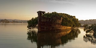
Homebush Bay is a bay on the south bank of the Parramatta River, in the west of Sydney, Australia. The name is also sometimes used to refer to an area to the west and south of the bay itself, which was formerly an official suburb of Sydney, and has now become the suburbs of Sydney Olympic Park, Wentworth Point and part of the neighbouring suburb of Lidcombe, all part of the City of Parramatta. Homebush Bay is located 13 kilometres (8.1 mi) west of the Sydney central business district.

The Lane Cove River, a northern tributary of the Parramatta River, is a tide-dominated, drowned valley estuary west of Sydney Harbour, located in Sydney, New South Wales, Australia. The river is a tributary of the Parramatta River, winding through a bushland valley. It joins Parramatta River at Greenwich and Woolwich, where together they form an arm of Sydney Harbour, and serves as a border along with Middle Harbour separating Sydney's North Shore.

The Ryde Bridge, also called the Uhrs Point Bridge, are two road bridges that carry Concord Road, part of the A3, across Parramatta River from Ryde in the northern suburbs of Sydney to Rhodes in Sydney's inner west, in New South Wales, Australia.
Tennyson Point is a suburb of Sydney, New South Wales, Australia. Tennyson Point is located 10 kilometres west of the Sydney central business district, in the local government area of the City of Ryde and is part of the Northern Sydney region.

West Ryde is a suburb of Sydney, in the state of New South Wales, Australia. West Ryde is located 16 kilometres north-west of the Sydney central business district, in the local government area of the City of Ryde and is part of the Northern Sydney region.

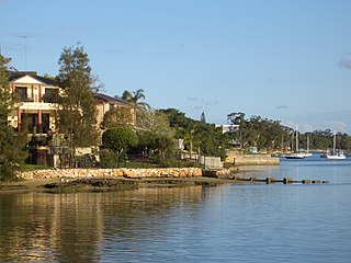
Putney is a suburb of Northern Sydney, New South Wales, Australia. It is located 14 kilometres (9 mi) north-west of the Sydney central business district on the northern bank of the Parramatta River. Its local government area is the City of Ryde.

Meadowbank is a suburb of Sydney, New South Wales, Australia, 15 kilometres north west of the Sydney central business district, in the local government area of the City of Ryde and part of the Northern Sydney region. Meadowbank sits in a valley on the northern bank of the Parramatta River.

Ermington(formerly "Field of Mars") is a suburb of Sydney, New South Wales, Australia. Ermington is located 19 kilometres West of the Sydney central business district, in the local government area of the City of Parramatta. Ermington lies on the northern bank of the Parramatta River.

Iron Cove Creek, a southern tributary of the Parramatta River, is an urban stream west of Sydney Harbour, located in the inner-western Sydney suburbs of Croydon, Ashfield, Haberfield and Five Dock in New South Wales, Australia.

Northern Sydney is a large metropolitan area in Greater Sydney, New South Wales, Australia on the north shore of Sydney Harbour and Parramatta River. The region embraces suburbs in Sydney's north-east, north and inner north west. Northern Sydney is divided into distinctive regions such as the North Shore, Northern Beaches and Forest District.

Haslams Creek, a southern tributary of the Parramatta River, is a creek west of Sydney Harbour, located in Sydney, Australia. It flows through Sydney Olympic Park and joins Parramatta River at Homebush Bay. In 1793, the first grants were made to free settlers, with Samuel Haslam receiving his first grant in 1806. A 50 acre grant north of Parramatta Road, the first grant, was followed by a second small grant south of Parramatta Road and east of Haslams Creek. Haslams Creek flowed through the holdings of the Sydney Meat Preserving Company Ltd 1876-1965, which at one point damned the creek. When opened, Lidcombe railway station actually bore the name Haslams Creek Station

The Duck River is a perennial stream and southern tributary of the Parramatta River, in Sydney, New South Wales, Australia.
Vineyard Creek, a northern tributary of the Parramatta River, is a creek in Sydney, Australia.
Bike paths in Sydney, New South Wales, Australia, vary widely, with the majority either shared cycle and pedestrian paths or on road paths, and a small number of separated cycleways. In 2009 the Sydney Morning Herald reported that "Sydney's cycleways are not so much an organised network as a fragmented collection of winding paths and half-finished ideas. Most were built or designed when cycling was viewed as a pleasant pastime rather than a practical form of travel and are now poorly suited to commuting."
Charity Creek, a northern tributary of the Parramatta River, is a creek west of Sydney Harbour, located in Sydney, New South Wales, Australia. It joins the Parramatta River at Meadowbank Park, Meadowbank.
Smalls Creek, a northern tributary of the Parramatta River, is a creek west of Sydney Harbour, located in Sydney, New South Wales, Australia. It joins the Parramatta River at Meadowbank Park, Meadowbank.
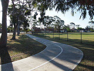
The Parramatta Valley cycleway is a 15-kilometre-long (9.3 mi) shared-use path for cyclists and pedestrians that is generally aligned with the Parramatta River in Sydney, New South Wales, Australia. The eastern terminus of the cycleway is at Morrison Bay Park in Ryde and heads west along dedicated bike paths, quiet streets and the river foreshore to its western terminus at Parramatta Park in Parramatta.
References
- 1 2 "Archers Creek". The Tributaries of the Lane Cove River. 2010. Archived from the original on 20 March 2012. Retrieved 4 September 2012.
- ↑ "Parramatta River Estuary Data Compilation and Review Study" (PDF). Parramatta River Estuary Management Committee. July 2008. p. 15. Retrieved 4 September 2012.
| | This article related to the geography of Sydney is a stub. You can help Wikipedia by expanding it. |