
Rhodes is an Inner West suburb of Sydney, in the state of New South Wales, Australia. Rhodes is located 12 kilometres west of the Sydney central business district, in the local government area of the City of Canada Bay. It was formerly part of Concord Municipality until a merger with Drummoyne Council to form Canada Bay in December 2000. People from Rhodes are colloquially known as Rhoders or Rhodesiens.

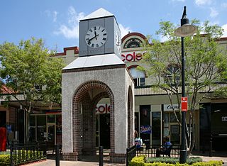
Ryde is a suburb of Sydney, New South Wales, Australia. Ryde is located 13 km north-west of the Sydney central business district and 8 km east of Parramatta. Ryde is the administrative centre of the local government area of the City of Ryde and part of the Northern Sydney region. It lies on the north bank of the Parramatta River. People from Ryde are colloquially known as Ryders, Rydiens or Rydemen.

North Epping is a suburb of Sydney, in the state of New South Wales, Australia 19 kilometres north-west of the Sydney central business district in the local government area of Hornsby Shire. North Epping is in the Northern Sydney region, and is often referred to as part of the "North-West" or North Shore. Epping is a separate suburb to the south and under the Parramatta City Council, which shares the postcode of 2121.

Kissing Point is a point on the Parramatta River about 2 km south of Ryde, located in the suburb of Putney. Historically, the name referred to a much wider area than the current-day point; and perhaps originally to the point near Ryde Bridge where Settlers Park is now located, and where a 1948 brass plaque by the Council states.

Gladesville is a suburb in the Lower North Shore of Sydney, in the state of New South Wales, Australia. Gladesville is located 10 kilometres north-west of the Sydney central business district, in the local government area of the City of Ryde and the Municipality of Hunter's Hill. Gladesville is part of the federal electorates of North Sydney and Bennelong.

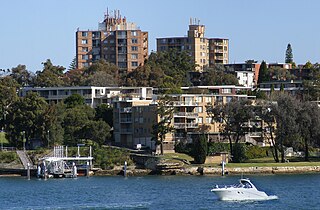
Putney is a suburb of Northern Sydney, New South Wales, Australia. It is located 14 kilometres (9 mi) north-west of the Sydney central business district on the northern bank of the Parramatta River. Its local government area is the City of Ryde.

Meadowbank is a suburb of Sydney, New South Wales, Australia, 15 kilometres north west of the Sydney central business district, in the local government area of the City of Ryde and part of the Northern Sydney region. Meadowbank sits in a valley on the northern bank of the Parramatta River.

Melrose Park is a suburb of Sydney, New South Wales, Australia, located 12 kilometres north-west of the Sydney central business district. Melrose Park is split between the local government areas of the City of Ryde and the City of Parramatta. It is part of the Northern Sydney region. Melrose Park sits on the northern bank of the Parramatta River. The Melrose Park Residents Action Group (MPRAG) represents the community on local issues.
Concord is a suburb in the inner West of Sydney, in the state of New South Wales, Australia. It is 10 kilometres (6.2 mi) west of the Sydney central business district, in the local government area of the City of Canada Bay. Concord West is a separate suburb, to the north-west.

Breakfast Point is a suburb in the Inner West of Sydney, in the state of New South Wales, Australia. Breakfast Point is located 16 kilometres west of the Sydney central business district. It is in the local government area of the City of Canada Bay. People from Breakfast Point are colloquially called Breakfast Pointers.

Camellia is a suburb of Sydney, in the state of New South Wales, Australia. Primarily industrial with no residential population, environmental remediation commenced in late 2015, with the suburb ear-marked as a major centre for future high density living.
Chiswick is a suburb in the Inner West of Sydney, in the state of New South Wales, Australia. It is located 9 kilometres west of the Sydney central business district in the local government area of the City of Canada Bay. Chiswick sits on the peninsula between Abbotsford Bay and Five Dock Bay, on the Parramatta River. It is surrounded by the suburbs of Abbotsford, Russell Lea and Drummoyne.
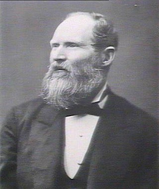
James Squire Farnell was an Australian politician and Premier of New South Wales. Farnell was a hard-working legislator who gave much study to the land question and also tried hard for some years to pass a bill for the regulation of contagious diseases.

Henley is a suburb on the Lower North Shore of Sydney, in the state of New South Wales, Australia. Henley is located 9 kilometres west of the Sydney central business district, in the local government area of the Municipality of Hunter's Hill. Henley sits on the northern side of the Parramatta River.
James Squire, alternatively known as James Squires, was a First Fleet convict transported to Australia. Squire is credited with the first successful cultivation of hops in Australia around the start of the 19th century. First officially brewing beer in Australia in 1790; James later founded Australia's first commercial brewery making beer using barley and hops in 1798, although John Boston appears to have opened a brewery making a form of corn beer two years earlier.

Huntleys Cove is a suburb on the Lower North Shore of Sydney, in the state of New South Wales, Australia. Huntleys Cove is located 9 kilometres north-west of the Sydney central business district, in the local government area of the Municipality of Hunter's Hill. Huntleys Cove sits on the peninsula between Tarban Creek and the Parramatta River.

Northern Sydney is a large metropolitan area in Greater Sydney, New South Wales, Australia on the north shore of Sydney Harbour and Parramatta River. The region embraces suburbs in Sydney's north-east, north and inner north west. Northern Sydney is divided into distinctive regions such as the North Shore, Northern Beaches and Forest District.

Wentworth Point is a suburb of Sydney, in the state of New South Wales, Australia. It is located 13 kilometres west of the Sydney central business district, on the eastern edge of the local government area of City of Parramatta. It is on the western shore of Homebush Bay on the southern side of the Parramatta River. Wentworth Point is usually regarded as part of the Greater Western Sydney region, including in administrative contexts, but it is also regarded as part of the Inner West region of Sydney in some contexts, especially commercial contexts.
William Raven (1756–1814) was an English master mariner, naval officer and merchant. He commanded the whaler and sealing vessel Britannia and the naval store ship HMS Buffalo in Australian and New Zealand waters from 1792 until 1799. While in command of Britannia under contract to the British East India Company, he mapped the Loyalty Islands of Maré, Lifou, Tiga and Ouvéa between August 1793 and May 1796.

