
Darling Harbour is a harbour adjacent to the city centre of Sydney, New South Wales, Australia that is made up of a large recreational and pedestrian precinct that is situated on western outskirts of the Sydney central business district.

The Garigal National Park is a protected national park that is located within the North Shore and Forest District regions of Sydney, New South Wales, in eastern Australia. The 2,202-hectare (5,440-acre) national park is situated approximately 20 kilometres (12 mi) north of the Sydney central business district.

The Sydney Harbour National Park is an Australian national park comprising parts of Port Jackson, Sydney and its foreshores and various islands. The 392-hectare (970-acre) national park lies in New South Wales and was created progressively, from 1975.

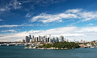
Port Jackson, consisting of the waters of Sydney Harbour, Middle Harbour, North Harbour and the Lane Cove and Parramatta Rivers, is the ria or natural harbour of Sydney, New South Wales, Australia. The harbour is an inlet of the Tasman Sea. It is the location of the Sydney Opera House and Sydney Harbour Bridge. The location of the first European settlement and colony on the Australian mainland, Port Jackson has continued to play a key role in the history and development of Sydney.

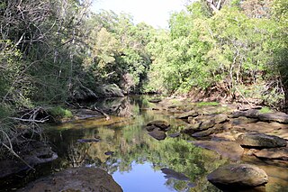
The Lane Cove River, a northern tributary of the Parramatta River, is a tide-dominated, drowned valley estuary west of Sydney Harbour, located in Sydney, New South Wales, Australia. The river is a tributary of the Parramatta River, winding through a bushland valley. It joins Parramatta River at Greenwich and Woolwich, where together they form an arm of Sydney Harbour, and serves as a border along with Middle Harbour separating Sydney's North Shore.

The Northern Beaches is a region within Northern Sydney, in the state of New South Wales, Australia, near the Pacific coast. This area extends south to the entrance of Port Jackson, west to Middle Harbour and north to the entrance of Broken Bay. The area was formerly inhabited by the Garigal or Caregal people in a region known as Guringai country.

Frenchs Forest is a suburb of northern Sydney, in the state of New South Wales, Australia. Frenchs Forest is 13 kilometres north of the Sydney central business district in the local government area of Northern Beaches Council. Frenchs Forest is part of Sydney's Northern Beaches region and also considered to be part of the Forest District, colloquially known as The Forest by its locals.

Middle Harbour, a semi–mature tide dominated drowned valley estuary, is the northern arm of Port Jackson, an inlet of the Tasman Sea located north of Sydney central business district on the coast of New South Wales, Australia.
Goat Island is a heritage-listed island located in Port Jackson, in Sydney, New South Wales, Australia. Located northwest of the Sydney central business district, Goat Island is about 300m wide in a north/south direction and 180m long in an east/west direction; and covers an area of 5.4 hectares. Goat Island lies off the shores of the Sydney suburbs of Balmain and Millers Point, at the junction of Darling Harbour with the main channel of Sydney Harbour.
Forestville is a suburb of Northern Sydney, in the state of New South Wales, Australia. Forestville is 12 kilometres north of the Sydney central business district in the local government area of Northern Beaches Council. Forestville is part of the Forest District.

Pittwater is a semi-mature tide dominated drowned valley estuary, located about 40 kilometres (25 mi) north of the Sydney central business district, New South Wales, Australia; being one of the bodies of water that separate greater Metropolitan Sydney from the Central Coast.
Killarney Heights is a suburb of Northern Sydney, situated on Middle Harbour, in the state of New South Wales, Australia. Killarney Heights is 12 kilometres north-east of the Sydney central business district in the local government area of Northern Beaches Council. Killarney Heights is part of the Forest District, colloquially known as The Forest.

Shark Island is an island located within Sydney Harbour, in New South Wales, Australia. The island is 1.5 hectares in area, measuring some 250 metres by 100 metres, and lies off the Sydney suburbs of Point Piper, Rose Bay and Vaucluse, in the eastern section of the harbour between the Harbour Bridge and the harbour entrance. The island was known by the local Aboriginal people as Boambilly, and the current name comes from its shape, which is claimed to resemble a shark. Shark Island Light is an active pile lighthouse located just north of Shark Island, an island in Sydney Harbour, New South Wales, Australia. Its light is only visible on in the fairway of the harbour, between Shark Point and Point Piper.

The Sydney Heads are a series of headlands that form the 2 km (1.2 mi) wide entrance to Sydney Harbour in Sydney, New South Wales, Australia. North Head and Quarantine Head are to the north; South Head and Dunbar Head are to the south; and Middle Head, Georges Head, and Chowder Head are to the west and within the harbour. The Heads are contained within the Sydney Harbour National Park.

The Steele Point Battery is a small fort, on the shores of Port Jackson in the eastern Sydney suburb of Vaucluse, Australia.

Newington Armory is a heritage-listed former Royal Australian Navy armament depot, now used for tourism purposes, at Holker Street, Sydney Olympic Park, Cumberland Council, New South Wales, Australia. It was built from 1897 initially by the New South Wales Military Forces then by the Australian Army and later by the Royal Australian Navy. It is also known as Millennium Heritage Parklands Precinct, RAN Armament Depot Newington, Royal Australian Navy Armament Depot (RANAD), Newington Nature Reserve and Sydney Olympic Games site. The property is owned by the Sydney Olympic Park Authority. It was added to the New South Wales State Heritage Register on 14 January 2011.
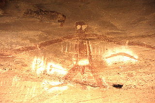
Aboriginal sites of New South Wales consist of a large number of places in the Australian state of New South Wales where it is still possible to see visible signs of the activities and culture of the Australian Aboriginals who previously occupied these areas.

Nielsen Park is a heritage-listed historic site, park and nature reserve located at Greycliffe Avenue, Vaucluse in the Municipality of Woollahra local government area of New South Wales, Australia. The traditional lands of the Birrabirragal indigenous people, the park was designed by John Frederick Hilly, James Barnet and the Office of the New South Wales Government Architect. It is also known as Vaucluse Estate, Greycliffe Estate and Greycliffe House. It was added to the New South Wales State Heritage Register on 28 August 2017.
Bungaroo is a locality near St. Ives, Sydney, Australia. The location is thought to be the site where Governor Arthur Phillip and party camped on the night of 16 April 1788 on the first of many expeditions intended to find arable land that could supply the Colony with agricultural products. The colony at Sydney Cove was dependent on supplies from England, but the soils around the harbour were too poor to support crops and sustain the Colony.
The Bantry Bay Explosives Depot is a heritage-listed former explosives depot at Killarney Heights in the Northern Beaches Council, New South Wales, Australia. It was built in 1915. The property is owned by the Office of Environment and Heritage, an agency of the Government of New South Wales. It was added to the New South Wales State Heritage Register on 2 April 1999.

