| Bilgola Creek Bulgola Creek [1] | |
|---|---|
| Etymology | Aboriginal: belgoula, meaning "swirling waters", or perhaps "a pretty beach with steep slopes, studded with cabbage palms". [2] |
| Location | |
| Country | Australia |
| State | New South Wales |
| Region | Sydney basin (IBRA), Northern Beaches |
| Local government areas | Northern Beaches Council |
| Physical characteristics | |
| Source | Bilgola Escarpment |
| • location | Bilgola Plateau |
| Mouth | confluence with the Tasman Sea |
• location | Bilgola Beach |
• elevation | 0 m (0 ft) |
| Length | 0.5 km (0.31 mi) |
| [3] | |
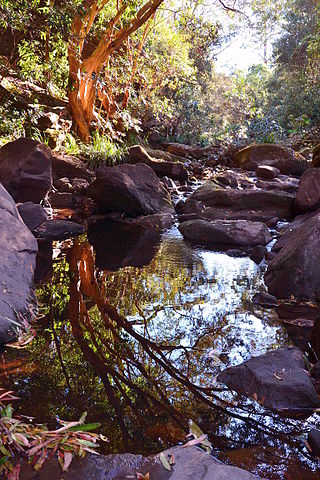
Bilgola Creek is an urban gully [1] or open channel that is located in the northern beaches region of Sydney, New South Wales, Australia.
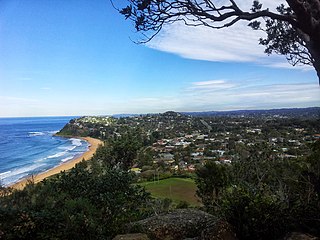
Bilgola Creek rises about 1 kilometre (0.62 mi) west of Bilgola Head and flows generally east by south, from the Bilgola Escarpment through Littoral rainforest, coastal woodland and coastal clay heath communities directly out onto Bilgola Beach and into the Tasman Sea. A smaller ephemeral creek line also flows down from the escarpment at the northern end of Bilgola Beach.

The Northern Beaches is a region within Northern Sydney, in the state of New South Wales, Australia, near the Pacific coast. This area extends south to the entrance of Port Jackson, west to Middle Harbour and north to the entrance of Broken Bay. The area was formerly inhabited by the Garigal or Caregal people in a region known as Guringai country.

Akuna Bay is an urban place in Sydney, Australia. Akuna Bay is located 38 kilometres (24 mi) north of the Sydney central business district, in the local government area of Northern Beaches Council.

The Division of Mackellar is an Australian electoral division in the state of New South Wales.
Salt Pan Creek is an urban watercourse of the Georges River catchment, located in the Canterbury-Bankstown region of Sydney, in New South Wales, Australia.
Oxford Falls is a suburb of northern Sydney, in the state of New South Wales, Australia 20 kilometres north-east of the Sydney central business district in the local government area of Northern Beaches Council. Oxford Falls is part of the Northern Beaches region and also considered to be part of the Forest District, colloquially known as The Forest.

Wolli Creek is an urban watercourse of the Cooks River catchment located in the southern suburbs of Sydney, in New South Wales, Australia.

Bilgola Beach is a suburb in northern Sydney, in the state of New South Wales, Australia 33 kilometres north-east of the Sydney central business district, in the local government area of Northern Beaches Council. It is part of the Northern Beaches region. It and Bilgola Plateau were gazetted as suburbs in 2012 dividing the previous suburb of Bilgola.
Bilgola Plateau is a suburb in Sydney, in the state of New South Wales, Australia.

The Mooney Mooney Creek, a perennial river that is part of the Hawkesbury-Nepean catchment, is located in the Central Coast region of New South Wales, Australia.

Brunswick River is an open mature wave dominated barrier estuary, located in the Northern Rivers region of New South Wales, Australia.

Beardy Waters, a watercourse and part of the Macintyre catchment within the Murray–Darling basin, is located in the Northern Tablelands region of New South Wales, Australia.
The Mangrove Creek, a perennial river that is part of the Hawkesbury-Nepean catchment, is located in the Central Coast region of New South Wales, Australia.
Queens Pound River, a partly perennial river of the Tuross River catchment, is located in the upper ranges of the South Coast region of New South Wales, Australia.

The Mogo Creek, a perennial stream of the Hawkesbury-Nepean catchment, is located in the Blue Mountains region of New South Wales, Australia.

Bare Creek is a watercourse that is part of the Middle Harbour catchment of Sydney Harbour that is located in the northern beaches region of Sydney, New South Wales, Australia.
Boggywell Creek, an urban gully that is part of the Georges River catchment, is located in the southern Sydney district of St George, in New South Wales, Australia.

The Darling Mills Creek, an urban watercourse that is part of the Parramatta River catchment, is located in Greater Western Sydney, New South Wales, Australia.
Devlins Creek, an urban watercourse that is part of the Parramatta River catchment, is located in Northern Suburbs region of Sydney, Australia.
Terrys Creek, an urban watercourse that is part of the Lane Cove River catchment, is located in Northern Suburbs region of Sydney, Australia. It was named after Edward Terry who served as the first mayor of Eastwood municipality.
Gore Creek, an urban watercourse that is part of the Parramatta River catchment, is located in Northern Suburbs region of Sydney, Australia.
33°38′S151°19′E / 33.633°S 151.317°E
| | This New South Wales geography article is a stub. You can help Wikipedia by expanding it. |