Tuggerah Lake

Last updated

Tuggerah Lake
Craigie park view.jpg
Tuggerah Lake as viewed from Craigie Park in Kanwal. The Entrance is also visible in the distant background.
Australia New South Wales relief location map.png
Red pog.svg
Tuggerah Lake
Tuggerah Lake map.png
Location Central Coast, New South Wales, Australia
Coordinates 33°19′S151°29′E / 33.317°S 151.483°E / -33.317; 151.483
Type Intermittently open intermediate wave dominated barrier estuary [1]
Primary inflows Wyong River
Primary outflows The Entrance, Tasman Sea, South Pacific Ocean
Catchment area 714.5 square kilometres (275.9 sq mi) [2]
Basin  countriesAustralia
Surface area80.8 square kilometres (31.2 sq mi) [2]
Average depth2.4 metres (7 ft 10 in) [2]
Water volume193,231.2 megalitres (6,823.90×10^6 cu ft) [2]
Surface elevation0 m (0 ft)
Settlements The Entrance, Wyong
Website NSW Environment & Heritage webpage
References [3]

Tuggerah Lake, an intermittently open intermediate wave dominated barrier estuary [1] that is part of the Tuggerah Lakes, is located within the Central Coast Council local government area in the Central Coast region of New South Wales, Australia. The lake is located near Wyong and is situated about 90 kilometres (56 mi) north of Sydney.

Contents

Features and location

Drawing its catchment from the Wyong River, Ourimbah Creek and Tumbi Creek, at the southern half of Tuggerah Lake, the lake is generally quite shallow with an average depth of 2.4 metres (7 ft 10 in). [2] It is connected with the Tasman Sea through a tidal channel at its southern end known as The Entrance. It is also connected with two smaller lakes, Budgewoi Lake and through that to Lake Munmorah. Tuggerah Lake has a catchment area of 714 square kilometres (276 sq mi) and a surface area of 81 square kilometres (31 sq mi). [2] When full, Tuggerah Lake covers an area of around 5,400 hectares (13,000 acres). [3]

Heavy rains in June 2007 caused Tuggerah Lake to flood, affecting areas of Long Jetty, Killarney Vale and Chittaway Point. On the sea side of the peninsula is Norah Head and its historic lighthouse.

Urban areas

The lake adjoins extensive areas of suburban development. Much of the original settlement bordering the lake was oriented towards domestic tourism; with Sydney residents drawn to the area and staying in camp and early cabin-style accommodation clustered around towns of The Entrance and Long Jetty, from there spreading to Toukley on the northern lakeshore.

Many towns surround the lake including Lake Munmorah, The Entrance, Killarney Vale, Berkeley Vale, Tumbi Umbi, Wyong, Kanwal, Gorokan and Toukley.

Long Jetty AU Long Jetty.jpg
Long Jetty

South of The Entrance is Long Jetty, so named for the jetty built to service the first sub-division of land at The Entrance. The original jetty was washed away in a flood at Easter 1927; the present structure replaced it, built in 1927–28 to a length of 1,152 feet (351 m). Parts of the jetty have fallen into disrepair and it requires frequent periodic repairs and replacement of its structure and decking.

Fishing and boating

Tuggerah Lake is well known for its recreational fishing with species such as luderick, bream, flathead and whiting caught from the shoreline and boats. Prawns can be plentiful over the summer months during the dark of the new moon. Fishing in Tuggerah Lake is generally poor during late winter and early spring, particularly when westerly winds are prevalent.

Special purpose markers (coloured yellow) around Terilbah Island and Pelican Island denote areas where net and trap fishing are restricted. Other parts of the lake may have permanent or temporary fishing restrictions in force. [4]

Due to its large size and shallow depth strong winds can whip up a steep choppy surface that can be hazardous to small boats, however Tuggerah Lake is considered quite safe for most forms of small recreational watercraft if common sense and general safe boating practices are followed. Many parts of Tuggerah Lake are quite shallow with sand or weed flats exposed at low water. Marked channels should be navigated with care and at reduced speed. Mobile phone coverage is available across the entire lake.

Environment

Substantial residential and commercial development, involving excavation and alteration of native vegetation and natural watercourses in the lake catchment and hinterland, has given rise to siltation and changes in the make up of the lakebed and foreshore. During 2004 and 2005 the Tuggerah Lakes Restoration project has been attempting to restore and revive the lake system. Urbanisation and development have caused increased nutrients to build up in the lake stimulating weed growth. Restoration work has focussed on inshore removal of weed and ooze; foreshore reclamation and reinstatement; pollutant traps; and channel dredging to increase the tidal exchange of water with the sea.

Wyrrabalong National Park borders the lake and the sea separating the residential areas of Toukley and The Entrance, and preserves the last significant littoral rainforest on the Central Coast. The lake is part of the Tuggerah Important Bird Area, identified as such by BirdLife International because of its importance for a variety of water and woodland birds. [5]

See also

Related Research Articles

<span class="mw-page-title-main">Central Coast (New South Wales)</span> Region in New South Wales, Australia

The Central Coast is a peri-urban region lying on the Pacific Ocean in northern-eastern New South Wales, Australia. The region is situated north of Sydney, which is filled with subtropical national parks, forests and also encompasses the major coastal waterways of Brisbane Water, Tuggerah Lakes and southern Lake Macquarie. The region's hinterland, which has fertile valleys, rural farmland and wineries, and also includes the Watagan Mountains. The Central Coast is known for its regional coastal towns like Terrigal, The Entrance, Ettalong Beach, Budgewoi and Bateau Bay with resorts and holiday parks, which feature many expansive beaches and lagoons with surfing and coastal tracks, as well as scenic views. Gosford is the main commercial hub and gateway.

<span class="mw-page-title-main">Lake Illawarra</span> Lake in New South Wales, Australia

Lake Illawarra is an open and trained intermediate wave dominated barrier estuary or large coastal lagoon, is located in the Illawarra region of New South Wales, situated about 100 kilometres (62 mi) south of Sydney, Australia.

<span class="mw-page-title-main">Wyong Shire</span> Former local government area in New South Wales, Australia

Wyong Shire was a local government area located in the Central Coast region of New South Wales, Australia. The incorporation of the Wyong area dates back to 7 March 1906 when the entire area of the Brisbane Water Police District outside of the Town of Gosford was proclaimed as the Erina Shire. From 1 January 1947, local government in the Central Coast region was reorganised, creating Gosford Shire and Wyong Shire, which comprised Erina Shire north and east of Kulnura, Central Mangrove and Lisarow.

<span class="mw-page-title-main">Division of Dobell</span> Australian federal electoral division

The Division of Dobell is an Australian electoral division in the state of New South Wales.

<span class="mw-page-title-main">Tumbi Umbi, New South Wales</span> Suburb of Central Coast, New South Wales, Australia

Tumbi Umbi is a mostly semi-rural suburb of the Central Coast region of New South Wales, Australia, located northwest of Bateau Bay along Wyong Road. It is part of the Central Coast Council local government area.

Toukley is a town in the Central Coast region of the Australian state of New South Wales and is located within Central Coast Council. It lies approximately 109 km north of Sydney and 54 km south of Newcastle via the Pacific Motorway (M1). It is located between Tuggerah Lake, Budgewoi Lake, and the Pacific Ocean. At the channel connecting Tuggerah Lake and Budgewoi Lake the new Toukley bridge was constructed between 1983 and 1985 linking Toukley on the eastern side of the Lakes system with Gorokan on the west, replacing the old two lane wooden bridge.

<span class="mw-page-title-main">The Entrance, New South Wales</span> Town in New South Wales, Australia

The Entrance is a coastal town and suburb in the Central Coast region of New South Wales, Australia. It is part of the Central Coast Council local government area. At the 2011 census, The Entrance had a population of 3,873 people.

<span class="mw-page-title-main">Red Bus Services</span> Australian bus company operating route bus services on the New South Wales Central Coast

Red Bus Services is an Australian bus company operating route bus services on the New South Wales Central Coast.

Wyong is an electoral district of the Legislative Assembly in the Australian state of New South Wales. The district is a 640.55 km² urban and semi-rural electorate on the Central Coast. It covers part of Central Coast Council, including the towns of Wyong and Toukley.

The Entrance is an electoral district of the Legislative Assembly located on the Central Coast of New South Wales, Australia.

<span class="mw-page-title-main">Lake Munmorah</span> Lake in Australia

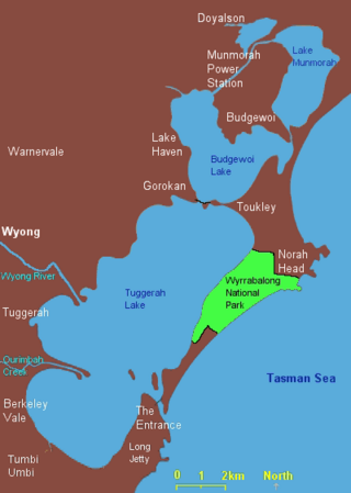
Lake Munmorah or Munmorah Lake, a lagoon that is part of the Tuggerah Lakes, is located within the Central Coast Council local government area in the Central Coast region of New South Wales, Australia. The lake is located near the settlement of Lake Munmorah and is situated about 110 kilometres (68 mi) north of Sydney.

<span class="mw-page-title-main">Lake Macquarie (New South Wales)</span> An open and trained youthful wave dominated barrier estuary in Hunter, Central Coast

Lake Macquarie is Australia's largest coastal lagoon. Located in the City of Lake Macquarie and Central Coast Council local government areas in the Hunter and Central Coast regions of New South Wales, Australia, it covers an area of 110 square kilometres (42.5 sq mi) and is connected to the Tasman Sea by a short channel. Most of the residents of the City of Lake Macquarie live near the shores of the lagoon.

<span class="mw-page-title-main">Tuggerah Lakes</span> Eastern Australian lake system

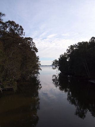
The Tuggerah Lakes, a wetland system of three interconnected coastal lagoons, are located on the Central Coast of New South Wales, Australia and comprise Lake Munmorah, Budgewoi Lake and Tuggerah Lake.

<span class="mw-page-title-main">Budgewoi</span> Town in New South Wales, Australia

Budgewoi is a coastal town that is located on the Central Coast of New South Wales, Australia. Budgewoi is situated on two peninsulas that is split by the Budgewoi Lake. The town is located about 114 km northeast of Sydney. It is part of the Central Coast Council local government area.

<span class="mw-page-title-main">Killarney Vale, New South Wales</span> Suburb of Central Coast, New South Wales, Australia

Killarney Vale is a suburb of the Central Coast region of New South Wales, Australia, located approximately 5 kilometres south of The Entrance. It is part of the Central Coast Council local government area.

<span class="mw-page-title-main">Central Coast Division Rugby League</span> Rugby league competition

The Central Coast Division of Country Rugby League is a rugby league competition based on the Central Coast of New South Wales between Sydney and Newcastle. The competition was founded in 1947 as a junior competition for the Newcastle club, Lakes United. The competition rapidly expanded and grew, so much so that in 1967, it was upgraded to full membership of the Country Rugby League as Group 12. In 1981, it was upgraded and renamed Central Coast Division. The division covers the entire region of the Central Coast from Woy Woy and Umina in the south up to Budgewoi and Gwandalan in the north.

Tuggerah was an electoral district for the Legislative Assembly in the Australian State of New South Wales, which partly replaced Munmorah in 1981 and was named after the Tuggerah Lakes. In 1988, it was replaced by Wyong and The Entrance. Its only member was Harry Moore, representing the Labor Party.

<span class="mw-page-title-main">Budgewoi Lake</span> Lagoon in New South Wales, Australia

The Budgewoi Lake is a lagoon that is part of the Tuggerah Lakes, that is located within the Central Coast Council local government area in the Central Coast region of New South Wales, Australia. The lake is located near the settlement of Budgewoi and is situated about 100 kilometres (62 mi) north of Sydney.

<span class="mw-page-title-main">Wyong River</span> River in New South Wales, Australia

The Wyong River is a perennial river that is located in the Central Coast region of New South Wales, Australia.

References

  1. 1 2 Roy, P. S; Williams, R. J; Jones, A. R; Yassini, I; et al. (2001). "Structure and Function of South-east Australian Estuaries". Estuarine, Coastal and Shelf Science . 53: 351–384. doi:10.1006/ecss.2001.0796.
  2. 1 2 3 4 5 6 "Estuaries of NSW: Tuggerah Lake". Office of Environment and Heritage. Government of New South Wales . Retrieved 20 March 2013.
  3. 1 2 "Map of Tuggerah Lake, NSW". Bonzle Digital Atlas of Australia. Retrieved 20 March 2013.
  4. "Tuggerah Lakes Restrictions". NSW Primary Industries . Government of New South Wales.
  5. BirdLife International. (2011). Important Bird Areas factsheet: Tuggerah. Downloaded from http://www.birdlife.org on 17 November 2011.