
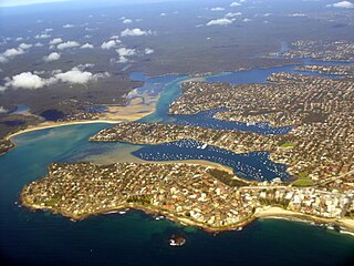
Brisbane Water is a wave-dominated barrier estuary located in the Central Coast region of New South Wales, Australia. Brisbane Water has its origin at the confluence of the Narara and Coorumbine Creeks, to the south–east of Gosford and travels for approximately 18 kilometres (11 mi) in a southerly direction to its mouth at Broken Bay, about 7 kilometres (4.3 mi) from the Tasman Sea, at Barrenjoey Head. A number of towns and suburbs surround the shores of Brisbane Water, including Blackwall, Booker Bay, Davistown, Empire Bay, Erina, Ettalong Beach, Gosford, Green Point, Hardys Bay, Kilcare, Kincumber, Koolewong, Phegans Bay, Point Frederick, Point Clare, Saratoga, Tascott, Wagstaffe, and Woy Woy. Contained within Brisbane Water is St Huberts Island, Rileys Island, Dunmar Island and Pelican Island; and adjoining the estuary is Brisbane Water National Park to the west and Bouddi National Park to the east. Forming part of the same tidal estuary system is a separate but connected basin, the Kincumber Broadwater, lying to the east of Davistown.

Tuggerah Lake, an intermittently open intermediate wave dominated barrier estuary that is part of the Tuggerah Lakes, is located within the Central Coast Council local government area in the Central Coast region of New South Wales, Australia. The lake is located near Wyong and is situated about 90 kilometres (56 mi) north of Sydney.

Lake Illawarra is an open and trained intermediate wave dominated barrier estuary or large coastal lagoon, is located in the Illawarra region of New South Wales, situated about 100 kilometres (62 mi) south of Sydney, Australia.

Port Stephens, an open youthful tide-dominated drowned-valley estuary, is a large natural harbour of approximately 134 square kilometres (52 sq mi) located in the Hunter and Mid North Coast regions of New South Wales, Australia.

The Clyde River is an open intermediate tide-dominated drowned valley estuary or perennial river that flows into the Tasman Sea at Batemans Bay, located in the South Coast region of New South Wales, Australia.
Port Hacking Estuary, an open youthful tide dominated, drowned valley estuary, is located in southern Sydney, New South Wales, Australia approximately 30 kilometres (19 mi) south of Sydney central business district. Port Hacking has its source in the upper reaches of the Hacking River south of Helensburgh, and several smaller creeks, including South West Arm, Bundeena Creek and The Basin and flows generally to the east before reaching its mouth, the Tasman Sea, south of Cronulla and north–east of Bundeena. Its tidal effect is terminated at the weir at Audley, in the Royal National Park. The lower estuary features a substantial marine delta, which over time has prograded upstream. There is also a substantial fluvial of the Hacking River at Grays Point. The two deltas are separated by a deep basin.

Bermagui River is an open and trained semi-mature wave dominated barrier estuary or perennial river located in the South Coast region of New South Wales, Australia.
The Merrica River is an intermediate intermittently closed saline coastal lagoon or perennial river located in the South Coast region of New South Wales, Australia.
Murrah River is an open mature wave dominated barrier estuary or perennial river located in the South Coast region of New South Wales, Australia.
The Nadgee River is a mature intermittently closed saline coastal lagoon; or perennial river located in the South Coast region of New South Wales, Australia.
The Nullica River is an intermittently closed semi-mature saline coastal lagoon or perennial river, located in the South Coast region of New South Wales, Australia.
Pambula River is an open semi-mature wave dominated barrier estuary or perennial river located in the South Coast region of New South Wales, Australia.
The Tomaga River, an open mature wave dominated barrier estuary or perennial stream, is located in the South Coast region of New South Wales, Australia.
The Towamba River is an open mature wave dominated barrier estuary or perennial river, located in the South Coast region of New South Wales, Australia.

The Tuross River, an open semi-mature wave dominated barrier estuary or perennial stream, is located in the South Coast region of New South Wales, Australia.
The Wonboyn River, an open youthful wave dominated barrier estuary or perennial stream, is located in the South Coast region of New South Wales, Australia.
The Bega River is an intermittently open intermediate wave dominated barrier estuary that is located in the South Coast region of New South Wales, Australia.
Smiths Lake, an intermittently closed youthful saline coastal lagoon, is located within the Mid-Coast Council local government area in the Mid North Coast region of New South Wales, Australia. Smiths Lake is located adjacent to the village of Smiths Lake, and adjacent to the east coast, about 274 kilometres (170 mi) north of Sydney.

The Avoca Lake, formerly known as Avoca Lagoon and as Bulbararing Lagoon, is an intermittently closed intermediate saline coastal lagoon that is located on the Central Coast of New South Wales, Australia. Avoca Lake is located between the beachside settlements of North Avoca and Avoca Beach, and adjacent to the Pacific Ocean, about 85 kilometres (53 mi) north of Sydney.

Batemans Bay is an open oceanic embayment that is located in the South Coast region of New South Wales, Australia. The bay forms the mouth of the Clyde River and its primary outflow is to the Tasman Sea of the South Pacific Ocean.

