
The Shire of Augusta Margaret River is a local government area in the south-west corner of the South West region of Western Australia, approximately 270 kilometres (168 mi) south of Perth. The shire covers an area of 2,243 square kilometres (866 sq mi) and had a population of over 14,000 at the 2016 Census, about half of whom live in the towns of Margaret River and Augusta.
Picnic Point, a suburb of local government area City of Canterbury-Bankstown, is 23 kilometres south-west of the Sydney central business district, in the state of New South Wales, Australia. It is a part of South-western Sydney region. Picnic Point is a residential suburb on the northern bank of the Georges River. Located within Picnic Point is Yeramba Lagoon which is the largest tract of National Park within the Canterbury – Bankstown Council, it is home to numerous species of native fauna and flora.

Malua Bay is a locality in the South Coast region of the state of New South Wales, Australia. It is situated in the Eurobodalla Shire. At the 2016 census, Malua Bay had a population of 1,929.

Broulee is a town on the south coast of New South Wales between Batemans Bay and Moruya. At the 2016 census, the town had a population of 1,717. Just off the beach is Broulee Island, currently joined to the mainland, but in past years the connecting spit has been covered by water, at times a very deep navigable channel with a strong current.

River Heads is a coastal town and locality in the Fraser Coast Region, Queensland, Australia. In the 2021 census, the locality of River Heads had a population of 2,044 people.
Fishermans Bay is a small suburb of the Port Stephens local government area in the Hunter Region of New South Wales, Australia. It is located on the coast of the Tasman Sea adjacent to Anna Bay. A large part of the eastern portion of the suburb is occupied by Tomaree National Park and only a very small portion of the south western corner of the suburb is populated. The suburb is named after the adjacent bay.

The Shire of Dandaragan is a local government area located in the Wheatbelt region of Western Australia, about 200 kilometres (124 mi) north of the state capital, Perth. The Shire covers an area of 6,716 square kilometres (2,593 sq mi) and its seat of government is the town of Jurien Bay.

Baird Bay is a small fishing village located 50 kilometres south of Streaky Bay on the west coast of Eyre Peninsula in South Australia. It is situated on the east coast of a bay named Baird Bay which opens into the north end of Anxious Bay.
The Shire of Denmark is a local government area in the Great Southern region of Western Australia, about 55 kilometres (34 mi) west of Albany and about 420 kilometres (261 mi) south-southeast of the state capital, Perth. The Shire of Denmark covers an area of 1,860 square kilometres (718 sq mi), and its seat of government is located in the townsite and locality of Denmark.
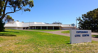
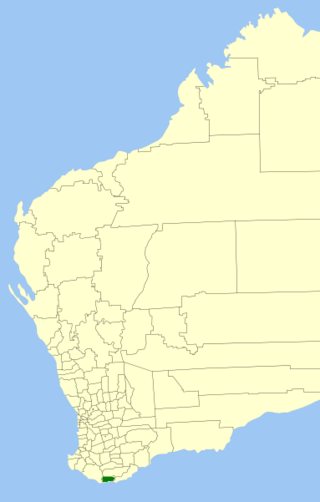
The Shire of Esperance is a local government area in the Goldfields-Esperance region of Western Australia, about 400 kilometres (250 mi) south of the town of Kalgoorlie and about 720 kilometres (450 mi) east-southeast of the state capital, Perth. The Shire covers an area of 42,547 square kilometres (16,427 sq mi), and its seat of government is the town of Esperance, where about three-quarters of the Shire's population resides.
Glenquarry is a locality in the Southern Highlands of New South Wales, Australia, in Wingecarribee Shire. It is a scattered village on the banks of the Wingecarribee River.
Mylestom is a small town in New South Wales, Australia, located on the coast near the mouth of the Bellinger River. At the 2021 census, Mylestom had a population of 336.
Turkey Beach is a coastal town and locality in the Gladstone Region, Queensland, Australia. In the 2021 census, the locality of Turkey Beach had a population of 148 people.
Toomulla is a coastal town and suburb in the City of Townsville, Queensland, Australia. In the 2021 census, the suburb of Toomulla had a population of 193 people.

Green Head is a small Australian coastal town in the Shire of Coorow. The town is situated between Geraldton and Perth in the Mid West region of Western Australia along Indian Ocean Drive. Its beaches and lifestyle provide a relaxed holiday atmosphere. It is the home of what was a significant, but now declining, rock lobster industry.
Burpengary East is a coastal suburb in the City of Moreton Bay, Queensland, Australia. In the 2021 census, Burpengary East had a population of 9,654 people.
Port Moorowie is a small town in the Australian state of South Australia on the south coast of Yorke Peninsula. It has relatively calm beaches and a boat ramp on McLeod Harbour at the western end of Waterloo Bay in Investigator Strait. The town is predominantly a collection of holiday houses and shacks.

Broken Head is a coastal feature (promontory/headland) and suburb located in the Northern Rivers region of New South Wales, Australia, approximately 9 km south of Cape Byron, the easternmost point of Australia, the closest town being Byron Bay. Immediately adjacent is the 98-hectare (240-acre) Broken Head Nature Reserve which contains an intact segment of littoral rainforest. The suburb of Broken Head contained a population of 225 at the 2011 national census, and in addition supports some tourist accommodation and a campsite. The area is noted for its Aboriginal culture, rainforest walks, whale watching and fishing from pristine beaches, and it is also highly regarded as a surfing locality. The Broken Head Holiday Park is currently administered by the indigenous Arakwal people, having been passed to their control by the New South Wales Crown Lands Department in 2009.
Dunnrock is a coastal rural locality in the Mackay Region, Queensland, Australia. In the 2021 census, Dunnrock had a population of 58 people.
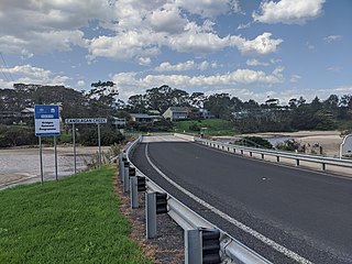
Mossy Point is a suburb in Eurobodalla Shire, New South Wales, Australia. It lies on the Tasman Sea coast to the north of Broulee, separated by Candlagan Creek. It is about 14 km northeast of Moruya and 290 km south of Sydney. At the 2021 census, it had a population of 608.


