
Moruya is a town located on the far south coast of New South Wales, Australia, situated on the Moruya River. The Princes Highway runs through the town that is about 305 km (190 mi) south of Sydney and 175 km (109 mi) from Canberra. At the 2021 census, Moruya had a population of 4,295. Its built-up area had a population of 2,762. The town relies predominantly on agriculture, aquaculture, and tourism. Moruya is administered by the Eurobodalla Shire Council and the shire chambers are located in the town.

Batemans Bay is a town in the South Coast region of the state of New South Wales, Australia. Batemans Bay is administered by the Eurobodalla Shire council. The town is situated on the shores of an estuary formed where the Clyde River meets the southern Pacific Ocean.

Hervey Bay is a city on the coast of the Fraser Coast Region of Queensland, Australia. The city is situated approximately 290 kilometres (180 mi) or 3½ hours' highway drive north of the state capital, Brisbane. It is located on the bay of the same name open to the Coral Sea between the Queensland mainland and nearby K'gari. The local economy relies on tourism which is based primarily around whale watching in Platypus Bay to the north, ferry access to K'gari, accessible recreational fishing and boating and the natural north facing, calm beaches with wide undeveloped foreshore zones. In October 2019, Hervey Bay was named the First Whale Heritage Site in the world by the World Cetacean Alliance, for its commitment to and practices of sustainable whale and dolphin watching.

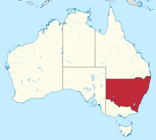
Eurobodalla Shire is a local government area located in the South Coast region of New South Wales, Australia. The Shire is located in a largely mountainous coastal region and situated adjacent to the Tasman Sea, the Princes Highway and the Kings Highway.

Malua Bay is a locality in the South Coast region of the state of New South Wales, Australia. It is situated in the Eurobodalla Shire. At the 2016 census, Malua Bay had a population of 1,929.
New South Wales is Australia's most populous state, located in the east coast of the continent. It is in the southern hemisphere between latitudes 28 and 38 degrees south of the equator and longitudes 141 and 154 degrees east of the Universal Prime Meridian. The state is in the warm temperate climatic zone.

Narooma is a town in the Australian state of New South Wales on the far south coast. The town is on the Princes Highway, which crosses the Wagonga Inlet to North Narooma. The heritage town of Central Tilba is nearby to the south.

Rosedale is a beachside settlement in New South Wales, Australia. It is on the south coast, about 18 kilometres by road south of Batemans Bay. The area is administered by the Eurobodalla Shire. At the 2016 census, Rosedale had a population of 221.
The South Coast refers to the narrow coastal belt from the Shoalhaven district in the north to the state border with Victoria in the south in the south-eastern part of the State of New South Wales, Australia. It is bordered to the west by the coastal escarpment of the Southern Tablelands, and is largely covered by a series of national parks, namely Jervis Bay National Park, Eurobodalla National Park, and Beowa National Park. To the east is the coastline of the Pacific Ocean, which is characterised by rolling farmlands, small towns and villages along a rocky coastline, interspersed by numerous beaches and lakes.

Mystery Bay is a small town on the south coast of New South Wales, Australia. Mystery Bay is halfway between Central Tilba and Narooma, two kilometres off the Princes Highway on Mystery Bay Road. At the 2016 census, Mystery Bay had a population of 191. Mystery Bay features a camping area in the Eurobodalla National Park. This park is known for its recreational activities and various species of Bird. Montague Island is close to Mystery Bay and is known for its unusual quantities of Penguin called Eudyptula minor and fur seals. There is also an Infestation of a specific type of House mouse called Mus musculus which has needed eradication because of its damage on the ecosystem.

Australia's climate is governed mostly by its size and by the hot, sinking air of the subtropical high pressure belt. This moves north-west and north-east with the seasons. The climate is variable, with frequent droughts lasting several seasons, thought to be caused in part by the El Niño-Southern Oscillation. Australia has a wide variety of climates due to its large geographical size. The largest part of Australia is desert or semi-arid. Only the south-east and south-west corners have a temperate climate and moderately fertile soil. The northern part of the country has a tropical climate, varying between grasslands and desert. Australia holds many heat-related records: the continent has the hottest extended region year-round, the areas with the hottest summer climate, and the highest sunshine duration.
South Durras is a small village on the South Coast of New South Wales, Australia. South Durras is located approximately 280 kilometres south of Sydney and 15 kilometres north of Batemans Bay, in the local government area of Eurobodalla Shire. The village is surrounded by the Murramarang National Park.

Tasmania has a cool temperate climate with four distinct seasons. The highest recorded maximum temperature in Tasmania is 42.2 °C (108.0 °F) at Scamander on 30 January 2009, during the 2009 southeastern Australia heat wave. Tasmania's lowest recorded minimum temperature is −14.2 °C (6.4 °F) on 7 August 2020, at Central Plateau.

The geography of Queensland in the north-east of Australia, is varied. It includes tropical islands, sandy beaches, flat river plains that flood after monsoon rains, tracts of rough, elevated terrain, dry deserts, rich agricultural belts and densely populated urban areas.
Congo is a village in Eurobodalla Shire on the South Coast of New South Wales. Congo is located 315 km south of Sydney, and 10 km south of Moruya.

Lilli Pilli is a suburb of Batemans Bay in Eurobodalla Shire, New South Wales, Australia. It lies on the Tasman Sea coast, about 10 km southeast of Batemans Bay and 285 km south of Sydney. At the 2016 census, it had a population of 629.
Surf Beach is a suburb of Batemans Bay in Eurobodalla Shire, New South Wales, Australia. It lies on the Tasman Sea coast, about 10 km southeast of Batemans Bay and 285 km south of Sydney. At the 2016 census, it had a population of 1,874.
Denhams Beach is a suburb of Batemans Bay in Eurobodalla Shire, New South Wales, Australia. It lies on the Tasman Sea coast, about 7 km (4 mi) southeast of Batemans Bay and 285 km (177 mi) south of Sydney. At the 2016 census, it had a population of 648.

Sunshine Bay is a suburb of Batemans Bay in Eurobodalla Shire, New South Wales, Australia. It lies on the Tasman Sea coast, about 6 km southeast of Batemans Bay and 285 km south of Sydney. At the 2016 census, it had a population of 1,221.
Catalina is a suburb of Batemans Bay in Eurobodalla Shire, New South Wales, Australia. It lies near the Tasman Sea coast, about 3 km southeast of Batemans Bay and 285 km south of Sydney. At the 2016 census, it had a population of 2,334.


