
Bald Rock National Park is a national park in northern New South Wales, Australia, just north of Tenterfield on the Queensland border. The border passes over the rock on the Western side. On the other side of the border national park continues as the Girraween National Park.

Biriwal Bulga National Park is an Australian national park in New South Wales. It is approximately 45 km north west of Taree and 60 km west of Port Macquarie on the Bulga Plateau.

Brisbane Water National Park is a national park on the Central Coast of New South Wales, Australia. The national park is situated 70 kilometres (43 mi) north of Sydney and 12 kilometres (7.5 mi) southwest of Gosford. It consists the Brisbane Water and Mooney Mooney Creek waterways.

Conjola National Park covers 11,060 hectares and lies on the mid south coast of New South Wales, Australia, between Sussex Inlet and Lake Conjola, 165 km southwest of Sydney.

The Mallee Cliffs National Park is a protected national park that is located in the Sunraysia region, in the south-west of New South Wales, Australia. The 57,969-hectare (143,240-acre) national park is situated approximately 790 kilometres (490 mi) west of Sydney and 30 kilometres (19 mi) east of the Murray River city of Mildura, Victoria.

The Nightcap National Park is a national park situated within the Nightcap Range in the Northern Rivers region of New South Wales, Australia. The 8,080-hectare (20,000-acre) park was created in April 1983 and is situated 35 kilometres (22 mi) north of Lismore. The park was established following campaigns and blockades against logging at Terania Creek, Grier's Scrub and Mount Nardi between 1979 and 1982. Sections of the Whian Whian state forest were added to it following blockading and campaigning in 1998. The national park is classed by the IUCN World Commission on Protected Areas as Category II and is part of the Shield Volcano Group of the World Heritage Site Gondwana Rainforests of Australia inscribed in 1986 and added to the Australian National Heritage List in 2007.

The Chiltern-Mt Pilot National Park is a national park that is located in the Hume region of Victoria, Australia. The 21,650-hectare (53,500-acre) national park is situated approximately 275 kilometres (171 mi) northeast of Melbourne, and extends west from Beechworth across the Hume Freeway and the Albury-Melbourne railway line to the west of Chiltern.

The Australian Alps are a mountain range in southeast Australia. The range comprises an interim Australian bioregion, and is the highest mountain range in Australia. The range straddles the borders of eastern Victoria, southeastern New South Wales, and the Australian Capital Territory. It contains Australia's only peaks exceeding 2,000 m (6,600 ft) in elevation, and is the only bioregion on the Australian mainland in which deep snow falls annually. The range comprises an area of 1,232,981 ha.

Corroboree frogs comprise two species of frog native to the Southern Tablelands of Australia. Both species are small, poisonous ground-dwelling frogs. The two species are the southern corroboree frog and the northern corroboree frog. They are unique among frogs in that they produce their own poison rather than obtain it from their food source as is the case in every other poisonous frog species.

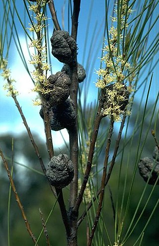
Eidothea hardeniana, commonly named nightcap oak, is a species of tree, up to 40 m (130 ft) tall, of the plant family Proteaceae, which botanist Robert Kooyman recognised as a new species only recently in 2002. It is found only in the Nightcap Range in northern New South Wales, Australia. The species has an official listing as critically endangered on the Australian Commonwealth EPBC Act and as Endangered on the NSW Threatened Species Act. The name hardeniana honours the botanist Gwen Harden. Phylogenetics studies now suggest it represents a basal branch of the Proteoid clade of the Proteaceae.

Cannabis is a plant used in Australia for recreational, medicinal and industrial purposes. In 2019, 36% of Australians over the age of fourteen years had used cannabis in their lifetime and 11.6% had used cannabis in the last 12 months.

Persoonia levis, commonly known as the broad-leaved geebung, is a shrub native to New South Wales and Victoria in eastern Australia. It reaches 5 m (16 ft) in height and has dark grey papery bark and bright green asymmetrical sickle-shaped leaves up to 14 cm (5.5 in) long and 8 cm (3.2 in) wide. The small yellow flowers appear in summer and autumn, followed by small green fleshy fruit, which are classified as drupes. Within the genus Persoonia, it is a member of the Lanceolata group of 58 closely related species. P. levis interbreeds with several other species where they grow together.
The Burrinjuck Nature Reserve is a protected nature reserve on the south west slopes of New South Wales, Australia. The 5,250-hectare (13,000-acre) reserve is located adjacent to the Burrinjuck Dam, with 5,118 hectares of the reserve located on the northern side of the reservoir, and the remaining 89 hectares located on the southern side of the reservoir to the northeast of Black Andrew Nature Reserve. It includes land formerly managed as the Burrinjuck State Forest and Burrinjuck State Recreation Area.
Hakea dohertyi, commonly known as the Kowmung hakea, is a shrub endemic to a restricted locale in the Great Dividing Range in central New South Wales in Australia.
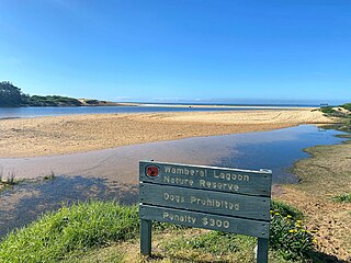
Wamberal Lagoon, an intermittently closed intermediate saline coastal lagoon, is located on the Central Coast region of New South Wales, Australia. Wamberal Lagoon is located between the beachside settlements of Forresters Beach and Wamberal, and adjacent to the Pacific Ocean, about 87 kilometres (54 mi) north of Sydney.
The Western Sydney Parklands is an urban park system and a nature reserve located in Sydney, New South Wales, Australia. The NSW government has spent around $400 million for the park. The park is governed by the NSW National Parks and Wildlife Service and is listed under the National Parks and Wildlife Act 1974. The Parklands begin in the north in the City of Blacktown, cross the City of Fairfield, and end in the City of Liverpool.
The Kangaroo River Nature Reserve, part of the Kangaroo Valley Group of Nature Reserves, is a protected nature reserve that is located on the floor of the Kangaroo Valley in the Southern Highlands and South Coast regions of New South Wales in eastern Australia. The reserve is situated approximately 150 kilometres (93 mi) south of Sydney, 50 kilometres (31 mi) southwest of Wollongong and 16 kilometres (9.9 mi) northwest of Nowra. The reserve has a protective covenant placed upon it with purpose to ensure the protection of the natural heritage of this area. National parks in the area include the Morton National Park and the Budderoo National Park. Other nature reserves in the area include the Barren Grounds Nature Reserve, and the Cambewarra Range, Barrengarry and Rodway nature reserves – the latter three part of the Kangaroo Valley Group of Nature Reserves.

The Dharawal National Park is a protected national park that is located in the Illawarra region of New South Wales, in eastern Australia. The 6,508-hectare (16,080-acre) national park is situated between the Illawarra Range and the Georges River and is approximately 45 kilometres (28 mi) south west of Sydney. There are three entry points to the park: from the east through Darkes Forest; from the north through Wedderburn; and from the south through Appin.

Caleana major, commonly known as the large duck orchid, is a small orchid found in eastern and southern Australia. This terrestrial plant features a remarkable flower, resembling a duck in flight. The flower is an attractant to insects, such as male sawflies which pollinate the flower in a process known as pseudocopulation. In 1986 this orchid was featured on an Australian postage stamp.

The 2019–20 Australian bushfire season, or Black Summer, was one of the most intense and catastrophic fire seasons on record in Australia. It included a period of bushfires in many parts of Australia, which, due to its unusual intensity, size, duration, and uncontrollable dimension, was considered a megafire by media at the time. Exceptionally dry conditions, a lack of soil moisture, and early fires in Central Queensland led to an early start to the bushfire season, beginning in June 2019. Hundreds of fires burnt, mainly in the southeast of the country, until May 2020. The most severe fires peaked from December 2019 to January 2020.

