
The Border Ranges National Park is a protected national park that is located in the Northern Rivers region of New South Wales, Australia. A small portion of the national park is also located in South East Queensland. The 31,729-hectare (78,400-acre) park is situated approximately 150 kilometres (93 mi) south of Brisbane, north of Kyogle.

Mebbin is a national park located in New South Wales, Australia, 633 kilometres (393 mi) north of Sydney. It is part of the Shield Volcano Group of the World Heritage Site Gondwana Rainforests of Australia inscribed in 1983 and added to the Australian National Heritage List in 2007. It is also part of the Scenic Rim Important Bird Area, identified as such by BirdLife International because of its importance in the conservation of several species of threatened birds.
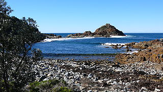
Mimosa Rocks is a national park in New South Wales, Australia, 329 km southwest of Sydney near the towns of Tathra and Bermagui. The park is close to Bournda National Park and forms part of the Ulladulla to Merimbula Important Bird Area, identified as such by BirdLife International because of its importance for swift parrots.
The Mount Clunie National Park is a protected national park that is located in the Northern Rivers region of New South Wales, Australia. The 1,426-hectare (3,520-acre) park is situated approximately 631 kilometres (392 mi) north of Sydney and can be located via Kyogle via the Bruxner Highway and the Summerland Way. The park's north-eastern limits define the state border between New South Wales and Queensland.
The Mount Nothofagus National Park is a protected national park located in the Northern Rivers region of New South Wales, Australia. The 2,180-hectare (5,400-acre) park is located approximately 634 kilometres (394 mi) north of Sydney and can be located via Kyogle via the Bruxner Highway and the Summerland Way.
Wollumbin National Park is a national park located in northern New South Wales, Australia, 642 kilometres (399 mi) north of Sydney near the border with the state of Queensland. It surrounds Mount Warning, part of a remnant caldera of a much larger extinct volcano. The park is administered by the NSW National Parks and Wildlife Service. The park is part of the Scenic Rim Important Bird Area, identified as such by BirdLife International because of its importance in the conservation of several species of threatened birds.
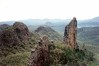
Warrumbungle National Park is a heritage listed national park located in the Orana region of New South Wales, Australia. The national park is located approximately 550 kilometres (340 mi) northwest of Sydney and contained within 23,311 hectares. The park attracts approximately 35,000 visitors per annum.

The Werrikimbe National Park is a protected national park located in the catchment zone of the Upper Hastings River in New South Wales, Australia. Gazetted in 1975, the 33,309-hectare (82,310-acre) park is situated approximately 486 kilometres (302 mi) north of Sydney and 65 kilometres (40 mi) from Wauchope, and 90 kilometres (56 mi) east of Walcha on the eastern escarpment of the Great Dividing Range.
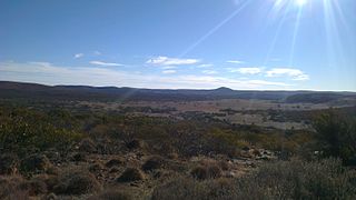
Gawler Ranges National Park is a 1,633 km2 (631 sq mi) protected area lying 350 km (217 mi) north-west of Adelaide in the northern Eyre Peninsula of South Australia. It is known for its spectacular rock formations.

The Lamington National Park is a national park, lying on the Lamington Plateau of the McPherson Range on the Queensland/New South Wales border in Australia. From Southport on the Gold Coast the park is 85 kilometres (53 mi) to the southwest and Brisbane is 110 kilometres (68 mi) north. The 20,600 hectares Lamington National Park is known for its natural environment, rainforests, birdlife, ancient trees, waterfalls, walking tracks and mountain views.

The Main Range is a mountain range and national park in Queensland, Australia, located predominantly in Tregony, Southern Downs Region, 85 kilometres (53 mi) southwest of Brisbane. It is part of the World Heritage Site Gondwana Rainforests of Australia. It protects the western part of a semicircle of mountains in South East Queensland known as the Scenic Rim. This includes the largest area of rainforest in South East Queensland. The park is part of the Scenic Rim Important Bird Area, identified as such by BirdLife International because of its importance in the conservation of several species of threatened birds.

Moogerah Peaks is a National Park in the Fassifern Valley of South East Queensland, Australia, located approximately 70 km south west of the state capital Brisbane. The 676-hectare park consists of four separate protected areas which surround volcanic peaks and rocky cliffs near Moogerah Dam.
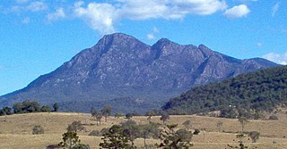
Mount Barney National Park is a national park in Queensland (Australia), 90 km southwest of Brisbane. It amalgamated the adjacent Mount Lindesay National Park in 1980. It is part of the Scenic Rim Important Bird Area, identified as such by BirdLife International because of its importance in the conservation of several species of threatened birds.

Mount Chinghee is a national park in Queensland, Australia, 93 kilometres (58 mi) south of Brisbane. It is part of the Shield Volcano Group of the World Heritage Site Gondwana Rainforests of Australia inscribed in 1986 and added to the Australian National Heritage List in 2007. It is also part of the Scenic Rim Important Bird Area, identified as such by BirdLife International because of its importance in the conservation of several species of threatened birds.
The Limpinwood Nature Reserve is a protected nature reserve that is located on the Northern Rivers region of New South Wales, in eastern Australia. The reserve was gazetted in April 1963 with additions made in 1967, over former fauna and crown reserves, and further additions were made in 1988 to make the reserve to its current area of 2,646 hectares. The reserve is situated north-west of the rural locality of Limpinwood, and north of Tyalgum and defines part of the state border between New South Wales and Queensland.

The New River is a river which flows through the U.S. states of North Carolina, Virginia, and West Virginia before joining with the Gauley River to form the Kanawha River at the town of Gauley Bridge, West Virginia. Part of the Ohio River watershed, it is about 360 miles (580 km) long.
The New River Gorge National River is a unit of the United States National Park Service designed to protect and maintain the New River Gorge in southern West Virginia. Established in 1978, the NPS-protected area stretches for 53 miles (85 km) from just downstream of Hinton to Hawks Nest State Park near Ansted.

Tamborine Mountain is a 28 km2 (11 sq mi) plateau and locality in the Scenic Rim local government area of South East Queensland, Australia. In the 2011 census, Tamborine Mountain had a population of 7,030 people. The name is of Aboriginal origin and has nothing to do with the musical instrument. It is considered part of the Gold Coast hinterland and has a strong tourist industry.
The Scenic Rim is a group of forested mountain ranges of the Great Dividing Range straddling the border between south-eastern Queensland and north-eastern New South Wales, Australia.

The geography of Queensland in the north-east of Australia, is varied. It includes tropical islands, sandy beaches, flat river plains that flood after monsoon rains, tracts of rough, elevated terrain, dry deserts, rich agricultural belts and densely populated urban areas.


