Bathurst is a city in the Central Tablelands of New South Wales, Australia. Bathurst is about 200 kilometres (120 mi) west-northwest of Sydney and is the seat of the Bathurst Regional Council. Bathurst is the oldest inland settlement in Australia and had a population of 37,396 in 2021.

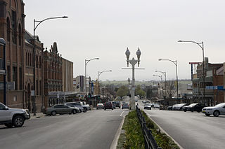
Orange is a city in the Central Tablelands region of New South Wales, Australia. It is 254 km (158 mi) west of the state capital, Sydney [206 km (128 mi) on a great circle], at an altitude of 862 metres (2,828 ft). Orange had an urban population of 41,920 at the 2021 Census, making the city a significant regional centre. A significant nearby landmark is Mount Canobolas with a peak elevation of 1,395 m (4,577 ft) AHD and commanding views of the district. Orange is situated within the traditional lands of the Wiradjuri Nation.
Broadcast Operations Group is an Australian media company, operating radio stations across various centres across regional New South Wales and Queensland, Australia. Branded as the Super Radio Network, stations carry one of two formats – a news talk and classic hits format based at 2SM Sydney; and a hot adult contemporary format based at New FM Newcastle.

The Lachlan River is an intermittent river that is part of the Murrumbidgee catchment within the Murray–Darling basin, located in the Southern Tablelands, Central West, and Riverina regions of New South Wales, Australia.

Cowra is a small town in the Central West region of New South Wales, Australia. It is the largest population centre and the council seat for the Cowra Shire, with a population of 9,863.

Mid-Western Highway, sometimes Mid Western Highway, is a 518-kilometre (322 mi) state highway located in the central western and northern Riverina regions of New South Wales, Australia. The highway services rural communities and links the Great Western, Mitchell, Olympic, Newell, Cobb and Sturt highways. Mid-Western Highway forms part of the most direct route road link between Sydney and Adelaide, with its eastern terminus in Bathurst and western terminus in Hay. It is designated part of route A41 between Bathurst and Cowra, and route B64 between Cowra and Hay.
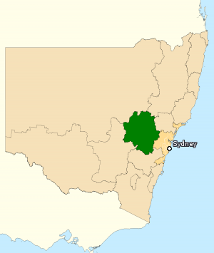
The Division of Calare is an Australian electoral division in the state of New South Wales.
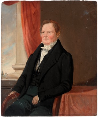
George William Evans was a surveyor and early explorer in the Colony of New South Wales. Evans was born in Warwick, England, migrating to Australia in October 1802.
Group 10 is a rugby league competition in the Central West area of New South Wales, under the auspices of the New South Wales Rugby League. It had been under the control of Country Rugby League but that changed after the NSWRL agreed to a new constitution and the CRL voted to wind up its affairs immediately. The decisions was made on 19 October 2019 and the merger means that the aim of a unified administration of the sport in NSW was achieved over a year ahead of time.

The Diocese of Bathurst (in Australia) is a Latin Church suffragan diocese of the Metropolitan Archdiocese of Sydney, established in 1865, covering the Central West and Orana regions of New South Wales, Australia.
Portland is a town in the Central Tablelands of New South Wales, Australia. At the 2016 census, Portland had a population of 2,424 people. The town was named after Australia's first cement works.

The Gwabegar railway line is a railway line in the Central West and North West Slopes of New South Wales, Australia, which passes through the towns of Mudgee, Gulgong, Dunedoo, Coonabarabran and terminates at Gwabegar.

The Central Tablelands in New South Wales is a geographic area that lies between the Sydney Metropolitan Area and the Central Western Slopes and Plains. The Great Dividing Range passes in a north–south direction through the Central Tablelands and includes the Blue Mountains. The region shares borders with the Hunter, Central West Slopes and Plains, South West Slopes, Southern Tablelands, North Western Slopes and Plains, the Sydney Metropolitan Area and the Illawarra.

Lachlan Valley Way is a New South Wales country road running from Booligal to north of Yass. It was named after the Lachlan River, and follows its southern bank for the majority of its length.
Central Ranges is a wine zone and Australian geographical indication in the Central West of New South Wales. It lies on the western slopes of the Great Dividing Range, west of the Blue Mountains.
The 2018 Group 10 Rugby League season was the 72nd season of premier competition of rugby league in the Central West area of New South Wales. It was run under the auspices of the Country Rugby League. It was the sixth consecutive season to feature nine teams, after the re-admittance of the Blayney Bears in 2013.
The 2019 Group 10 Rugby League season was the 73rd season of the premier rugby league competition in the Central West area of New South Wales. It was run under the auspices of the Country Rugby League. It was the seventh consecutive season to feature nine teams, after the re-admittance of the Blayney Bears in 2013.
Bathurst St Patrick's, more commonly referred to as St Pat's, are an Australian rugby league football team based in the Central West city of Bathurst. St Pat's have played in the Country Rugby League-controlled Group 10 Rugby League since the 1948, the competition's second season, winning six premierships, the most recent a 34–12 win over Cowra Magpies in 2014.
The Mid West Community Cup is a rugby league competition in the Central West area of New South Wales. The premiers are awarded the Blayney Citizens' Cup, the oldest continuously awarded trophy in Country Rugby League, with Neville the first recipients in 1913. For all intents and purposes, it is a third division competition in the Group 10/11 area.
The Western Premier League is a regional Australian association football league, comprising teams from the Central West region of New South Wales. The competition is run under the Western NSW Football body, an associate of Football NSW - a member federation of Football Australia. It fits below the national A-League and NSW wide divisions including National Premier Leagues NSW, being level 5 league in the Australian league system.