Peak Hill, New South Wales

Last updated

Peak Hill
New South Wales
Peak Hill welcome sign.jpg
Peak Hill - Town with a Heart of Gold
Australia New South Wales location map blank.svg
Red pog.svg
Peak Hill
Coordinates 32°43′S148°11′E / 32.717°S 148.183°E / -32.717; 148.183
Population768 (2021 census) [1]
Established1889 [2]
Postcode(s) 2869
Elevation285 m (935 ft)
Location
  • 409 km (254 mi) W of Sydney
  • 72 km (45 mi) SW of Dubbo
  • 49 km (30 mi) N of Parkes
LGA(s) Parkes Shire
State electorate(s) Orange
Federal division(s) Calare
Mean max tempMean min tempAnnual rainfall
24.6 °C
76 °F
12.0 °C
54 °F
561.4 mm
22.1 in

Peak Hill is a town in Parkes Shire in the Central West of New South Wales, Australia. At the 2021 census, Peak Hill had a population of 768 people. [1] It is located on the Newell Highway and the Parkes to Narromine railway line.

Contents

History

Before the arrival of Europeans, the Peak Hill area was part of the Wiradjuri people's lands. [3] In 1817, the explorer John Oxley and his party were the first Europeans in the region. [3] In 1889, Gold was discovered in the area, and later that year Peak Hill was gazetted in November 1889. [4] The Post office opened on 7 November 1889, and the Bureau of Meteorology's weather station began in 1965. [5] [6] The first public wheat silo built in Australia was constructed at Peak Hill in 1918 after government surveys indicated the district had great potential as a wheat-producing region. [7] [8]

Agriculture

The district is also a renowned sheep producing area, particularly medium-woolled merinos. There are also five merino studs actively operating in the area, namely Cora Lynn, Genanegie, Towalba, Towonga and Westray. Rams from these studs have been sold throughout Australia, and they all have on-property hoggett ram sales in September, supplying commercial sheep breeders with high-quality young rams to breed from.[ citation needed ]

Climate

Climate data for Peak Hill Post Office
MonthJanFebMarAprMayJunJulAugSepOctNovDecYear
Record high °C (°F)44.5
(112.1)
46.0
(114.8)
39.7
(103.5)
36.0
(96.8)
28.2
(82.8)
24.7
(76.5)
23.4
(74.1)
28.4
(83.1)
35.9
(96.6)
39.0
(102.2)
43.8
(110.8)
42.9
(109.2)
46.0
(114.8)
Mean daily maximum °C (°F)33.4
(92.1)
32.6
(90.7)
29.5
(85.1)
25.2
(77.4)
20.1
(68.2)
16.3
(61.3)
15.4
(59.7)
17.1
(62.8)
20.7
(69.3)
24.9
(76.8)
28.4
(83.1)
31.5
(88.7)
24.6
(76.3)
Mean daily minimum °C (°F)19.4
(66.9)
19.3
(66.7)
16.5
(61.7)
12.4
(54.3)
8.7
(47.7)
6.1
(43.0)
4.8
(40.6)
5.7
(42.3)
7.9
(46.2)
11.5
(52.7)
14.6
(58.3)
17.4
(63.3)
12.0
(53.6)
Record low °C (°F)7.4
(45.3)
7.8
(46.0)
4.3
(39.7)
1.5
(34.7)
−0.7
(30.7)
−2.5
(27.5)
−3.0
(26.6)
−3.6
(25.5)
−1.0
(30.2)
1.7
(35.1)
3.8
(38.8)
6.2
(43.2)
−3.6
(25.5)
Average rainfall mm (inches)58.9
(2.32)
50.3
(1.98)
50.5
(1.99)
41.8
(1.65)
44.3
(1.74)
43.3
(1.70)
44.4
(1.75)
42.3
(1.67)
39.1
(1.54)
48.0
(1.89)
47.4
(1.87)
51.5
(2.03)
561.4
(22.10)
Average rainy days (≥ 0.2mm)5.24.94.74.45.87.57.66.96.26.45.45.370.3
Source: Bureau of Meteorology [6]

Open Cut Mine

The Peak Hill Open Cut Experience is a self guided walk around the open cut mine. The walks follow signposted trails and the mine is fenced off for safety. Numerous information panels are located at the mines entry and long the paths at the various viewing platforms. A public toilet is located at the mine site. Relics from the early mining days are on display and the site is very popular with visitors of all ages.

Open Cut Mine Peak Hill Peak Hill Mine 2.jpg
Open Cut Mine Peak Hill

Facilities

Peak Hill has a Catholic primary school St Joseph's, and a public central school.

Peak Hill has three motels, one hotel and two caravan parks. It also has a post office, RSL club, bowling club, golf club, cafes, antique shops, newsagency, supermarket, butcher shop, art gallery, book shop, hairdressers and beauty salons. There is a showground that has harness races and an annual agricultural show.[ citation needed ]

Peak Hill offers many tourist attractions such as the open cut gold mine, flora and fauna reserve nature walk, Bogan Weir, Australia's first upright wheat silo, heritage listed hospital, arts and crafts, Big Fish fossil hut, and a unique street facade which takes visitors back in time.[ citation needed ]

The local community operates a volunteer-run radio station: PeakHillFM89.5. The station provides a round-the-clock service of classic hits seven days per week. [9]

Peak Hill styles itself as 'The Town With a Heart of Gold' [10] to reflect its proximity to the goldmine, and lends its facilities as a base for tourists of Wiradjuri Country.

Silos

Peak Hill's central position in the New South Wales wheat belt may have been the reason why Peak Hill became the site for Australia's first upright bulk wheat silo in 1918. [11] It was not until 1927 that the next stage, the six-bin silos and weighbridge complex, was completed at Peak Hill. In 1950 the construction of three additional 50,000-bushel bins was carried out and the bulkhead was completed in 1959.

After viewing the current silo, it will become apparent that they have grown substantially over the years to cope with the local grain production. A lot of locally grown grain is also taken over to the Parkes silo.

The Peak Hill silo can be viewed from Lindner Avenue, which runs parallel with the railway line.

Peak Hill Silo Peak Hill Silo.jpg
Peak Hill Silo

War memorials

Peak Hill has a war memorial at the Peak Hill Cemetery located north of the town on the Newell Highway.

There is also the AIF War Memorial School of Arts, the War Memorial park, and the War Memorial Pool.


War Memorial Peak Hill War Memorial Peak Hill.jpg
War Memorial Peak Hill

Places to see

Recreation areas

Arts and crafts

Many arts and crafts are represented in the community.

Notable people

Related Research Articles

<span class="mw-page-title-main">Parkes, New South Wales</span> Town in New South Wales, Australia

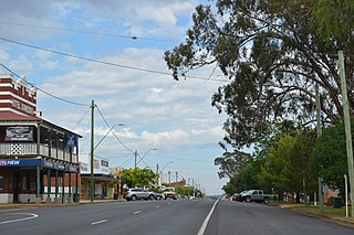
Parkes is a town in the Central West region of New South Wales, Australia. It is the main settlement in the local government area of Parkes Shire. Parkes has a population of 10,919 at the 2021 census.

<span class="mw-page-title-main">Orange, New South Wales</span> City in New South Wales, Australia

Orange is a city in the Central Tablelands region of New South Wales, Australia. It is 254 km (158 mi) west of the state capital, Sydney [206 km (128 mi) on a great circle], at an altitude of 862 metres (2,828 ft). Orange had an urban population of 41,920 at the 2021 Census, making the city a significant regional centre. A significant nearby landmark is Mount Canobolas with a peak elevation of 1,395 m (4,577 ft) AHD  and commanding views of the district. Orange is situated within the traditional lands of the Wiradjuri Nation.

<span class="mw-page-title-main">Narromine</span> Town in New South Wales, Australia

Narromine (/næroʊmaɪn/) is a rural Australian town located approximately 40 kilometres (25 mi) west of Dubbo in the Orana region of New South Wales. The town is at the centre of Narromine Shire. The 2016 census recorded a population of 3,528. Narromine holds strong historical ties to the Australian Military, as it was the location of RAAF No.19 Inland Aircraft Fuel Depot (IAFD) during World War II. The base contributed to the preparation of troops through a training organisation known as the Empire Air Training Scheme (EATS). The town was one of twelve locations for the No.5 Elementary Flying Training School RAAF in 1940.

<span class="mw-page-title-main">Macquarie River</span> River in New South Wales, Australia

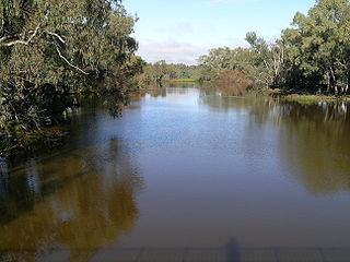
The Macquarie River or Wambuul is part of the Macquarie–Barwon catchment within the Murray–Darling basin, is one of the main inland rivers in New South Wales, Australia.

<span class="mw-page-title-main">Dunedoo</span> Town in New South Wales, Australia

Dunedoo is a village of 1,021 inhabitants situated within the Warrumbungle Shire of central western New South Wales, Australia. Dunedoo is well known to Australian travellers due to its distinctive name. The name is actually derived from a local Aboriginal word meaning "swan", which are commonly found in the area's lagoons.

<span class="mw-page-title-main">Bogan River</span> River in Australia

Bogan River, a perennial river that is part of the Macquarie–Barwon catchment within the Murray–Darling basin, is located in the central west and Orana regions of New South Wales, Australia.

<span class="mw-page-title-main">Narrandera</span> Town in New South Wales, Australia

Narrandera, until around 1949 also spelled "Narandera", is a town located in the Riverina region of southern New South Wales, Australia. The town lies on the junction of the Newell and Sturt highways, adjacent to the Murrumbidgee River, and it is considered the gateway to the Murrumbidgee Irrigation Area. At the 2016 census, Narrandera had a population of 3,746 people.

<span class="mw-page-title-main">Thomas Axford</span> Australian recipient of the Victoria Cross (1894–1983)

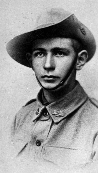
Thomas Leslie "Jack" Axford, was an Australian recipient of the Victoria Cross, the highest award for gallantry in the face of the enemy awarded to British and Commonwealth forces.

<span class="mw-page-title-main">Neville Howse</span> Australian Army general, politician, and recipient of the Victoria Cross

Major General Sir Neville Reginald Howse, was an Australian Army officer, medical doctor, and politician. He was the first Australian recipient of the Victoria Cross (VC), the highest decoration for gallantry "in the face of the enemy" that can be awarded to members of the British and Commonwealth armed forces.

<span class="mw-page-title-main">Arthur Hall (soldier)</span>

Arthur Charles Hall, VC was an Australian recipient of the Victoria Cross, the highest award for gallantry in the face of the enemy that can be awarded to British and Commonwealth forces. His Victoria Cross was won for his actions in September 1918 on the Western Front during the First World War.

<span class="mw-page-title-main">Cootamundra</span> Town in New South Wales, Australia

Cootamundra, nicknamed Coota, is a town in the South West Slopes region of New South Wales, Australia and within the Riverina. It is within the Cootamundra-Gundagai Regional Council. At the 2016 Census, Cootamundra had a population of 6,782. It is located on the Olympic Highway at the point where it crosses the Muttama Creek, between Junee and Cowra. Its railway station is on the Main Southern line, part of the Melbourne-to-Sydney line.

<span class="mw-page-title-main">West Wyalong</span> Town in New South Wales, Australia

West Wyalong is the main town of the Bland Shire in the Riverina region of New South Wales, Australia. Located 467 kilometres (290 mi) west of Sydney as well as being 262 m (860 ft) above sea level, it is situated on the crossroads of the Newell Highway between Melbourne and Brisbane, and the Mid-Western Highway between Sydney and Adelaide.

<span class="mw-page-title-main">Karoonda, South Australia</span> Town in South Australia

Karoonda is a town in the middle of the Murray Mallee region of South Australia. The current boundaries include the former town of Lowaldie, which was the next stop on the railway line away from Adelaide.

<span class="mw-page-title-main">Grenfell, New South Wales</span> Town in New South Wales, Australia

Grenfell is a town in Weddin Shire in the Central West of New South Wales, Australia. It is 370 km (230 mi) west of Sydney. It is close to Forbes, Cowra and Young. At the 2011 census, Grenfell had a population of 1,996. The town is served daily by connecting NSW TrainLink services from Sydney via Bathurst and Lithgow. Grenfell is approximately 5 hours from Sydney and 2+12 hours from Canberra.

<span class="mw-page-title-main">Condobolin</span> Town in New South Wales, Australia

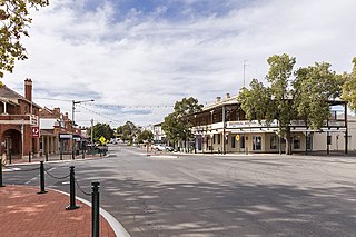
Condobolin is a town in the west of the Central West region of New South Wales, Australia, on the Lachlan River. At the 2021 census, Condobolin had a population of 3,185.

<span class="mw-page-title-main">Ariah Park</span> Town in New South Wales, Australia

Ariah Park is a small town in the Riverina region of New South Wales, Australia, 35 kilometres (22 mi) west of Temora and 65 kilometres (40 mi) south of West Wyalong. The town is within the Temora Shire near Burley Griffin Way. On Census night 2011, Ariah Park had a population of 268 people. The town is listed by the National Trust as a Conservation Area.

<span class="mw-page-title-main">Bogan Gate</span> Town in New South Wales, Australia

Bogan Gate is a small village in Parkes Shire of the Central West of New South Wales, Australia. At the 2011 census, Bogan Gate and the surrounding area had a population of 307. Bogan Gate is derived from the local Aboriginal word meaning "the birthplace of a notable headman of the local tribe".

<span class="mw-page-title-main">Murrumburrah</span> Town in New South Wales, Australia

Murrumburrah is a township in New South Wales, Australia, part of a twin town with Harden. The town is in Hilltops Council local government area in the South West Slopes area of NSW. It is on the Burley Griffin Way, the major link from the Riverina to the Hume Highway near Yass, and ultimately Sydney, Canberra and the coast.

Alec Jeffrey Hill was an Australian military historian and academic best known for his biography of General Sir Harry Chauvel and his work on the Australian Dictionary of Biography.

Trewilga is a bounded rural locality in Parkes Shire, within the Central West region of New South Wales, Australia. There was once a village and railway station of the same name. Prior to 1913, the village was known as Mingelo.

References

  1. 1 2 Australian Bureau of Statistics (27 June 2017). "Peak Hill (Urban Centre/Locality)". 2016 Census QuickStats. Retrieved 9 April 2015. OOjs UI icon edit-ltr-progressive.svg
  2. "Government Gazette Proclamations and Legislation". New South Wales Government Gazette . No. 630. New South Wales, Australia. 30 November 1889. p. 8528. Retrieved 25 April 2019 via National Library of Australia.
  3. 1 2 "Peak Hill History". Peak Hill NSW. Peak Hill Visitor Information Centre. Retrieved 27 April 2019.
  4. "Government Gazette Proclamations and Legislation". New South Wales Government Gazette . No. 630. New South Wales, Australia. 30 November 1889. p. 8528. Retrieved 27 April 2019 via National Library of Australia.
  5. "Peak Hill Post Office" . Retrieved 18 February 2021.
  6. 1 2 "Peak Hill Post Office". Climate statistics for Australian locations. Bureau of Meteorology. April 2019. Retrieved 27 April 2019.
  7. "A History of Peak Hill and District", published by the Peak Hill Centenary book committee, 1989.
  8. "Peak Hill Silos mark 100 years". Parkes Shire Council. Retrieved 27 April 2019.
  9. "Peakhillfm 89:5" . Retrieved 18 February 2021.
  10. "Town with a Heart of Gold" . Retrieved 29 May 2015.
  11. "This silo is special, even though it has no mural". ABC News. 27 August 2019. Retrieved 8 May 2022.
  12. "Hanley, Kitty (Kate) (c. 1845–1917)". Australian Dictionary of Biography.
  13. "Sergeant George Brayne". Billion Graves.
  14. "George Brayne". Australian Police.
  15. "Frost, Charles Leslie (1897–1971)". Australian Dictionary of Biography, National Centre of Biography, Australian National University.
  16. "Frost, Charles Leslie (1897–1971)". Australian Dictionary of Biography, National Centre of Biography, Australian National University.