Yass Valley Council is a local government area in the Southern Tablelands region of New South Wales, Australia. The area is located adjacent to the Hume and Barton Highways and the Main Southern railway line.
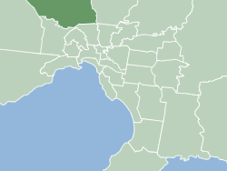
The City of Hume is a local government area located within the metropolitan area of Melbourne, Victoria, Australia. It includes the outer north-western suburbs and a number of rural localities between 13 and 40 kilometres from the Melbourne city centre.

The Surf Coast Shire is a local government area in the Barwon South West region of Victoria, Australia, located in the south-western part of the state. It covers an area of 1,553 square kilometres (600 sq mi). It had a population of 32,251 in June 2018. It includes the towns of Aireys Inlet, Anglesea, Lorne, Moriac, Torquay and Winchelsea. It was formed in 1994 from the amalgamation of the Shire of Winchelsea, Shire of Barrabool and part of the former City of South Barwon, which was, at that point, part of the City of Greater Geelong.
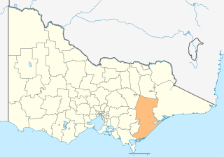
The Shire of Wellington is a local government area in Victoria, Australia, located in the eastern part of the state. It covers an area of 10,817 square kilometres (4,176 sq mi) and in June 2018 had a population of 44,019.

The City of Hawkesbury is a local government area of New South Wales, Australia, located on the northern and north-western fringe of the Greater Sydney area, about 50 kilometres (31 mi) north-west of the Sydney central business district. Hawkesbury City is named after the Hawkesbury River. Major towns in City of Hawkesbury are Windsor, Richmond and Pitt Town.

The Warrumbungle Shire is a local government area in the central western region of New South Wales, Australia. The Shire is traversed by the Newell Highway. The Warrumbungle mountain range and Warrumbungles National Park are major tourist attractions for the Shire. Its seat is located in Coonabarabran, a town in the southwest.

Greater Hume Shire is a local government area in the Riverina region of southern New South Wales, Australia. The Shire was formed in 2004 incorporating Culcairn Shire, the majority of Holbrook Shire and part of Hume Shire. The shire had an estimated population of 10,137 as at 2012.

Gwydir Shire is a local government area located in the New England region of New South Wales, Australia. The northern boundary of the Shire is located adjacent to the border between New South Wales and Queensland.

Narromine Shire is a local government area in the Orana region of New South Wales, Australia. The Shire is located adjacent to the Mitchell Highway and the Main Western railway line. It was formed on 1 January 1981 from the amalgamation of the Municipality of Narromine and Timbrebongie Shire resulting from the Local Government Areas Amalgamation Act 1980.

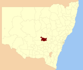
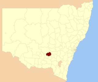
The Mid-Western Regional Council is a local government area in the Central West region of New South Wales, Australia. The area is located adjacent to the Castlereagh Highway that passes through the middle of the area in an approximate southeast–northwest direction.

Cabonne Council is a local government area in the Central West region of New South Wales, Australia. The Shire is located adjacent to the Mitchell Highway and the Broken Hill railway line, partly surrounding the City of Orange. The administrative centre is located at Molong.

Berrigan Shire is a local government area in the southern Riverina region of New South Wales, Australia. The Shire lies on the New South Wales State border with Victoria formed by the Murray River. The Shire is adjacent to the Newell and Riverina Highways. The Shire is a mainly agricultural region, with dairying, cattle raising, woolgrowing and cropping the main activities. The vast majority of the Shire is irrigated. Tourism is another major activity, concentrated on the river towns of Tocumwal and Barooga.

Narrabri Shire is a local government area in the North West Slopes region of New South Wales, Australia. The Shire is located adjacent to the Namoi River and the Newell and Kamilaroi Highways.

The Junee Shire is a local government area in the Riverina region of New South Wales, Australia. The Shire comprises an area of 2,030 square kilometres (780 sq mi) and is located adjacent to the Olympic Highway and the Main South railway line. It was formed on 1 January 1981 from the amalgamation of the Municipality of Junee and Illabo Shire resulting from the Local Government Areas Amalgamation Act 1980.
Temora Shire is a local government area in the Riverina region of New South Wales, Australia. It is on Burley Griffin Way. The Shire was created on 1 January 1981 via the amalgamation of Narraburra Shire and the Municipality of Temora.

Narrandera Shire is a local government area in the Riverina region of south-western New South Wales, Australia. The Shire is located adjacent to the Sturt and Newell Highways.

Coonamble Shire is a local government area in the Orana region of New South Wales, Australia. The Shire is located adjacent to the Castlereagh Highway and the Castlereagh River.

Warren Shire is a local government area in the Orana region of New South Wales, Australia. The Shire is located adjacent to the Macquarie River and the Mitchell and Oxley Highways. The use of the area is mainly for wool and cotton growing.

The Fraser Coast Region is a local government area in the Wide Bay–Burnett region of Queensland, Australia, about 250 kilometres (160 mi) north of Brisbane, the state capital. It is centred on the twin cities of Hervey Bay and Maryborough and also contains K'gari. It was created in 2008 from a merger of the Cities of Maryborough and Hervey Bay and the Shires of Woocoo and most of Tiaro. The resident population at the 2021 census was 111,032 and the estimated population in 2023 was 117,940.

Murrumbidgee Council is a local government area in the Riverina region of New South Wales, Australia. This area was formed in 2016 from the merger of the Murrumbidgee Shire and the Jerilderie Shire.