Oberon New South Wales | |||||||||
---|---|---|---|---|---|---|---|---|---|
Coordinates | 33°43′S149°52′E / 33.717°S 149.867°E | ||||||||
Population | 3,319 (2021 census) [1] | ||||||||
Postcode(s) | 2787 | ||||||||
Elevation | 1,113 m (3,652 ft) | ||||||||
Location | |||||||||
LGA(s) | Oberon Council | ||||||||
County | Westmoreland | ||||||||
State electorate(s) | Bathurst | ||||||||
Federal division(s) | Calare | ||||||||
|
Oberon is a town located within the Oberon Council local government area, in the central tablelands region of New South Wales, Australia. The main industries are farming, forestry and wood products. The town usually receives snowfall during the winter months, owing to its high elevation. At the 2021 census, Oberon had a population of 3,319 people. [1]
It is the birthplace of Greens politician Bob Brown, Ken Sutcliffe, supermotard rider Scott Saul, former Penrith Panthers players Ray Blacklock, Mark Booth, Dr Therese Wales and DJ Tallis O’Neill. Oberon is located near Jenolan Caves and the Kanangra-Boyd National Park.
The town was permanently settled in 1839, originally named Bullock Flat, until it was renamed to Oberon in 1863. Gold was discovered on the Fish River in 1823, leading to a population boost in the area. The Oberon Council was formed in 1906. [2] The Fish River Creek Post Office opened on 1 January 1855 and was renamed Oberon in 1866. [3]
Oberon has a number of heritage-listed sites, including:
Oberon's main streets are Carrington Avenue–Oberon Street and Ross Street. The town has several parks and sports facilities. Such parks include the Oberon Showground, Cunynghame Oval, and Apex Park. Oberon also has a museum on North Street. Oberon has a caravan park on Cunynghame Street off North Street, a hospital on North Street, a camping ground adjacent to the caravan park and a wood gallery on Oberon Street. Rotary Lookout is located on Abercrombie Road and to the east of the town is the Blenheim State Forest which includes walking tracks.
Fishing is a pastime possible at Lake Oberon and The Reef Reserve. Oberon also has a golf club off Hume Street.
The inaugural Oberon Chamber Music Festival is planned for November 2023, with performances in the Common, and at the Malachi.
Oberon is known for its two inns, the Big Trout Motor Inn and the Highlands Motor Inn.
South of the town is Lake Oberon, Oberon Dam and the Fish River. There is a picnic area at the dam and a reserve with walking tracks near the lake.
Rugby league football coach Craig Bellamy started his playing career with Oberon Tigers team in the 1970s. [8]
Mayfield Garden is a popular botanical garden that covers 16 hectares (40 acres) of land. It is open daily, except on public holidays and there is an entry fee.
Jillaroo turned interior designer, fashionista and active wear entrepreneur Rachael Challinor spent her formative years in Oberon before moving to Sydney. Known for her sometimes abrasive and outspoken views, she credits the town's Big Trout as a key source of influence on her prolific artistic and creative works in her later years.
From 1923 to 1979, Oberon was served by a branch railway line noted for its very steep 4% gradients and very sharp 100 m radius curves. [9] Following closure, that line was allowed to fall into disrepair, but has been under restoration by the volunteer organisation Oberon Tarana Heritage Railway since 2005. [10]
From 1 June 2020, there is a Monday to Friday morning bus service to Tarana station where it connects with the Bathurst Bullet train to Sydney Central with an afternoon return connection. This replaced the previous Tuesday, Friday, and Sunday coach service to Mount Victoria [12] [13]
While the Fentons operated Trainlink service ran on public holidays, the current system does not. As a further inconvenience, connection to the evening bus requires departure from Sydney around 3 pm, rather than after 5:17 pm.
Weekday bus services to Bathurst are operated by Newmans, which connect with several other Trainlink rail and coach services, and with local buses.
Oberon has an oceanic climate ( Cfb ); with mild to warm summers, cool to cold winters averaging 0° to 9 °C and evenly-spread precipitation throughout the year. Frosts occur regularly in autumn, winter and spring, and can also occur at the height of summer. Because of its elevation and windward position on the dividing range, moderate to occasionally heavy snowfalls can be expected each year. Records ceased in 2020 due to negligence by the Bureau.
Climate data for Oberon (Albion St, 1946–2020, rainfall to 1888); 1,088 m AMSL; 33.70° S, 149.87° E | |||||||||||||
---|---|---|---|---|---|---|---|---|---|---|---|---|---|
Month | Jan | Feb | Mar | Apr | May | Jun | Jul | Aug | Sep | Oct | Nov | Dec | Year |
Record high °C (°F) | 36.9 (98.4) | 38.6 (101.5) | 32.6 (90.7) | 28.1 (82.6) | 23.1 (73.6) | 17.1 (62.8) | 16.8 (62.2) | 20.2 (68.4) | 25.6 (78.1) | 30.1 (86.2) | 35.3 (95.5) | 37.9 (100.2) | 38.6 (101.5) |
Mean daily maximum °C (°F) | 25.1 (77.2) | 23.9 (75.0) | 21.5 (70.7) | 17.3 (63.1) | 13.2 (55.8) | 9.5 (49.1) | 8.8 (47.8) | 10.4 (50.7) | 13.8 (56.8) | 17.2 (63.0) | 20.1 (68.2) | 23.3 (73.9) | 17.0 (62.6) |
Mean daily minimum °C (°F) | 11.1 (52.0) | 11.2 (52.2) | 9.1 (48.4) | 5.5 (41.9) | 2.6 (36.7) | 0.9 (33.6) | −0.3 (31.5) | 0.4 (32.7) | 2.3 (36.1) | 4.8 (40.6) | 6.8 (44.2) | 9.1 (48.4) | 5.3 (41.5) |
Record low °C (°F) | −0.5 (31.1) | 1.7 (35.1) | −2.2 (28.0) | −4.0 (24.8) | −6.3 (20.7) | −8.5 (16.7) | −8.7 (16.3) | −7.2 (19.0) | −5.8 (21.6) | −3.5 (25.7) | −2.5 (27.5) | −3.0 (26.6) | −8.7 (16.3) |
Average precipitation mm (inches) | 80.1 (3.15) | 60.9 (2.40) | 65.7 (2.59) | 57.3 (2.26) | 59.7 (2.35) | 78.5 (3.09) | 70.6 (2.78) | 74.5 (2.93) | 67.2 (2.65) | 77.8 (3.06) | 71.5 (2.81) | 74.6 (2.94) | 838.4 (33.01) |
Average precipitation days (≥ 0.2 mm) | 7.9 | 7.5 | 7.9 | 7.8 | 9.0 | 11.7 | 11.1 | 10.8 | 9.6 | 9.5 | 8.1 | 7.7 | 108.6 |
Source: [14] |
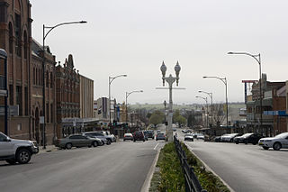
Bathurst is a city in the Central Tablelands of New South Wales, Australia. Bathurst is about 200 kilometres (120 mi) west-northwest of Sydney and is the seat of the Bathurst Regional Council. Bathurst is the oldest inland settlement in Australia and had a population of 37,191 in June 2019.
Richmond is a town in New South Wales, in the local government area of the City of Hawkesbury. It is located 19 metres above sea level on the alluvial Hawkesbury River flats, at the foot of the Blue Mountains on the Cumberland Plain. It is about 65 km by road from Sydney and about 78 km by road from Lithgow.
Windsor is a historic town in north-west of Sydney, New South Wales, Australia. It is the council seat of the Hawkesbury local government area. The town sits on the Hawkesbury River, enveloped by farmland and Australian bush. Many of the oldest surviving European buildings in Australia are located at Windsor. It is 46 km (29 mi) north-west of the Sydney CBD, on the fringes of urban sprawl.
Lithgow is a town in the Central Tablelands of New South Wales, Australia and is the administrative centre of the City of Lithgow local government area. It is located in a mountain valley named Lithgow's Valley by John Oxley in honour of William Lithgow, the first Auditor-General of New South Wales.
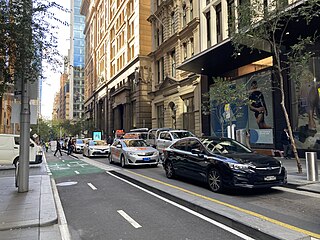
Pitt Street is a major street in the Sydney central business district in New South Wales, Australia. The street runs through the entire city centre from Circular Quay in the north to Waterloo, although today's street is in two disjointed sections after a substantial stretch of it was removed to make way for Sydney's Central railway station. Pitt Street is well known for the pedestrian only retail centre of Pitt Street Mall, a section of the street which runs from King Street to Market Street.
Glenbrook is a township of the Lower Blue Mountains of New South Wales, Australia. It is located 63 kilometres west of the Sydney central business district, in the local government area of the City of Blue Mountains. As of the 2021 Australian census Glenbrook had a population of 5,078 people.
Tarana is a small town in the Central West of New South Wales, Australia in the City of Lithgow.
Linden is a village in the Blue Mountains of New South Wales, Australia. It is in the City of Blue Mountains, 82 km west of Sydney and 23 km east of Katoomba. The village is on the Great Western Highway and has a railway station on the Main Western railway line served by NSW TrainLink's Blue Mountains Line. It shares a post office, and therefore the 2778 postcode, with adjoining Woodford. In the 2011 census, its population was 594, including 19 indigenous people (3.2%).
The City of Blue Mountains is a local government area of New South Wales, Australia, governed by the Blue Mountains City Council. The city is located in the Blue Mountains, on the Great Dividing Range at the far western fringe of the Greater Sydney area.
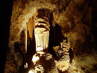
The Jenolan Caves are limestone caves located within the Jenolan Karst Conservation Reserve in the Central Tablelands region, west of the Blue Mountains, in Jenolan, Oberon Council, New South Wales, in eastern Australia. The caves and 3,083-hectare (7,620-acre) reserve are situated approximately 175 kilometres (109 mi) west of Sydney, 20 kilometres (12 mi) east of Oberon and 30 kilometres (19 mi) west of Katoomba. Dating back to 340million years ago, it is the oldest known and dated open cave system in the world.
North Sydney Council is a local government area on the Lower North Shore of Sydney, New South Wales, Australia, established on 29 July 1890 through the amalgamation of three boroughs.
Hartley is a historical village in the Central West region of New South Wales, Australia, within the City of Lithgow local government area, located approximately 127 kilometres (79 mi) west of Sydney. Hartley is located below the western escarpment of the Blue Mountains.
The City of Lithgow is a local government area in the Central West region of New South Wales, Australia. The area is located adjacent to the Great Western Highway and the Main Western railway line.
Oberon Council is a local government area in the Central West region of New South Wales, Australia.
East Maitland is a suburb in Maitland, New South Wales, Australia. It is on the New England Highway and it has two railway stations, Victoria Street and East Maitland. Both stations are served by NSW TrainLink. Hunter Valley Buses provides bus service.
Bowenfels is a small town on the western outskirts of Lithgow, New South Wales, Australia.
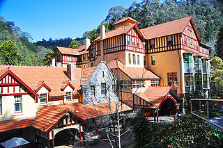
The Jenolan Caves House is a large, heritage-listed hotel, built in stages between 1879 and 1926. It is located in the remote Jenolan Caves Karst Conservation Reserve, Blue Mountains National Park, on the western edge of the Blue Mountains UNESCO World Heritage Area, in New South Wales, Australia.
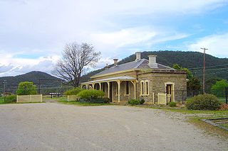
Rydal railway station is a heritage-listed railway station located on the Main Western line in Rydal, City of Lithgow, New South Wales, Australia. It is also known as Rydal Railway Station group. The property was added to the New South Wales State Heritage Register on 2 April 1999.
Tarana railway station is a heritage-listed railway station located on the Main Western line in Tarana, City of Lithgow, New South Wales, Australia. It is also known as the Tarana Railway Station and yard group. The property was added to the New South Wales State Heritage Register on 2 April 1999.
Georges Plains is a locality in the Bathurst Region of New South Wales, Australia. It had a population of 248 people as of the 2016 census.
Media related to Oberon, New South Wales at Wikimedia Commons