Rylstone, New South Wales

Last updated

Rylstone
New South Wales
St Malachy's Rylstone NSW.jpg
St Malachy's Church Rylstone
Australia New South Wales location map blank.svg
Red pog.svg
Rylstone
Coordinates 32°48′S149°58′E / 32.800°S 149.967°E / -32.800; 149.967
Population904 (2021 census) [1]
Postcode(s) 2849
Elevation582 m (1,909 ft)
Location
LGA(s) Mid-Western Regional Council
State electorate(s) Bathurst
Federal division(s) Calare
Mean max tempMean min tempAnnual rainfall
23.0 °C
73 °F
8.3 °C
47 °F
675 mm
26.6 in

Rylstone is a small town in New South Wales, Australia, in the Central Tablelands region within the Mid-Western Regional Council local government area. It is located on the Bylong Valley Way road route. At the 2021 census, Rylstone had a population of 904. [1]

Contents

Etymology

The name 'Rylstone' has no clear origin; however, several possible origins are promoted. [2]

A petition was sent to Governor Gipps asking for a village to be called Tong Bong to be established at the present site of Rylstone. Governor Gipps granted permission for the village to be surveyed but he insisted that the village be called Rylstone and not Tong Bong. There is no evidence of any connection between Governor Gipps and the English village of Rylstone. [2]

Early maps spell Rylstone as Rylestone.

Rylstone Street Map Rylstone-street map.png
Rylstone Street Map

Exploration

Several early explorers and settler explorers travelled this area in the early 1800s; they include Samuel Marsden, Macquarie, Edward Cox, James Blackman Jr., [3] Jamison, FitzGerald, John Nevell and James Vincent. [2] Several mountains in the area commemorate their journeys through the Glen Alice Valley and up the Turon River. [2] James Blackman jnr. explored a route from Bathurst to the Cudgegong River and present site of Rylstone in 1820. [4] Allan Cunningham, the botanist and explorer, on his first expedition to find a route from Bathurst to the Liverpool Plains noted in his diary in November 1822 being in the Tabrabucka area and on the second expedition 18 April 1823 passing through Dabee (now Rylstone). [5]

View from MtCoombermellon.jpg
from Mount Coombermellon (locally known as Baldy) looking over Kandos and Rylstone

History

The district was originally known as Dabee (under various spellings). There are many contemporary newspaper references to the town being referred to as Ryalston in the period 1846 to mid-1850s [6] then referred to as Ryalstone during the late 1850s. [7] Rylstone town was laid out in 1846 by surveyor Davidson. By the 1850s Rylstone was becoming a well established town with post office, hotels, school, mills, and police lock-up. The Rylstone district was declared as a police district in 1854. [8] Rylstone was formally proclaimed a town on 20 March 1885. [2]

Railway

Rylstone railway station in 2011 Rylstone Railway Station, NSW 2.jpg
Rylstone railway station in 2011

On 9 June 1884 the railway was opened to Rylstone, [9] this changed the status of Rylstone village to that of a town. The railway yard included a goods shed, trucking yards, and turntable. [2] Notably, Henry Lawson's father, Niels Hertzberg Larsen, helped build the timber Rylestone railway station. The line was extended from Rylstone to Mudgee and this section was opened on 10 September 1884. Rylstone is located on the Gwabegar railway line.

In April 1895 a railway telephone line was installed between Wallerawang and Mudgee with Rylstone as an intermediate telephone point. The telephone was an important safety feature on this railway due to the steep cliffs and tunnels that occur on both sides of Rylstone allowing quick and clear communication of problems. [10]

The railway line through Rylstone was closed on 2 March 1992 and remain closed for eight years. [11] The NSW Government spent $11 million to resleeper the track, repair bridges, and level crossings reopening the line on 2 September 2000, [12] the line was again closed seven years later on 30 June 2007, the line remains closed; however, there are plans to reopen the line for coal trains to operate between Cobbora Mine (near Dunedoo) and the Mount Piper Power Station and Wallerawang Power Station. [13] [14]

On 24 October 2017 the NSW State Government announced that $1.1 million would be provided to reinstate the eight kilometre rail link between Kandos and Rylstone, thus enabling tourist trains to access the resulting 'Kandos-Rylstone Rail Heritage Precinct'. Refurbishment work, which includes replacing 3,500 old timber sleepers with long-life steel, is expected to commence in April 2018 and continue for six months. [15]

Rylstone Bridge during construction in 1948. Rylstone Bridge 1948.jpg
Rylstone Bridge during construction in 1948.

Bridges

Four road bridges have spanned the Cudgegong River which flows through the town. The first bridge was a suspension bridge that was washed away by floods around 1867. This was followed by a second bridge of two spans built by a Mr Hayden soon after the flood. This second bridge was alongside the first bridge at the end of Hall Street. A third bridge built by Eddy Fitzgerald replaced the second in 1890 and was a little further up the River. The fourth bridge, and the only one remaining, which is still used today was built in 1948 to line up with the Bylong Road. A railway bridge also spans the Cudgegong River approximately 100 metres upriver of the present road bridge. This apart from upgrading works, to add additional centre pillars, is the original structure built during the construction of the line. [2]

Hotels

By 1868 there were four Hotels, the Rylstone Hotel, Bridge View, Shamrock and the Globe. [2] The Rylstone and Globe Hotels remain in business. The Shamrock Hotel was located on the southern side of the railway bridge and was built by Michael Hayes in 1885 closing in 1890. [2]

The Globe Hotel The Globe Hotel, 1880, Rylstone, NSW, Australia (angle 3).jpg
The Globe Hotel
The Rylstone Hotel The Rylstone Hotel, Rylstone, NSW, Australia.jpg
The Rylstone Hotel

Aboriginal history

The local indigenous Aboriginals were the Dabee tribe and they in turn were part of the broader Wiradjuri group of people. Some of the localities in the area are derivations of Aboriginal words. [2]

One of the last full blooded Aborigines of the Rylstone area was Peggy Lambert wife of Jimmy Lambert, she was buried in the Aboriginal section of the Rylstone Cemetery in June 1884. [17] Another local Aboriginal was Jimmy McDonald who was attached to the Rylstone Police station as a tracker. [2]

Early settlers and properties

[2]

  • Richard Fitzgerald 1772–1840 (of Dabee Station) – an Irish political prisoner who became an emancipist
  • Robert Fitzgerald (son of Richard) 1807–1865
  • Edward Cox (of Rawdon Station)
  • Daniel Cox (of Balmoral, Nullo Mountain) – Daniel Cox sailed from England as a convict on 16 August 1830
  • John Nevell (of the property Carwell)
  • John Thompson 1796–1873 and son William Barber Thompson 1821–1889 (Davis Swamp Holding, later named Olinda)
  • Harry Thompson (of Warleigh to become Woodlands, near Nullo Mountain) no relation to the above Thompsons
  • Thomas Harris (of Loowee, property that later became Lue and Monivae)

Buildings and businesses

Early buildings were constructed of timber slabs and stringy bark, later wattle and daub became common. Plentiful sandstone in the area led to significant buildings being constructed of that material. [2]

The main commercial street, Louee Street, was originally an upper level and lower level street. In the 1930s the street was levelled and this created the high steps to the buildings on the high side of the road. [2]

Other events in Rylstone history

Bridge View Inn BridgeViewInn-RylstoneNSW.jpg
Bridge View Inn
Post & Telegraph Office Post and Telegraph Office, 1880, Rylstone, NSW, Australia.jpg
Post & Telegraph Office
Court House Court House, 1872, Rylstone, NSW, Australia (angle).jpg
Court House
Wesleyan Church Wesleyan Church, 1884, Rylstone, NSW, Australia (angle 2).jpg
Wesleyan Church
  • 1849 – Post Office opened on 1 January 1849. [18]
  • 1853 – Wesleyan Chapel opened on Sunday 15 May 1853 [19]
  • 1857 – laying of foundation stone for new church, St James Rylstone on 19 May 1857 [20]
  • 1857 – The School opened in July 1857. [18]
  • 1875 – Rylstone and district population was approximately 300 persons [21]
  • 1879 – Dr Dame Constance D'Arcy, a leading Sydney obstetrician and gynaecologist, born in Rylstone.
  • 1880 – Telegraph Office was built and the Post Office relocated to this building [2]
  • 1894 – Gold discovered in Rylstone area, gold showing freely through reef, a gold rush results, 21 August 1894 [22]
  • 1897 – A 70 oz gold nugget was found between Stony Pinch and Appletree Flat [23]
  • 1899 – Rylstone and other nearby towns promote themselves as a suitable site for the new Federal Capital [24] [25] [26]
  • 1903 – Coal was discovered for the first time by New Zealand mining company at Coomber (5 miles south of Rylstone) [27]
  • 1906 – A telephone line was opened between Rylstone and Mudgee, 1 February 1906 [28]
  • 1907 – Iron and Steel manufacturing works proposed for Rylstone [29]
  • 1914 – A 50 line telephone switchboard was opened at Rylstone on 28 October [30] [31]
  • 1915 – in April 1915 a new telephone line was constructed between Rylstone and Bylong [32]
  • 1915 – Tenders accepted for construction of a new hospital at Rylstone, £1723, 27 April 1915 [33]
  • 1924 – A new direct telephone trunk line was built from Lithgow to Rylstone and on to Mudgee, prior to this date all calls to Sydney were connected via Switchboards at Rylstone, Mudgee, Bathurst then Sydney [34]
  • 1925 – The Rylstone school is destroyed by fire during school hours, no one is hurt, 6 August 1925 [35]
  • 1925 – The Standard Portland Cement Company's Kandos Cement Works are under construction [36]
  • 1926 – An electrification scheme commenced for the towns of Rylstone and Kandos, power being supplied by the Kandos Cement Works, connection switched on in November 1926. [37] [38]
  • 1926 – record rainfall of 1250 points (317mm) falling in a week (rain commencing 25 March 1926), washing out the Tong Bong crossing [39]
  • 1931 – Rich Shale Oil discovery at Rylstone [40]
  • 1935 – Hospital additions, new wing and nurses quarters were opened by Minister for Health on 3 August 1935, costing £1700 [41]
  • 1938 – Discussions with NSW Government commenced on provided a water supply scheme for Rylstone. [42]
  • 1954 – A water supply dam was completed and pipes were installed to connect the town to running water [2]
  • 1960s – A sewage system was built and connected to houses and businesses in Rylstone [2]
  • 1981 – Saturday 30 May, the last Mudgee Mail train service ran through Rylstone around 4am, heading north to Gwabegar [43]
  • 1983 – The manual telephone switchboard closed in June, it was located in the Post and Telegraph Office [2]
  • 1992 – 2 March, the railway line from Kandos through Rylstone to Gulgong closed to rail traffic
  • 2000 – 2 September, The railway line from Kandos through Rylstone to Mudgee and Gulgong was reopened to train traffic
  • 2007 – 30 June, The railway line from Kandos to Gulgong was classified as 'service suspended' effectively closing the line to trains

Heritage listings

Rylstone has a number of heritage-listed sites, including:

Recent events

The Rylstone District was governed by a separate local government area known as the Rylstone Shire Council which was formed on 5 December 1906. [2] Prior to that the area was administered by the Department of Public Works. [2] In 2004 the New South Wales Government conducted an inquiry that found evidence of deteriorating finances as well as breaches of regulations in appointments and management of staff. It ruled all civic offices to be vacated and appointed an Administrator to manage Councils affairs. [46] The council's relatively small area was ultimately amalgamated with the Mudgee Shire Council in March 2006 to become the Mid Western Regional Council.

Services

Government

Rylstone's newly renovated and extended small rural hospital known as a Multipurpose Service provides emergency services, acute and subacute medical inpatient services and low and high care residential aged care services. HealthOne Rylstone is collocated with the Multipurpose Service providing General Practitioner services. [47]

The town also has a police station where two officers are based, this station is under the control of the Orana-Mid Western Police District. [48]

Rylstone Court House operates a Government Access Service (GAS) providing a range of transactions on behalf of various state government agencies [49]

Energy supply to Rylstone is provided by Integral Energy, [50] prior to this Turon County Council, and earlier Rylstone Shire Council provided the electricity infrastructure. [37]

Radio and television

A not for profit community radio station serves the Rylstone and Kandos area, KRR-FM broadcasts from Mount Coombermellon on frequency 98.7 MHz. [51] Real-FM/2MG from Mudgee is the licensed commercial area broadcaster, Real-FM rebroadcasts its signal into Rylstone and Kandos on 97.9 MHz. [52]

Television services are provided by the ABC, SBS, and commercial television broadcasting in the Central Tablelands and Central Western Slopes license area. The broadcasters in this license area are CBN10 (Seven Network), CTC63 (Southern Cross 10), WIN66 (WIN Television). [53] The transmitters are located on Mount Coombermellon 32°52′19″S149°59′25″E / 32.87194°S 149.99028°E / -32.87194; 149.99028 . Due to the hilly terrain there are many terrestrial television reception black spots particularly to the north and east of Rylstone, these areas are within the Remote Central & Eastern Australia Broadcast Licence Area and the signal is received by satellite. [54]

Industry and agriculture

Rylstone is predominantly an agricultural community with wool, sheep, cattle, wine grapes, and olives, being among the main pursuits. Coal mining and cement production are also significant employers in the community with these works being located in the nearby town of Kandos.

Area attractions and recreation

Rylstone has retained its original character buildings from its beginnings, a few buildings of note are the Bridge View Inn, the Globe Hotel, the post office, the police station, the courthouse and the shire hall. The old town granary was built in the early 1840s.

Rylstone Aerodrome

Rylstone is a residential airpark and venue for ultralight aviation, gyrocopters, and paragliding enthusiasts. [57] [58] The Airstrip was sold by the Mid Western Regional Council to a private individual who intends to keep the airstrip for aviation purposes. [59]

Tourism

Rylstone is on the tourist route that has developed following the final sealing of the Bylong Valley Way.[ citation needed ] The sealing of the route was commenced in 1950 and completed in April 2009. A large part of the Bylong Valley Way route lies between the Wollemi and Goulburn River National Parks.[ citation needed ] Business associations and local governments in the area are promoting the journey to develop the tourist potential. [60] A route is now available from Sydney through the Hunter Valley and return to Sydney via Rylstone providing a tourist loop. [61] [62]

Mining and exploration

The Rylstone area is rich in natural mineral resources including coal, it is located on the western coalfield which extends from near Lithgow to Rylstone. Rylstone is an undeveloped coal resource and one of the last to be exploited. [63] Charbon Coal Mine is a working mine approximately 10 km to the south of Rylstone. Large reserves of coal are known to exist, which is mostly thermal coal suitable for local coal-fired power stations. The NSW Minerals Department states that this resource will be allocated for developed in the short-term future. [64] Cement was produced at the nearby Kandos Cement Works using limestone and clay raw materials from a mine situated 5 km to the east of Kandos. [65] Recent explorations have revealed prospective deposits of rare-earth elements, a company is proposing further analysis of these mineral deposits. [66]

District events

The Rylstone and District Agricultural Show happens late February each year. The RDAS was formed and the first show was held on 17 April 1937. [67] Prior to that, the Rylstone Horticultural Society formed 1 August 1892 ran shows, with the first show occurring 9 November 1892. [2]

The Rylstone Street Feast is a food and wine event that occurs each November. Rylstone main street is closed and tables and stalls are set up along the street. The event showcases the region's produce. [68]

Established in 2011, the Rylstone Classic is an annual motoring event attracting over 200 classic Mini vehicles to the region. The two-day event departs from the Central Coast of New South Wales and tours the scenic roads of the mid-west, travelling either via the south through the Blue Mountains or via the north through the Bylong Valley. The overnight event centres activities on the town's central pub, the Globe Hotel Rylstone and brings almost 400 tourists to the area and surrounds. [69]

Climate

Rylstone does not have a local weather station so the statistics are taken from the Mudgee weather station (approximately 42 km north west). Average temperatures range between 14 and 31 degrees Celsius in the summer (December–February) and 1 and 16 degrees Celsius in the winter (June–August). The average annual rainfall is 674.4 millimetres (26.55 in). Rylstone being approximately 130 metres higher in elevation would be about a degree cooler than Mudgee and notably wetter. [70]

Climate data for Rylstone (Mudgee)
MonthJanFebMarAprMayJunJulAugSepOctNovDecYear
Mean daily maximum °C (°F)31.0
(87.8)
30.2
(86.4)
27.8
(82.0)
23.3
(73.9)
18.8
(65.8)
15.2
(59.4)
14.4
(57.9)
16.0
(60.8)
19.6
(67.3)
23.4
(74.1)
26.9
(80.4)
29.8
(85.6)
23.0
(73.4)
Mean daily minimum °C (°F)15.5
(59.9)
15.4
(59.7)
13.0
(55.4)
8.5
(47.3)
5.0
(41.0)
2.6
(36.7)
1.3
(34.3)
2.3
(36.1)
4.4
(39.9)
7.6
(45.7)
10.8
(51.4)
13.7
(56.7)
8.3
(46.9)
Average precipitation mm (inches)68.0
(2.68)
64.2
(2.53)
50.3
(1.98)
44.2
(1.74)
49.3
(1.94)
55.0
(2.17)
53.2
(2.09)
53.0
(2.09)
51.5
(2.03)
60.3
(2.37)
61.0
(2.40)
64.2
(2.53)
674.4
(26.55)
Source: [70]

Access

Vehicle

Road/Rail

Air

See also

Nearby towns and villages

Related Wikipedia sites

Other Rylstone-related links

Related Research Articles

<span class="mw-page-title-main">Wollemi National Park</span> Protected area in New South Wales, Australia

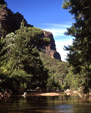
The Wollemi National Park is a protected national park and wilderness area that is located in the Central West and Hunter region of New South Wales, in eastern Australia. The 501,703-hectare (1,239,740-acre) park, the second largest national park in New South Wales, contains the 361,113-hectare (892,330-acre) Wollemi Wilderness – the largest such wilderness area in Australia – and is situated approximately 130 kilometres (81 mi) northwest of Sydney.

<span class="mw-page-title-main">Cudgegong River</span> River in New South Wales, Australia

Cudgegong River, a perennial stream that is part of the Macquarie catchment within the Murray–Darling basin, is located in the central western and Orana districts of New South Wales, Australia.

<span class="mw-page-title-main">Mudgee</span> Town in New South Wales, Australia

Mudgee is a town in the Central West of New South Wales, Australia. It is in the broad fertile Cudgegong River valley 261 km (162 mi) north-west of Sydney and is the largest town in the Mid-Western Regional Council local government area as well as being the council seat. At the 2021 Census, its population was 11,457. The district lies across the edge of the geological structure known as the Sydney Basin.

<span class="mw-page-title-main">Gulgong</span> Town in New South Wales, Australia

Gulgong is a 19th-century gold rush town in the Central Tablelands and the wider Central West regions of the Australian state of New South Wales. The town is situated within the Mid-Western Regional Council local government area. It is located about 300 km (190 mi) north west of Sydney, and about 30 km north of Mudgee along the Castlereagh Highway. At the 2016 Census, Gulgong had a population of 2,521.

<span class="mw-page-title-main">Capertee, New South Wales</span> Town in New South Wales, Australia

Capertee pronounced is a village 46 km north of Lithgow, New South Wales, Australia. It is on an elevated site above the Capertee Valley. In 2016, the township had a population of 145 people. The Castlereagh Highway links Capertee with Lithgow to the south and Mudgee to the north. The township is surrounded by National Parks and grazing land. Principal employment is in coal mining, farming and tourism-related services. The Capertee Valley forms a part of the catchment area of the Hawkesbury River, but the village lies very close to the Great Divide watershed, with the Turon River catchment nearby to its west.

<span class="mw-page-title-main">Ilford, New South Wales</span> Town in New South Wales, Australia

Ilford is a village in New South Wales, Australia, beside the Crudine River within the Mid-Western Regional Council. It is located on the Castlereagh Highway, about 220 kilometres north-west of Sydney. At the 2016 census Ilford and the surrounding rural district had a population of 187, living in 65 private dwellings. The district also included 43 unoccupied private dwellings. Ilford was named after the English township of Ilford, from where early residents of the locality originated.

<span class="mw-page-title-main">Mid-Western Regional Council</span> Local government area in New South Wales, Australia

The Mid-Western Regional Council is a local government area in the Central West region of New South Wales, Australia. The area is located adjacent to the Castlereagh Highway that passes through the middle of the area in an approximate southeast–northwest direction.

<span class="mw-page-title-main">Central West (New South Wales)</span> Region in New South Wales, Australia

The Central West is a region in central New South Wales, Australia. The region is situated west of Sydney, which stretches from Lithgow in the east and to as far west as Lake Cargelligo, on the Lachlan River. The Central West is known for its attractions such as the Jenolan Caves, near Oberon and also wineries, as well as rural farmland and natural landscapes. The region includes major towns like, Bathurst, Orange, Mudgee, Lithgow, Parkes and Cowra. It has an area of 63,262 square kilometres (24,426 sq mi). The region also includes the sub-region known as the Central Tablelands, located in the eastern part of the region. The region known as the Orana, which includes the area surrounding Dubbo is typically classed as being a part of the Central West also.

<span class="mw-page-title-main">Bylong Valley Way</span> Road in New South Wales, Australia

Bylong Valley Way is a New South Wales regional road linking Golden Highway near Sandy Hollow to Castlereagh Highway near Ilford. It is named after the Bylong Valley, through which the road passes.

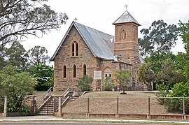
Kandos is a small town in the Central Tablelands of New South Wales, Australia, within the Mid-Western Regional Council. The area is the traditional home of the Dabee tribe of the Wiradjuri people. The town sits beneath Cumber Melon Mountain, in a district formerly known as Coomber. Kandos shares its locality, employment and infrastructure with the neighbouring town Rylstone, 6 kilometres away. At the 2021 census, Kandos had a population of 1263.

Portland is a town in the Central Tablelands of New South Wales, Australia. At the 2016 census, Portland had a population of 2,424 people. The town was named after Australia's first cement works.

<span class="mw-page-title-main">Baerami, New South Wales</span> Town in New South Wales, Australia

Baerami is a locality in the Muswellbrook Shire in the Upper Hunter region of New South Wales, Australia.

<span class="mw-page-title-main">Gwabegar railway line</span>

The Gwabegar railway line is a railway line in the Central West and North West Slopes of New South Wales, Australia, which passes through the towns of Mudgee, Gulgong, Dunedoo, Coonabarabran and terminates at Gwabegar.

Tallawang is an historical locality north of Gulgong in central western New South Wales, Australia. The place name is derived from an aboriginal word for "apple gum".

<span class="mw-page-title-main">William Wall (Australian politician)</span> Australian politician (1845–1926)

William Chandos Wall was an Australian politician. He was also a prospector, geologist, minerals surveyor, commission / mining agent, inventor and a quarry and mine operator before and after entering politics. In June 1886 he was elected to the New South Wales Legislative Assembly to succeed the former NSW premier Sir John Robertson KCMG as one of the members for Mudgee. In 1894 Wall transferred to Rylstone and in July 1895 he lost the Rylstone seat.

In 2013 Bathurst, New South Wales, Australia celebrated 200 years from its naming as a town in 1813. Over the 200 years significant milestones have occurred in the town and regions infrastructure development to support growth of the region. The development of Australia progressed with a few frontier towns built in extreme isolation like Bathurst. Sydney was founded in 1788 and 25 years later in 1813 only a few other coastal towns had been established. The desire to explore the unknown areas led the Colonial Government to sponsor expeditions to the interior of the vast country. A large mountain range running parallel to the Sydney coast blocked access to the west and rugged mountains and a river blocked access to the north. Before the exploration of the inland started they had no idea what they would find but what they did discover was fertile and well watered land ideal for grazing of animals and producing agricultural products.

<span class="mw-page-title-main">Bridge View Inn</span> Historic site in New South Wales, Australia

Bridge View Inn is a heritage-listed former hotel and bank building which now contains bed and breakfast accommodation, a museum and commercial enterprises at 28–30 Louee Street, Rylstone, Mid-Western Regional Council, New South Wales, Australia. It was built from 1860 to 1870. It is also known as Bridge Hotel, Rylstone Historical Society Building, and Bridgeview Inn. The property is owned by Rylstone and District Historical Society. It was added to the New South Wales State Heritage Register on 2 April 1999.

<span class="mw-page-title-main">Rylstone railway station, New South Wales</span> Historic site in New South Wales, Australia

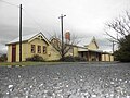
Rylstone railway station is a heritage-listed former railway station on the Gwabegar railway line at Rylstone, Mid-Western Regional Council, New South Wales, Australia. Although it closed to regular passenger services in 1985, it is planned to restore a tourist service between Kandos and Rylstone in late 2018. The property was added to the New South Wales State Heritage Register on 2 April 1999.

Clandulla is a village in New South Wales, Australia, within the Mid-Western Regional Council, about 225 kilometres north-west of Sydney. At the 2016 census Clandulla and the surrounding rural district had a population of 197, living in 61 private dwellings. The township and district also included 22 unoccupied private dwellings. Clandulla is bounded to the west and north by the Clandulla State Forest.

Lynette "Lyn" Syme (1948-2019) was an Australian political and labor activist, feminist and aboriginal land-rights advocate, recognized in her later years as a Wiradjuri elder of the Dabee people in what is current-day New South Wales.

References

  1. 1 2 Australian Bureau of Statistics (28 June 2022). "Rylstone". 2021 Census QuickStats. Retrieved 25 September 2022. OOjs UI icon edit-ltr-progressive.svg
  2. 1 2 3 4 5 6 7 8 9 10 11 12 13 14 15 16 17 18 19 20 21 22 23 William Staff (1999). A History of Rylstone. p. 260. ISBN   0-9588597-7-9.
  3. Diane Simmonds. "Early Settlement Pioneers" . Retrieved 13 March 2011.
  4. "Kandos Rylstone History Pt1". Mudgee District Local History. 2010. Retrieved 19 March 2011.
  5. "Journey to the Pass". The Allan Cunningham Project. Retrieved 24 January 2012.
  6. "Ryalston". Morning Chronicle. 11 April 1846. Retrieved 15 August 2011.
  7. "Ryalstone". Empire. Trove Australia. 25 May 1857. Retrieved 15 August 2011.
  8. "A Trip Through the Country Between Mudgee and Muswellbrook". Sydney Morning Herald . 24 December 1873.
  9. "Intercolonial News". The Brisbane Courier. 10 June 1884. Retrieved 13 March 2011.
  10. "DISTRICT NEWS". Maitland Daily Mercury . NSW: National Library of Australia. 3 April 1895. p. 2. Retrieved 12 October 2014.
  11. The end of the Gwabegar line Railway Digest May 1992 page 184
  12. Intelligence Railway Gazette International November 2000 page 702
  13. "Coal trains may be back on track". Mudgee Guardian & Gulgong Advertiser . 18 September 2009. Retrieved 13 March 2011.
  14. "Slow train coming". Mudgee Guardian. 29 January 2010. Retrieved 22 March 2011.
  15. Elliott, Honor (24 October 2017). "All-aboard the region's new $1.1M rail line". Mudgee Guardian. Retrieved 30 October 2017.
  16. "The Wollemi Pine". Website. Hawkesbury Tourism. 2006. Retrieved 16 April 2011.
  17. "The Wiradjuri Nation - Peggy & Jimmy Lambert". Mudgee District Local History. Mudgee History. 2010. Retrieved 19 March 2011.
  18. 1 2 "Rylstone & District Historical Society". Rylstone & District Historical Society. Retrieved 13 March 2011.
  19. "From the Interior". The Sydney Morning Herald. 23 May 1853. Retrieved 13 March 2011.
  20. "St James new church". The Sydney Morning Herald. 19 May 1857. Retrieved 13 March 2011.
  21. "Rylstone, Cudgegong and Ilford". The Sydney Morning Herald. 22 November 1875. Retrieved 13 March 2011.
  22. "Gold in NSW". Adelaide Advertiser . 22 August 1894. Retrieved 13 March 2011.
  23. "A Nice Nugget". The Sydney Morning Herald. 30 April 1897. Retrieved 13 March 2011.
  24. "Federal Capital League". The Sydney Morning Herald. 18 May 1904. Retrieved 14 March 2011.
  25. "The Federal Capital". The Sydney Morning Herald. 20 November 1899. Retrieved 14 March 2011.
  26. "Site of the Federal Capital". The Sydney Morning Herald. 15 May 1900. Retrieved 14 March 2011.
  27. "Discovery of Coal at Rylstone". The Sydney Morning Herald. 2 November 1903. Retrieved 13 March 2011.
  28. "Telephone to Rylstone". Mudgee Guardian & North-Western Representative . NSW: National Library of Australia. 1 February 1906. p. 13. Retrieved 12 October 2014.
  29. "Establishing Iron & Steel Industries at Rylstone". The Sydney Morning Herald. 7 December 1907. Retrieved 13 March 2011.
  30. "RYLSTONE TELEPHONE". Mudgee Guardian & North-Western Representative . NSW: National Library of Australia. 7 November 1914. p. 2. Retrieved 12 October 2014.
  31. "TELEPHONES". Mudgee Guardian & North-Western Representative . NSW: National Library of Australia. 6 August 1914. p. 26. Retrieved 29 October 2014.
  32. "Rylstone - Bylong Telephone". Mudgee Guardian and North-Western Representative (NSW : 1890–1954) . NSW: National Library of Australia. 29 April 1915. p. 30. Retrieved 12 October 2014.
  33. "Tenders Accepted". The Sydney Morning Herald. 27 April 1915. Retrieved 14 March 2011.
  34. "TELEPHONE TRUNK LINES TO MUDGEE". Mudgee Guardian & North-Western Representative . NSW: National Library of Australia. 4 February 1924. p. 8. Retrieved 1 August 2015.
  35. "Rylstone school destroyed by fire". Barrier Miner. 9 August 1925. Retrieved 13 March 2011.
  36. "New Cement Works". The Sydney Morning Herald. 31 August 1925. Retrieved 13 March 2011.
  37. 1 2 "Rylstone Shire Lighting". The Sydney Morning Herald. 12 March 1926. Retrieved 13 March 2011.
  38. "News article". The Canberra Times. 11 November 1926. Retrieved 14 March 2011.
  39. "Record Fall at Rylstone". The Sydney Morning Herald. 29 March 1926. Retrieved 13 March 2011.
  40. "Shale Oil, rich discovery at Rylstone". The Sydney Morning Herald. 11 August 1931. Retrieved 13 March 2011.
  41. "Hospital additions". The Sydney Morning Herald. 3 August 1935. Retrieved 13 March 2011.
  42. "Public works at Rylstone". The Sydney Morning Herald. 20 July 1938. Retrieved 13 March 2011.
  43. Gulgong Writing Group (1984). Travelling down the Cudgegong. Dubbo: Macquarie Press. pp. 45 of 151.
  44. "Bridge View Inn". New South Wales State Heritage Register . Department of Planning & Environment. H00438. Retrieved 18 May 2018. CC BY icon.svg Text is licensed by State of New South Wales (Department of Planning and Environment) under CC-BY 4.0 licence .
  45. "Rylstone Railway Station and yard group". New South Wales State Heritage Register . Department of Planning & Environment. H01240. Retrieved 18 May 2018. CC BY icon.svg Text is licensed by State of New South Wales (Department of Planning and Environment) under CC-BY 4.0 licence .
  46. Department of Local Government (March 2004). "Rylstone Shire Council Public Inquiry Report" . Retrieved 13 March 2011.
  47. Western NSW Local Health Network. "Rylstone District Hospital". NSW Department of Health. Retrieved 13 March 2011.
  48. "Orana-Mid Western Police District - NSW Police Public Site". www.police.nsw.gov.au. Retrieved 5 November 2018.
  49. "Rylstone Court House". Locations of Local Courts. Department of Justice and Attorney General. 30 July 2007. Retrieved 13 March 2011.
  50. "Our Area". Website. Integral Energy. 2011. Retrieved 16 March 2011.
  51. "Kandos Rylstone Radio". KRR FM. Retrieved 14 March 2011.
  52. "Real FM Website" . Retrieved 14 March 2011.
  53. "License Areas" (PDF). Australian Communications & Media Authority. March 2004. p. 9. Retrieved 14 March 2011.
  54. "Remote Central and Eastern Television License Area Map" (PDF). MySatTV. 25 October 2005. Retrieved 14 March 2011.
  55. "Things to see and do". Cudgegong Business Group. 2011. Retrieved 14 March 2011.
  56. "Ferntree Gully Reserve and Beyond". Rylstone Kandos. 25 February 2015. Retrieved 16 April 2018.
  57. https://rylstoneaerodrome.com.au/
  58. "Paragliding" . Retrieved 13 March 2011.
  59. "rylstone airfield sold but operating". Mudgee Guardian. 31 December 2010. Retrieved 13 March 2011.
  60. "Bylong Valley Way, Australia". Road Traffic Technology.com. 2011. Retrieved 16 March 2011.
  61. "Bylong Valley Way now an important state road link". Mudgee Guardian. 16 April 2009. Retrieved 16 March 2011.
  62. "Pave the Way". Mudgee Guardian. 15 December 2006. Retrieved 16 March 2011.
  63. "Mining in NSW". NSW Minerals Council. Retrieved 14 March 2011.
  64. "Rylstone Coal Resource Assessment". 29 June 2000. Retrieved 14 March 2011.
  65. "Limestone Mining". Cement Australia. Retrieved 14 March 2011.
  66. "Rylstone Project". Strategic Elements. Retrieved 14 March 2011.
  67. "Rylstone". The Sydney Morning Herald. Retrieved 13 March 2011.
  68. "Rylstone Streetfeast". ABC Radio. 5 November 2004. Retrieved 14 March 2011.
  69. "The Rylstone Classic". The Rylstone Classic. Retrieved 14 October 2019.
  70. 1 2 "Summary statistics Mudgee (George Street)". Bureau of Meteorology.
  71. Western Region timetable NSW TrainLink
  72. "Website". Aeropelican Air Services. Retrieved 14 March 2011.
  73. "Lieutenant W.V. Dowling". The Sydney Morning Herald. Retrieved 14 March 2011.
  74. "Heroes of the Dardanelles". The Sydney Morning Herald. 21 August 1915. Retrieved 14 March 2011.
  75. "Alfred Robbins". 8 October 1915. Retrieved 14 March 2011.
  76. "Anzac Officers died at Gallipoli". anzacs.org. Retrieved 19 March 2011.
  77. Jack Pennell and Lola Phillips (2000). "Kandos Rylstone History WW1". Mudgee Local History Group. Retrieved 19 March 2011.