
Grand Canyon National Park, located in northwestern Arizona, is the 15th site in the United States to have been named a national park. The park's central feature is the Grand Canyon, a gorge of the Colorado River, which is often considered one of the Wonders of the World. The park, which covers 1,217,262 acres of unincorporated area in Coconino and Mohave counties, received more than six million recreational visitors in 2017, which is the second highest count of all American national parks after Great Smoky Mountains National Park. The Grand Canyon was designated a World Heritage Site by UNESCO in 1979.

The Morton National Park is a 199,745-hectare (493,580-acre) national park located in the Southern Highlands, South Coast and Illawarra regions of New South Wales, Australia, situated approximately 170 kilometres (110 mi) south southwest of Sydney.
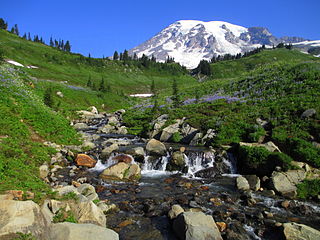
Mount Rainier National Park is an American national park located in southeast Pierce County and northeast Lewis County in Washington state. The park was established on March 2, 1899 as the fifth national park in the United States, preserving 236,381 acres including all of Mount Rainier, a 14,411-foot (4,392 m) stratovolcano. The mountain rises abruptly from the surrounding land with elevations in the park ranging from 1,600 feet to over 14,000 feet. The highest point in the Cascade Range, Mount Rainier is surrounded by valleys, waterfalls, subalpine meadows, and 91,000 acres of old-growth forest. More than 25 glaciers descend the flanks of the volcano, which is often shrouded in clouds that dump enormous amounts of rain and snow.
Yoho National Park is located in Canada's Rocky Mountains along the western slope of the Continental Divide of the Americas in southeastern British Columbia. Yoho NP is bordered by Kootenay National Park on the southern side and Banff National Park on the eastern side in Alberta. The name Yoho comes from the Cree word for awe and wonder.

Banff National Park is Canada's oldest national park and was established in 1885. Located in the Rocky Mountains, 110–180 kilometres (68–112 mi) west of Calgary in the province of Alberta, Banff encompasses 6,641 square kilometres (2,564 sq mi) of mountainous terrain, with numerous glaciers and ice fields, dense coniferous forest, and alpine landscapes. The Icefields Parkway extends from Lake Louise, connecting to Jasper National Park in the north. Provincial forests and Yoho National Park are neighbours to the west, while Kootenay National Park is located to the south and Kananaskis Country to the southeast. The main commercial centre of the park is the town of Banff, in the Bow River valley.

Badlands are a type of dry terrain where softer sedimentary rocks and clay-rich soils have been extensively eroded by wind and water. They are characterized by steep slopes, minimal vegetation, lack of a substantial regolith, and high drainage density. They can resemble malpaís, a terrain of volcanic rock. Canyons, ravines, gullies, buttes, mesas, hoodoos and other such geologic forms are common in badlands. They are often difficult to navigate by foot. Badlands often have a spectacular color display that alternates from dark black/blue coal stria to bright clays to red scoria.

Mount Robson Provincial Park is a vast provincial park in the Canadian Rockies with an area of 2,249 km². The park is located entirely within British Columbia, bordering Jasper National Park in Alberta. The B.C. legislature created the park in 1913, the same year as the first ascent of Mount Robson by a party led by Conrad Kain. It is the second oldest park in the provincial system. The park is named for Mount Robson, which has the highest point in the Canadian Rockies and is located entirely within the park.

Colonial National Historical Park is located in the Hampton Roads region of Virginia and is operated by the National Park Service of the United States government. The park protects and interprets several sites relating to the Colony of Virginia and the history of the United States more broadly, ranging from the site of the first landing of the English settlers who would settle at Jamestown, to the battlefields of Yorktown where the British Army was finally defeated in the American Revolutionary War. Over 3 million people visit the park each year.

Hawaiʻi Volcanoes National Park, established on August 1, 1916, is an American national park located in the U.S. state of Hawaii on the island of Hawaii. The park encompasses two active volcanoes: Kīlauea, one of the world's most active volcanoes, and Mauna Loa, the world's most massive shield volcano. The park provides scientists with insight into the birth and development of the Hawaiian Islands, and ongoing studies into the processes of volcanism. For visitors, the park offers dramatic volcanic landscapes, as well as glimpses of rare flora and fauna.

The Redwood National and State Parks (RNSP) are a complex of several state and national parks located in the United States, along the coast of northern California. Comprising Redwood National Park and California's Del Norte Coast, Jedediah Smith, and Prairie Creek Redwoods State Parks, the combined RNSP contain 139,000 acres (560 km2), and feature old-growth temperate rainforests. Located entirely within Del Norte and Humboldt Counties, the four parks, together, protect 45% of all remaining coast redwood old-growth forests, totaling at least 38,982 acres (157.75 km2). These trees are the tallest and one of the most massive tree species on Earth. In addition to the redwood forests, the parks preserve other indigenous flora, fauna, grassland prairie, cultural resources, portions of rivers and other streams, and 37 miles (60 km) of pristine coastline.

Northwest is the northwestern quadrant of Washington, D.C., the capital of the United States, and is located north of the National Mall and west of North Capitol Street. It is the largest of the four quadrants of the city, and it includes the central business district, the Federal Triangle, and the museums along the northern side of the National Mall, as well as many of the District's historic neighborhoods.
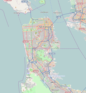
The San Francisco Maritime National Historical Park is located in San Francisco, California, United States. The park includes a fleet of historic vessels, a visitor center, a maritime museum, and a library/research facility. The park used to be referred to as the San Francisco Maritime Museum, however the former 1951 name changed in 1978 when the collections were acquired by the National Park Service. Today's San Francisco Maritime National Historical Park was authorized in 1988; the maritime museum is among the park's many cultural resources. The park also incorporates the Aquatic Park Historic District, bounded by Van Ness Avenue, Polk Street, and Hyde Street.

Hopewell Culture National Historical Park is a United States national historical park with earthworks and burial mounds from the Hopewell culture, indigenous peoples who flourished from about 200 BC to AD 500. The park is composed of six separate sites in Ross County, Ohio, including the former Mound City Group National Monument. The park includes archaeological resources of the Hopewell culture. It is administered by the United States Department of the Interior's National Park Service.

This is a list of the buildings, sites, districts, and objects listed on the National Register of Historic Places in the Republic of Palau. There are currently 6 listed sites located in only four of the sixteen states of Palau.

Muncho Lake Provincial Park is a provincial park in British Columbia, Canada, located on the Alaska Highway as it transits the northernmost Canadian Rockies west of Fort Nelson. The park is part of the larger Muskwa-Kechika Management Area. It is named after Muncho Lake, which is in the park and is both the name of the lake and of the community located there.
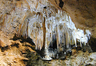
Carlsbad Caverns National Park is an American national park in the Guadalupe Mountains of southeastern New Mexico. The primary attraction of the park is the show cave, Carlsbad Cavern. Visitors to the cave can hike in on their own via the natural entrance or take an elevator from the visitor center.
Boston, Massachusetts is home to a large number of listings on the National Register of Historic Places. This list encompasses those locations that are located north of the Massachusetts Turnpike. See National Register of Historic Places listings in southern Boston for listings south of the Turnpike. Properties and districts located elsewhere in Suffolk County's other three municipalities are also listed separately.
Boston, Massachusetts is home to a large number of listings on the National Register of Historic Places. This list encompasses those locations that are located south of the Massachusetts Turnpike. See National Register of Historic Places listings in northern Boston for listings north of the Turnpike. Properties and districts located elsewhere in Suffolk County's other three municipalities are also listed separately.

Cesar E. Chavez National Monument is a 116-acre (47 ha) U.S. National Monument in Keene, Kern County, California located about 32 miles away from Bakersfield, California. The property was the headquarters of the United Farm Workers (UFW), and home to César Chávez from the early 1970s until his death in 1993, Chávez's gravesite is located in the property's gardens along with that of his wife, Helen Fabela Chávez. Originally developed as a headquarters and worker housing area for a quarry, it served as a tuberculosis sanitarium in the early 1900s, until its acquisition by the UFW in the early 1970s.


