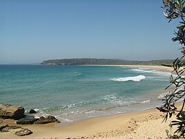
Beowa National Park, formerly Ben Boyd National Park, is a national park in New South Wales, Australia, 578 km (359 mi) south of Sydney. It was established in 1971 and officially renamed in 2022 owing to its previous namesake's connection with blackbirding. Beowa means "orca", an animal of significance to the traditional owners, the Thaua people.

Biamanga National Park is a protected area in New South Wales, Australia, 408 km (254 mi) south of Sydney and 40 km (25 mi) north of Bega. The park forms part of the Ulladulla to Merimbula Important Bird Area because of its importance for swift parrots.

The Bournda National Park is a 2,655-hectare (6,560-acre) protected area in New South Wales, Australia, managed as a national park by NSW National Parks and Wildlife Service, and was established on 24 April 1992. It forms part of the Ulladulla to Merimbula Important Bird Area, identified as such by BirdLife International because of its importance for swift parrots.
Clyde River is a national park in south-eastern New South Wales (Australia) between Batemans Bay and Nelligen. It includes 9 km of river frontage to the Clyde River, bounded on three sides by the Clyde River and on the northeast by the Kings Highway. It was created from a part of Benandarah State Forest; in 2000 10.91 km2 of the state forest was set aside as a national park. The park forms part of the Ulladulla to Merimbula Important Bird Area, identified as such by BirdLife International because of its importance for swift parrots.

Eurobodalla National Park is a non-contiguous national park in New South Wales, Australia, 268 km southwest of Sydney spanning from Moruya Heads to Tilba Tilba Lake, 12 km south of Narooma. The park forms part of the Ulladulla to Merimbula Important Bird Area, identified as such by BirdLife International because of its importance for swift parrots.

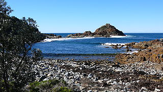
Gulaga National Park is a national park on the south coast of New South Wales, Australia, about 15 kilometres (9.3 mi) south of Narooma. The park is dominated by Gulaga, also known as Mount Gulaga. The former Wallaga Lake National Park, Goura Nature Reserve, and Mount Dromedary Flora Reserve were combined to form this park in 2001. The park features the southernmost subtropical rainforest in New South Wales.

Hat Head is a national park on the Mid North Coast of New South Wales, Australia, 461.7 kilometres (286.9 mi) north-east of Sydney. It lies within the Hastings-Macleay Important Bird Area. Within the park is the eponymous village of Hat Head, with about 320 inhabitants.
Mimosa Rocks is a national park in New South Wales, Australia, 329 km southwest of Sydney near the towns of Tathra and Bermagui. The park is close to Bournda National Park and forms part of the Ulladulla to Merimbula Important Bird Area, identified as such by BirdLife International because of its importance for swift parrots.

Murramarang is a national park in New South Wales, Australia, 206 km (128 mi) southwest of Sydney. It follows the coastline from Long Beach north to Merry Beach near Ulladulla. It is surrounded by three state forests, Kioloa, South Brooman, and Benandarrah. The park forms part of the Ulladulla to Merimbula Important Bird Area, identified as such by BirdLife International because of its importance for swift parrots.

The South East Forests National Park is a national park located in between the Monaro and South Coast regions of New South Wales, Australia. The 115,177-hectare (284,610-acre) national park is situated 378 kilometres (235 mi) southwest of Sydney. It features high quality old growth eucalyptus forest and remnant patches of temperate rainforest.

Wolli Creek is an urban watercourse of the Cooks River catchment located in the southern suburbs of Sydney, in New South Wales, Australia.

Merimbula is a town on the Merimbula Lake, located on the Far South Coast or Sapphire Coast of New South Wales, Australia. At the 2016 census, the population was 3,544.
The Manly Dam Reserve, also known as the Manly Warringah War Memorial Park, is an urban bushland reserve located in the Northern Beaches region of Sydney, Australia. The reserve adjoins the south-eastern edge of Garigal National Park.

Mystery Bay is a small town on the south coast of New South Wales, Australia. Mystery Bay is halfway between Central Tilba and Narooma, two kilometres off the Princes Highway on Mystery Bay Road. At the 2016 census, Mystery Bay had a population of 191. Mystery Bay features a camping area in the Eurobodalla National Park. This park is known for its recreational activities and various species of Bird. Montague Island is close to Mystery Bay and is known for its unusual quantities of Penguin called Eudyptula minor and fur seals. There is also an Infestation of a specific type of House mouse called Mus musculus which has needed eradication because of its damage on the ecosystem.

Arctostaphylos confertiflora is a rare species of manzanita known by the common name Santa Rosa Island manzanita. This shrub is endemic to California, where it grows on the sandstone bluffs of Santa Rosa Island in the Channel Islands. This manzanita is listed as an endangered species by the United States Government.

Tabourie Lake, formerly Toubouree Lake is a small village in the suburb of Lake Tabourie, in the South Coast region of New South Wales, Australia and is within the City of Shoalhaven local government area. The village takes its name from the lagoon formed at the entry of Tabourie Creek into the ocean. Crampton Island lies immediately off shore with access available by foot at low tide. Lake Tabourie is located within Meroo National Park and the bush surrounding the lake is made up of ecologically unique Bangalay Sand Forest. A caravan and camping park is located between the beach and the lake. The village boasts a small museum, opened in 1965 with a collection of local historical exhibits, including fauna, Aboriginal artifacts, and historical furnishings and machinery. The museum and collection was given to the Shoalhaven City Council by its founder Jack Nicholson in 1983.

The Ulladulla to Merimbula Important Bird Area comprises a strip of coastal and subcoastal land stretching along the southern coastline of New South Wales, Australia. It is an important site for swift parrots.

The Wolli Creek Regional Park is a 50 hectares regional park, located adjacent to Wolli Creek within the Wolli Creek Valley, between Bexley North and Tempe in south-west Sydney, New South Wales, Australia.

Wallumatta Nature Reserve, also called the Macquarie Hospital Bushland, is a 6-hectare (15-acre) nature reserve bushland area, surrounded by the residential suburb of East Ryde, in suburban Sydney, Australia. Once part of the Field of Mars of 1804, the reserve is the largest surviving area of Sydney Turpentine-Ironbark Forest, an endangered ecosystem. Soils are based on Ashfield Shale and Hawkesbury Sandstone.

Limeburners Creek National Park is a protected national park on the Mid North Coast of New South Wales, Australia. The 91.2 km national park is located 5 km (3.1 mi) to the north of Port Macquarie and exists across both the Kempsey Shire and Port Macquarie-Hastings Council local government areas, but is chiefly managed by National Parks and Wildlife Service. The area was originally erected as a nature reserve but this reservation was revoked when it became formally recognised as a national park in 2010 under the National Parks and Wildlife Act (1974). Many threatened ecological habitats and species of fauna and flora are found within this park, alongside several heritage sites of cultural significance, particularly to the local Birpai and Dunghutti people upon whose land the park exists. The protected status of this national park is largely owing to the ecological and cultural value of the area, in addition to the value of the ecosystems to further scientific research.