Brisbane Water National Park is a national park on the Central Coast of New South Wales, Australia. The national park is situated 70 kilometres (43 mi) north of Sydney and 12 kilometres (7.5 mi) southwest of Gosford. It consists the Brisbane Water and Mooney Mooney Creek waterways.

The Gardens of Stone National Park is a protected national park that is located in the Central Tablelands region of New South Wales in eastern Australia. The 15,080-hectare (37,300-acre) national park is situated 125 kilometres (78 mi) northwest of Sydney, and 30 kilometres (19 mi) northwest of Lithgow. The national park draws its name from the natural stone pagodas within its boundaries.

The Chiltern-Mt Pilot National Park is a national park that is located in the Hume region of Victoria, Australia. The 21,650-hectare (53,500-acre) national park is situated approximately 275 kilometres (171 mi) northeast of Melbourne, and extends west from Beechworth across the Hume Freeway and the Albury-Melbourne railway line to the west of Chiltern.
This is an index of conservation topics. It is an alphabetical index of articles relating to conservation biology and conservation of the natural environment.
Taunton National Park is situated near the town of Dingo approximately 135 km inland from Rockhampton in eastern Central Queensland, Australia. The park encompasses an area of 11,626 ha within the Northern Brigalow Belt bioregion of Queensland; a region widely recognised to contain considerable biodiversity.

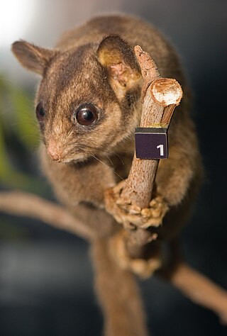
Leadbeater's possum is a critically endangered possum largely restricted to small pockets of alpine ash, mountain ash, and snow gum forests in the Central Highlands of Victoria, Australia, north-east of Melbourne. It is primitive, relict, and non-gliding, and, as the only species in the petaurid genus Gymnobelideus, represents an ancestral form. Formerly, Leadbeater's possums were moderately common within the very small areas they inhabited; their requirement for year-round food supplies and tree-holes to take refuge in during the day restricts them to mixed-age wet sclerophyll forest with a dense mid-story of Acacia. The species was named in 1867 after John Leadbeater, the then taxidermist at the Museum Victoria. They also go by the common name of fairy possum. On 2 March 1971, the State of Victoria made the Leadbeater's possum its faunal emblem.
The conservation status of a group of organisms indicates whether the group still exists and how likely the group is to become extinct in the near future. Many factors are taken into account when assessing conservation status: not simply the number of individuals remaining, but the overall increase or decrease in the population over time, breeding success rates, and known threats. Various systems of conservation status are in use at international, multi-country, national and local levels, as well as for consumer use such as sustainable seafood advisory lists and certification. The two international systems are by the International Union for Conservation of Nature (IUCN) and The Convention on International Trade in Endangered Species of Wild Fauna and Flora (CITES).

The Golden Gate Biosphere Network is a voluntary coalition of federal, state and local government agencies, nonprofit organizations, universities, and private partners within the Golden Gate Biosphere region. The Network aims to protect the region's biodiversity and conserve its natural resources. The Network has been part of the UNESCO Man and Biosphere Programme since 1988 and is part of the US Biosphere Network as well as EuroMAB. It is recognized by UNESCO for its "significance for biological diversity conversation" and organizational efforts involving municipal authorities and private interests.

The Santa Rosa and San Jacinto Mountains National Monument is a National Monument in southern California. It includes portions of the Santa Rosa and San Jacinto mountain ranges, the northernmost ones of the Peninsular Ranges system. The national monument covers portions of Riverside County, west of the Coachella Valley, approximately 100 miles (160 km) southeast of downtown Los Angeles.

The Meghalaya subtropical forests is an ecoregion of Northeast India. The ecoregion covers an area of 41,700 square kilometers (16,100 sq mi), and despite its name, comprise not only the state of Meghalaya, but also parts of southern Assam, and a tiny bit of Nagaland around Dimapur and adjacent Bangladesh. It also contains many other habitats than subtropical forests, but the montane subtropical forests found in Meghalaya is an important biome, and was once much more widespread in the region, and for these reasons chosen as the most suitable name. The scientific designation is IM0126.

Mulligans Flat Woodland Sanctuary is a protected area situated in the Gungahlin district in north Canberra in the Australian Capital Territory. It has several trails for walking, running and cycling. The sanctuary functions as a fieldwork site for researchers studying native ecology.

Established in 1965, the Yellingbo Nature Conservation Reserve is located 45 km east of Melbourne in the Upper Yarra Valley, near the towns of Yellingbo, Launching Place, Yarra Junction, Hoddles Creek, Cockatoo, Emerald, Monbulk and Seville. Yellingbo Nature Conservation Reserve is a narrow riparian reserve with stream-frontage land along the Woori Yallock, Shepherd, Cockatoo, Macclesfield and Sheep Station Creeks.
Livingstone is a national park and state conservation area located 30 kilometres (19 mi) south of Wagga Wagga and 10 kilometres (6.2 mi) east of Mangoplah, in the South West Slopes region of south western New South Wales.

The Yanga National Park is a newly formed national park, located near the township of Balranald in south- western New South Wales. It covers an area of 66,734 hectares which includes 1,932 hectares of Yanga Nature Reserve, and has a frontage of 170 kilometres (110 mi) on the Murrumbidgee River. It is largely located in the Lower Murrumbidgee Floodplain, which is included on A Directory of Important Wetlands in Australia because of its importance as a breeding site for waterbirds when flooded.

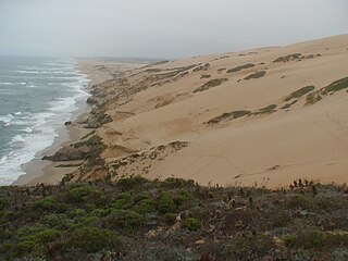
The Guadalupe-Nipomo Dunes National Wildlife Refuge is a 2,553-acre (10.33 km2) protected area located along the Central Coast of California, in southern San Luis Obispo and northern Santa Barbara Counties.
The Warby-Ovens National Park is a national park located on the lands of the Bangerang clan of the Yorta Yorta Nation in the Hume region of Victoria, Australia near Killawara. The 14,655-hectare (36,210-acre) national park is situated approximately 10 kilometres (6.2 mi) west of Wangaratta and 240 kilometres (150 mi) northeast of Melbourne.

The Dharawal National Park is a protected national park that is located in the Illawarra region of New South Wales, in eastern Australia. The 6,508-hectare (16,080-acre) national park is situated between the Illawarra Range and the Georges River and is approximately 45 kilometres (28 mi) south west of Sydney. There are three entry points to the park: from the east through Darkes Forest; from the north through Wedderburn; and from the south through Appin.
The Queanbeyan Nature Reserve is a protected nature reserve that is located in the Southern Tablelands region of New South Wales, in eastern Australia. The 67-hectare (170-acre) reserve is situated approximately 4 kilometres (2.5 mi) west-south-west of the City of Queanbeyan.
Carpenter Rocks Conservation Park is a protected area located in the Australian state of South Australia in the locality of Carpenter Rocks about 370 kilometres (230 mi) south-east of the state capital of Adelaide and about 1.5 kilometres (0.93 mi) south east of the town centre in Carpenter Rocks.

Mugii Murum-ban State Conservation Area is north of Lithgow, north-east of Capertee and south-east of Mudgee.


