The Australian Capital Territory (ACT), known as the Federal Capital Territory (FCT) until 1938, is a federal territory of Australia. Canberra, the capital city of Australia, is located in this territory. It is located in southeastern Australian mainland as an enclave completely within the state of New South Wales. Founded after Federation as the seat of government for the new nation, the territory hosts the headquarters of all important institutions of the Australian Government.

The Jervis Bay Territory is an internal territory of Australia. It was established in 1915 from part of New South Wales (NSW), in order to give the landlocked Australian Capital Territory (ACT) access to the sea.
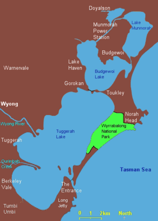
The Wyrrabalong National Park is a coastal national park that is located on the Central Coast of New South Wales, in eastern Australia. The 620-hectare (1,500-acre) national park consists of two sections; the northern section consists of approximately 480 hectares and covers a substantial area of the peninsula between The Entrance and Norah Head as well as Terilbah and Pelican Islands within Tuggerah Lake. The southern section consists of about 120 hectares of the coast, from Shelly Beach south to Forresters Beach. The park is also noted for containing the last significant coastal (littoral) rainforest on the Central Coast.

The City of Shoalhaven is a local government area in the South Coast region of New South Wales, Australia. The area is about 200 kilometres (120 mi) south of Sydney. The Princes Highway passes through the area, and the South Coast railway line traverses the northern section, terminating at Bomaderry. At the 2021 census, the population was 108,531.

Jervis Bay is a 102-square-kilometre (39 sq mi) Oceanic bay and village in the Jervis Bay Territory (ACT) and on the South Coast of New South Wales, Australia.

The Clyde River is an open intermediate tide-dominated drowned valley estuary or perennial river that flows into the Tasman Sea at Batemans Bay, located in the South Coast region of New South Wales, Australia.

Huskisson is a village in New South Wales, Australia in the City of Shoalhaven, on the shores of Jervis Bay. It is 24 km south-east of Nowra.
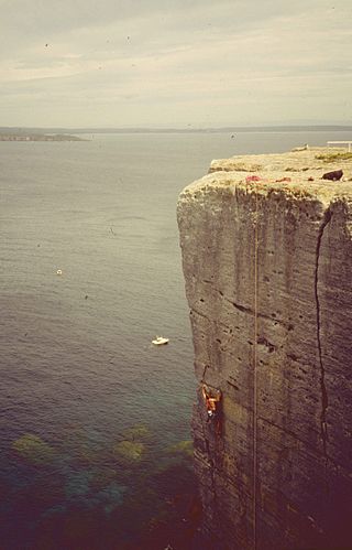
Beecroft Peninsula is the northern headland of Jervis Bay, on Australia's east coast. On the western and southern sides of the peninsula steep sandstone cliffs rise out of the ocean, up to 91 metres at its southernmost point, Point Perpendicular. White sandy beaches are found along the northern, eastern and southern sides interspersed with numerous intertidal reefs.

Broulee is a town on the south coast of New South Wales between Batemans Bay and Moruya. At the 2016 census, the town had a population of 1,717. Just off the beach is Broulee Island, currently joined to the mainland, but in past years the connecting spit has been covered by water, at times a very deep navigable channel with a strong current.

Vincentia is a town in New South Wales, Australia in the City of Shoalhaven, on the shores of Jervis Bay. It is roughly 25 kilometres (16 mi) southeast of Nowra, and approximately 200 kilometres (120 mi) south of Sydney. At the 2016 census, the population of Vincentia was 3,290. It is also a tourist spot with a beach area featuring white sand and a number of motels.
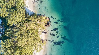
Hyams Beach is a seaside village in the City of Shoalhaven, New South Wales, Australia, on the shores of Jervis Bay. At the 2016 census, it had a population of 112. The village, 180 km south of Sydney, is bordered by two beaches, Chinaman's Beach to the north and Seaman's Beach to the south, with Hyams Beach being in the centre. A seaside resort, its beach is known for having turquoise/aqua-coloured waters and fine, squeaky, brilliantly white sand composed of pure quartz.
The South Coast refers to the narrow coastal belt from the Shoalhaven district in the north to the state border with Victoria in the south in the south-eastern part of the State of New South Wales, Australia. It is bordered to the west by the coastal escarpment of the Southern Tablelands, and is largely covered by a series of national parks, namely Jervis Bay National Park, Eurobodalla National Park, and Beowa National Park. To the east is the coastline of the Pacific Ocean, which is characterised by rolling farmlands, small towns and villages along a rocky coastline, interspersed by numerous beaches and lakes.
Wreck Bay Village, formerly Wreck Bay Aboriginal Reserve, is an Aboriginal village in the Jervis Bay Territory, Australia. At the 2016 census the population was 152. It is mainly an Australian Aboriginal community, run by the Wreck Bay Aboriginal Community Council.
Wrights Beach is a town in the City of Shoalhaven in New South Wales, Australia. It is on the shores of St Georges Basin, near the Jervis Bay Territory.

The Parish of Bherwerre is a parish of the County of St Vincent in New South Wales which formerly included the area that is now the Jervis Bay Territory, which was transferred to the Commonwealth of Australia in 1915. Because of this, the parish is now less than half the size it was in the nineteenth century. The Jervis Bay Territory Acceptance Act of 1915 mentions that 18,000 acres (7,300 ha) of the parish were transferred to the Commonwealth. The Seat of Government Acceptance Act of 1909 mentions that three separate parcels in the parish were planned to be transferred to the Commonwealth from Bherwerre, along with land in other nearby parishes, although the actual land transfer in 1915 was only made up of land in the Parish of Bherwerre. The land mentioned in the 1909 act was a 2-square-mile (5.2 km2) portion, a 412-acre (167 ha) portion, and the 132 acres (53 ha) of Bowen Island. At the time, the parish was located in Clyde Shire.
Environa is a suburb and locality of Queanbeyan, located in the Queanbeyan–Palerang Regional Council, in New South Wales, Australia, west of Jerrabomberra Creek and nearby the New South Wales and Australian Capital Territory border. The suburb was historically designated as a planned community that subsequently did not come to fruition, however, Environa has since been allocated as part of the South Jerrabomerra development of Queanbeyan for proposed development, including the proposed developments of Tralee and Poplars.

Henry Ferdinand Halloran was a major property owner and developer in New South Wales in the early part of the twentieth century.
Tomerong is a village in the South Coast region of New South Wales, Australia. It is located approximately 180 kilometres by road south from the state capital Sydney and 20 kilometres south of the commercial centre of the City of Shoalhaven, Nowra in the County of St Vincent. The village is eight kilometres inland of the western shores of Jervis Bay. Its population at the 2021 census was 1,194.

Callala Beach is a small town on the South Coast of New South Wales, Australia in the City of Shoalhaven. Like most beaches in Jervis Bay, it is known to have brilliantly white sand and aqua blue waters. The beach is a tourist spot and is a 2.5-hour drive from Sydney, located to its south.

Bherwerre Beach is a long beach located in Booderee National Park, Jervis Bay Territory, Australia. It is approximately 7 kilometres (4.3 mi) long and is bordered by Cave Beach to the east and Sussex Inlet to the west.