
The Garigal National Park is a protected national park that is located within the North Shore and Forest District regions of Sydney, New South Wales, in eastern Australia. The 2,202-hectare (5,440-acre) national park is situated approximately 20 kilometres (12 mi) north of the Sydney central business district.

Ku-ring-gai Chase National Park is a national park on the northern side of Sydney in New South Wales, Australia. The 14,977-hectare (37,010-acre) park is 25 kilometres (16 mi) north of the Sydney central business district and generally comprises the land east of the M1 Pacific Motorway, south of the Hawkesbury River, west of Pittwater and north of Mona Vale Road. It includes Barrenjoey Headland on the eastern side of Pittwater.

Tomaree is a national park located in New South Wales, Australia, 145–155 km (90–96 mi) northeast of Sydney in the Port Stephens local government area. It is located on the shores of the Tasman Sea, extending north from Fishermans Bay to Shoal Bay passing through Boat Harbour, One Mile, Nelson Bay and Fingal Bay.

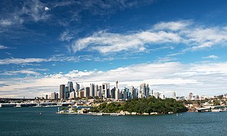
Port Jackson, consisting of the waters of Sydney Harbour, Middle Harbour, North Harbour and the Lane Cove and Parramatta Rivers, is the ria or natural harbour of Sydney, New South Wales, Australia. The harbour is an inlet of the Tasman Sea. It is the location of the Sydney Opera House and Sydney Harbour Bridge. The location of the first European settlement and colony on the Australian mainland, Port Jackson has continued to play a key role in the history and development of Sydney.

Cronulla is a suburb of Sydney, in the state of New South Wales, Australia. Boasting numerous surf beaches and swimming spots, the suburb attracts both tourists and Greater Sydney residents. Cronulla is located 26 kilometres south of the Sydney central business district, in the local government area of the Sutherland Shire.
Goat Island is a heritage-listed island located in Port Jackson, in Sydney, New South Wales, Australia. Located northwest of the Sydney central business district, Goat Island is about 300m wide in a north/south direction and 180m long in an east/west direction; and covers an area of 5.4 hectares. Goat Island lies off the shores of the Sydney suburbs of Balmain and Millers Point, at the junction of Darling Harbour with the main channel of Sydney Harbour.
Vaucluse is an eastern suburb of Sydney, in the state of New South Wales, Australia. It is located 8 kilometres (5 mi) east of the Sydney central business district, in the local government areas of Waverley Council and the Municipality of Woollahra.

Pittwater is a semi-mature tide dominated drowned valley estuary, located about 40 kilometres (25 mi) north of the Sydney central business district, New South Wales, Australia; being one of the bodies of water that separate greater Metropolitan Sydney from the Central Coast.

Little Bay is a suburb in the Eastern Suburbs of Sydney, in the state of New South Wales, Australia. Little Bay is located 14 kilometres south-east of the Sydney central business district and is part of the local government area of the City of Randwick.

Shark Island is an island located within Sydney Harbour, in New South Wales, Australia. The island is 1.5 hectares in area, measuring some 250 metres by 100 metres, and lies off the Sydney suburbs of Point Piper, Rose Bay and Vaucluse, in the eastern section of the harbour between the Harbour Bridge and the harbour entrance. The island was known by the local Aboriginal people as Boambilly, and the current name comes from its shape, which is claimed to resemble a shark. Shark Island Light is an active pile lighthouse located just north of Shark Island, an island in Sydney Harbour, New South Wales, Australia. Its light is only visible on in the fairway of the harbour, between Shark Point and Point Piper.

The Sydney Heads are a series of headlands that form the 2 km (1.2 mi) wide entrance to Sydney Harbour in Sydney, New South Wales, Australia. North Head and Quarantine Head are to the north; South Head and Dunbar Head are to the south; and Middle Head, Georges Head, and Chowder Head are to the west and within the harbour. The Heads are contained within the Sydney Harbour National Park.

The New South Wales Office of Environment and Heritage (OEH), a former division of the Government of New South Wales between April 2011 and July 2019, was responsible for the care and protection of the environment and heritage, which includes the natural environment, Aboriginal country, culture and heritage, and built heritage in New South Wales, Australia. The OEH supported the community, business and government in protecting, strengthening and making the most of a healthy environment and economy within the state. The OEH was part of the Department of Planning and Environment cluster and managed national parks and reserves.

The North Head Quarantine Station is a heritage-listed former quarantine station and associated buildings that is now a tourist attraction at North Head Scenic Drive, on the north side of Sydney Harbour at North Head, near Manly, in the Northern Beaches Council local government area of New South Wales, Australia. It is also known as North Head Quarantine Station & Reserve and Quarantine Station & Reserve. The property is owned by the Office of Environment and Heritage, an agency of the Government of New South Wales. The buildings and site were added to the New South Wales State Heritage Register on 2 April 1999. The entire 277-hectare (680-acre) North Head site, including the Quarantine Station and associated buildings and facilities, was added to the Australian National Heritage List on 12 May 2006, and now forms part of the Sydney Harbour National Park.

Bradleys Head is a headland protruding from the north shore of Sydney Harbour, within the metropolitan area of Sydney, New South Wales, Australia. It is named after the First Fleet naval officer William Bradley. The original Aboriginal inhabitants, who belonged to the Borogegal clan of the Eora nation, knew Bradleys Head as Borogegy, Booraghee, Booragy or Burrogy. On the headland is an active lighthouse, Bradleys Head Light, constructed in 1905.

Bantry Bay is a bay located in the Garigal National Park in Middle Harbour within Sydney Harbour, in New South Wales, Australia. The local Bluff Track starts at the end of Grattan Crescent Frenchs Forest. There is a steep walk down to a wharf on the bay. It was named after Bantry Bay in Ireland.

Clark Island is a small island in Sydney Harbour, near the coast of New South Wales, Australia. The island is part of the Sydney Harbour National Park and lies offshore the Sydney suburb of Darling Point, in the eastern part of Sydney Harbour between the Harbour Bridge and the harbour entrance.
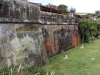
The Georges Head Battery, also called the Georges Head Military Fortifications, is a heritage-listed former military fortification located on the Georges Head on Chowder Bay Road, Georges Heights, New South Wales, Australia.

Nielsen Park is a heritage-listed historic site, park and nature reserve located at Greycliffe Avenue, Vaucluse in the Municipality of Woollahra local government area of New South Wales, Australia. The traditional lands of the Birrabirragal indigenous people, the park was designed by John Frederick Hilly, James Barnet and the Office of the New South Wales Government Architect. It is also known as Vaucluse Estate, Greycliffe Estate and Greycliffe House. It was added to the New South Wales State Heritage Register on 28 August 2017.

The Northern Beaches Council is a local government area located in the Northern Beaches region of Sydney, in the state of New South Wales, Australia. The council was formed on 12 May 2016 after the amalgamation of Manly, Pittwater, and Warringah councils.
Tambourine Bay is a bay located in between the suburbs of Riverview and Longueville in the Lower North Shore of Sydney, NSW, Australia. The bay and its adjoining creek is a northern tributary of the Lane Cove River, a ria that joins Sydney harbour to Greenwich and Woolwich. The bay's foreshore and surrounding park areas are managed by the municipality of Lane Cove.


