Broulee, New South Wales

Last updated

Broulee
New South Wales
BrouleeIsland.jpg
Broulee Island looking south from Burri Point
Australia New South Wales location map blank.svg
Red pog.svg
Broulee
Coordinates 35°51′26″S150°10′44″E / 35.8572°S 150.1789°E / -35.8572; 150.1789
Population1,947 (SAL 2021) [1]
Postcode(s) 2537
LGA(s) Eurobodalla Shire
County Dampier
Parish Broulee
State electorate(s) Bega
Federal division(s) Gilmore
Localities around Broulee:
Jeremadra Jeremadra Mossy Point
Bimbimbie Broulee Tasman Sea
Moruya Moruya Tasman Sea
Broulee in 1843; painted by John Skinner Prout in watercolour and gouache BrouleeProut1843.jpg
Broulee in 1843; painted by John Skinner Prout in watercolour and gouache
Broulee aerial photo from east Broulee Aerial.jpg
Broulee aerial photo from east

Broulee is a town on the south coast of New South Wales between Batemans Bay and Moruya. [2] [3] At the 2016 census, the town had a population of 1,717. [4] Just off the beach is Broulee Island, currently joined to the mainland, but in past years the connecting spit has been covered by water, at times a very deep navigable channel with a strong current.

Contents

The first harbour in the area south of Batemans Bay was established at Broulee behind what is now known as the island. Although settlement had already commenced on the shores of the nearby Moruya River, it was not easily navigable due to a sandbar at its mouth.

History

The Broulee area was surveyed and gazetted in 1837, a town plan made by James Larmer in 1839, [5] and land sales commenced in 1840. At that time a post office was opened with mail being delivered each week over the mountains from Braidwood. Henry Clarke took up farming in the Broulee area in the 1840s after emigrating from Ireland. The first court in the district was established also in 1840 and in 1841 Broulee was made the centre of a police district which covered the area from Jervis Bay to Eden, New South Wales.

In 1841 a flood washed away the sandbar at the mouth of the Moruya River. Land up the river was for sale from 1848 and the Moruya town site surveyed in 1850 and the town gazetted in 1851. That year gold was discovered at Araluen inland from Moruya and near Braidwood. The road from Moruya to Araluen became the preferred route and the functions that had been at Broulee shifted to the growing town of Moruya.

In 1859 the court, including the building, was relocated to Moruya. The building of the Erin-go-Bragh Hotel was also shifted from Broulee Island to Campbell St, Moruya. The inn building was first used as a store and later became the storekeeper's home. The building was demolished in 1978 as part of the development of the new Eurobodalla Shire offices. Footings of the inn building can still be seen on the island to this day.

Broulee harbour was lost in 1873 as removal of vegetation for an access road on the land spit eroded the spit and isolated what is now known as Broulee Island. In the last decades of the twentieth century, the spit or tombolo has reformed.

Landmarks and townships

There is a lighthouse on Burrewarra Point to the north of Broulee.

The southern beach has a Surf Lifesaving Club with facilities including toilets, accessed from a road below the headland. There is also a boat launching ramp here, but weather conditions need to be right. There is no police station, the closest being Moruya. The Rural Fire Service has a volunteer station. There are a number of schools in the area, the largest being St Peters Anglican college catering for years Kindergarten to Year 12.

Tourist attractions

From 1972 the island has been managed as the Broulee Island Nature Reserve. There is a modern caravan park with on-site vans and cabins available. Another camping area (basic) is located at the southern end of the South Beach, adjacent to Moruya Airport and Moruya River (boat ramp). There are other accommodation options including a motel, bed and breakfast establishments, and holiday cottages for rent.

Activities in the area include surfing, swimming, wind surfing, fishing (beach, rock, estuary, ocean) walks, bicycling. Vehicle touring to nearby scenic beaches and headlands is popular. There are 4WD opportunities in nearby State Forests and National Parks. In recent years, the numbers of visiting whales especially the southern right whale (may rest and stay in the area, [6] sometimes entering into Moruya River [7] [8] ) and humpback whales show increase in adjacent waters. [9] Bottlenose dolphins, Australian sea lions, [10] and sea turtles can be observed from shores as well.

Mogo is a nearby village with artists, crafts and food, as well as historic Mogo Goldfields and the Mogo Zoo. Broulee is a popular weekend destination for residents of Canberra and the Australian Capital Territory.

See also

Related Research Articles

<span class="mw-page-title-main">Palm Beach, New South Wales</span> Suburb of Sydney, New South Wales, Australia

Palm Beach is a suburb in the Northern Beaches region of Greater Sydney, in the state of New South Wales, Australia. Palm Beach is located 41 kilometres (25 mi) north of the Sydney central business district, in the local government area of Northern Beaches Council. Palm Beach sits on a peninsula at the end of Barrenjoey Road near Pittwater and is the northernmost beach in the Greater Sydney Metropolitan area. The population of Palm Beach was 1,593 as at the 2016 census.

<span class="mw-page-title-main">Eurobodalla Shire</span> Local government area in New South Wales, Australia

Eurobodalla Shire is a local government area located in the South Coast region of New South Wales, Australia. The Shire is located in a largely mountainous coastal region and situated adjacent to the Tasman Sea, the Princes Highway and the Kings Highway.

<span class="mw-page-title-main">Moruya River</span> River in New South Wales, Australia

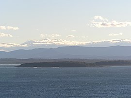
The Moruya River is an open and trained mature wave dominated barrier estuary or tidal river is located in the South Coast region of New South Wales, Australia. In its upper freshwater reaches, the river is known as the Deua River.

<span class="mw-page-title-main">Ninety Mile Beach, Victoria</span>

The Ninety Mile Beach is a sandy stretch of beach on the south-eastern coastline of the East Gippsland region of Victoria in Australia. The beach faces Bass Strait and backs the Gippsland Lakes. The beach is just over 151 kilometres (94 mi) in length, running north-eastward from a spit near Port Albert to the man-made channel at Lakes Entrance.

<span class="mw-page-title-main">Mogo, New South Wales</span> Town in New South Wales, Australia

Mogo is a small heritage town in the South Coast region of the state of New South Wales, Australia. Mogo is administered by the Eurobodalla Shire council. The town is located on the Princes Highway, south of Batemans Bay and north of Moruya. At the 2016 census, Mogo had a population of 322.

<span class="mw-page-title-main">Lennox Head, New South Wales</span> Town in New South Wales, Australia

Lennox Head is a seaside village in the Northern Rivers region of New South Wales, Australia, situated on the stretch of coast between Byron Bay and Ballina in Ballina Shire local government area. It had a population of 7,741 in the 2016 Australian census.

<span class="mw-page-title-main">Rosedale, New South Wales</span> Town in New South Wales, Australia

Rosedale is a beachside settlement in New South Wales, Australia. It is on the south coast, about 18 kilometres by road south of Batemans Bay. The area is administered by the Eurobodalla Shire. At the 2016 census, Rosedale had a population of 221.

<span class="mw-page-title-main">Fingal Head, New South Wales</span> Town in New South Wales, Australia

Fingal Head is a village on the Tasman Sea coast in the far northeast of New South Wales, Australia, about 5 km south of the New South Wales and Queensland border. The village is often just called Fingal. The headland and the small off-shore Island were first sighted by James Cook about 17:00 on 16 May 1770. At the time of the 2021 census, Fingal Head had a population of 592 people.

<span class="mw-page-title-main">Broulee Island Nature Reserve</span> Protected area in New South Wales, Australia

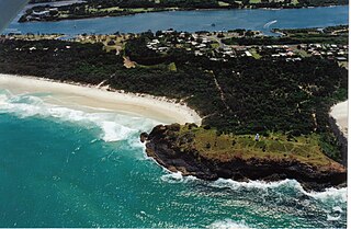
The Broulee Island Nature Reserve is a protected nature reserve located on the south coast of New South Wales, Australia. The 43 ha reserve was created in 1972 and is managed by the NSW National Parks & Wildlife Service. The reserve is situated 23 kilometres (14 mi) south of Batemans Bay and is adjacent to the village of Broulee. In the twenties of the last century, there was a small port here from which a large amount of shellgrit was taken to Sydney, where they were made of lime and used in construction.

<span class="mw-page-title-main">Araluen, New South Wales</span> Town in New South Wales, Australia

Araluen is a small town near Braidwood in the Southern Tablelands of New South Wales, Australia, in Queanbeyan-Palerang Regional Council. It lies in the valley of Araluen Creek, that joins the Deua River at roughly the midpoint in its course. At the 2021 census, Araluen had a population of 209 people.

<span class="mw-page-title-main">Deua River</span> River in New South Wales, Australia

The Deua River, being the main perennial river of the Moruya River catchment, is located in the South Coast region of New South Wales, Australia.

<span class="mw-page-title-main">Scotts Head, New South Wales</span> Suburb of Nambucca Valley Council, New South Wales, Australia

Scotts Head is a coastal village of the Nambucca Valley local government area in the Mid North Coast region of New South Wales, Australia. Located on the coast of the Pacific Ocean, approximately 10 kilometres (6 mi) from the Pacific Highway and 480 kilometres (300 mi) from Sydney, it stretches southwards from just south of the mouth of the Nambucca River to the town of Scotts Head in the south.

<span class="mw-page-title-main">Majors Creek, New South Wales</span> Town in New South Wales, Australia

Majors Creek is a small village in the Southern Tablelands region of New South Wales, Australia. The nearest major town is Braidwood, 16 km (9.9 mi) to the north. At the 2021 census, the population of Majors Creek was 290. A former gold mining town, the settlement is today associated with the operational Dargues Reef gold mine. The name, Majors Creek is also applied to the surrounding area, for postal and statistical purposes.

Cotton Tree is a coastal neighbourhood within the suburb of Maroochydore in the Sunshine Coast Region, Queensland, Australia.

<span class="mw-page-title-main">Tomakin, New South Wales</span> City in New South Wales, Australia

Tomakin is a small seaside village on the south coast of New South Wales between the major towns of Batemans Bay and Moruya. At the 2016 census, the town had a population of 1,001. It is most closely flanked by the other small villages of Guerilla Bay and Mossy Point.

The Walbunja, also spelt Walbanga and Walbunga, are an Aboriginal Australian people of New South Wales, part of the Yuin nation.

<span class="mw-page-title-main">Merricumbene</span> Town in New South Wales, Australia

Merricumbene is a locality in the Eurobodalla Shire, New South Wales, Australia. It is located about 43 km south of Braidwood and 40 km northwest of Moruya in the valley of the Deua River. At the 2016 census, it had a population of 19.

<span class="mw-page-title-main">James Larmer</span>

James Larmer was a government surveyor in the colony of New South Wales. Between 1830 and 1859, he surveyed land, roads and settlements in New South Wales. He was an Assistant Surveyor to the Surveyor-General, Sir Thomas Mitchell, from 1835 to 1855. In 1835, he was second in command of Mitchell's second expedition. He is also noteworthy for his recording of Aboriginal words from various parts of New South Wales.

Captain William Oldrey (1787—1851) was an officer in the Royal Navy and later a colonial settler of New South Wales, Australia. He is particularly associated with the early days of Broulee, on the South Coast of New South Wales.

<span class="mw-page-title-main">John Hawdon (colonial settler)</span> Australian colonial settler (1801–1881)

John Hawdon (1801—1881) was an English-born colonial settler of New South Wales. He is associated with the area around Moruya, particularly Kiora and Tuross Head, on the South Coast of New South Wales, Australia, although he was also a pioneering landholder of other areas of the colony.

References

  1. Australian Bureau of Statistics (28 June 2022). "Broulee (suburb and locality)". Australian Census 2021 QuickStats. Retrieved 28 June 2022.  OOjs UI icon edit-ltr-progressive.svg
  2. "Broulee". Geographical Names Register (GNR) of NSW. Geographical Names Board of New South Wales . Retrieved 31 January 2018. OOjs UI icon edit-ltr-progressive.svg
  3. "Broulee". OpenStreetMap. Retrieved 31 January 2018.
  4. Australian Bureau of Statistics (27 June 2017). "Broulee (state suburb)". 2016 Census QuickStats. Retrieved 8 July 2017. OOjs UI icon edit-ltr-progressive.svg
  5. "Map, Broulee; James Larmer; c.1839; 009/072a on eHive". eHive. Retrieved 14 July 2020.
  6. totalecoadventures (6 September 2010). "Chased by a friendly whale -- a stand up paddle (SUP) experience on the NSW south coast, Australia" . Retrieved 17 September 2016 via YouTube.[ dead YouTube link ]
  7. auntybikkie (26 August 2010). "Whales at Moruya River II". Archived from the original on 21 December 2021. Retrieved 17 September 2016 via YouTube.
  8. bengello (28 August 2010). "Moruya". Archived from the original on 21 December 2021. Retrieved 17 September 2016 via YouTube.
  9. "The Bower - Summer break on the South Coast". Archived from the original on 29 June 2016. Retrieved 17 September 2016.
  10. "Moruya Hospital - CaravanCampingOz.com BLOG : CaravanCampingOz.com BLOG". Archived from the original on 4 August 2013. Retrieved 9 May 2014.