Batemans Bay is a town on the South Coast region of the state of New South Wales, Australia. Batemans Bay is administered by the Eurobodalla Shire council and the NSW Aboriginal Land Council. The town is situated on land traditionally occupied by the Walbunja people from the Yuin nation, on the shores of an estuary formed where the Clyde River meets the southern Pacific Ocean.

Palm Beach is a suburb in the Northern Beaches region of Sydney, in the state of New South Wales, Australia. Palm Beach is located 41 kilometres (25 mi) north of the Sydney central business district, in the local government area of Northern Beaches Council. Palm Beach sits on a peninsula at the end of Barrenjoey Road, between Pittwater and Broken Bay. The population of Palm Beach was 1,593 as at the 2016 census.

Ballina is a town in the Northern Rivers region of New South Wales, Australia, and the seat of the Ballina Shire local government area. Ballina's urban population at June 2018 was 26,381. The town lies on the Richmond River and serves as a gateway to Byron Bay.

Torquay is a seaside resort in Victoria, Australia, which faces Bass Strait, 21 km south of Geelong and is the gateway to the Great Ocean Road. It is bordered on the west by Spring Creek and its coastal features include Point Danger and Zeally Bay. At the 2016 census, Torquay had a population of 13,258.

Eurobodalla Shire is a local government area located in the South Coast region of New South Wales, Australia. The Shire is located in a largely mountainous coastal region and situated adjacent to the Tasman Sea, the Princes Highway and the Kings Highway.

Cronulla is a suburb of Sydney, in the state of New South Wales, Australia. Boasting numerous surf beaches and swimming spots, the suburb attracts both tourists and Greater Sydney residents. Cronulla is located 26 kilometres south of the Sydney central business district, in the local government area of the Sutherland Shire.

Coogee is a beachside suburb of local government area City of Randwick 8 kilometres south-east of the Sydney central business district, in the state of New South Wales, Australia. It is typically associated as being part of the Eastern Suburbs region.
Sawtell is a suburb of the City of Coffs Harbour in northern New South Wales, Australia. It borders Toormina to the West.

Inverloch is a seaside town located in Victoria, Australia. It is located 143 kilometres (89 mi) south east of Melbourne via the South Gippsland Highway on the Bass Highway in the Bass Coast Shire of Gippsland, Victoria, Australia. Known originally for the calm waters of Anderson Inlet, it is now also known for the discovery of Australia's first dinosaur bone.

Negril is a small but widely dispersed beach resort town located across parts of two Jamaican parishes, Westmoreland and Hanover.
Stockton is a suburb of Newcastle, New South Wales, Australia, located 600 m (0.4 mi) from Newcastle's central business district. It is the only residential suburb of the City of Newcastle that lies north of the Hunter River.
The Gove Peninsula is at the northeastern corner of Arnhem Land in the Northern Territory of Australia. The peninsula became strategically important during World War II when a Royal Australian Air Force base was constructed at what is now Gove Airport. The peninsula was involved in a famous court case known as the Gove land rights case, when local Yolngu people tried to claim native title over their traditional lands in 1971, after the Australian Government had granted a mineral lease to a bauxite mining company without consulting the local peoples. Today the land is owned by the Yolngu people.
Mollymook is located on the South Coast of New South Wales, Australia approximately three hours' drive south of Sydney within the City of Shoalhaven local government area. At the 2016 census, Mollymook had a population of 1,083 while the adjacent locality of Mollymook Beach was home to a further 2,447 people. Geographically, Mollymook is considered part of the Milton-Ulladulla district, a coastal corridor of urban development stretching from Burrill Lake, south of Ulladulla to Mollymook's northern neighbour, Narrawallee and the historic town of Milton a few kilometres inland.

Clovelly is a small beach-side suburb in Sydney's eastern suburbs, in the state of New South Wales, Australia. Clovelly is located 8 kilometres south-east of the Sydney central business district, in the local government area of the City of Randwick, within the Federal Division of Wentworth.

Broulee is a town on the south coast of New South Wales between Batemans Bay and Moruya. At the 2016 census, the town had a population of 1,717. Just off the beach is Broulee Island, currently joined to the mainland, but in past years the connecting spit has been covered by water, at times a very deep navigable channel with a strong current.

Rosedale is a beachside settlement in New South Wales, Australia. It is on the south coast, about 18 kilometres by road south of Batemans Bay. The area is administered by the Eurobodalla Shire. At the 2016 census, Rosedale had a population of 221.

Merimbula is a town on the Merimbula Lake, located on the Far South Coast or Sapphire Coast of New South Wales, Australia. At the 2016 census, the population was 3,544.
Rossnowlagh is a seaside village in the south of County Donegal, Ireland. It is about 8 kilometres (5 mi) north of Ballyshannon and 16 km (10 mi) southwest of Donegal Town. The area's 3 km (2 mi) long beach, or 2 km (1.2 mi) if measuring from the cliffs to Carrickfad, is frequented by walkers, surfers, windsurfers, kite-surfers and swimmers.

Gracetown is a small town in Western Australia. It is located 269 kilometres (167 mi) south of the Perth central business district, and 21.5 kilometres (13.4 mi) north-west of the township of Margaret River in the Augusta-Margaret River Shire Council area on the coast at Cowaramup Bay.
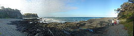
Surf Beach is a suburb of Batemans Bay in Eurobodalla Shire, New South Wales, Australia. It lies on the Tasman Sea coast, about 10 km southeast of Batemans Bay and 285 km south of Sydney. At the 2016 census, it had a population of 1,874.