Ben Boyd National Park is a national park in New South Wales, Australia, 578 km (359 mi) south of Sydney.

Glen Innes is a parish and town on the Northern Tablelands, in the New England region of New South Wales, Australia. It is the centre of the Glen Innes Severn Shire Council. The town is located at the intersection of the New England Highway and the Gwydir Highway. At the 2016 census, Glen Innes had a population of 6,155.

Glenelg is a beach-side suburb of the South Australian capital of Adelaide. Located on the shore of Holdfast Bay in Gulf St Vincent, it has become a tourist destination due to its beach and many attractions, home to several hotels and dozens of restaurants.
Eden is a coastal town in the South Coast region of New South Wales, Australia. The town is 478 kilometres (297 mi) south of the state capital Sydney and is the most southerly town in New South Wales, located between Nullica Bay to the south and Calle Calle Bay, the northern reach of Twofold Bay, and built on undulating land adjacent to the third-deepest natural harbour in the southern hemisphere, and Snug Cove on its western boundary. At the 2016 census, Eden had a population of 3,151.

Ermington(formerly "Field of Mars") is a suburb of Sydney, New South Wales, Australia. Ermington is located 19 kilometres north-west of the Sydney central business district, in the local government area of the City of Parramatta. Ermington lies on the northern bank of the Parramatta River.

Benjamin Boyd was a Scottish entrepreneur who became a major shipowner, banker, grazier, politician and slaver, exploiting South Sea Islander labour in the colony of New South Wales.

Twofold Bay is an open oceanic embayment that is located in the South Coast region of New South Wales, Australia.
Coffin Bay, originally Coffin's Bay, is a town at the southern extremity of the Eyre Peninsula, a wheat growing area of South Australia. At the 2016 census, Coffin Bay had a population of 611.

The South Coast refers to the narrow coastal belt from Shoalhaven district in the north to the border with Victoria in the south in the south-eastern part of the State of New South Wales, Australia. It is bordered to the west by the coastal escarpment of the Southern Tablelands, and is largely covered by a series of national parks, namely Jervis Bay National Park, Eurobodalla National Park, and Ben Boyd National Park. To the east is the coastline of the Pacific Ocean, which is characterised by rolling farmlands, small towns and villages along a rocky coastline, interspersed by numerous beaches and lakes.
Whaling in Australian waters began in 1791 when five of the 11 ships in the Third Fleet after landing their passengers and freight at Sydney Cove then left Port Jackson to engage in whaling and seal hunting off the coast of Australia and New Zealand. The two main species hunted by such vessels in the early years were right and sperm whales. Later, humpback, bowhead and other whale species would be taken.
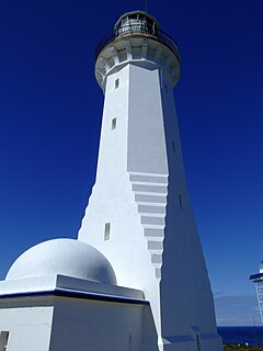
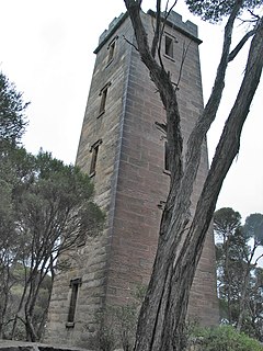
The Green Cape Lighthouse is a heritage-listed lighthouse located at the tip of Green Cape, a headland forming the northern boundary of Disaster Bay, in southern New South Wales, Australia. It is the southernmost lighthouse in New South Wales and Australia's first lighthouse built in concrete. At 29 metres (95 ft) it is also the second tallest lighthouse in New South Wales. It marks Green Cape on the northerly shore-hugging sailing course.
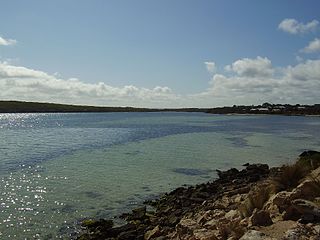
Bittangabee Bay is a tiny, picturesque bay on the rugged and remote stretch of coastline south of Eden in New South Wales, Australia. The bay is located in Ben Boyd National Park, and there is a campground nearby. The facilities are maintained by National Parks and Wildlife Service (NPWS), Merimbula office. It can be reached by an unsealed road from the Princes Highway. The bay is the only haven between Twofold Bay and Mallacoota Inlet, and passing yachts are seen anchored for the night there most evenings. It is fed by Bittangabee Creek.
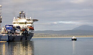
The Port of Eden is a small seaport situated in Twofold Bay, adjacent to the town of Eden, located in the South Coast region of New South Wales, Australia.

The Low Rocky Point is a location on the south west coast of Tasmania, Australia, that is used as a location for weather forecasting. It is almost due west of Hobart, it is south of Point Hibbs and north of South West Cape.
Boyd River, a perennial stream that is part of the Clarence River catchment, is located in the Northern Tablelands district of New South Wales, Australia.
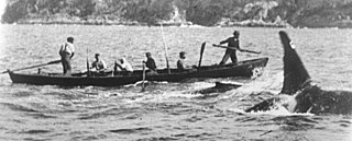
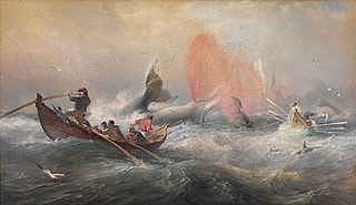
The killers of Eden or Twofold Bay killers were a group of killer whales known for their co-operation with human hunters of cetacean species. They were seen near the port of Eden in southeastern Australia between 1840 and 1930. A pod of killer whales, which included amongst its members a distinctive male called Old Tom, would assist whalers in hunting baleen whales. The killer whales would find target whales, shepherd them into Twofold Bay or neighbouring regions of coast, and then often swim many kilometres away from the location of the hunt to alert the whalers at their cottage to their presence and often help to kill the whales.

Bibbenluke is a village in the Snowy Monaro Regional Council in southern New South Wales, Australia. The village is located at a crossing point of the Monaro Highway and Bombala River. The name is derived from a local Aboriginal word either meaning "Big Lookout" or "Place of Birds".
Rivoli Bay, is a bay located on the south-east coast of the Australian state of South Australia about 311 kilometres south-southeast of the state capital of Adelaide and about 65 kilometres northwest by west of the regional centre of Mount Gambier. It was named in 1802 by the Baudin expedition of 1800-03 after André Masséna, the Duke of Rivoli and Marshal of France. It is one of four 'historic bays' located on the South Australian coast.

Davidson Whaling Station is a heritage-listed former whaling station at Edrom, Bega Valley Shire, New South Wales, Australia. It was built in 1896. The property is owned by the New South Wales Office of Environment and Heritage. It was added to the New South Wales State Heritage Register on 2 April 1999.

The Bundian Way is a heritage-listed former 265-kilometre (165 mi) Aboriginal travelling route for cultural use, maritime trade, education, and exploration. The route now forms part of the Kosciuszko National Park, state forest, and local roads from Mount Kosciuszko through Snowy Monaro Regional Council to Eden in New South Wales, Australia. It is also known as Aboriginal track path. It was added to the New South Wales State Heritage Register on 18 January 2013.


