History
On 23 April 1770, James Cook in HMS Endeavour made his first recorded direct observation of indigenous Australians at Brush Island near Bawley Point, noting in his journal: "...and were so near the Shore as to distinguish several people upon the Sea beach they appear'd to be of a very dark or black Colour but whether this was the real colour of their skins or the Clothes they might have on I know not." [5]
On 18 December 1832 Joseph Berryman, overseer at Sydney Stephen's Murramarang land acquisition near Bawley Point, shot dead four Aboriginal Australians in retaliation for the spearing of some cattle. Of those shot, two were an elderly couple and another was a pregnant woman. [6]
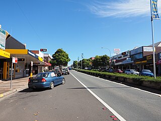
Bawley Point had a public school from 1894 to 1909 and 1912 to 1922, classified variously as a "public", "half-time" or "provisional" school. [7]
Bawley Point was threatened during the 2019-20 Bushfire Season, with local fire Chief Charlie Magnuson calling it "the luckiest village on the South Coast". [8]
Tourism
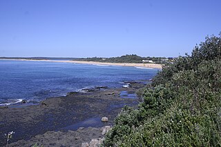
Bawley Point and the adjacent areas have dozens of accommodation options for tourists, from bush cottages, to home stays and caravan parks. The tourism industry is one of the primary sources of incomes for many in the region. Whilst the majority of visitors come from the nearby capital cities of Canberra and Sydney, Bawley Point hosts many international visitors.
Even in the busier periods of the summer holidays, the area is fortunate to have many beaches which provides the favourite attraction of the area. Surrounded by national parks, the area has bush walking trails, mountain biking and campgrounds.
There are two wineries in the area popular tourist attractions which also bring visitors to the area during the Shoalhaven Winter Wine Festival. Visitors can also enjoy fruit picking at two of the local farms.
In addition to the beaches, the area has a couple lakes and lagoons surrounded by National Parks, these bring tourists to the area for photography, painting and bird watching. [9]

The Morton National Park is a 199,745-hectare (493,580-acre) national park located in the Southern Highlands, South Coast and Illawarra regions of New South Wales, Australia, situated approximately 170 kilometres (110 mi) south southwest of Sydney.

Murramarang is a national park in New South Wales, Australia, 206 km (128 mi) southwest of Sydney. It follows the coastline from Long Beach north to Merry Beach near Ulladulla. It is surrounded by three state forests, Kioloa, South Brooman, and Benandarrah. The park forms part of the Ulladulla to Merimbula Important Bird Area, identified as such by BirdLife International because of its importance for swift parrots.

The City of Shoalhaven is a local government area in the south-eastern coastal region of New South Wales, Australia. The area is about 200 kilometres (120 mi) south of Sydney. The Princes Highway passes through the area, and the South Coast railway line traverses the northern section, terminating at Bomaderry. At the 2016 census, the population was 99,650.

Milton is a village in the South Coast region of New South Wales, Australia, within the City of Shoalhaven. It was founded in 1860, named after the property of post master George Knight and became an important regional centre during the 19th Century. Today, Milton remains one of the two main commercial centres of the Milton-Ulladulla district, with a population at the 2016 census of 1,663. It is a popular stopping place for travellers on the Princes Highway which runs through the centre of town. In recent years, Milton has undergone a resurgence largely influenced by the local tourism industry and an influx of residents to the district seeking a seachange. Several new housing estates are being developed on the fringes of the village and new boutique stores, cafes and bed and breakfast type businesses have located in the town.
Ulladulla is a coastal town in New South Wales, Australia in the City of Shoalhaven local government area. It is on the Princes Highway about 230 kilometres (140 mi) south of Sydney, halfway between Batemans Bay to the south and Nowra to the north. Ulladulla has close links with the nearby historic settlement of Milton and many services are shared between these towns.

Jervis Bay is a 102-square-kilometre (39 sq mi) oceanic bay and village on the south coast of New South Wales, Australia, said to possess the whitest sand in the world.

Nowra is a city in the South Coast region of New South Wales, Australia. It is located 160 kilometres (99 mi) south-southwest of the state capital of Sydney. As of the 2016 census, Nowra has an estimated population of 20,039. Situated in the southern reaches of the Sydney basin, Nowra is the seat and commercial centre of the City of Shoalhaven.

Gerringong is a town located about ten minutes drive south of Kiama in the Illawarra region of New South Wales, Australia in the Municipality of Kiama. At the 2016 census, Gerringong had a population of 3,966. One theory says that the name derives from an Aboriginal word meaning "fearful place".

Mittagong is a town located in the Southern Highlands of New South Wales, Australia, in Wingecarribee Shire. The town acts as the gateway to the Southern Highlands when coming from Sydney. Mittagong is situated at an elevation of 635 metres (2,083 ft). The town is close to Bowral, Berrima, Moss Vale and the Northern Villages such as Yerrinbool and Colo Vale. Moreover, Mittagong is home to many wineries of the Southern Highlands which has been a recent growing wine and cellar door region.

Vincentia is a town in New South Wales, Australia in the City of Shoalhaven, on the shores of Jervis Bay. It is roughly 25 kilometres (16 mi) southeast of Nowra, and approximately 200 kilometres (120 mi) south of Sydney. At the 2016 census, the population of Vincentia was 3,290. It is also a tourist spot with a beach area featuring white sand and a number of motels.
Culburra Beach, commonly referred to as Culburra, is a town located in the South Coast region of New South Wales, Australia. Located within the Shoalhaven local government area, the town is 18 kilometres (11 mi) east-southeast of Nowra on Jerrinja Wandi Wandian Aboriginal Country. At the 2016 census, the town had a population of 2,874 and is the regional centre for the coastal villages of Currarong, Callala Beach, Callala Bay and Orient Point.
Hyams Beach is a seaside village in the City of Shoalhaven, New South Wales, Australia, on the shores of Jervis Bay. At the 2016 census, it had a population of 112. The village, 180 km south of Sydney, is bordered by two beaches, Chinaman's Beach to the north and Seaman's Beach to the south, with Hyams Beach being in the centre. A seaside resort, its beach is known for having turquoise/aqua-coloured waters and fine, squeaky, brilliantly white sand that's composed of pure quartz.

Lake Conjola is a small town situated on the South Coast of New South Wales, Australia. It is located in the region of Ulladulla, in the City of Shoalhaven. At the 2016 census, Lake Conjola had a population of 437. Lake Conjola is a popular tourist destination for boaters and fisherman. Fish in the lake include bream, whiting, tailor, flathead, black fish, and jewfish. Lake Conjola is located on the southern side of Green Island, a renowned surf break. There are 4 caravan parks with cabins, caravan areas, tent areas, and waterfronts.

The South Coast refers to the narrow coastal belt from Shoalhaven district in the north to the border with Victoria in the south in the south-eastern part of the State of New South Wales, Australia. It is bordered to the west by the coastal escarpment of the Southern Tablelands, and is largely covered by a series of national parks, namely Jervis Bay National Park, Eurobodalla National Park, and Ben Boyd National Park. To the east is the coastline of the Pacific Ocean, which is characterised by rolling farmlands, small towns and villages along a rocky coastline, interspersed by numerous beaches and lakes.

Kioloa is a small hamlet located on the South Coast of New South Wales, Australia and is within the City of Shoalhaven local government area. It is pronounced by locals as 'Ky-ola'. At the 2016 census, Kioloa had a population of 257.

Tabourie Lake, formerly Toubouree Lake is a small village in the suburb of Lake Tabourie, in the South Coast region of New South Wales, Australia and is within the City of Shoalhaven local government area. The village takes its name from the lagoon formed at the entry of Tabourie Creek into the ocean. Crampton Island lies immediately off shore with access available by foot at low tide. A caravan and camping park is located between the beach and lake. The village boasts a small museum, opened in 1965 with a collection of local historical exhibits, including fauna, Aboriginal artifacts, and historical furnishings and machinery. The museum and collection was given to the Shoalhaven City Council by its founder Jack Nicholson in 1983.

Burrill Lake is a small village on the Princes Highway in the South Coast region of New South Wales, Australia. It is a seaside suburb of the Milton-Ulladulla district, a part of the City of Shoalhaven local government area and surrounds the lake of the same name. In 2016, the population Burrill Lake has a population of 1,465. The name of the town is derived from an Aboriginal word meaning 'wallaby'.

Termeil is a small village in the Shoalhaven area of New South Wales, Australia. Termeil is a predominantly rural hamlet at the junction of Bawley Point Road, providing access to the beachside communities of Bawley Point and Kioloa and the Princes Highway. At the 2011 census the population was 252. Ulladulla Bus Lines route 741 serves Termeil twice per day on weekdays.

Narrawallee is a coastal village in the South Coast region of New South Wales, Australia. At the 2016 census, it had a population of 1,241. The village, along with its southern neighbours Mollymook and Mollymook Beach are generally considered part of the Milton-Ulladulla district within the City of Shoalhaven local government area. Narrawallee is predominantly a residential suburb, bordered by a tidal inlet to the north and Matron Porter Drive. The name "Narrawallee" is taken from the creek which flows eastwards from Milton and its estuary on the Tasman Sea and is itself a corruption of the Aboriginal words Nurrawerree or Narra Warra.

Kings Point is a village in the South Coast region of New South Wales, Australia. The village forms part of the Milton Ulladulla urban area in the southern Shoalhaven. Kings Point is predominantly a residential suburb on the shores of Burrill Lake. A small light industrial area to the east separates the village from Ulladulla. At the 2016 census, Kings Point had a population of 553. The lakeside location makes Kings Point popular for fishing and water sports - the Ulladulla Water Ski Club and public boat ramp facilities allow locals and visitors to take full advantage.


